19:
95:
361:. According to Beveridge, the events within this version of the tradition were said to have taken place at the precise date of 1384. However, he conceded that this date was calculated by the fact that when the Macleans of Coll sold their estate on the island in 1854, it was believed that they had owned their lands there for exactly 472 years. Beveridge also noted that the first historical connection between any Maclean and the island of Coll appears in a charter of confirmation, dated 1495, which states the Macleans were granted a charter to the island in 1409. Beveridge's version of the tradition runs as follows:
204:
is about 1.2 metres (3 ft 11 in) above the level plane of the island, and is heavily overgrown with vegetation. The summit is also the site of the remains of three round-angled conjoined buildings that are rectangular in shape. All three buildings are aligned north–south, with their long axis parallel to the shore closest. The two main buildings are situated in a linear plan, aligned north–south. The walls of both structures are of dry-stone construction and are on average about 1.3 metres (4 ft 3 in) thick; standing to a maximum height of 1.5 metres (4 ft 11 in).
233:
422:
183:. Holley noted that the causeway had two defensive features. One was a 25 degree bend at the middle of the causeway; and the other was a rocking stone which tilts when under pressure. Holley recorded the depth of the loch around the island at 1 metre (3 ft 3 in) to 1.5 metres (4 ft 11 in) deep, with the deeper water on the western side. He noted that the surrounding water-bed was heavily silted, concealing the bottom; at least 2 metres (6 ft 7 in) deep.
379:... according to Coll tradition, Maclean of Duart, on his way to Tiree calling at Coll for provisions, was told by a woman that he was unworthy of them so long as he allowed Lochluinnich or Norsemen to possess Coll. He thereupon attacked the three brothers from Lochlinn who held Coll then, viz., Amlamh Mór on the island fort Dun Anlaimh in Loch nan Cinneachan, another in Dun Bithig in Totronald, and another at Dun Dubh in Grisbol hill. The fight took place at Grimsary.
348:
299:, and the third in Grisipol hill. She had thirty men herself fit to bear arms. Dowart went to Loch Annla fort late in the evening alone, and was hospitably received. Annla's arrows were near the fire, and Dowart gradually edged near them till he managed to make off with them. This led to a fight at Grimsari and is perhaps the reason why Dowart encouraged
223:
Like several other crannogs on Coll—such as those of Loch
Anlaimh, Loch an Duin, and Loch Cliad—Dùn Anlaimh appears to have defensive features, in form of a bending causeway, incorporated within it. If the curving causeways of these crannogs were meant to lie under several feet of shallow
203:
enclosure are sometimes visible on the stony part of the island. The north part of the outer face of these remains stand at a maximum of about 0.8 metres (2 ft 7 in). A small inlet, located in the south-west corner of the island, may indicate the site of a boat landing. The island's summit
191:
According to the RCAHMS, it is difficult to estimate the age of the remains of Dùn
Anlaimh. The ruins seem to resemble later fortified islands found in the Outer Hebrides, and it is likely that those of Dùn Anlaimh date to the mediaeval period. Although the site has no recorded history, the local
365:
Concerning the first of these two island-forts,—Dun
Anlaimh, in the Upper Mill Loc,—there runs a somewhat detailed tradition to the effect that in it lived the Norse chief who held Coll long after the neighbouring islands had been abandoned by his comrades. It is said that MacLean of
178:
in 1975. The RCAHMS recorded the dimensions of the island at about 28 metres (91 ft 10 in) on the north–south axis and about 23 metres (75 ft 6 in) on the east–west axis. In 1995, Mark W. Holley surveyed the site and measured it 28 by 35 metres (91 ft 10 in by
179:
114 ft 10 in) at the base of the island. The island is composed of about 80% medium-sized boulders and 20% large boulders. The island is situated on the north end of Loch nan
Cinneachan and is connected to the east shore by a 29 metres (95 ft 2 in) partly submerged
220:. It is 3.2 metres (10 ft 6 in) long from the north-east to south-west corner, and 2.1 metres (6 ft 11 in) transversely. The walls are on average 0.8 metres (2 ft 7 in) thick. The entrance to the building is located on south-west end wall.
344:. Beveridge reasoned that this particular battle against the MacNeils probably took place around 1470–1480; and wondered if there could be some sort of confusion between this conflict with the MacNeils and that of the Norsemen.
132:, the two lochs probably were joined at one time, and that this would explain why Dùn Anlaimh is not located within Loch Anlaimh. Beveridge also thought the names of the lochs were suggestive. According to him, the Gaelic
374:
A version very similar to
Beveridge's appears in the 1906 monograph written by Rev. Dugald MacEchern which was published in 1922. MacEchern acknowledges the work of Beveridge and his version runs as follows:
331:
1450) is claimed to be the ancestor of the
Macleans of Coll. Beveridge also made note of traditions of another battle fought near Grishipol, in which Iain Garbh and his followers defeated a force led by his
448:
as: "An island, partly or wholly artificial, often formed by dumping timber, earth and stones and revetted with timber piles or a palisade. Built in a loch, wetland or estuary and dating from prehistory to
287:). The woman of the house told MacLean was not worth sending meat to, and Dowart kindly came ashore to see why she said so. She said it because he was not taking Coll for himself. Three brothers from
1182:
208:
is 7.1 metres (23 ft 4 in) long and 4.1 metres (13 ft 5 in) wide, with a doorway about 1 metre (3 ft 3 in) wide located on the north end of the west side wall.
121:). The loch lies directly north of Loch Anlaimh which also has an artificial island within it. Confusingly, Dùn Anlaimh sometimes appears as "Eilean nan Cinneachan" on maps (see
927:
531:
444:
as: "A small, sometimes partly artificial, island with evidence of buildings and other structures related to domestic occupation, generally of medieval date"; and a
355:
In 1903, without prior knowledge to
Campbell's tradition, Beveridge published another version of the 'Norsemen tradition' quoted above; one in which he had obtained
796:
The Gaelic
Otherworld: John Gregorson Campbell's superstitions of the Highlands and Islands of Scotland and witchcraft and second sight in the Highlands and Islands
1197:
57:. According to local tradition on Coll, the fort was once the home of a Norse chieftain who was defeated in battle somewhere nearby. The early 20th century
49:. Upon the crannog there are the remains of walls and several buildings. These remains are not unlike those of other fortified islands found throughout the
370:) in this islet stronghold. The Norweigens, finding themselves overcome, threw their weapons into the loch, to put these beyond the reach of their victors.
920:
117:
78:
876:
811:
300:
1202:
913:
383:
The tradition of Dùn
Anlaimh has led some modern historians and scholars to regard the defeated Anlaimh as a possible progenitor of the
18:
858:
174:
The island upon which Dùn
Anlaimh occupies is roughly oval, almost circular in plan, and was about water level when visited by the
410:
54:
94:
482:
1192:
256:
In the late 19th and early 20th centuries, several Coll traditions were published which concerned several fortifications (
74:
320:
232:
216:
is a smaller building which abuts the west wall of the main range. It lies adjacent to the entrance doorway of
638:
125:
map pictured left) and the island in Loch Anlaimh is known as "Eilean Anlaimh". According to the 20th century
264:
260:, duns, and crannogs) on the island—one of which was Dùn Anlaimh. One such tradition was collected by
691:
617:
366:
Duart already possessed Tiree, and that one of his sons determined to attack the Norseman (presumably an
487:
224:
water, these bends would have served to impede the advancement of enemies unaware of the correct route.
61:
Erskine Beveridge considered it as one of the four most interesting fortifications, on Coll (along with
563:
799:
421:
237:
347:
1015:
1010:
212:
is 5.6 metres (18 ft 4 in) long and 3.4 metres (11 ft 2 in) wide internally.
991:
115:
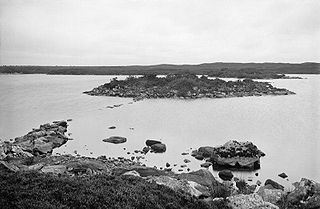
Dùn Anlaimh is a small artificial island located in Loch Nan Cinneachan on Coll (grid reference
1122:
1117:
1075:
1020:
854:
807:
737:
709:
591:
536:
509:
404:
384:
129:
62:
1040:
193:
70:
307:
According to Beveridge in 1903, the forts mentioned within this tradition are Dùn Anlaimh,
1151:
1088:
122:
99:
1127:
685:
611:
192:
tradition concerning Dùn Anlaimh appears to support the view that it was occupied in the
1161:
1132:
1112:
1083:
986:
961:
392:
164:
50:
42:
1187:
1176:
1107:
971:
777:
760:
357:
157:
1156:
1064:
1045:
951:
943:
865:
837:
337:
324:
261:
153:
1035:
1030:
981:
333:
312:
308:
66:
976:
966:
905:
891:
878:
745:
517:
296:
279:
of Dowart was on his way to gather rent in Tiree, and sent ashore to Kelis (
200:
126:
58:
684:
Campbell, John Gregorson (1895), MacIsaac, Duncan; Wallace, Jessie (eds.),
141:
1099:
956:
288:
257:
241:
180:
145:
245:
149:
38:
851:
Warriors and priests: the history of the Clan Maclean, 1300–1570
687:
Clan Traditions and Popular Tales of the Western Highlands and Islands
437:
175:
163:
can also be linked with the Norsemen as it is a Gaelicisation of the
83:
646:
1143:
1056:
782:, vol. 29, The Gaelic Society of Inverness, 1922, p. 316
765:, vol. 29, The Gaelic Society of Inverness, 1922, p. 314
346:
341:
276:
268:
231:
93:
41:(an artificial island), located within Loch nan Cinneachan on the
1002:
407:, another dun on Coll traditionally linked to an Amlamh, or Olaf
388:
249:
46:
909:
86:
classifies the site as a 'crannog' and an 'island dwelling'.
271:, and published in 1895 Campbell's version runs as follows:
827:
Matheson, William (1983), "Notes on North Uist Families",
387:, a family who are traditionally said to have settled on
558:
Holley, Mark W. (1995), "Crannog Survey (Coll parish)",
1183:
Archaeological sites in the Northern Inner Hebrides
1141:
1097:
1073:
1054:
1000:
941:
53:, and it is likely that Dùn Anlaimh dates from the
732:
730:
586:
584:
582:
580:
578:
576:
574:
98:Loch nan Cinneachan and Loch Anlaimh on an 1881
829:Transactions of the Gaelic Society of Inverness
779:Transactions of the Gaelic Society of Inverness
762:Transactions of the Gaelic Society of Inverness
377:
363:
273:
152:were sometimes styled as "Gentiles" within the
22:Dùn Anlaimh on Loch nan Cinneachan, about 1905
921:
8:
351:Dùn Anlaimh on Loch nan Cinneachan, in 2006.
668:Holley, Mark W. (1996), "Coll's Crannogs",
928:
914:
906:
704:
702:
295:) in Loch Annla, another in Dun bithig in
148:". During the early Middle Ages the pagan
102:map. On this map, Dùn Anlaimh appears as "
73:). The site of Dùn Anlaimh is located at
632:
630:
628:
483:"Coll, Dun Anlaimh, Loch Nan Cinneachan"
420:
17:
461:
429:
639:"Dun Anlaimh Crannog, Loch Cinneachan"
477:
475:
473:
471:
469:
467:
465:
748:: T. and A. Constable, pp. 55–60
598:, T. and A. Constable, pp. 25–29
7:
560:Discovery and Excavation in Scotland
1198:Former populated places in Scotland
228:Tradition of Anlaimh of Dùn Anlaimh
849:Maclean-Bristol, Nicholas (1995),
14:
532:"RCAHMS Thesaurus Browser Search"
520:: T. and A. Constable, p. 14
291:had Coll at the time, Big Annla (
411:Scotland in the Late Middle Ages
327:(d. after 1472). Iain Garbh (b.
643:Crannogs.com (www.crannogs.com)
303:to make himself master of Coll.
853:, Tuckwell Press, p. 34,
610:Gillies, Hugh Cameron (1906),
267:, a former parish minister of
1:
328:
140:mean loch and island of the "
1219:
1203:Fortifications in Scotland
936:Prehistoric Inner Hebrides
391:after emigrating from the
613:The Place Names of Argyll
336:Gilleonan, chief of the
385:MacAulays of North Uist
319:mentioned was a son of
265:John Gregorson Campbell
794:Black, Ronald (2005),
426:
381:
372:
352:
305:
253:
111:Analysis of the island
107:
23:
488:canmore.rcahms.gov.uk
424:
350:
235:
187:Analysis of the ruins
138:Eilean nan Cinneachan
104:Eilean nan Cinneachan
97:
35:Eilean nan Cinneachan
21:
1193:Crannogs in Scotland
564:Archaeology Scotland
425:Dùn Anlaimh in 1905.
199:The remains of on a
892:56.6189°N 6.58493°W
888: /
283:), Coll, for meat (
134:Loch nan Cinneachan
1016:Breachacha crannog
738:Beveridge, Erskine
592:Beveridge, Erskine
510:Beveridge, Erskine
427:
353:
311:at Totronald, and
254:
108:
24:
1170:
1169:
897:56.6189; -6.58493
813:978-1-84158-207-8
670:The Coll Magazine
649:on 19 August 2008
637:Holley, Mark W.,
537:www.rcahms.gov.uk
325:Macleans of Duart
321:Lachlann Bronnach
130:Erskine Beveridge
1210:
930:
923:
916:
907:
903:
902:
900:
899:
898:
893:
889:
886:
885:
884:
881:
868:
863:
846:
840:
835:
824:
818:
816:
791:
785:
783:
774:
768:
766:
757:
751:
749:
734:
725:
723:
722:
720:
706:
697:
695:
681:
675:
673:
672:, pp. 17–21
665:
659:
657:
656:
654:
645:, archived from
634:
623:
621:
607:
601:
599:
588:
569:
567:
555:
549:
547:
546:
544:
528:
522:
521:
506:
500:
498:
497:
495:
479:
450:
434:
330:
194:Late Middle Ages
120:
81:
55:late Middle Ages
29:, also known as
1218:
1217:
1213:
1212:
1211:
1209:
1208:
1207:
1173:
1172:
1171:
1166:
1152:Dun Bhruichlinn
1137:
1093:
1089:Tirefour Castle
1069:
1050:
996:
992:Rubha an Dùnain
937:
934:
896:
894:
890:
887:
882:
879:
877:
875:
874:
872:
871:
861:
848:
847:
843:
826:
825:
821:
814:
793:
792:
788:
776:
775:
771:
759:
758:
754:
736:
735:
728:
718:
716:
714:www.stirnet.com
708:
707:
700:
683:
682:
678:
667:
666:
662:
652:
650:
636:
635:
626:
609:
608:
604:
590:
589:
572:
557:
556:
552:
542:
540:
530:
529:
525:
508:
507:
503:
493:
491:
481:
480:
463:
458:
453:
442:island dwelling
435:
431:
419:
401:
323:, chief of the
230:
189:
116:
113:
100:Ordnance Survey
92:
77:
43:Inner Hebridean
12:
11:
5:
1216:
1214:
1206:
1205:
1200:
1195:
1190:
1185:
1175:
1174:
1168:
1167:
1165:
1164:
1162:Dun Nosebridge
1159:
1154:
1148:
1146:
1139:
1138:
1136:
1135:
1130:
1125:
1123:Dùn Meadhonach
1120:
1115:
1110:
1104:
1102:
1095:
1094:
1092:
1091:
1086:
1084:Eilean Musdile
1080:
1078:
1074:Sites on/near
1071:
1070:
1068:
1067:
1061:
1059:
1052:
1051:
1049:
1048:
1043:
1038:
1033:
1028:
1023:
1021:Dùn an Achaidh
1018:
1013:
1007:
1005:
998:
997:
995:
994:
989:
987:Dun Skudiburgh
984:
979:
974:
969:
964:
962:Dun Borrafiach
959:
954:
948:
946:
939:
938:
935:
933:
932:
925:
918:
910:
870:
869:
859:
841:
819:
812:
802:, p. 368
786:
769:
752:
742:Coll and Tiree
726:
698:
676:
660:
624:
602:
596:Coll and Tiree
570:
550:
523:
514:Coll and Tiree
501:
460:
459:
457:
454:
452:
451:
428:
418:
415:
414:
413:
408:
405:Dùn an Achaidh
400:
397:
393:Inner Hebrides
229:
226:
188:
185:
167:personal name
112:
109:
91:
88:
75:grid reference
63:Dùn an Achaidh
51:Outer Hebrides
13:
10:
9:
6:
4:
3:
2:
1215:
1204:
1201:
1199:
1196:
1194:
1191:
1189:
1186:
1184:
1181:
1180:
1178:
1163:
1160:
1158:
1155:
1153:
1150:
1149:
1147:
1145:
1140:
1134:
1131:
1129:
1126:
1124:
1121:
1119:
1116:
1114:
1111:
1109:
1106:
1105:
1103:
1101:
1096:
1090:
1087:
1085:
1082:
1081:
1079:
1077:
1072:
1066:
1063:
1062:
1060:
1058:
1053:
1047:
1044:
1042:
1041:Dùn Morbhaidh
1039:
1037:
1034:
1032:
1029:
1027:
1024:
1022:
1019:
1017:
1014:
1012:
1009:
1008:
1006:
1004:
999:
993:
990:
988:
985:
983:
980:
978:
975:
973:
972:Dun Fiadhairt
970:
968:
965:
963:
960:
958:
955:
953:
950:
949:
947:
945:
940:
931:
926:
924:
919:
917:
912:
911:
908:
904:
901:
867:
862:
860:9781898410621
856:
852:
845:
842:
839:
834:
830:
823:
820:
815:
809:
805:
801:
797:
790:
787:
781:
780:
773:
770:
764:
763:
756:
753:
747:
743:
739:
733:
731:
727:
715:
711:
705:
703:
699:
694:, p. 316
693:
689:
688:
680:
677:
671:
664:
661:
648:
644:
640:
633:
631:
629:
625:
620:, p. 123
619:
615:
614:
606:
603:
597:
593:
587:
585:
583:
581:
579:
577:
575:
571:
565:
561:
554:
551:
539:
538:
533:
527:
524:
519:
515:
511:
505:
502:
490:
489:
484:
478:
476:
474:
472:
470:
468:
466:
462:
455:
447:
443:
439:
433:
430:
423:
416:
412:
409:
406:
403:
402:
398:
396:
394:
390:
386:
380:
376:
371:
369:
362:
360:
359:
349:
345:
343:
339:
335:
326:
322:
318:
314:
310:
304:
302:
298:
294:
290:
286:
282:
278:
272:
270:
266:
263:
259:
251:
247:
243:
239:
234:
227:
225:
221:
219:
215:
211:
207:
202:
197:
195:
186:
184:
182:
177:
172:
170:
166:
162:
159:
158:personal name
156:. The Gaelic
155:
151:
147:
143:
139:
135:
131:
128:
124:
119:
110:
105:
101:
96:
89:
87:
85:
80:
76:
72:
71:Dùn Morbhaidh
68:
64:
60:
56:
52:
48:
44:
40:
36:
32:
28:
20:
16:
1157:Dun Guaidhre
1128:Dùn Tealtaig
1065:Dun Mor Vaul
1046:Totamore dun
1025:
952:Dun Ardtreck
873:
866:Google Books
850:
844:
838:Google Books
832:
828:
822:
803:
795:
789:
778:
772:
761:
755:
741:
717:, retrieved
713:
686:
679:
669:
663:
651:, retrieved
647:the original
642:
612:
605:
595:
559:
553:
541:, retrieved
535:
526:
513:
504:
492:, retrieved
486:
445:
441:
432:
382:
378:
373:
367:
364:
356:
354:
316:
306:
292:
284:
280:
274:
255:
236:Location of
222:
217:
213:
209:
205:
198:
190:
173:
168:
160:
154:Irish Annals
137:
133:
114:
103:
34:
31:Dùn Amhlaidh
30:
26:
25:
15:
1133:Dùn Uragaig
1118:Dùn Galláin
1113:Dùn Eibhinn
1026:Dùn Anlaimh
1011:An Caisteal
982:Dun Ringill
895: /
719:21 February
710:"Maclean01"
543:26 November
440:defines an
334:step-father
90:Description
27:Dùn Anlaimh
1177:Categories
1108:Dùn Cholla
977:Dun Hallin
967:Dun Cruinn
880:56°37′08″N
692:David Nutt
653:4 December
618:David Nutt
494:4 December
456:References
449:medieval".
317:Iain Garbh
301:Iain Garbh
285:biadhtachd
218:building A
214:Building C
210:Building B
206:Building A
118:NM18845684
79:NM18845684
45:island of
1142:Sites on
1098:Sites on
1055:Sites on
1001:Sites on
942:Sites on
883:6°35′06″W
746:Edinburgh
518:Edinburgh
358:viva voce
297:Totronald
293:Annla Mòr
258:hillforts
242:hillforts
201:dry-stone
127:antiquary
59:antiquary
1100:Colonsay
1036:Dùn Dubh
1031:Dùn Beic
957:Dun Beag
740:(1903),
594:(1903),
512:(1903),
399:See also
338:MacNeils
313:Dùn Dubh
309:Dùn Beic
246:crannogs
181:causeway
146:gentiles
67:Dùn Dubh
1076:Lismore
800:Birlinn
446:crannog
289:Lochlin
161:Anlaimh
150:Vikings
142:heathen
39:crannog
37:, is a
864:. via
857:
836:. via
810:
804:fn 359
438:RCAHMS
315:. The
281:Caolas
244:, and
176:RCAHMS
144:" or "
84:RCAHMS
82:. The
69:, and
33:, and
1144:Islay
1057:Tiree
417:Notes
342:Barra
277:Laird
269:Tiree
248:, on
169:Anlaf
165:Norse
1188:Coll
1003:Coll
944:Skye
855:ISBN
808:ISBN
721:2009
655:2009
566:: 61
545:2009
496:2009
436:The
389:Uist
368:Olaf
275:The
262:Rev.
250:Coll
238:duns
136:and
47:Coll
340:of
1179::
833:52
831:,
806:,
798:,
744:,
729:^
712:,
701:^
690:,
641:,
627:^
616:,
573:^
562:,
534:,
516:,
485:,
464:^
395:.
329:c.
240:,
196:.
171:.
123:OS
106:".
65:,
929:e
922:t
915:v
817:.
784:.
767:.
750:.
724:.
696:.
674:.
658:.
622:.
600:.
568:.
548:.
499:.
252:.
Text is available under the Creative Commons Attribution-ShareAlike License. Additional terms may apply.