606:
172:
20:
213:
28:
72:. It is flanked by four smaller uninhabited islands - one to the east (Layeni), one to the west (Nus Leur) and two to the south (Terbang Utari and Terbang Selatan). Together they are called the Damar Islands, and constitute one administrative district within the
163:. There are seven villages on the island - Batumerah on the northwest coast (which has the postcode of 97128), and Wulur, Kuay Melu, Kumur, Bebar Timur, Ilih and Keyli in the east (which share the postcode 97652).
152:, while the southern part is still mainly forested. Habitation is concentrated in the north and east; most islanders are farmers or fishers. The highest point of the island is 868 m (2,847 ft)
104:
and are uninhabited. The district has a combined land area of 201.80 km and had a population of 5,718 at the 2020 Census; the official estimate as at mid 2023 was 6,362, all on Damer Island itself.
681:
671:
647:
80:. Continuing the line of the ridge further to the northeast are several small and remote islands at increasing distances from Damer Island; these are
330:
676:
567:
112:
Damar is about 20 km (12 mi.) long by 18 km (11 mi.) wide. It lies about 125 km (78 mi.) east of
640:
323:
65:
666:
633:
316:
292:
183:
176:
93:
255:
548:
390:
77:
428:
187:
43:
458:
57:
410:
73:
617:
538:
284:
194:
92:(and its offshore islet of Kekeh-Besar) and - far to the north and administered as part of
613:
543:
518:
125:
113:
339:
218:
171:
19:
660:
463:
448:
443:
355:
160:
153:
121:
101:
76:
Regency, lying on the undersea ridge which forms the most easterly extension of the
605:
528:
503:
483:
423:
347:
533:
468:
385:
370:
137:
97:
89:
508:
208:
141:
85:
81:
27:
582:
569:
513:
360:
212:
198:
69:
61:
191:
157:
523:
418:
395:
380:
129:
53:
493:
473:
400:
375:
149:
133:
553:
498:
488:
478:
433:
365:
170:
145:
117:
26:
18:
308:
438:
312:
263:
621:
182:
The forested part of the island has been identified by
409:
346:
120:. The northern part of the island has been largely
262:. BirdLife International. 2014. Archived from
100:; all of these far-flung islands are isolated
641:
324:
8:
648:
634:
331:
317:
309:
197:, which is largely restricted to lowland
52:), also called Kenli Island, is a small
226:
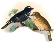
175:Damar flycatcher; 1901 illustration by
116:and 200 km (124 mi.) east of
68:province, on the southern side of the
250:
248:
242:Badan Pusat Statistik, Jakarta, 2024.
233:Badan Pusat Statistik, Jakarta, 2021.
7:
602:
600:
620:. You can help Knowledge (XXG) by
14:
682:Maluku (province) geography stubs
672:Important Bird Areas of Indonesia
612:This article about a location in
604:
211:
88:, tiny 'Nil Desperandum' islet,
260:Important Bird Areas factsheet
1:
677:Populated places in Indonesia
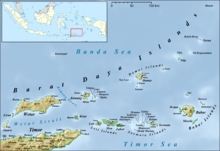
23:Map of the Barat Daya Islands
16:Island in Maluku, Indonesia
698:
599:
289:Global Volcanism Program
190:because it supports the
293:Smithsonian Institution
184:BirdLife International
179:
177:John Gerrard Keulemans
47:
32:
24:
583:7.14167°S 128.61250°E
174:
94:Maluku Tengah Regency
30:
22:
78:Lesser Sunda Islands
588:-7.14167; 128.61250
579: /
188:Important Bird Area
167:Important Bird Area
667:Barat Daya Islands
180:
58:Barat Daya Islands
33:
25:
629:
628:
562:
561:
74:Maluku Barat Daya
689:
650:
643:
636:
608:
601:
594:
593:
591:
590:
589:
584:
580:
577:
576:
575:
572:
333:
326:
319:
310:
303:
302:
300:
299:
281:
275:
274:
272:
271:
266:on July 10, 2007
252:
243:
240:
234:
231:
221:
216:
215:
201:forest habitat.
195:Damar flycatcher
697:
696:
692:
691:
690:
688:
687:
686:
657:
656:
655:
654:
614:Maluku Province
597:
587:
585:
581:
578:
573:
570:
568:
566:
565:
563:
558:
411:Maluku province
405:
342:
337:
307:
306:
297:
295:
283:
282:
278:
269:
267:
254:
253:
246:
241:
237:
232:
228:
217:
210:
207:
169:
126:dryland farming
110:
102:stratovolcanoes
17:
12:
11:
5:
695:
693:
685:
684:
679:
674:
669:
659:
658:
653:
652:
645:
638:
630:
627:
626:
609:
560:
559:
557:
556:
551:
546:
541:
536:
531:
526:
521:
516:
511:
506:
501:
496:
491:
486:
481:
476:
471:
466:
461:
456:
451:
446:
441:
436:
431:
426:
421:
415:
413:
407:
406:
404:
403:
398:
393:
388:
383:
378:
373:
368:
363:
358:
352:
350:
344:
343:
340:Maluku Islands
338:
336:
335:
328:
321:
313:
305:
304:
276:
244:
235:
225:
224:
223:
222:
219:Islands portal
206:
203:
168:
165:
109:
106:
56:island in the
15:
13:
10:
9:
6:
4:
3:
2:
694:
683:
680:
678:
675:
673:
670:
668:
665:
664:
662:
651:
646:
644:
639:
637:
632:
631:
625:
623:
619:
615:
610:
607:
603:
598:
595:
592:
555:
552:
550:
547:
545:
542:
540:
537:
535:
532:
530:
527:
525:
522:
520:
517:
515:
512:
510:
507:
505:
502:
500:
497:
495:
492:
490:
487:
485:
482:
480:
477:
475:
472:
470:
467:
465:
462:
460:
457:
455:
452:
450:
447:
445:
442:
440:
437:
435:
432:
430:
427:
425:
422:
420:
417:
416:
414:
412:
408:
402:
399:
397:
394:
392:
389:
387:
384:
382:
379:
377:
374:
372:
369:
367:
364:
362:
359:
357:
354:
353:
351:
349:
345:
341:
334:
329:
327:
322:
320:
315:
314:
311:
294:
290:
286:
280:
277:
265:
261:
257:
256:"Pulau Damar"
251:
249:
245:
239:
236:
230:
227:
220:
214:
209:
204:
202:
200:
196:
193:
189:
185:
178:
173:
166:
164:
162:
161:stratovolcano
159:
155:
154:Mount Wurlali
151:
147:
143:
139:
135:
131:
127:
123:
119:
115:
107:
105:
103:
99:
95:
91:
87:
83:
79:
75:
71:
67:
63:
59:
55:
51:
50:
45:
41:
37:
31:Mount Wurlali
29:
21:
622:expanding it
611:
596:
564:
453:
348:North Maluku
296:. Retrieved
288:
279:
268:. Retrieved
264:the original
259:
238:
229:
181:
138:coffee beans
111:
98:Manuk Island
90:Serua Island
48:
39:
35:
34:
586: /
574:128°36′45″E
142:cocoa beans
108:Description
86:Nila Island
82:Teon Island
49:Pulau Damer
661:Categories
571:07°08′30″S
298:2014-03-12
270:2014-03-12
205:References
44:Indonesian
514:Nusa Laut
361:Halmahera
285:"Wurlali"
199:evergreen
158:andesitic
70:Banda Sea
62:Indonesia
60:group in
549:Watubela
539:Tanimbar
130:coconuts
54:volcanic
544:Tayandu
524:Saparua
419:Ambelau
396:Ternate
381:Morotai
192:endemic
150:nutmegs
134:cashews
122:cleared
519:Romang
494:Manipa
474:Kelang
464:Haruku
459:Gorong
401:Tidore
376:Makian
186:as an
146:cloves
114:Romang
66:Maluku
616:is a
554:Wetar
534:Serua
529:Seram
499:Manuk
489:Liran
479:Kisar
454:Damar
449:Banda
444:Babar
434:Boano
424:Ambon
366:Kayoa
356:Bacan
156:, an
118:Wetar
40:Damar
38:, or
36:Damer
618:stub
509:Nila
484:Leti
439:Buru
391:Sula
371:Moti
148:and
124:for
504:Moa
469:Kai
429:Aru
386:Obi
128:of
64:'s
42:, (
663::
291:.
287:.
258:.
247:^
144:,
140:,
136:,
132:,
96:-
84:,
46::
649:e
642:t
635:v
624:.
332:e
325:t
318:v
301:.
273:.
Text is available under the Creative Commons Attribution-ShareAlike License. Additional terms may apply.