286:
217:
205:
193:
28:
168:
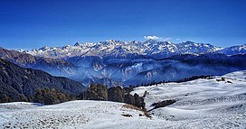
In spring, there is contrast of greenery of the grasslands and red and pink rhododendrons. In winters, the Bugyal turns into snow land with capability of skiing and snow activities. The trek is open throughout the year except the monsoon. Views of the
Garhwal Himalayas, including
331:
350:
355:
360:
365:
60:
324:
216:
317:
53:
138:
100:
192:
285:
301:
204:
269:
241:
153:
destination. The Bugyal has an average elevation of 3639m and is around 40 km from
158:
115:
344:
178:
162:
255:
297:
174:
142:
104:
170:
154:
75:
62:
27:
146:
122:
150:
134:
43:
293:
108:
305:
114:
96:
91:
52:
42:
37:
20:
325:
8:
332:
318:
292:This article related to a location in the
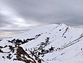
222:Dayara Bugyal Grasslands covered with snow
17:
233:
188:
157:. Dayara Bugyal is nestled between the
165:trees and is rich in flora and fauna.
7:
282:
280:
304:. You can help Knowledge (XXG) by
181:, can be seen from Dayara Bugyal.
14:
351:Montane grasslands and shrublands
137:(Himalayan Alpine Meadow) in the
356:Geography of Uttarkashi district
284:
215:
203:
191:
26:
1:
145:. Dayara Bugyal is a popular
48:3,639 m (11,939 ft)
361:Hiking trails in Uttarakhand
366:Uttarakhand geography stubs
382:
279:
76:30.8383656°N 78.5550349°E
25:
81:30.8383656; 78.5550349
244:. Uttarkashi.nic.in.
272:. euttaranchal.com.
139:Uttarkashi district
101:Uttarkashi district
72: /
38:Highest point
313:
312:
258:. indiahikes.com.
128:
127:
373:
334:
327:
320:
288:
281:
274:
273:
266:
260:
259:
252:
246:
245:
238:
219:
207:
195:
123:Garhwal Himalaya
118:
87:
86:
84:
83:
82:
77:
73:
70:
69:
68:
65:
30:
18:
381:
380:
376:
375:
374:
372:
371:
370:
341:
340:
339:
338:
278:
277:
270:"Dayara Bugyal"
268:
267:
263:
256:"Dayara Bugyal"
254:
253:
249:
242:"Dayara Bugyal"
240:
239:
235:
230:
223:
220:
211:
208:
199:
196:
187:
116:
80:
78:
74:
71:
66:
63:
61:
59:
58:
33:
12:
11:
5:
379:
377:
369:
368:
363:
358:
353:
343:
342:
337:
336:
329:
322:
314:
311:
310:
289:
276:
275:
261:
247:
232:
231:
229:
226:
225:
224:
221:
214:
212:
209:
202:
200:
198:Dayara Bugyal]
197:
190:
186:
183:
126:
125:
120:
112:
111:
98:
94:
93:
89:
88:
56:
50:
49:
46:
40:
39:
35:
34:
31:
23:
22:
13:
10:
9:
6:
4:
3:
2:
378:
367:
364:
362:
359:
357:
354:
352:
349:
348:
346:
335:
330:
328:
323:
321:
316:
315:
309:
307:
303:
299:
295:
290:
287:
283:
271:
265:
262:
257:
251:
248:
243:
237:
234:
227:
218:
213:
206:
201:
194:
189:
184:
182:
180:
176:
172:
166:
164:
160:
156:
152:
148:
144:
140:
136:
132:
131:Dayara Bugyal
124:
121:
119:
113:
110:
106:
102:
99:
95:
90:
85:
57:
55:
51:
47:
45:
41:
36:
32:Dayara Bugyal
29:
24:
21:Dayara Bugyal
19:
16:
306:expanding it
291:
264:
250:
236:
179:Swargarohini
167:
163:Rhododendron
130:
129:
117:Parent range
15:
298:Uttarakhand
175:Bandarpunch
143:Uttarakhand
105:Uttarakhand
79: /
54:Coordinates
345:Categories
228:References
171:Nanda Devi
155:Uttarkashi
67:78°33′18″E
64:30°50′18″N
296:state of
92:Geography
44:Elevation
147:trekking
97:Location
185:Gallery
151:camping
294:Indian
210:Summit
159:Deodar
135:Bugyal
300:is a
133:is a
109:India
302:stub
177:and
161:and
149:and
141:of
347::
173:,
107:,
103:,
333:e
326:t
319:v
308:.
Text is available under the Creative Commons Attribution-ShareAlike License. Additional terms may apply.
![Dayara Bugyal]](https://upload.wikimedia.org/wikipedia/commons/thumb/3/39/Dayara_Bugyal.jpg/120px-Dayara_Bugyal.jpg)