332:
40:
331:
338:
372:
368:
487:
565:
268:, 'island shaped like a down (i.e. a hill with a rounded profile)'. It gives its name to the Denny Island Fault Zone, a part of the Avon-Solent
295:
570:
580:
233:
165:
71:
462:
280:
575:
585:
494:
283:. 23 years later, on the 21st of September 2018, he slept overnight on the island to raise money for the maintenance of the
161:
520:
264:, in the charter recording the creation of the county of Bristol in 1373. This suggests that the name means, in
220:
known as the Welsh
Grounds. Its foreshore area changes dramatically according to the state of the tide, because
409:
Kellaway, G.A. (1996). "Discovery of the Avon-Solent
Fracture Zone and its relationship to Bath hot springs".
288:
284:
24:
525:
276:
205:
310:
418:
209:
20:
229:
198:
186:
346:
225:
174:
153:
59:
559:
269:
190:
128:
294:
In 2004, the island was subject to an unsuccessful appeal under
Section 6(1) of the
39:
550:
436:
318:
265:
194:
232:
are amongst the highest in the world, reaching 13.7 m (45 ft) at the
322:
86:
73:
241:
213:
422:
342:
302:
217:
314:
245:
178:
249:
170:
260:
Denny Island appears in the historical record for the first time as
23:, Somerset, see that page. For the island in British Columbia, see
306:
221:
182:
237:
463:"Portishead man to spend night alone on island for lighthouse"
173:
of 0.24 hectares (0.6 acres), with scrub vegetation, in the
177:. Its rocky southern foreshore marks the boundary between
369:"Bristol City Council - Beating Bristol's water boundary"
298:
against it appearing on a map of registered common land.
197:. The island also marks the north-western limit of the
493:. Planning Inspectorate. November 2004. Archived from
279:
spent 3 nights on Denny Island to raise money for the
139:
134:
124:
110:
102:
65:
55:
50:
16:Uninhabited island off the shores of Great Britain
204:It is located approximately three miles north of
313:, some of which was used as nesting material by
275:On the 21st of September 1995, Neil Carter from
551:Images of Denny Island from www.geograph.co.uk
309:claimed to have discovered a large amount of
189:, the island is reckoned administratively to
8:
32:
31:
201:'s water boundary in the Severn estuary.
360:
296:Countryside and Rights of Way Act 2000
236:. It is known as a nesting-place for
521:"Explosive discovery at Denny Island"
106:2,400 m (26,000 sq ft)
7:
396:Bristol charters, 1155-1373 p 154-5
14:
461:Jones, Liam (19 September 2018).
519:Chown, Jake (22 November 2017).
330:
216:in England. It is surrounded by
38:
248:, which are regularly seen and
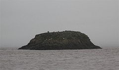
169:) is a small uninhabited rocky
566:Islands of the Bristol Channel
301:On the 13th of November 2017,
1:
325:after visiting Denny Island.
571:Uninhabited islands of Wales
394:Harding, N. Dermott (1930).
581:Islands of the River Severn
289:Black Nore Lighthouse Trust
602:
18:
398:. Bristol Record Society.
115:
46:
37:
576:Islands of Monmouthshire
467:NorthSomersetTimes.co.uk
19:For the small island in
586:River islands of Wales
157:
423:10.1007/s002540050076
411:Environmental Geology
285:Black Nore Lighthouse
25:Denny Island (Canada)
526:Monmouthshire Beacon
437:"About Denny Island"
87:51.52578°N 2.78091°W
500:on 13 December 2007
441:VisitPortishead.net
341:Denny Island and a
83: /
34:
375:on 12 October 2007
303:Lave net fishermen
92:51.52578; -2.78091
488:"Appeal Decision"
345:as seen from the
208:, midway between
147:
146:
593:
538:
537:
535:
533:
516:
510:
509:
507:
505:
499:
492:
484:
478:
477:
475:
473:
458:
452:
451:
449:
447:
433:
427:
426:
406:
400:
399:
391:
385:
384:
382:
380:
371:. Archived from
365:
334:
168:
98:
97:
95:
94:
93:
88:
84:
81:
80:
79:
76:
42:
35:
21:Chew Valley Lake
601:
600:
596:
595:
594:
592:
591:
590:
556:
555:
547:
542:
541:
531:
529:
518:
517:
513:
503:
501:
497:
490:
486:
485:
481:
471:
469:
460:
459:
455:
445:
443:
435:
434:
430:
408:
407:
403:
393:
392:
388:
378:
376:
367:
366:
362:
357:
352:
351:
350:
340:
335:
258:
230:Bristol Channel
199:City of Bristol
187:high water mark
164:
120:
91:
89:
85:
82:
77:
74:
72:
70:
69:
28:
17:
12:
11:
5:
599:
597:
589:
588:
583:
578:
573:
568:
558:
557:
554:
553:
546:
545:External links
543:
540:
539:
511:
479:
453:
428:
401:
386:
359:
358:
356:
353:
347:North Somerset
337:
336:
329:
328:
327:
321:, and several
317:, a bomb from
257:
254:
234:spring equinox
175:Severn Estuary
162:grid reference
145:
144:
141:
137:
136:
132:
131:
126:
125:County Council
122:
121:
116:
113:
112:
111:Administration
108:
107:
104:
100:
99:
67:
63:
62:
60:Severn Estuary
57:
53:
52:
48:
47:
44:
43:
15:
13:
10:
9:
6:
4:
3:
2:
598:
587:
584:
582:
579:
577:
574:
572:
569:
567:
564:
563:
561:
552:
549:
548:
544:
528:
527:
522:
515:
512:
496:
489:
483:
480:
468:
464:
457:
454:
442:
438:
432:
429:
424:
420:
416:
412:
405:
402:
397:
390:
387:
374:
370:
364:
361:
354:
348:
344:
339:
333:
326:
324:
320:
316:
312:
308:
304:
299:
297:
292:
290:
286:
282:
278:
273:
271:
270:Fracture zone
267:
263:
255:
253:
251:
247:
243:
239:
235:
231:
227:
223:
219:
215:
212:in Wales and
211:
207:
202:
200:
196:
192:
191:Monmouthshire
188:
184:
180:
176:
172:
167:
163:
159:
155:
151:
142:
138:
133:
130:
129:Monmouthshire
127:
123:
119:
114:
109:
105:
101:
96:
68:
64:
61:
58:
54:
49:
45:
41:
36:
30:
26:
22:
530:. Retrieved
524:
514:
502:. Retrieved
495:the original
482:
470:. Retrieved
466:
456:
444:. Retrieved
440:
431:
414:
410:
404:
395:
389:
377:. Retrieved
373:the original
363:
323:cannon balls
300:
293:
274:
261:
259:
203:
150:Denny Island
149:
148:
135:Demographics
117:
33:Denny Island
29:
417:(1): 34–9.
266:Old English
195:South Wales
90: /
66:Coordinates
560:Categories
532:19 January
472:19 January
446:19 January
355:References
277:Portishead
244:and other
242:cormorants
206:Portishead
158:Ynys Denny
140:Population
75:51°31′33″N
218:sandbanks
214:Avonmouth
78:2°46′51″W
51:Geography
379:10 March
343:sailboat
315:seabirds
246:seabirds
185:. Above
166:ST459810
56:Location
311:plastic
287:by the
256:History
252:there.
226:estuary
224:in the
210:Redwick
179:England
504:21 May
250:ringed
171:island
498:(PDF)
491:(PDF)
349:coast
307:Wales
305:from
262:Dunye
238:gulls
222:tides
183:Wales
154:Welsh
118:Wales
534:2024
506:2007
474:2024
448:2024
381:2009
281:RNLI
228:and
181:and
103:Area
419:doi
319:WW2
562::
523:.
465:.
439:.
415:28
413:.
291:.
272:.
240:,
193:,
160:;
156::
536:.
508:.
476:.
450:.
425:.
421::
383:.
152:(
143:0
27:.
Text is available under the Creative Commons Attribution-ShareAlike License. Additional terms may apply.