245:
260:
611:
215:
230:
80:
makes the boundary between North and East Sikkim, and ultimately plunges into the river Tista near Dikchu. The Range Chola extends further south for 20 kilometre along the eastern boundary of East Sikkim and acts as the water-divide between Rangpo-De chhu valleys lying in the district and Ammo chhu in Tibet..... De chhu excavates a narrow valley in south-eastern portion of the area, cuts deeply the last tip of Chola Range and ultimately flows southward through a glen to mark the boundary between
Darjiling district and Bhutan.
79:
From
Pauhunri emanates a large thrust, Dongkiya Range which strides southward for about 50 kilometre. It is separated from Tsen-gui kang by a fracturing belt of the Lachung chhu valley and leans over the Chola Range just north of Cho la (4435m).... The stream Rate chhu originates near Cho la which
244:
214:
259:
229:
140:
comment that while
Dongkya Range is politically important, "but from a Himalayan point of view too great a topographical emphasis was given to them upon maps".
648:
575:
397:
477:. Delhi: Manager of Publications. Sold at the Office of the Geodetic Branch, Survey of India, Dehra Dun. p. 213 – via Internet Archive.
504:
433:
326:
236:
641:
355:
610:
672:
667:
634:
266:
159:
52:
386:
122:
525:
98:
460:
129:
464:
133:
540:
500:
429:
423:
367:
322:
251:
221:
468:
137:
618:
32:
494:
661:
94:
559:
563:
316:
447:
341:
114:
102:
154:
106:
44:
590:
577:
544:
371:
499:. Internet Archive. Union City, CA : Heian International. p. 201.
472:
121:
plateau at the southern end gives rise to complications and the present day
36:
187:
174:
168:
110:
60:
56:
474:
A Sketch of the
Geography and Geology of Himalaya Mountains and Tibet
118:
90:
40:
387:"India, China and the Nathu La: Converting Symbolism into Reality"
617:
This Asia mountain, mountain range, or peak related article is a
356:"Endemic and Threatened Orchids of Sikkim and Their Conservation"
422:
Singh, Vijay P.; Singh, Pratap; Haritashya, Umesh K. (2011),
366:(1: Special Habitats and Threatened Plants of India): 63–67.
318:
Human
Ecology of Sikkim: A Case Study of Upper Rangit Basin
47:, and as it moves southwards, sometimes referred to as the
533:
Indian
Journal of Landscape Systems and Ecological Studies
109:. The Convention deemed the Dongkya Range to end at Mount
73:
Indian
Journal of Landscape Systems and Ecological Studies
622:
448:
Samanta, Geomorphic Units of The Sikkim
Himalaya (2019)
342:
Samanta, Geomorphic Units of The Sikkim
Himalaya (2019)
428:, Springer Science & Business Media, p. 518,
128:Dongkya Range is politically important, however
43:, a state of India. Its northern tip extends to
77:
113:at the southern end, which was defined as the
642:
117:between India, Tibet and Bhutan. However the
8:
565:The Face of the Earth: Das Antlitz Der Erde
360:ENVIS Bulletin: Wildlife and Protected Area
649:
635:
526:"Geomorphic Units of The Sikkim Himalaya"
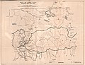
220:1898 Sikhim and Adjoining Territories by
89:It was established as the border between
307:
284:
210:
524:Samanta, Samir Kumar (December 2019).
425:Encyclopedia of Snow, Ice and Glaciers
321:. Gyan Publishing House. p. 65.
7:
607:
605:
488:
486:
484:
403:from the original on 30 October 2021
14:
385:Wangchuk, Pema (1 January 2013).
39:that forms the eastern border of
609:
258:
243:
228:
213:
16:Mountain range in the Himalayas
291:Alternative spellings include
71:S. K. Samanta explains in the
1:
67:Dongkya range and Chola range
621:. You can help Knowledge by
315:Gulia, Kuldip Singh (2005).
267:Central Intelligence Agency
193:Kangchengyao (6,889 meters)
689:
604:
202:Dopendikang (5,359 meters)
196:Gurudongmar (6,715 meters)
125:between Bhutan and China.
496:Trekking in the Himalayas
199:Chugalung (5,759 meters)
493:Iozawa, Tomoya (1985).
461:Burrard, Sidney Gerald
354:Lucksom, S.Z. (2008).
99:Convention of Calcutta
82:
465:Hayden, Henry Hubert
274:References and notes
165:Yak La (Chola range)
85:Political importance
673:Asia mountain stubs
668:Mountains of Sikkim
587: /
568:. Clarendon Press.
630:
629:
591:27.683°N 88.833°E
506:978-0-89346-212-3
435:978-90-481-2642-2
328:978-81-7835-325-8
680:
651:
644:
637:
613:
606:
602:
601:
599:
598:
597:
592:
588:
585:
584:
583:
580:
569:
548:
530:
511:
510:
490:
479:
478:
469:Heron, Alexander
457:
451:
445:
439:
438:
419:
413:
412:
410:
408:
402:
391:
382:
376:
375:
351:
345:
339:
333:
332:
312:
295:
289:
262:
252:Army Map Service
247:
237:William O'Connor
232:
222:Laurence Waddell
217:
144:Passes and peaks
101:reached between
688:
687:
683:
682:
681:
679:
678:
677:
658:
657:
656:
655:
595:
593:
589:
586:
581:
578:
576:
574:
573:
558:
555:
553:Further reading
528:
523:
515:
514:
507:
492:
491:
482:
459:
458:
454:
450:, pp. 152.
446:
442:
436:
421:
420:
416:
406:
404:
400:
389:
384:
383:
379:
353:
352:
348:
344:, pp. 148.
340:
336:
329:
314:
313:
309:
299:
298:
290:
286:
276:
269:
263:
254:
248:
239:
233:
224:
218:
209:
184:
151:
146:
87:
69:
51:, it is cut by
17:
12:
11:
5:
686:
684:
676:
675:
670:
660:
659:
654:
653:
646:
639:
631:
628:
627:
614:
596:27.683; 88.833
571:
570:
554:
551:
550:
549:
520:
519:
513:
512:
505:
480:
452:
440:
434:
414:
377:
346:
334:
327:
306:
305:
304:
303:
297:
296:
283:
282:
281:
280:
275:
272:
271:
270:
264:
257:
255:
249:
242:
240:
234:
227:
225:
219:
212:
208:
205:
204:
203:
200:
197:
194:
191:
190:(7,128 meters)
183:
180:
179:
178:
172:
166:
163:
157:
150:
147:
145:
142:
123:border dispute
86:
83:
68:
65:
33:mountain range
26:Dongkhya range
15:
13:
10:
9:
6:
4:
3:
2:
685:
674:
671:
669:
666:
665:
663:
652:
647:
645:
640:
638:
633:
632:
626:
624:
620:
615:
612:
608:
603:
600:
567:
566:
561:
560:Suess, Eduard
557:
556:
552:
546:
542:
538:
534:
527:
522:
521:
517:
516:
508:
502:
498:
497:
489:
487:
485:
481:
476:
475:
470:
466:
462:
456:
453:
449:
444:
441:
437:
431:
427:
426:
418:
415:
399:
395:
388:
381:
378:
373:
369:
365:
361:
357:
350:
347:
343:
338:
335:
330:
324:
320:
319:
311:
308:
301:
300:
294:
288:
285:
278:
277:
273:
268:
261:
256:
253:
246:
241:
238:
231:
226:
223:
216:
211:
206:
201:
198:
195:
192:
189:
186:
185:
181:
177:(Chola range)
176:
173:
171:(Chola range)
170:
167:
164:
162:(Chola range)
161:
158:
156:
153:
152:
148:
143:
141:
139:
135:
131:
130:S. G. Burrard
126:
124:
120:
116:
112:
108:
104:
103:British India
100:
96:
95:Chumbi Valley
92:
84:
81:
76:
74:
66:
64:
62:
58:
54:
50:
46:
42:
38:
34:
30:
27:
23:
19:
623:expanding it
616:
572:
564:
536:
532:
518:Bibliography
495:
473:
455:
443:
424:
417:
405:. Retrieved
394:www.ipcs.org
393:
380:
363:
359:
349:
337:
317:
310:
292:
287:
134:H. H. Hayden
127:
97:by the 1890
93:and Tibet's
88:
78:
72:
70:
48:
28:
25:
21:
20:
18:
594: /
265:1965 by US
250:1955 by US
115:trijunction
49:Chola range
662:Categories
539:(2): 148.
155:Dongkha La
107:Qing China
55:, Yak La,
45:Dongkha La
545:0971-4170
372:0972-088X
302:Citations
182:Mountains
37:Himalayas
562:(1904).
471:(1933).
407:28 March
398:Archived
293:Dongkiya
235:1903 by
188:Pauhunri
175:Jelep La
169:Nathu La
138:A. Heron
111:Gipmochi
63:passes.
61:Jelep La
57:Nathu La
582:88°50′E
579:27°41′N
396:(PDF).
207:Gallery
35:in the
22:Dongkya
543:
503:
432:
370:
325:
160:Cho La
149:Passes
119:Doklam
91:Sikkim
53:Cho La
41:Sikkim
529:(PDF)
401:(PDF)
390:(PDF)
279:Notes
31:is a
619:stub
541:ISSN
501:ISBN
430:ISBN
409:2021
368:ISSN
323:ISBN
136:and
105:and
59:and
24:or
664::
537:42
535:.
531:.
483:^
467:;
463:;
392:.
364:11
362:.
358:.
132:,
75:,
650:e
643:t
636:v
625:.
547:.
509:.
411:.
374:.
331:.
29:,
Text is available under the Creative Commons Attribution-ShareAlike License. Additional terms may apply.