78:
20:
228:
77:
65:
that forces the water upward. The powerful incoming tidal current loops back and collides with itself while another current, coursing in semicircular fashion around
155:
218:
19:
61:, but rather from the collision of three opposed tidal currents whose violence is enhanced by the presence of a subsurface
126:
179:
142:
66:
159:
130:
223:
145:; Worldwide Tide Forecast website (enter country, then location); accessed October 2015
212:
36:
40:
102:
51:
44:
90:
194:
181:
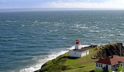
121:
58:
156:""Cape d'Or Lighthouse" at Nova Scotia Lighthouse Preservation Society"
86:
62:
32:
93:, which is still operational, was established in 1922.
69:, slams into the collision point at a 90-degree angle.
229:
Tourist attractions in
Cumberland County, Nova Scotia
81:
Diagram showing the currents creating the Dory Rips
54:, which is known for the globe's highest tides.
23:Cape d'Or lighthouse overlooking the Dory Rips
57:The turbulence does not result from a simple
50:The phenomenon occurs at the entrance to the
8:
85:To warn mariners away from the Dory Rips, a
133:at Central Nova Scotia Tourism Association
76:
18:
114:
89:was placed at Cape d'Or in 1875 and a
7:
35:agitation of waters located in the
31:is a phenomenon involving extreme
14:
16:Extreme tidal agitation of waters
1:
245:
219:Headlands of Nova Scotia
143:"High/Low Tidal Finder"
195:45.29083°N 64.774306°W
82:
24:
80:
22:
200:45.29083; -64.774306
39:off the headland of
191: /
45:Nova Scotia, Canada
129:2014-09-23 at the
83:
25:
236:
206:
205:
203:
202:
201:
196:
192:
189:
188:
187:
184:
171:
170:
168:
167:
158:. Archived from
152:
146:
140:
134:
119:
244:
243:
239:
238:
237:
235:
234:
233:
209:
208:
199:
197:
193:
190:
185:
182:
180:
178:
177:
175:
174:
165:
163:
154:
153:
149:
141:
137:
131:Wayback Machine
120:
116:
111:
99:
75:
17:
12:
11:
5:
242:
240:
232:
231:
226:
221:
211:
210:
173:
172:
147:
135:
113:
112:
110:
107:
106:
105:
98:
95:
74:
71:
15:
13:
10:
9:
6:
4:
3:
2:
241:
230:
227:
225:
222:
220:
217:
216:
214:
207:
204:
162:on 2014-11-02
161:
157:
151:
148:
144:
139:
136:
132:
128:
125:
124:
118:
115:
108:
104:
101:
100:
96:
94:
92:
88:
79:
73:Marine Hazard
72:
70:
68:
64:
60:
55:
53:
48:
46:
42:
38:
34:
30:
21:
186:64°46′27.5″W
176:
164:. Retrieved
160:the original
150:
138:
122:
117:
84:
67:Advocate Bay
56:
49:
37:Bay of Fundy
28:
26:
198: /
103:Rip current
52:Minas Basin
213:Categories
183:45°17′27″N
166:2014-11-02
109:References
91:lighthouse
41:Cape d'Or
29:Dory Rips
127:Archived
97:See also
59:rip tide
87:foghorn
224:Tides
123:Tides
33:tidal
63:reef
27:The
43:in
215::
47:.
169:.
Text is available under the Creative Commons Attribution-ShareAlike License. Additional terms may apply.