46:
381:
33:
268:
53:
263:
In 1949, construction of the
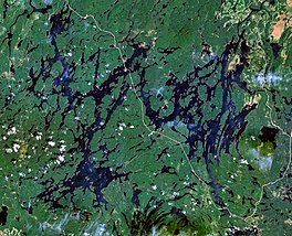
Bourque Dam began on the Ottawa River, forming Dozois Reservoir. The rising waters flooded numerous smaller lakes, including Lake Soulier, Déléage Bay, and Lake Dozois. The reservoir took its name from Lake Dozois, which in turn was named after Nazaire-Servule Dozois
264:(1859-1932), missionary in Témiscamingue and Assistant General of the Oblates from 1904 to 1932. The name Lake Dozois has been in use since circa 1913, when it replaced "Birch Lake" which appeared on the map of Quebec in 1911.
350:
422:
78:
451:
415:
96:
293:
354:
441:
408:
45:
251:
and about 15 km east of Great
Victoria Lake, is fed by the Chochocouane, Capitachouane, and Ottawa Rivers. It is accessible directly off
241:
446:
297:
334:
388:
332:
Ottawa River
Regulation Planning Board - Principal Reservoirs Current Water Levels and System Constraints
154:
237:
74:
17:
140:
305:
248:
392:
272:
252:
338:
318:
221:
168:
435:
128:
32:
161:
147:
380:
267:
111:
98:
133:
141:
331:
155:
233:
229:
82:
266:
210:
336.80 m (1,105.0 ft) to 345.95 m (1,135.0 ft)
353:(in French). Commission de toponymie du Québec. Archived from
396:
247:
Dozois
Reservoir, located about 10 kilometers west of
206:
198:
190:
182:
178:
167:
153:
139:
127:
88:
70:
25:
236:. It is fully within the unorganized territory of
89:
79:La Vallée-de-l'Or Regional County Municipality
416:
8:
423:
409:
298:Hydro-Quebec Dozois Reservoir the original
22:
52:
285:
314:
303:
452:Abitibi-Témiscamingue geography stubs
7:
377:
375:
16:For the unorganized territory, see
395:. You can help Knowledge (XXG) by
14:
294:"Hydro-Québec - Dozois reservoir"
202:319 km (123 sq mi)
379:
296:. March 28, 2006. Archived from
228:) is a man-made lake in central
51:
44:
31:
205:
197:
189:
181:
442:Lakes of Abitibi-Témiscamingue
1:
242:La Vérendrye Wildlife Reserve
69:
468:
374:
15:
39:
30:
194:34 km (21 mi)
186:61 km (38 mi)
391:location article is a
276:
225:
389:Abitibi-Témiscamingue
270:
112:47.50000°N 77.08333°W
447:Reservoirs in Quebec
271:Reservoir Dozois at
117:47.50000; -77.08333
108: /
351:"Réservoir Dozois"
337:2008-12-05 at the
277:
404:
403:
249:Cabonga Reservoir
214:
213:
207:Surface elevation
459:
425:
418:
411:
383:
376:
366:
365:
363:
362:
347:
341:
329:
323:
322:
316:
311:
309:
301:
290:
273:Quebec Route 117
253:Quebec Route 117
238:Réservoir-Dozois
226:Réservoir Dozois
218:Dozois Reservoir
157:
156:Primary outflows
143:
123:
122:
120:
119:
118:
113:
109:
106:
105:
104:
101:
91:
75:Réservoir-Dozois
59:Dozois Reservoir
55:
54:
48:
35:
26:Dozois Reservoir
23:
18:Réservoir-Dozois
467:
466:
462:
461:
460:
458:
457:
456:
432:
431:
430:
429:
372:
370:
369:
360:
358:
349:
348:
344:
339:Wayback Machine
330:
326:
312:
302:
292:
291:
287:
282:
261:
171: countries
142:Primary inflows
116:
114:
110:
107:
102:
99:
97:
95:
94:
66:
65:
64:
63:
62:
61:
60:
56:
21:
12:
11:
5:
465:
463:
455:
454:
449:
444:
434:
433:
428:
427:
420:
413:
405:
402:
401:
384:
368:
367:
342:
324:
300:on 2006-03-28.
284:
283:
281:
278:
260:
257:
212:
211:
208:
204:
203:
200:
196:
195:
192:
188:
187:
184:
180:
179:
176:
175:
172:
165:
164:
159:
151:
150:
145:
137:
136:
131:
125:
124:
92:
86:
85:
72:
68:
67:
58:
57:
50:
49:
43:
42:
41:
40:
37:
36:
28:
27:
13:
10:
9:
6:
4:
3:
2:
464:
453:
450:
448:
445:
443:
440:
439:
437:
426:
421:
419:
414:
412:
407:
406:
400:
398:
394:
390:
385:
382:
378:
373:
357:on 2016-03-03
356:
352:
346:
343:
340:
336:
333:
328:
325:
320:
307:
299:
295:
289:
286:
279:
274:
269:
265:
258:
256:
254:
250:
245:
243:
239:
235:
231:
227:
223:
219:
209:
201:
193:
185:
177:
173:
170:
166:
163:
160:
158:
152:
149:
146:
144:
138:
135:
132:
130:
126:
121:
93:
87:
84:
80:
76:
73:
47:
38:
34:
29:
24:
19:
397:expanding it
386:
371:
359:. Retrieved
355:the original
345:
327:
288:
262:
246:
217:
215:
199:Surface area
162:Ottawa River
148:Ottawa River
183:Max. length
115: /
90:Coordinates
436:Categories
361:2008-11-13
315:|url=
280:References
191:Max. width
134:Artificial
103:77°05′00″W
100:47°30′00″N
335:Archived
306:cite web
240:and the
71:Location
317:value (
259:History
313:Check
234:Canada
230:Quebec
222:French
174:Canada
83:Quebec
387:This
169:Basin
393:stub
319:help
216:The
129:Type
438::
310::
308:}}
304:{{
255:.
244:.
232:,
224::
81:,
77:,
424:e
417:t
410:v
399:.
364:.
321:)
275:.
220:(
20:.
Text is available under the Creative Commons Attribution-ShareAlike License. Additional terms may apply.