23:
317:
100:
306:
329:
657:
and even capture the upper Danube and its surface tributaries. It is expected that the Danube's upper course will one day disappear entirely in favour of the Rhine ("
688:
492:
670:
456:
641:
created the river Rhine. The Rhine's sharper altitude gradient on its much shorter way to the North Sea causes much stronger
544:
1072:
1004:
198:
tributaries. The
European watershed meets the Atlantic-North Sea Continental Divide at the triple point between the
17:
1077:
680:
1082:
266:
857:
488:
575:
603:
22:
551:
1011:(Main drainage basins of the world's rivers). UN Global Compact CEO Water Mandate. Archived from
675:
270:
578:. Then, the Watershed goes northeast near the Poland–Ukraine border, passes through the city of
195:
638:
460:
389:
238:
207:
171:
67:
55:
654:
642:
591:
218:
864:(Map of the drainage basins in France in the 'Zone Hydrographique' dateset). Archived from
316:
595:
464:
452:
75:
35:
922:(Drainage basins in Baden-Würrtemberg in the map 'Basiseinzugsgebiet (AWGN)_polygon.shp')
99:
658:
528:
516:
476:
468:
432:
409:
381:
353:
250:
230:
199:
191:
43:
39:
1066:
650:
555:
393:
278:
167:
123:
112:
360:, between the catchment area of the Rhine, which empties into the North Sea via the
832:
627:
583:
448:
444:
440:
242:
127:
59:
540:
309:
915:
26:
Main
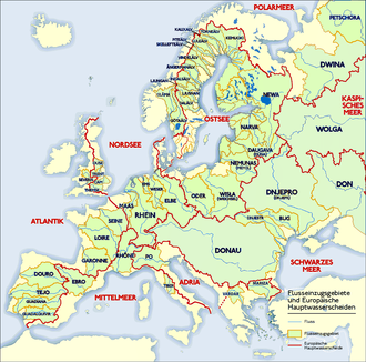
European drainage divides (red lines) separating catchments (green regions).
599:
472:
361:
349:
345:
341:
333:
294:
290:
254:
234:
214:
187:
79:
1041:
890:
536:
397:
282:
274:
258:
51:
1056:
Interactive topographical map of the
European Continental Divide on the site
807:
782:
703:
690:
634:
524:
512:
424:
369:
262:
203:
147:
71:
63:
47:
993:(Drainage basins in Poland in the map 'Wektorowe warstwy tematyczne aPGW').
543:(Trójmorski Wierch). At this point, the European Watershed connects to the
947:(Drainage basins in Bavaria in the map 'EZG25_01_2016_by.shp') (in German)
1012:
611:
607:
567:
428:
377:
246:
151:
131:
108:
587:
571:
563:
559:
496:
480:
436:
417:
413:
405:
401:
385:
373:
321:
305:
221:
it separates the Rhone basin in the southwest from the drainage of the
163:
155:
104:
940:
328:
897:(Drainage basins in Switzerland in the map 'EZGG.sqlite') (in German)
646:
520:
504:
500:
365:
286:
253:, at 4,274 m the high point of the watershed, before dropping to the
159:
83:
732:
865:
357:
315:
304:
226:
222:
183:
179:
175:
139:
135:
119:
98:
21:
1057:
615:
579:
532:
508:
484:
143:
649:). Therefore the Rhine and its tributaries intrude deeper into
858:"Sandre - Portail national d'accès aux référentiels sur l'eau"
757:
566:
basins in the north, reaching the triple point of Poland with
965:
550:
The
Watershed continues in an eastern direction along the
1005:"Interactive Database of the World's River Basins - Home"
990:
312:– one of six places in Europe where three watersheds meet
285:
until it reaches the triple point of the Rhine, Po and
966:"VÚV T.G.Masaryka - Oddělení GIS - O projektu DIBAVOD"
467:, forming the border between Germany and the Austrian
645:than that of the much older River Danube (see the
1009:Interactive Database of the World's River Basins
764:(Map of the drainage basin for the Segura River)
229:in the northeast, turns southwards to the Swiss
103:Atlantic—Mediterranean watershed marker between
941:"Bayerisches Landesamt für Umwelt - LfU Bayern"
789:(Map of the drainage basin for the Jucar River)
598:of Russia, ending at the triple point with the
487:River. It again turns northeastwards along the
273:, the triple watershed of the Rhone, Rhine and
814:(Map of the drainage basin for the River Ebro)
8:
158:, where it again turns to the north through
739:(Drainage basin for the Guadalquivir river)
737:Confederacion Hidrografica del Guadalquivir
920:Landesanstalt für Umwelt Baden-Württemberg
388:massif and forming the border between the
340:The divide continues northwards along the
190:mountain range between the sources of the
368:, which flows eastward emptying into the
590:. Then it runs east-northeast along the
447:. It then follows the main ridge of the
327:
150:. It then follows the main ridge of the
758:"Confederación Hidrográfica del Segura"
724:
626:The watershed is not a clearly defined
545:North Sea–Baltic Sea Continental Divide
610:between the Western Russian cities of
210:at Mount Piémont in Northeast France.
118:The Watershed runs northwards through
122:in the Iberian Peninsula towards the
7:
970:Digitální báze vodohospodářských dat
884:
882:
787:Confederacion Hidrografica del Jucar
289:basins at the "roof of Europe" near
277:rivers. East of here it crosses the
972:(Drainage basins in Czech Republic)
891:"Bundesamt für Umwelt - Startseite"
320:Rhine–Danube watershed marker near
66:. It stretches from the tip of the
1040:volume 27, No. 2, 1996, p. 87–96.
671:Continental Divide of the Americas
142:in the west to the sources of the
42:of the rivers that empty into the
38:("watershed") which separates the
14:
1034:Origin of the Danube-Aach system.
916:"Umwelt-Daten und -Karten Online"
889:UFAM, Bundesamt für Umwelt BAFU.
783:"Descarga de Datos y Cartografía"
162:along the catchment areas of the
503:, where the triple point of the
443:headwaters of the Danube in the
412:and leaves the High Alps at the
812:Confederacion Hidrografica Ebro
1:
637:in the area which is now the
463:and southeastwards along the
539:) is located at the peak of
182:in the west and that of the
435:towards the sources of the
332:European watershed marker (
186:in the east, marked by the
1099:
647:Danube upper river geology
493:Králický Sněžník Mountains
18:Watershed (disambiguation)
15:
459:northeastwards up to the
455:with the crossing of the
54:from those that feed the
681:Category:Drainage basins
483:basin is drained by the
166:(with the summit of the
126:along the basins of the
74:in the southwest to the
862:www.sandre.eaufrance.fr
457:Rhine–Main–Danube Canal
408:, via the crest of the
1042:doi:10.1007/BF01061676
1038:Environmental Geology.
602:drainage basin in the
554:Mountains down to the
337:
325:
313:
115:
95:Atlantic—Mediterranean
27:
1058:continental-divide.eu
733:"IDE/Geoportal - CHG"
594:and continues to the
427:it runs north of the
331:
319:
308:
245:where it crosses the
102:
25:
837:www.iberianature.com
576:Bieszczady Mountains
562:, with the Oder and
558:and uphill into the
384:, running along the
261:before crossing the
1073:Geography of Europe
700: /
604:Sychyovsky District
499:at the border with
281:and runs along the
233:and passes between
676:Continental divide
489:Javořice Highlands
479:, where the large
431:catchment area of
423:Within the Alpine
338:
326:
314:
301:Atlantic—Black Sea
271:Witenwasserenstock
116:
86:in the northeast.
32:European watershed
28:
895:www.bafu.admin.ch
833:"Rivers in Spain"
704:61.467°N 37.767°E
639:Upper Rhine Plain
475:regions with the
461:Fichtel Mountains
241:. It reaches the
208:Mediterranean Sea
172:Seuil de Naurouze
68:Iberian Peninsula
56:Mediterranean Sea
1090:
1078:Drainage divides
1044:
1030:
1024:
1023:
1021:
1020:
1001:
995:
994:
987:
981:
980:
978:
977:
962:
956:
955:
953:
952:
937:
931:
930:
928:
927:
912:
906:
905:
903:
902:
886:
877:
876:
874:
873:
854:
848:
847:
845:
843:
829:
823:
822:
820:
819:
804:
798:
797:
795:
794:
779:
773:
772:
770:
769:
754:
748:
747:
745:
744:
729:
715:
714:
712:
711:
710:
705:
701:
698:
697:
696:
693:
643:headward erosion
592:Belarusian Ridge
265:and joining the
257:, rising to the
219:Vosges Mountains
154:eastwards up to
1098:
1097:
1093:
1092:
1091:
1089:
1088:
1087:
1063:
1062:
1053:
1048:
1047:
1031:
1027:
1018:
1016:
1003:
1002:
998:
989:
988:
984:
975:
973:
964:
963:
959:
950:
948:
939:
938:
934:
925:
923:
914:
913:
909:
900:
898:
888:
887:
880:
871:
869:
856:
855:
851:
841:
839:
831:
830:
826:
817:
815:
806:
805:
801:
792:
790:
781:
780:
776:
767:
765:
762:www.chsegura.es
756:
755:
751:
742:
740:
731:
730:
726:
721:
708:
706:
702:
699:
694:
691:
689:
687:
686:
667:
653:of the Swabian
624:
622:Characteristics
596:Smolensk Oblast
495:of the Eastern
465:Bohemian Forest
453:Franconian Jura
303:
97:
92:
76:endorheic basin
36:drainage divide
20:
12:
11:
5:
1096:
1094:
1086:
1085:
1080:
1075:
1065:
1064:
1061:
1060:
1052:
1051:External links
1049:
1046:
1045:
1025:
996:
991:"Otwarte Dane"
982:
957:
932:
907:
878:
849:
824:
799:
774:
749:
723:
722:
720:
717:
709:61.467; 37.767
684:
683:
678:
673:
666:
663:
659:stream capture
651:phreatic zones
623:
620:
529:Eastern Neisse
477:Czech Republic
433:Lake Constance
382:Silvretta Alps
302:
299:
251:Finsteraarhorn
239:Lake Neuchâtel
231:Jura Mountains
96:
93:
91:
88:
44:Atlantic Ocean
13:
10:
9:
6:
4:
3:
2:
1095:
1084:
1083:Geomorphology
1081:
1079:
1076:
1074:
1071:
1070:
1068:
1059:
1055:
1054:
1050:
1043:
1039:
1035:
1029:
1026:
1015:on 2021-01-30
1014:
1010:
1006:
1000:
997:
992:
986:
983:
971:
967:
961:
958:
946:
945:lfu.bayern.de
942:
936:
933:
921:
917:
911:
908:
896:
892:
885:
883:
879:
868:on 2011-03-07
867:
863:
859:
853:
850:
838:
834:
828:
825:
813:
809:
803:
800:
788:
784:
778:
775:
763:
759:
753:
750:
738:
734:
728:
725:
718:
716:
713:
682:
679:
677:
674:
672:
669:
668:
664:
662:
660:
656:
652:
648:
644:
640:
636:
633:For example,
631:
629:
621:
619:
617:
613:
609:
605:
601:
597:
593:
589:
585:
581:
577:
573:
569:
565:
561:
557:
556:Moravian Gate
553:
548:
546:
542:
538:
534:
530:
526:
522:
518:
514:
510:
506:
502:
498:
494:
490:
486:
482:
478:
474:
470:
466:
462:
458:
454:
450:
446:
442:
438:
434:
430:
426:
421:
419:
415:
411:
407:
403:
400:. It reaches
399:
395:
391:
387:
383:
379:
375:
371:
367:
363:
359:
355:
351:
347:
343:
335:
330:
323:
318:
311:
307:
300:
298:
296:
292:
288:
284:
280:
279:Gotthard Pass
276:
272:
268:
267:Alpine divide
264:
260:
256:
252:
248:
244:
240:
236:
232:
228:
224:
220:
217:south of the
216:
211:
209:
205:
201:
197:
193:
189:
185:
181:
177:
173:
169:
168:Canal du Midi
165:
161:
157:
153:
149:
145:
141:
137:
133:
129:
125:
124:Bay of Biscay
121:
114:
113:A36 autoroute
110:
106:
101:
94:
89:
87:
85:
81:
77:
73:
69:
65:
61:
57:
53:
49:
45:
41:
37:
33:
24:
19:
1037:
1033:
1028:
1017:. Retrieved
1013:the original
1008:
999:
985:
974:. Retrieved
969:
960:
949:. Retrieved
944:
935:
924:. Retrieved
919:
910:
899:. Retrieved
894:
870:. Retrieved
866:the original
861:
852:
840:. Retrieved
836:
827:
816:. Retrieved
811:
802:
791:. Retrieved
786:
777:
766:. Retrieved
761:
752:
741:. Retrieved
736:
727:
685:
632:
625:
549:
445:Black Forest
422:
372:. It enters
339:
293:west of the
243:Bernese Alps
212:
128:Guadalquivir
117:
60:Adriatic Sea
31:
29:
707: /
606:, near the
473:Waldviertel
469:Mühlviertel
416:range near
410:Allgäu Alps
362:Netherlands
354:Flüela Pass
350:Albula Pass
346:Julier Pass
342:Albula Alps
334:Lviv Oblast
295:Maloja Pass
291:Piz Lunghin
255:Grimselpass
235:Lake Geneva
215:Belfort Gap
80:Caspian Sea
1067:Categories
1032:H. Hötzl:
1019:2021-02-09
976:2021-02-08
951:2021-02-08
926:2021-02-08
901:2021-02-08
872:2021-02-08
818:2021-02-08
793:2021-02-08
768:2021-02-08
743:2021-02-08
719:References
537:Baltic Sea
398:Vorarlberg
364:, and the
283:Adula Alps
259:Dammastock
52:Baltic Sea
16:See also:
842:12 August
808:"Sitebro"
635:tectonics
586:, enters
582:and, via
525:Black Sea
513:North Sea
425:foothills
370:Black Sea
356:south of
324:, Germany
269:near the
263:Furkapass
204:North Sea
148:Cantabria
72:Gibraltar
64:Black Sea
48:North Sea
30:The main
665:See also
612:Smolensk
608:midpoint
568:Slovakia
552:Jeseníky
481:Bohemian
429:Schussen
378:Piz Buin
249:and the
247:Jungfrau
200:Atlantic
188:Cévennes
152:Pyrenees
132:Guadiana
109:Mulhouse
62:and the
50:and the
695:37°46′E
692:61°28′N
600:Caspian
588:Belarus
574:in the
572:Ukraine
564:Vistula
560:Beskids
527:); and
497:Sudetes
491:to the
449:Swabian
437:Brigach
418:Kempten
414:Adelegg
406:Germany
402:Bavaria
386:Arlberg
380:in the
374:Austria
336:, 2009)
322:Weitnau
213:At the
196:Ardèche
164:Garonne
156:Andorra
111:on the
105:Belfort
78:of the
34:is the
628:divide
541:Klepáč
521:Danube
517:Morava
505:Orlice
501:Poland
390:states
366:Danube
310:Klepáč
287:Danube
192:Allier
160:France
90:Course
84:Russia
58:, the
46:, the
40:basins
655:Karst
584:Volyn
394:Tyrol
358:Davos
227:Rhine
223:Meuse
184:Rhone
180:Seine
176:Loire
140:Douro
136:Tagus
120:Spain
1036:In:
844:2017
661:").
616:Tver
614:and
580:Lviv
570:and
533:Oder
509:Elbe
485:Elbe
471:and
451:and
441:Breg
439:and
396:and
352:and
237:and
225:and
206:and
194:and
178:and
144:Ebro
138:and
107:and
515:);
392:of
376:at
344:to
174:),
170:at
146:in
82:in
70:at
1069::
1007:.
968:.
943:.
918:.
893:.
881:^
860:.
835:.
810:.
785:.
760:.
735:.
630:.
618:.
547:.
531:,
519:,
507:,
420:.
404:,
348:,
297:.
275:Po
202:,
134:,
130:,
1022:.
979:.
954:.
929:.
904:.
875:.
846:.
821:.
796:.
771:.
746:.
535:(
523:(
511:(
Text is available under the Creative Commons Attribution-ShareAlike License. Additional terms may apply.