1018:
870:
727:
975:
1006:
878:
715:
61:
994:
706:. In May 2020, news emerged that Turkish forces occupied 16 acres (6.5 ha) of Greek territory, Melissokomeio, as shown on maps of 1923, following a change in the flow of the river. These crises passed following the improvement in Greek-Turkish relations in 2023, however, illegal migration is still a major issue.
314:
885:
The lower course of the river
Maritsa, where it forms the border between Greece and Turkey, is very vulnerable to flooding. For about 4 months every year, the low lands around the river are flooded. This causes significant economic damage (loss of agricultural production and damage to
1371:
SKOULIKIDIS, NIKOLAOS TH., STAMATIS ZOGARIS, AND IOANNIS KARAOUZAS. Rivers of the
Balkans. In Klement Tockner, Christiane Zarfl, and Christopher T. Robinson (eds.), Rivers of Europe, 2nd Ed. Cambridge, MA: Elsevier, 2022, pp. 593-654. ISBN
893:. Several causes have been proposed, including more rainfall due to climate change, deforestation in the Bulgarian part of the catchment area, increased land use in the flood plains and difficult communication between the three countries.
698:
irregularly. Between 2000 and 2019, 398 bodies were found on the Greek side of the
Maritsa/Evros river. Up until that time, drowning in the river was the leading cause of death among migrants trying to enter Greece.
454:, Bulgaria, the river flows eastwards, forming the border between Bulgaria (on the north bank) and Greece (on the south bank), and then between Turkey and Greece. At Edirne, the river meets it two chief tributaries
1199:
Schramm, Gottfried (1981): Eroberer und
Eingesessene. Geographische Lehnnamen als Zeugen der Geschichte Südosteuropas im ersten Jahrtausend n. Chr. Stuttgart: Hiersemann, pp.290f. Referenced in Carsten Peust,
1017:
462:, and flows through Turkish territory on both banks. It then turns towards the south and forms the border between Greece on the west bank and Turkey on the east bank all the way to the
1045:
411:
is about 53,000 km (20,000 sq mi), of which 66.2% is in
Bulgaria, 27.5% in Turkey, and 6.3% in Greece. It is the main river of the historical region of
1445:
1151:
1226:
Pavlidis, Pavlos; Karakasi, Maria-Valeria (2019). "Greek land borders and migration fatalities - Humanitarian disaster described from the standpoint of Evros".
702:
In
February 2020, Turkey unilaterally opened its borders to Greece to allow refugees and migrants seeking refuge to reach the European Union, leading to the
1440:
474:. The upper Maritsa valley is a principal east–west route in Bulgaria. The unnavigable river is used for hydroelectric power generation and irrigation.
1276:
1420:
1301:
1077:
1005:
1400:
1430:
1425:
1288:
1415:
1176:
703:
1435:
1405:
974:
1410:
1347:
1135:
1108:
869:
1049:
726:
758:
923:
499:
238:
690:
Since the 1990s, the river, as a natural barrier on the border between Turkey and Greece, has become a major route for
661:
1390:
1125:
1213:
1395:
1321:
392:
384:
31:
1062:
557:
in Latin. Rather than an origin as 'wide river', an alternative hypothesis is that is borrowed from
Thracian
1450:
909:
443:
993:
1201:
1073:
1259:
1145:
337:
329:
88:
1353:
1343:
1251:
1243:
1182:
1172:
1131:
1104:
1098:
927:
905:
890:
835:
649:
526:
518:
435:
1385:
1235:
960:
948:
829:
744:
665:
431:
371:
363:
118:
1048:(in Greek). Ministry of Environment, Energy and Climate Change. p. 90. Archived from
956:
427:
66:
399:
in its upper and middle reaches, while its lower course forms much of the border between
851:
845:
809:
680:
653:
459:
423:
416:
354:
346:
224:
183:
103:
1379:
1263:
937:
931:
819:
719:
684:
579:
509:
408:
1239:
901:
855:
823:
778:
601:
1322:
Environmental management of big riverine floods: the case of Evros River in Greece
877:
671:
After 1923, the river gained political significance as the modern border between
691:
471:
205:
714:
913:
748:
737:
Starting from the river's source, significant tributaries of
Maritsa include:
463:
451:
220:
1357:
1247:
622:
may derive from a mountain near the mouth of the river known in antiquity as
253:
240:
17:
1186:
813:
754:
60:
1255:
798:
383:
in
Southeast Europe. With a length of 480 km (300 mi), it is the
1166:
1100:
Introduction to the
History of the Indo-European Languages (1981, p. 351)
985:
839:
774:
396:
141:
981:
952:
784:
764:
455:
439:
388:
380:
886:
infrastructure), which is estimated at several hundreds million Euro.
873:
March-2005 Maritsa river floods, Greek side, close to Lavara village.
794:
788:
768:
731:
676:
672:
657:
617:
589:
573:
546:
495:
489:
447:
412:
404:
400:
151:
146:
889:
Recent large floods have taken place in 2006, 2007, 2014, with the
313:
876:
868:
725:
713:
376:
312:
65:
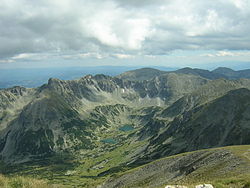
The source valley of the Maritsa river in the Rila Mountains with
941:
467:
1289:
Greece Defends Borders as Erdogan Opens the Gates: Live Updates
1011:
The river viewed from Turkey. Greek land visible on the right.
629:
623:
595:
583:
567:
540:
512:
483:
1277:
Turkish police bolster Greek border to stop migrants' return
695:
1103:. Publishing House of the Bulgarian Academy of Sciences.
502:
687:), marking the river as an external boundary of the EU.
1302:"Athens lodges demarche with Ankara over Evros dispute"
951:, which roughly follows the course of the river from
694:
from a variety of countries attempting to enter the
679:. This was further bolstered by Greece joining the
611:
297:
289:
277:
269:
230:
214:
204:
190:
177:
169:
160:
134:
129:
73:
43:
39:
881:Satellite image of floods along the river in 2006.
303:for mouth 234 m/s (8,300 cu ft/s)
430:. The Maritsa flows east-southeast between the
80:
594:) had become standard before the ancient form
558:
534:
539:. Thereafter, the river began to be known as
110:
49:
8:
652:, also known as the battle of Chernomen, an
1097:Georgiev, Vladimir Ivanov Georgiev (1981).
635:
605:
552:
95:
1150:: CS1 maint: location missing publisher (
718:The middle course of the Maritsa River at
426:in Western Bulgaria, its source being the
1078:National Statistical Institute (Bulgaria)
1342:(in Bulgarian). БАН, Труд, Сирма. 2002.
1317:
1315:
1124:Florov, Nicholas; Florov, Irina (2001).
963:, is also named in honour of the river.
482:The earliest known name of the river is
387:that runs solely in the interior of the
1338:"МАРИЦА (антично име: Хеброс, Хебър)".
1092:
1090:
1088:
1086:
1040:
1038:
1034:
970:
648:In 1371, the river was the site of the
281:53,000 km (20,000 sq mi)
1446:Rivers of Eastern Macedonia and Thrace
1202:How Old Are the River Names of Europe?
1143:
517:meant "wide". The Proto-Indo-European
36:
370:
353:
336:
223:, 14.5 km (9.0 mi) east of
7:
1046:"Preliminary Flood Risk Assessment"
1441:Landforms of Evros (regional unit)
891:largest flood taking place in 2021
25:
1421:Landforms of Pazardzhik Province
1016:
1004:
992:
973:
704:2020 Greek–Turkish border crisis
59:
1324:, Z. Nivolianitou, B. Synodinou
1240:10.1016/j.forsciint.2019.109875
922:is also a 1968 song written by
1401:International rivers of Europe
1228:Forensic Science International
1214:Evros: The immigrants' gateway
1171:. Neuried: Hieronymus Verlag.
955:(where it branches out of the
916:is named after Maritsa River.
393:largest in Europe by discharge
232: • coordinates
1:
1431:Landforms of Haskovo Province
1426:Landforms of Plovdiv Province
533:, creating the Thracian name
161:Physical characteristics
1416:Landforms of Edirne Province
999:View from the river, Edirne.
618:
590:
574:
547:
490:
415:, most of which lies in its
196:2,378 m (7,802 ft)
192: • elevation
1436:Landforms of Sofia Province
1127:Three-thousand-year-old Hat
959:) to the Turkish border at
944:is named after this river.
612:
216: • location
179: • location
44:
1467:
1340:Българска енциклопедия А-Я
668:, who died in the battle.
630:
624:
596:
584:
568:
541:
513:
299: • average
29:
1204:, Linguistik Online, 2015
1074:Statistical Yearbook 2017
747:(flows into Maritsa near
606:
422:It has its origin in the
350:
333:
307:
285:
273:480 km (300 mi)
200:
165:
96:
81:
58:
1216:. PBS.org, May 16, 2011.
1165:Duridanov, Ivan (1985).
32:Maritsa (disambiguation)
1168:Die Sprache der Thraker
1130:. Michigan University.
559:
535:
504:
498:, 7th–6th century BC).
484:
466:, which it enters near
1406:Bulgaria–Greece border
910:South Shetland Islands
882:
874:
734:
723:
683:in 1981 (and then the
636:
553:
379:that runs through the
367:
318:
111:
50:
880:
872:
729:
717:
316:
254:40.73056°N 26.03500°E
1411:Greece–Turkey border
1052:on 15 February 2020.
984:of Maritsa River at
848:/Ardas (near Edirne)
563:meaning 'splasher'.
450:in Turkey. East of
30:For other uses, see
27:River in the Balkans
930:and interpreted by
806:Right tributaries:
730:The Meriç River at
662:Vukašin Mrnjavčević
500:Proto-Indo-European
395:. It flows through
338:[mɐˈrit͡sɐ]
250: /
1391:Rivers of Bulgaria
1023:Boat on the delta.
883:
875:
741:Left tributaries:
735:
724:
600:was restituted in
319:
259:40.73056; 26.03500
1372:978-0-08-102612-0
1178:978-3-88893-031-7
906:Livingston Island
854:/Luda reka (near
836:Harmanliyska reka
656:victory over the
650:Battle of Maritsa
519:consonant cluster
436:Rhodope Mountains
391:, and one of the
372:[meɾit͡ʃ]
341:), also known as
311:
310:
16:(Redirected from
1458:
1396:Rivers of Turkey
1361:
1325:
1319:
1310:
1309:
1306:ekathimerini.com
1298:
1292:
1286:
1280:
1274:
1268:
1267:
1223:
1217:
1211:
1205:
1197:
1191:
1190:
1162:
1156:
1155:
1149:
1141:
1121:
1115:
1114:
1094:
1081:
1071:
1065:
1060:
1054:
1053:
1042:
1020:
1008:
996:
977:
961:Kapitan Andreevo
949:Maritsa motorway
830:Chepelarska reka
639:
633:
632:
627:
626:
621:
615:
609:
608:
599:
598:
593:
587:
586:
577:
571:
570:
562:
556:
550:
544:
543:
538:
516:
515:
507:
493:
487:
389:Balkan peninsula
374:
357:
355:[ˈevros]
352:
340:
335:
317:Map of the river
300:
265:
264:
262:
261:
260:
255:
251:
248:
247:
246:
243:
193:
180:
122:
114:
107:
99:
98:
92:
84:
83:
63:
53:
47:
37:
21:
1466:
1465:
1461:
1460:
1459:
1457:
1456:
1455:
1376:
1375:
1368:
1366:Further reading
1350:
1337:
1334:
1329:
1328:
1320:
1313:
1300:
1299:
1295:
1291:. 1 March 2020.
1287:
1283:
1279:. 6 March 2020.
1275:
1271:
1225:
1224:
1220:
1212:
1208:
1198:
1194:
1179:
1164:
1163:
1159:
1142:
1138:
1123:
1122:
1118:
1111:
1096:
1095:
1084:
1072:
1068:
1061:
1057:
1044:
1043:
1036:
1031:
1024:
1021:
1012:
1009:
1000:
997:
988:
978:
969:
957:Trakia motorway
899:
867:
712:
646:
634:, Latinized as
566:While the name
551:) in Greek and
480:
446:in Bulgaria to
428:Marichini Lakes
298:
258:
256:
252:
249:
244:
241:
239:
237:
236:
233:
217:
191:
178:
156:
125:
116:
101:
86:
69:
67:Marichini Lakes
54:
41:
35:
28:
23:
22:
15:
12:
11:
5:
1464:
1462:
1454:
1453:
1448:
1443:
1438:
1433:
1428:
1423:
1418:
1413:
1408:
1403:
1398:
1393:
1388:
1378:
1377:
1374:
1373:
1367:
1364:
1363:
1362:
1348:
1333:
1330:
1327:
1326:
1311:
1308:. 22 May 2020.
1293:
1281:
1269:
1218:
1206:
1192:
1177:
1157:
1136:
1116:
1109:
1082:
1066:
1055:
1033:
1032:
1030:
1027:
1026:
1025:
1022:
1015:
1013:
1010:
1003:
1001:
998:
991:
989:
979:
972:
968:
965:
947:The Bulgarian
928:Pierre Delanoë
898:
895:
866:
863:
862:
861:
860:
859:
852:Erythropotamos
849:
843:
833:
827:
817:
810:Chepinska reka
804:
803:
802:
792:
782:
772:
762:
752:
711:
708:
681:European Union
645:
642:
578:) was used in
479:
476:
424:Rila Mountains
417:drainage basin
309:
308:
305:
304:
301:
295:
294:
291:
287:
286:
283:
282:
279:
275:
274:
271:
267:
266:
234:
231:
228:
227:
225:Alexandroupoli
218:
215:
212:
211:
208:
202:
201:
198:
197:
194:
188:
187:
184:Rila Mountains
181:
175:
174:
171:
167:
166:
163:
162:
158:
157:
155:
154:
149:
144:
138:
136:
132:
131:
127:
126:
124:
123:
108:
93:
77:
75:
71:
70:
64:
56:
55:
42:
26:
24:
14:
13:
10:
9:
6:
4:
3:
2:
1463:
1452:
1451:Border rivers
1449:
1447:
1444:
1442:
1439:
1437:
1434:
1432:
1429:
1427:
1424:
1422:
1419:
1417:
1414:
1412:
1409:
1407:
1404:
1402:
1399:
1397:
1394:
1392:
1389:
1387:
1384:
1383:
1381:
1370:
1369:
1365:
1359:
1355:
1351:
1349:954-8104-08-3
1345:
1341:
1336:
1335:
1331:
1323:
1318:
1316:
1312:
1307:
1303:
1297:
1294:
1290:
1285:
1282:
1278:
1273:
1270:
1265:
1261:
1257:
1253:
1249:
1245:
1241:
1237:
1233:
1229:
1222:
1219:
1215:
1210:
1207:
1203:
1196:
1193:
1188:
1184:
1180:
1174:
1170:
1169:
1161:
1158:
1153:
1147:
1139:
1137:9780968848708
1133:
1129:
1128:
1120:
1117:
1112:
1110:9789535172611
1106:
1102:
1101:
1093:
1091:
1089:
1087:
1083:
1079:
1075:
1070:
1067:
1064:
1059:
1056:
1051:
1047:
1041:
1039:
1035:
1028:
1019:
1014:
1007:
1002:
995:
990:
987:
983:
976:
971:
966:
964:
962:
958:
954:
950:
945:
943:
939:
938:Hebrus Valles
935:
933:
932:Sylvie Vartan
929:
925:
921:
917:
915:
911:
907:
903:
896:
894:
892:
887:
879:
871:
864:
857:
853:
850:
847:
844:
841:
837:
834:
832:(near Sadovo)
831:
828:
825:
821:
818:
815:
811:
808:
807:
805:
800:
796:
793:
790:
786:
783:
780:
776:
773:
770:
766:
763:
760:
756:
753:
750:
746:
743:
742:
740:
739:
738:
733:
728:
721:
720:Nova Nadezhda
716:
709:
707:
705:
700:
697:
693:
688:
686:
685:Schengen area
682:
678:
674:
669:
667:
666:Jovan Uglješa
663:
659:
655:
651:
643:
641:
638:
620:
616:). The name
614:
603:
592:
581:
580:Ancient Greek
576:
564:
561:
555:
549:
537:
532:
528:
524:
520:
511:
510:Ancient Greek
506:
501:
497:
492:
486:
477:
475:
473:
469:
465:
461:
457:
453:
449:
445:
441:
437:
433:
429:
425:
420:
418:
414:
410:
409:drainage area
406:
402:
398:
394:
390:
386:
385:longest river
382:
378:
373:
369:
365:
361:
356:
348:
344:
339:
331:
327:
323:
315:
306:
302:
296:
292:
288:
284:
280:
276:
272:
268:
263:
235:
229:
226:
222:
219:
213:
209:
207:
203:
199:
195:
189:
185:
182:
176:
172:
168:
164:
159:
153:
150:
148:
145:
143:
140:
139:
137:
133:
128:
120:
113:
109:
105:
94:
90:
79:
78:
76:
72:
68:
62:
57:
52:
46:
38:
33:
19:
18:Evros (river)
1339:
1305:
1296:
1284:
1272:
1231:
1227:
1221:
1209:
1195:
1167:
1160:
1126:
1119:
1099:
1069:
1058:
1050:the original
946:
936:
919:
918:
902:Maritsa Peak
900:
888:
884:
856:Didymoteicho
824:Stamboliyski
779:Simeonovgrad
736:
701:
689:
670:
647:
602:Modern Greek
565:
530:
522:
481:
470:, forming a
444:Dimitrovgrad
421:
359:
342:
325:
321:
320:
924:Jean Renard
787:/Tunca (in
710:Tributaries
582:, the name
525:shifted in
472:river delta
257: /
74:Native name
1380:Categories
1332:References
1234:: 109875.
920:La Maritza
914:Antarctica
749:Pazardzhik
745:Topolnitsa
722:, Bulgaria
637:Merit(h)us
464:Aegean Sea
452:Svilengrad
278:Basin size
242:40°43′50″N
221:Aegean Sea
186:, Bulgaria
1358:163361648
1264:199438113
1248:1872-6283
1146:cite book
814:Septemvri
759:Ognyanovo
755:Luda Yana
330:Bulgarian
290:Discharge
135:Countries
89:Bulgarian
1256:31378400
1187:18925921
1063:inweb.gr
986:Harmanli
840:Harmanli
775:Sazliyka
692:migrants
527:Thracian
397:Bulgaria
375:), is a
245:26°2′6″E
142:Bulgaria
130:Location
1386:Maritsa
1080:, p. 17
982:freshet
980:Spring
967:Gallery
953:Chirpan
908:in the
785:Tundzha
765:Stryama
660:rulers
658:Serbian
654:Ottoman
644:History
631:Μήριζος
625:Μηρισός
619:Maritsa
591:Maritsa
585:Μαρίτσα
505:h₁wérus
456:Tundzha
440:Plovdiv
438:, past
381:Balkans
364:Turkish
326:Maritza
322:Maritsa
119:Turkish
40:Maritsa
1356:
1346:
1262:
1254:
1246:
1185:
1175:
1134:
1107:
897:Trivia
865:Floods
838:(near
822:(near
812:(near
799:İpsala
797:(near
795:Ergene
789:Edirne
777:(near
769:Sadovo
767:(near
757:(near
732:Edirne
677:Turkey
673:Greece
610:(now:
575:Hébros
554:Hebrus
548:Hébros
496:Alcman
448:Edirne
432:Balkan
413:Thrace
407:. Its
405:Turkey
401:Greece
358:) and
334:Марица
293:
270:Length
210:
173:
170:Source
152:Turkey
147:Greece
115:
100:
85:
82:Марица
1260:S2CID
1029:Notes
820:Vacha
613:Évros
607:Έβρος
597:Ἕβρος
569:Ἕβρος
560:ebros
542:Ἕβρος
536:Ebros
514:εὐρύς
503:*
491:Euros
485:Εύρος
478:Names
377:river
368:Meriç
360:Meriç
351:Έβρος
347:Greek
343:Evros
206:Mouth
112:Meriç
104:Greek
97:Έβρος
51:Meriç
45:Évros
1354:OCLC
1344:ISBN
1252:PMID
1244:ISSN
1183:OCLC
1173:ISBN
1152:link
1132:ISBN
1105:ISBN
942:Mars
926:and
846:Arda
675:and
664:and
531:-br-
523:-wr-
508:and
468:Enez
460:Arda
458:and
442:and
434:and
403:and
1236:doi
1232:302
940:on
904:on
628:or
604:as
529:to
324:or
1382::
1352:.
1314:^
1304:.
1258:.
1250:.
1242:.
1230:.
1181:.
1148:}}
1144:{{
1085:^
1076:,
1037:^
934:.
912:,
696:EU
640:.
494:,
419:.
366::
349::
332::
48:,
1360:.
1266:.
1238::
1189:.
1154:)
1140:.
1113:.
858:)
842:)
826:)
816:)
801:)
791:)
781:)
771:)
761:)
751:)
588:(
572:(
545:(
521:*
488:(
362:(
345:(
328:(
121:)
117:(
106:)
102:(
91:)
87:(
34:.
20:)
Text is available under the Creative Commons Attribution-ShareAlike License. Additional terms may apply.