40:
24:
32:
292:
A photograph of the construction workers shows the deep cutting into the hard rock forming the Egge; the photograph was taken soon after the cutting was made all the way through on 1 June 1926. Heimat- und
Verkehrsverein Börninghausen-Eininghausen :
258:
170:
The steep northern slopes of the Eggen are predominantly forested; the woods cover an area of around 1,300 hectares. Whilst in the north the forest boundary extends as low as
174:
in places, the southern slopes with their more suitable gentler slopes enable their cultivation up to an average of around 150 metres and, in places, 200 metres. The
234:, cut 9 metres deep into the rock. The road and cutting were carried out as emergency work from 1924 to 1927. This road link, which replaced the historical
269:
317:
122:
The ridge runs parallel to the main crest of the Wiehen at a distance of around two to three kilometres from it and between the villages of
149:
of the same name that is situated in the far east of the ridge and is a popular tourist destination. Before it to the west is the
376:
371:
361:
74:
in North
Germany. The state border between North Rhine-Westphalia and Lower Saxony divides the ridge at a pass called the
306:
381:
189:
The summits of the Egge have, like almost all the hills in the Wiehen, an elongated crest, which are also called
183:
17:
71:
39:
101:
23:
142:
79:
67:
123:
366:
31:
242:
and runs through
Oldendorf Switzerland, explains the steep climb just before the heights of the Egge.
160:
164:
175:
138:
356:
215:. The clearly defined crests may have derived their names for the formerly common description of
83:
179:
155:
63:
44:
226:
The pass above the town of Preußisch
Oldendorf for the aforementioned north-south link, the
134:
107:; this usage is rare however. The section of the main crest of the Wiehen Hills between
146:
350:
206:
137:
in the west of the Egge. At the same time there is a parcel of arable land north of
59:
141:
that, at 218 metres, is somewhat higher. The best-known hill on the Egge is the
43:
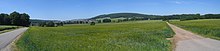
View of the Egge from Glösinghausen. Foreground right: the
Limberg. Left: the
96:
332:
319:
127:
211:
220:
38:
30:
22:
16:
For the range forming the extension of the
Teutoberg Forest, see
153:
a large, cleared upland over which runs a road link from the
89:
In addition to describing the entire ridge, in many maps the
130:
and Bad
Holzhausen in the borough of Preußisch Oldendorf.
58:
is a roughly seven-kilometre-long secondary ridge of the
93:
is also shown as referring to a summit with a height of
86:, about two-thirds of the Egge belonging to Westphalia.
133:
The highest hill on the ridge is the 211-metre-high
297:Preußisch Oldendorf: Kölle-Druck, 1993, p. 110.
182:. The eastern part of the Egge belongs to the
8:
27:Contour map of the Egge (northernmost ridge)
78:("breakthrough") over which the road from
35:Limberg and Offelter Berg from the south
250:
205:are separated from one another only by
178:near the state border is a well known
100:north of Eininghausen and east of the
7:
295:1000 Jahre Börninghausen 993 - 1993.
14:
261:Arbeit über das LSG Wiehengebirge
223:", the edge of a strip of linen.
201:) north of Eininghausen. These
1:
199:198 m above NN
105:201 m above NN
82:runs into the Eggetal and to
172:70 m above NN
95:198 m above
66:valley in the districts of
398:
62:and gives its name to the
56:Preußisch Oldendorfer Berg
15:
184:Limberg und Offelter Berg
193:like the peak of Gipfel
18:Egge (Lower Saxon Hills)
115:is referred in maps as
372:Hill ranges of Germany
333:52.288743°N 8.489685°E
47:
36:
28:
230:79, is an artificial
42:
34:
26:
377:Osnabrück (district)
362:Preußisch Oldendorf
338:52.288743; 8.489685
329: /
80:Preußisch Oldendorf
236:Eininghauser Patt,
126:in the borough of
54:, also called the
48:
37:
29:
180:observation tower
389:
344:
343:
341:
340:
339:
334:
330:
327:
326:
325:
322:
310:
304:
298:
290:
284:
283:
281:
280:
274:
268:. Archived from
267:
255:
240:Eininghauser Weg
200:
186:Nature Reserve.
173:
163:federal road to
106:
99:
397:
396:
392:
391:
390:
388:
387:
386:
382:Minden-Lübbecke
347:
346:
337:
335:
331:
328:
323:
320:
318:
316:
315:
313:
305:
301:
291:
287:
278:
276:
272:
265:
257:
256:
252:
248:
198:
171:
135:Schwarzer Brink
104:
94:
72:Minden-Lübbecke
21:
12:
11:
5:
395:
393:
385:
384:
379:
374:
369:
364:
359:
349:
348:
312:
311:
299:
285:
249:
247:
244:
119:("The Egge").
97:sea level (NN)
13:
10:
9:
6:
4:
3:
2:
394:
383:
380:
378:
375:
373:
370:
368:
365:
363:
360:
358:
355:
354:
352:
345:
342:
308:
303:
300:
296:
289:
286:
275:on 2012-03-30
271:
264:
262:
254:
251:
245:
243:
241:
237:
233:
229:
224:
222:
218:
214:
213:
208:
204:
196:
192:
187:
185:
181:
177:
168:
166:
165:Börninghausen
162:
158:
157:
152:
148:
144:
140:
136:
131:
129:
125:
120:
118:
114:
110:
103:
98:
92:
87:
85:
81:
77:
73:
69:
65:
61:
57:
53:
46:
41:
33:
25:
19:
367:Wiehen Hills
314:
302:
294:
288:
277:. Retrieved
270:the original
260:
253:
239:
235:
231:
227:
225:
216:
210:
202:
194:
190:
188:
176:Wiehen Tower
169:
154:
150:
147:castle ruins
139:Büscherheide
132:
121:
116:
112:
108:
90:
88:
75:
60:Wiehen Hills
55:
51:
49:
336: /
307:Gedenktafel
228:Kreisstraße
219:m meaning "
207:hill passes
151:Balkenkamp,
84:Bruchmühlen
351:Categories
321:52°17′19″N
279:2011-08-13
246:References
238:is called
113:Horst Höhe
109:Neue Mühle
76:Durchbruch
357:Bad Essen
324:8°29′23″E
263:, page 3"
145:with its
128:Bad Essen
68:Osnabrück
156:landwehr
117:Die Egge
102:Geisberg
221:selvage
209:called
159:to the
143:Limberg
124:Lintorf
64:Eggetal
45:Eggetal
273:(PDF)
266:(PDF)
212:Dören
203:Eggen
191:Eggen
232:Döre
217:Egge
195:Egge
161:B 65
111:and
91:Egge
70:and
52:Egge
50:The
353::
167:.
309:.
282:.
259:"
197:(
20:.
Text is available under the Creative Commons Attribution-ShareAlike License. Additional terms may apply.