1279:
leaves no doubt that
Palestine did not include Transjordan in prior periods ... The Zionist and later on the Israeli discourse stresses the 'fact' that Israel emerged on only a very small part of Palestine – less than a third – by which they mean the entirety of Palestine and Transjordan; hence the term 'the partitioned State' ... While Israel officially is more circumspect in its pronouncements, its official spokesmen often refer to Jordan as a Palestinian State and claim that Palestinians already therefore have a state of their own. A series of advertisements that appeared in major American newspapers in the course of 1983 claimed openly that Jordan is Palestine. The series was presumably paid for by 'private' sponsors who support Israel but have been reported to be acting on behalf of certain sectors of Israel's leadership. Though rightly discredited as spurious scholarship, Joan Peters's From Time Immemorial (1984) gave much publicity to the Zionist definition of Palestine as including Transjordan (and, throughout, her work utilizes seriously flawed data that specifically refer to 'Western Palestine'). Perhaps Israel's preference for a solution to the Palestinian-Israeli conflict in terms of what has become known as the 'Jordanian' option reflects the same understanding."
251:
425:
821:
238:
789:
In 1964, concluding its work, the committee suggested to the two governments that the area be deemed the property of
Lebanon, and recommended that the international border be reestablished consistent with its suggestion. However, neither Syria nor Lebanon adopted the committee's suggestion, and neither country took any action along the suggested lines. Thus, maps of the area continued to reflect the Farms as being in Syria. Even maps of both the Syrian and Lebanese armies continued to demarcate the region within Syrian territory (see map).
1269:
Zionist approval as treason. The call 'Two banks for the Jordan river – this one is ours and so is the other' was heard from then onward. Even the other side of the Jewish political map did not lose its faith in achieving a better political solution, and in a famous song – which was composed many years later – one can find the words 'from
Metulla to the Negev, from the sea to the desert'. The allusion is clearly to the desert that lies east of the Trans-Jordanian heights and not to the Judean desert."
1249:
language confuses some readers into imagining that
Transjordanian territory was covered by the conditions of the Mandate as to the Jewish National Home before August 1921. Not so; what became Transjordanian territory was not part of the mandate at all. As noted, it was part of the Arabian Chapter problem; it was, in other words, in a state of postwar legal and administrative limbo. And this is also not to speak of the fact that, as of August 1921, the mandates had yet to be approved or take effect."
40:
952:, to be known as the State of Israel." Epstein, Agent, Provisional Government of Israel said in a letter to President Truman seeking recognition from the U.S. government, sent immediately after the Declaration of May 14, 1948, "that the state of Israel has been proclaimed as an independent republic within frontiers approved by the General Assembly of the United Nations in its Resolution of November 29, 1947", (i.e., within the area designated as the "Jewish state" in the partition plan).
829:
893:. Taba was on the Egyptian side of the armistice line of 1949, but Israel claimed that Taba had been on the Ottoman side of a border agreed between the Ottomans and British Egypt in 1906, and that there had previously been an error in marking the line. The issue was submitted to an international commission composed of one Israeli, one Egyptian, and three outsiders. In 1988, the commission ruled in Egypt's favor, and Israel withdrew from Taba later that year.
907:
482:
3033:
1120:
3043:
257:
administration different from that of
Palestine, however undesirable it may be for His Majesty's Government themselves to propose alterations of the mandates at this stage, they were inclined to view that when the "A" mandates come to be considered by the Council of the League it would be wise in this case to propose to that body the insertion... after article 24 of the Palestine mandate..."
1239:
assistant legal adviser to the
Foreign Office. Their suggestion, on the 25th by Shuckburgh, was that... a clause be inserted in each of the mandates... The first draft of Article 25 was originally worded "to postpone the application of such provisions," but was altered at Shuckburgh's initiative since "'postpone' means, or may be taken to mean, that we are going to apply them eventually""
171:
636:. At the same time, the United Nations did not have to consider the legality of the boundary between Lebanon and the Israeli-controlled Golan Heights, as that was not required for the purpose of Council Resolution 425. Accordingly, the Armistice Demarcation Line between Lebanon and the Israeli-controlled Golan Heights is expressly not to be called the Blue Line.
757:
594:
382:, signed on October 26, 1994, resolved all outstanding territorial and border issues between the two countries that had existed since the 1948 War. The treaty specified and fully recognized the international border between Israel and Jordan, with Jordan confirming its renunciation of any claim to the West Bank. Upon its signing, the
937:, on behalf of the Jewish community, despite its misgivings, indicated acceptance of the plan. With a few exceptions, the Arab leaders and governments rejected the plan of partition in the resolution and indicated that they would reject any other plan of partition. Britain declared that the Mandate was to end on May 15, 1948.
470:
final report on
February 3, 1922, and it was approved with some caveats by the British and French governments on March 7, 1923, several months before Britain and France assumed their Mandatory responsibilities on September 29, 1923. In accordance with the same process, a nearby parcel of land that included the ancient site of
1258:
Wasserstein writes: "Palestine, therefore, was not partitioned in 1921–1922. Transjordan was not excised but, on the contrary, added to the mandatory area. Zionism was barred from seeking to expand there – but the
Balfour Declaration had never previously applied to the area east of the Jordan. Why is
1248:
Adam
Garfinkle explained, "After the Cairo Conference of March 1921, whereupon the Emirate of Transjordan was created, Article 25 pertaining to Transjordan was added to the draft Mandate – in August 1921. Article 25 notes that Transjordanian territory is not included in the Jewish National Home. This
1010:
of Israel passed a law to annex all land that Israel had captured in the war, and declaring that from then on, any part of
Palestine taken by the Israeli army would automatically be annexed to Israel. This, effectively, annexed to Israel all land within the Green Line, though the armistice agreements
872:
had not been built, and the Ottomans therefore had no simple access to the Red Sea. The British were also interested in making the border as short and patrollable as possible, and some contest that it did not take into account the needs of the local residents in the negotiations, although its clauses
764:
The Shebaa Farms conflict stems from Israel's occupation and annexation of the Golan Heights, with respect to that territory's border with Lebanon. Both Lebanon and Syria were within the French Mandate territory between 1920 and the end of the French Mandate in 1946. The dispute over the sovereignty
788:
Border disputes arose at times, however. Shebaa Farms was not unique; several other border villages had similar discrepancies of borders versus land ownership. Syria and Lebanon formed a joint Syrian–Lebanese border committee in the late 1950s to determine a proper border between the two nations.
1268:
Biger wrote, "The results of the Cairo conference were a failure for the Zionist Organization, but Britain had won itself a devoted ally east of the Jordan ... Certain Zionist politicians, and especially the circles that surrounded Ze'ev Jabutinski, regarded the British decisions and the quiet
1238:
Klieman writes: "Accordingly, Churchill cabled the Colonial Office on 21 March, asking whether the Cairo proposals would necessitate any special provisions being made in the two mandates... Upon receipt of this cable informal consultation took place between the Colonial Office legal adviser and the
316:
writes that the public clarification and implementation of Article 25, more than a year after its addition to the Mandate, misled some "into imagining that Transjordanian territory was covered by the conditions of the Mandate as to the Jewish National Home before August 1921". This would, according
296:
approved the Palestine Mandate, which came into effect in 1923 after a dispute between France and Italy over the Syria Mandate was settled. The Mandate stated that Britain could 'postpone or withhold' application of the provisions dealing with the 'Jewish National Home' in the territory east of the
243:
March 12, 1921, British memorandum explaining the situation of Transjordan: "His Majesty's Government have been entrusted with the Mandate for "Palestine." If they wish to assert their claim to Trans-Jordan and to avoid raising with other Powers the legal status of that area, they can only do so by
659:
heard views in Israel, Lebanon and Syria. The United Nations cartographer and his team, assisted by UNIFIL, worked on the ground to identify a line to be adopted for the practical purposes of confirming the Israeli withdrawal. While it was agreed that this would not be a formal border demarcation,
776:
Documents from the 1920s and 1930s indicate that some local inhabitants regarded themselves as part of Lebanon, for example paying taxes to the Lebanese government. But French officials at times expressed confusion as to the actual location of the border. One French official in 1939 expressed the
1278:
Abu-Lughod, writing in 1988: "... the statement presented by Mr Herbert Samuel, the first British High Commissioner, to the League of Nations on the administration of Palestine and Transjordan between 1920–25 ... is sufficiently clear on the distinctness of Transjordan and its emergence and
469:
A 1920 agreement defined the boundary between the forthcoming British and French mandates in broad terms, and placed the bulk of the Golan Heights in the French sphere. The agreement also established a joint commission to settle the border and mark it on the ground. The commission submitted its
256:
March 25, 1921, proposal, approved a week later, to include Transjordan via Article 25: "On the assumption that... provision is made in some way in final political arrangements as regards Trans-Jordania for its inclusion within the boundaries of Palestine as eventually fixed, but under a form of
63:
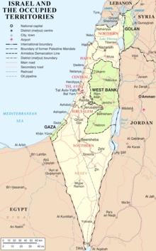
and its neighbours, as well as an effect of the agreements among colonial powers ruling in the region before Israel's creation. Only two of Israel's five total potential land borders are internationally recognized and uncontested, while the other three remain disputed; the majority of its border
1104:
At the same time, Israel has continued to claim a nominal strip on the border between the West Bank and Jordan, and between Gaza and Egypt as its border with those countries. This is viewed as a legalistic device to enable Israel to control the entry of people and materials into the Palestinian
576:
During the 1990s, there were constant negotiations between Israel and Syria regarding a mediation of conflicts and an Israeli withdrawal from the Golan Heights but a peace treaty did not come to fruition. The main stumbling block seems to involve the 66 square kilometers of territory that Syria
364:, rather than a permanent border, and the Armistice Agreements relegated the issue of permanent borders to future negotiations. After the armistice, Transjordan was in control of what came to be called the West Bank. East Jerusalem, including the Old City, was considered part of the West Bank.
1385:
of the boundary between French Syria and Palestine, which will constitute the northern frontier and the eastern line of demarcation, adjoining Arab Syria. The latter is not likely to be fixed until the Emir Feisal attends the Peace Conference, probably in Paris." See: 'Zionist Aspirations: Dr
664:
that it had redeployed its forces in compliance with Council Resolution 425, that is to the Internationally recognized Lebanese border. On June 7, the completed map showing the withdrawal line was formally transmitted by the force commander of UNIFIL to his Lebanese and Israeli counterparts.
796:
In 1967, most Shebaa Farms landowners and (Lebanese) farmers lived outside the Syrian-controlled region, across the Lebanon-Syrian border, in the Lebanese village of Shebaa. During the Six Day War in 1967, Israel captured the Golan Heights from Syria, including the Shebaa Farms area. As a
651:
On April 17, 2000, Israel announced that it would withdraw its forces from Lebanon. The Lebanese government refused to take part in marking the border. The UN thus conducted its own survey based on the line for the purpose of Council Resolution 425, which called for "strict respect for the
732:
In 1923, 38 boundary markers were placed along the 78-kilometre (48-mile) boundary and a detailed text description was published. The 2000 Blue Line differs in about a half dozen short stretches from the 1949 line, although never by more than 475 metres (1,558 ft).
402:
were officially designated as the borders between Israel and Jordan and between Jordan and the territory occupied by Israel in 1967. For the latter, the agreement requires that the demarcation use a different presentation, and that it carry the following disclaimer:
792:
A number of local residents regarded themselves as Lebanese, however. The Lebanese government showed little interest in their views. The Syrian government administered the region, and on the eve of the 1967 war, the region was under effective Syrian control.
375:, though Jordan continued to claim the territory as its own after that date. In July 1988, Jordan renounced all claims to the West Bank, in favour of the Palestinian Liberation Organisation, as the "sole legitimate representative of the Palestinian people".
956:
643:
before March 14, 1978, when Israel invaded Lebanon. In effect that line was recognised by both Lebanon and by Israel as the international border, and not just as the Armistice Demarcation Line of 1949 (what is commonly called the Green Line) following the
244:
proceeding upon the assumption that Trans-Jordan forms part of the area covered by the Palestine Mandate. In default of this assumption Trans-Jordan would be left, under article 132 of the Treaty of Sèvres, to the disposal of the principal Allied Powers."
811:
As of April 2021, there was an ongoing dispute over the Mediterranean Sea border between Israel and Lebanon. Negotiations on the maritime border commenced in October 2020 and led to success, i.e. both sides reaching and ratifying an agreement in 2022.
1204:
clarified "that the final status , including the borders, would be left to the two parties to negotiate and decide." Since then, several other countries have formally recognised Jerusalem as the capital of Israel, and moved their embassies there.
747:
that Israel had withdrawn its forces from Lebanon in accordance with Council Resolution 425 and met the requirements defined in his report of May 22, 2000. The withdrawal line has been termed the Blue Line in all official UN communications since.
780:
The region continued to be represented in the 1930s and 1940s as Syrian territory, under the French Mandate. Detailed maps showing the border were produced by the French in 1933, and again in 1945. They clearly showed the region to be in Syria.
371:, with the border being the 1949 armistice line, though Jordan laid claim to all of Mandate Palestine. Jordan's annexation was only recognised by three countries. The West Bank remained part of Jordan until Israel captured it in 1967, during the
1034:
In 2011, Palestine submitted an application for membership to the United Nations, using the borders for military administration that existed before 1967, effectively the 1949 armistice line or Green Line. As Israel does not recognize the
889:, signed on March 26, 1979, created an officially recognized international border along the 1906 line, with Egypt renouncing all claims to the Gaza Strip. A dispute arose over the marking of the border line at its southernmost point, in
881:
The 1949 armistice agreement between Israel and Egypt was ratified on February 24, 1949. The armistice line between these countries followed the international border except along the Gaza Strip, which remained under Egyptian occupation.
660:
the aim was to identify a line on the ground closely conforming to the internationally recognized boundaries of Lebanon, based on the best available cartographic and other documentary evidence. On May 25, 2000, Israel notified the
665:
Notwithstanding their reservations about the line, the governments of Israel and Lebanon confirmed that identifying this line was solely the responsibility of the United Nations and that they would respect the line as identified.
1092:
which calls for the return by Israel to "the 1967 borders". While Israel has expressed desire to annex the border settlement blocs and keep East Jerusalem, its border with Gaza has largely been solidified, especially following
851:
According to the personal documents of the British colonel Wilfed A. Jennings Bramley, who influenced the negotiations, the border mainly served British military interests—it furthered the Ottomans as much as possible from the
784:
After the French Mandate ended in 1946, the land was administered by Syria, and represented as such in all maps of the time. The maps of the 1949 armistice agreement between Syria and Israel also designated the area as Syrian.
877:
rights according to tribal rules for the Naqb (Negev) and Sinai Bedouin. It was defined as an "administrative separating line" for diplomatic reasons, allowing the Ottoman Empire to hold to its nominal sovereignty over Egypt.
541:(DMZs) and remained under Syrian control (marked as DMZs on the map). It was emphasised that the armistice line was "not to be interpreted as having any relation whatsoever to ultimate territorial arrangements." (Article V)
2153:"Letter From the Agent of the Provisional Government of Israel to the President of the United States: May 15, 1948: Harry S. Truman Library & Museum: The Recognition of the State of Israel: Retrieved 30 December 2014"
250:
560:
throughout the Golan Heights, and offered the Druze and Circassian residents citizenship, which most turned down. Today, Israel regards the Golan Heights as its sovereign territory, and a strategic necessity. The
1181:
The purported annexation of East Jerusalem was criticised by Palestinian, Arab and other leaders, and was declared by the United Nations Security Council "a violation of international law" and "null and void" in
1170:, declaring Jerusalem to be the "complete and united" capital of Israel. The Israeli government offered citizenship to the Palestinian residents of that territory, most of whom refused, and are treated today as
407:
This line is the administrative boundary between Jordan and the territory which came under Israeli military government control in 1967. Any treatment of this line shall be without prejudice to the status of the
987:, rather than a permanent border, and the Armistice Agreements relegated the issue of permanent borders to future negotiations. The area to the west of the Jordan River came to be called the West Bank, and was
1381:, subsequently reported to his colleagues in London: "There are still important details outstanding, such as the actual terms of the mandate and the question of the boundaries in Palestine. There is the
213:(April 19–26, 1920) the Allied Supreme Council determined that mandates for Palestine and Mesopotamia would be allocated to Britain without precisely defining the boundaries of the mandated territories.
1197:
2459:
Agreement between His Majesty's Government and the French Government respecting the Boundary Line between Syria and Palestine from the Mediterranean to El Hámmé, Treaty Series No. 13 (1923), Cmd. 1910.
1669:
Agreement between His Majesty's Government and the French Government respecting the Boundary Line between Syria and Palestine from the Mediterranean to El Hámmé, Treaty Series No. 13 (1923), Cmd. 1910.
2323:
537:
with Israel retained 66 square kilometers of that territory in the Jordan Valley that lay west of the 1923 Palestinian Mandate border (marked green on Map 4). These territories were designated
202:
321:, result in "the myth of Palestine's 'first partition' part of the concept of 'Greater Israel' and of the ideology of Jabotinsky's Revisionist movement". Palestinian-American academic
2152:
617:
and Resolution 426 calling for the withdrawal of Israeli forces from Lebanon. Israeli forces withdrew later in 1978, but turned over their positions inside Lebanon to their ally, the
975:. Following internationally supervised Arab-Israeli negotiations, a boundary based on the cease-fire lines of the war with minor territorial adjustments, commonly referred to as the
2210:
971:. The tide of battle soon turned against the Arabs, and Israel then launched a series of military offensives, greatly expanding its territorial holdings. The end of the war saw the
1259:
this important? Because the myth of Palestine's 'first partition' has become part of the concept of 'Greater Israel' and of the ideology of Jabotinsky's Revisionist movement."
1024:
109:
3770:
721:
Unlike the other Green Line agreements, it contains no clause disclaiming this line as an international border, and was thereafter treated as it had been previously, as the
1360:
Pappe, p. 3–4. Pappe suggests the French concessions were made to guarantee British support for French aims at the post-war peace conference concerning Germany and Europe.
736:
Between 1950 and 1967, Israeli and Lebanese surveyors managed to complete 25 non-contiguous kilometers and mark (but not sign) another quarter of the international border.
2523:
Franco-British Convention on Certain Points Connected with the Mandates for Syria and the Lebanon, Palestine and Mesopotamia, signed December 23, 1920. Text available in
1031:
to the Palestinian Liberation Organisation, which had been previously designated by the Arab League as the "sole legitimate representative of the Palestinian people".
2184:
964:
1183:
566:
1564:
2249:
Korman, Sharon (2005). The right to conquest: the acquisition of territory by force in international law and practice. Oxford University Press US. pp. 250–260.
999:
of 1967, Israel captured the West Bank from Jordan, Gaza Strip and Sinai peninsula from Egypt, and Golan Heights from Syria, and placed these territories under
1857:
806:
329:
political science department, suggested that the "Jordan as a Palestinian State" references made by Israeli spokespeople may reflect "the same understanding".
3247:
1976:
517:, including a 10-metre-wide strip along the northeastern shore, were part of Palestine. The agreement added 227 square kilometers to the area of Palestine.
3118:
930:
179:
151:
2567:
Gil-Har, Yitzhak (1993), British commitments to the Arabs and their application to the Palestine-Trans-Jordan boundary: The issue of the Semakh triangle,
3383:
2140:
344:
entered from the east what had been the Palestinian part of the Palestinian Mandate, while other Arab armies invaded other parts of the territory. The
1323:
Unique to states in the contemporary world, only two of Israel's five potential land borders have the status of internationally recognized boundaries.
1162:
to cover the whole of East Jerusalem and the surrounding area, and applied its laws, jurisdiction, and administration to that territory. In 1980, the
1094:
548:(1967), Israel captured the territory as well as the rest of the Golan Heights, and subsequently repelled a Syrian attempt to recapture it during the
201:. They agreed that "Palestine" was to be designated as an "international enclave". This agreement was revised by Britain and France in December 1918;
2006:
3765:
3079:
2947:
1020:
2123:
1884:"SECURITY COUNCIL ENDORSES SECRETARY-GENERAL"S CONCLUSION ON ISR"LI WITHDRAWAL FROM LEBANON AS OF 16 JUNE - Meetings Coverage and Press Releases"
933:
into "Independent Arab and Jewish States" and a "Special International Regime for the City of Jerusalem" administered by the United Nations. The
309:
to the League of Nations defining the border of Transjordan and confirming its exclusion from all the provisions dealing with Jewish settlement.
2409:
836:. The reason for the color difference is likely a higher level of grazing by the Bedouin-tended animal herds on the Egyptian side of the border.
30:
This article is about the borders of the modern State of Israel. For the ancient Halakhic delineation of the borders of the Land of Israel, see
3689:
3410:
2625:
2621:
2617:
2613:
1833:
1688:
922:
3169:
3499:
2643:
2475:
2384:
2254:
2159:
1737:
1447:
1316:
992:
988:
368:
2284:
1054:
1046:
of 1979, Egypt renounced all claims to the Gaza Strip. In 1988, Jordan renounced all claims to the West Bank; this was made official in the
3760:
2674:
1178:, if these Palestinians live abroad for seven years, or gain citizenship or residency elsewhere, they lose their Israeli residency status.
832:
A clearly visible line marks about 80 kilometers (~50 mi) of the international border between Egypt and Israel in this photograph from the
710:
The armistice line (i.e., "Green Line") was the international border, which corresponds to the 1923 Mandate border between the Lebanon and
2214:
424:
2458:
1671:
3317:
3152:
3108:
1300:
873:
did allow free access to the water sources west of the line to civilians, military and gendarmes from the Ottoman side, as well as full
68:, which saw Israel occupy large swathes of territory from its rivals. Israel's two formally recognized and confirmed borders exist with
3669:
1795:
1214:
629:
614:
1047:
1042:
Israel and the Palestinian territories now lay entirely within the boundaries of the former territory of Mandatory Palestine. By the
2589:
2517:
2493:
2094:
1781:
820:
3164:
2998:
1080:
be removed from Israeli sovereignty and transferred to the Palestinian Authority, in exchange for the border settlement blocs. The
3715:
3474:
3092:
1097:
in 2005. Israel has not made claims to any portion of Gazan territory and offered the entire area to Palestinians as part of the
337:
Transjordan gained independence from Britain in 1946 within the above borders, prior to the termination of Mandatory Palestine .
963:
On May 15, regular Arab armies entered what had been Mandate Palestine. This intervention/invasion marked the transition of the
696:
between Lebanon and Israel. The area east of the Hasbani River is considered part of Syria and included in the Golan Heights.
3176:
379:
237:
81:
3775:
3378:
1596:
1190:
455:
3008:
1043:
886:
652:
territorial integrity, sovereignty and political independence of Lebanon within its internationally recognized boundaries".
498:
443:
435:
158:, and confirmed in the 1979 Egypt–Israel peace treaty; the Israeli border with Jordan is based on the border defined in the
77:
2188:
773:
administrations, and subsequently from the failure of the Lebanon and Syria to properly demarcate the border between them.
478:. When the French Mandate of Syria ended in 1944, the Golan Heights remained part of the newly independent state of Syria.
3422:
2922:
565:
marks the boundary between Israel and Syria. Israel's unilateral annexation has not been internationally recognized, and
3601:
3346:
570:
562:
48:
2967:
1712:
134:
by Lebanon to the north, the Golan Heights under Syrian sovereignty as well as the rest of Syria to the northeast, the
3459:
3307:
3181:
3072:
2061:
1186:, and has not been recognized by the international community, and all countries moved their embassies from Jerusalem.
972:
934:
833:
434:, October 25, 1920, reporting on the active discussions regarding the boundary line; this was later formalised in the
349:
209:
would be part of the British sphere in exchange for British support of French influence in Syria and Lebanon. At the
1861:
3755:
3513:
3464:
2867:
581:
countries support Syria's position in the formula which calls on Israel "to return to the 1967 borders". (See 2002
3159:
2757:
1984:
1131:
968:
645:
530:
345:
194:
183:
3674:
3584:
3427:
3003:
1219:
1058:
1007:
980:
770:
693:
597:
Map 5: The Blue Line covers the Lebanese–Israeli border; an extension covers the Lebanese–Golan Heights boundary.
534:
463:
447:
353:
127:
2962:
263:
Between March 12–25, 1921, the inclusion of Transjordan in the mandate was formulated by the British Government.
3295:
3252:
3215:
2689:
2667:
2536:
2484:
Biger, Gideon (1989), Geographical and other arguments in delimitation in the boundaries of British Palestine,
1768:
506:
2972:
2917:
2882:
2837:
3659:
3484:
3373:
3360:
3225:
3186:
2807:
2802:
2697:
1065:, including all three major cities, and only a minor Palestinian population, was declared by Prime Minister
475:
459:
326:
159:
105:
2927:
2902:
2817:
2797:
2747:
2717:
1053:
The boundaries of a future Palestinian State, vis-a-vis Israel, are subject to ongoing negotiations in the
906:
150:
to the southwest. The Israeli border with Egypt is the international border demarcated in 1906 between the
3634:
3557:
3530:
3405:
3065:
2892:
2887:
1632:
1098:
848:
was drawn in the Ottoman–British agreement of October 1, 1906, after a military crisis earlier that year.
526:
306:
302:
2957:
2907:
2842:
2732:
3684:
3629:
3562:
3449:
3400:
2847:
2827:
2712:
2707:
2702:
2310:
2024:
1961:
1382:
1089:
1081:
640:
582:
502:
474:
was transferred from Syria to Palestine early in 1924. In this way the Golan Heights became part of the
451:
286:
227:
175:
39:
2977:
2812:
2742:
2727:
699:
The armistice agreement between Lebanon and Israel was signed on March 23, 1949. The main points were:
2937:
2897:
2872:
2852:
2787:
2752:
2127:
728:
Israel withdrew its forces from 13 villages in Lebanese territory, which were occupied during the war.
668:
On June 8, 2000, UNIFIL teams commenced the work of verifying the Israeli withdrawal behind the line.
656:
446:, a series of agreements between 1920 and 1923, contained the principles for the boundary between the
3654:
3552:
3368:
3329:
3113:
3013:
2857:
2822:
2777:
2767:
2368:
1613:"The Avalon Project: Treaty of Peace Between the State of Israel and the Hashemite Kingdom of Jordan"
1147:
740:
661:
282:
2605:
Muhsin, Yusuf (1991), The Zionists and the process of defining the borders of Palestine, 1915–1923,
1840:
1695:
3574:
3547:
3494:
3341:
3334:
3302:
3220:
3198:
3147:
2987:
2862:
2832:
2660:
2424:. Vol. 2. Institute for Zionist Research Founded in Memory of Chaim Weizmann. pp. 87–98.
1952:
1932:
1883:
1618:
1171:
1114:
1000:
976:
828:
715:
689:
357:
318:
198:
123:
3042:
959:
Map 8: Israel's 1949 Green Line (green thin line) and demilitarized zones (green thick line/areas)
3649:
3611:
3596:
3479:
3278:
3264:
2932:
2437:
2415:
2394:
2360:
2288:
1980:
1819:
Jeremy Pressman, "Mediation, Domestic Politics, and the Israeli-Syrian Negotiations, 1991–2000,"
1062:
1036:
845:
711:
677:
633:
618:
557:
538:
322:
281:, it was agreed that Transjordan was to be added to the proposed Palestine Mandate, but that the
210:
116:
97:
2124:"Resolution 181 (II). Future government of Palestine: 29 November 1947: Retrieved 22 March 2012"
2025:"A Report on the Delimitation of the Turco-Egyptian Boundary, Between the Vilayet of the Hejaz"
1950:
Kaufman, Asher (Autumn 2002). "Who owns the Shebaa Farms? Chronicle of a territorial dispute".
3708:
3621:
3489:
3454:
3437:
3290:
3100:
2912:
2877:
2792:
2722:
2639:
2585:
2513:
2489:
2471:
2465:
2380:
2331:
2250:
2090:
1777:
1733:
1668:
1592:
1586:
1443:
1312:
1304:
1085:
1077:
1070:
681:
553:
501:, established the border between the soon-to-be formalised territories covered by the British
293:
270:
2598:
McTague, John (1982), Anglo-French Negotiations over the Boundaries of Palestine, 1919–1920,
1437:
3639:
3591:
3469:
3018:
2762:
2737:
2556:
2425:
1612:
984:
941:
861:
744:
602:
361:
197:
of 1916 secretly divided the Ottoman Empire lands of Middle East between British and French
131:
3724:
3679:
3664:
3644:
3606:
3579:
3525:
2772:
2449:
1675:
31:
2401:[Determining the Eastern Boundary of the Land of Israel]. In Daniel Carpi (ed.).
2087:
The evolution of the Egypt-Israel boundary: from colonial foundations to peaceful borders
1050:
of 1994. The Green Line is Israel's contested boundary with the Palestinian territories.
1039:, Jordan's borders with Israel remain unclear, at least in the sector of the West Bank.
3242:
3235:
2544:
1378:
1143:
1135:
1073:
841:
628:
border to determine whether Israel had fully withdrawn from Lebanon in compliance with
610:
549:
514:
486:
481:
313:
155:
44:
3749:
3729:
3417:
3123:
3036:
2575:
2373:
2141:
Declaration of Establishment of State of Israel: 14 May 1948: Retrieved 22 March 2012
1201:
1167:
911:
869:
685:
490:
399:
387:
278:
89:
1119:
305:. In September 1922, following Abdullah's probation period, the British government
3257:
1193:
983:. The Green Line was expressly declared in the Armistice Agreements as a temporary
949:
874:
766:
606:
533:, Syria seized some land that had been allocated to the Jewish state and under the
510:
383:
298:
101:
17:
955:
2633:
2579:
2508:
2419:
2402:
2324:"U.S. Embassy's move to Jerusalem should take at least two years, Tillerson says"
1158:, as well as East Jerusalem, and shortly after extended Jerusalem's municipality
3324:
3046:
2364:
1773:
1159:
1151:
1069:
as running roughly along the future borders of Israel. Israeli Foreign Minister
1066:
996:
890:
639:
The Blue Line, which the UN had to determine, was the line of deployment of the
578:
545:
372:
341:
228:
Mandate for Palestine § Transjordan (Article 25 and Transjordan memorandum)
187:
65:
1543:
170:
59:
exist as the result both of past wars and of diplomatic agreements between the
3128:
2560:
2488:"International Boundaries and Boundary Conflict Resolution", IBRU Conference,
2429:
853:
143:
64:
disputes are rooted in territorial changes that came about as a result of the
2581:
Foundations of British policy in the Arab world: the Cairo Conference of 1921
2335:
1716:
1155:
1028:
680:
identified by the United Nations in 2000 as the border of Lebanon, from the
430:
356:
were concluded. The resulting armistice line is commonly referred to as the
274:
135:
2363:(1988). "Territorially-based Nationalism and the Politics of Negation". In
493:, showing the Ottoman boundaries, the 1920 agreement and the 1923 agreement
2266:
1834:"International Boundary Study - Israel-Lebanon Boundary, 15 February 1967"
756:
497:
In 1923, an agreement between the United Kingdom and France, known as the
3540:
3393:
3230:
2236:
1928:
945:
613:(see Map 5). In response to the invasion, the UN Security Council passed
391:
2007:"Israel ready to make greater territory demands in Lebanon border talks"
1084:
claims all of these territories (including East Jerusalem) for a future
3569:
3312:
3135:
2056:
1769:
The Missing Peace - The Inside Story of the Fight for Middle East Peace
1175:
1163:
915:
857:
722:
625:
471:
93:
2375:
Blaming the Victims: Spurious Scholarship and the Palestinian Question
1898:
910:
David Ben-Gurion proclaiming independence beneath a large portrait of
3535:
3388:
3140:
3088:
1139:
797:
consequence, the Lebanese landowners were no longer able to farm it.
777:
belief that the uncertainty was sure to cause trouble in the future.
395:
139:
73:
60:
593:
3057:
2652:
1118:
954:
905:
865:
819:
480:
423:
169:
147:
85:
69:
38:
1174:
under Israeli law. According to the Israeli rights organisation,
1497:
1495:
1127:
The status and boundary of Jerusalem continue to be in dispute.
206:
3061:
2656:
1198:
United States recognition of Jerusalem as the capital of Israel
1088:, and its position is supported by the Arab League in the 2002
624:
The United Nations in June 2000 was called upon to decide the
2612:
US Department of State, International Boundary Study series:
2404:הציונות: מאסף לתולדות התנועה הציונית והישוב היהודי בארץ־ישראל
2089:. Durham: International Boundaries Research Unit. p. 7.
824:
Map 7: Map showing Turco-Egyptian Boundary of October 1, 1906
1525:
1523:
1517:. Ed. Avraham Sela. New York: Continuum, 2002. pp. 583–584.
529:
allocated this territory to the Jewish state. Following the
2547:(1998). "History and Peace: Revisiting two Zionist myths".
2418:(1980). "Delimitation of the eastern border of Palestine".
2285:"What's the Difference Between An Embassy and a Consulate?"
1754:. Vol. 2, Part 2. Government of Palestine. p. 10.
2213:. United Nations Radio. September 23, 2011. Archived from
1713:"CAABU :: The Council for Arab-British Understanding"
1150:
in which most of the holy places are located). During the
552:(1973). Israel annexed the Golan Heights in 1981 with the
27:
Political boundaries between Israel and neighboring states
1011:
were declared to be temporary and not permanent borders.
162:, and confirmed in the 1994 Israel–Jordan peace treaty.
2635:
Israel and Palestine: Why They Fight and Can They Stop?
2111:
The Continuum Political Encyclopedia of the Middle East
1796:"THE GOLAN HEIGHTS ANNEXED BY ISRAEL IN AN ABRUPT MOVE"
1515:
The Continuum Political Encyclopedia of the Middle East
1351:, I. B. Tauris; New Ed edition (August 15, 1994), p. 3.
1336:
The Continuum Political Encyclopedia of the Middle East
2211:"Palestinian Authority applies for full UN membership"
1945:
1943:
1941:
1732:, (2004), by Gideon Biger. Publisher Rutledge Curzon.
1006:
On September 22, 1948, during a truce in the war, the
2531:
Gardus, Yehuda; Shmueli, Avshalom, eds. (1978–1979).
1588:
The Palestine Yearbook of International Law 1987-1988
203:
it was agreed that Palestine and the Vilayet of Mosul
3620:
3512:
3436:
3359:
3277:
3197:
3099:
2986:
2946:
2688:
2113:. Ed. Sela. New York: Continuum, 2002. pp. 58–121.
1763:
1761:
1338:. Ed. Sela. New York: Continuum, 2002. pp. 444-474
948:, declared "the establishment of a Jewish state in
2372:
2185:"Area of Jurisdiction and Powers Ordinance (1948)"
1349:The Making of the Arab-Israeli Conflict, 1947–1951
458:, attributed to Great Britain, and the Mandate of
2607:Journal of South Asian and Middle Eastern Studies
1931:" 1:200,000 sheet NI36-XII available in the U.S.
1307:. In Thomas M. Wilson and Hastings Donnan (ed.).
1076:that the Arab-Israeli border region known as the
509:. The border was drawn so that both sides of the
2057:"The Egypt-Palestine/Israel boundary: 1841-1992"
1664:
1662:
1565:"U.S. PEACE PLAN IN JEOPARDY; Internal Tensions"
1858:"International Boundary Study - Numerical List"
705:dictated exclusively by military considerations
360:, and was expressly declared to be a temporary
119:) remain internationally defined as contested.
1559:
1557:
856:, and gave Britain complete control over both
567:United Nations Security Council Resolution 242
3073:
2668:
2509:The Boundaries of Modern Palestine, 1840-1947
2467:The Boundaries of Modern Palestine, 1840–1947
1823:16, no. 3 (July–September 2007), pp. 350–381.
1730:The boundaries of modern Palestine, 1840–1947
1648:
1646:
577:retained under the 1949 armistice agreement.
8:
2501:The encyclopedia of international boundaries
1591:. Martinus Nijhoff Publishers. p. 247.
1442:. Cambridge University Press. pp. 16–.
1027:to Palestine and renounced its claim to the
769:resulted in part from the failure of French
1474:
3518:
3442:
3283:
3203:
3080:
3066:
3058:
2675:
2661:
2653:
1501:
965:1947–1948 Civil War in Mandatory Palestine
2239:. December 2, 2009 – via bbc.co.uk.
1580:
1578:
1462:
925:adopted Resolution 181 (II) recommending
420:French Mandate: Paulet–Newcombe Agreement
2407:. וניברסיטת תל-אביב, הוצאת הכבוץ המיוחד.
1899:"Understanding the Sheeba Farms dispute"
1311:. John Wiley & Sons. pp. 252–.
827:
807:Israeli–Lebanese maritime border dispute
755:
592:
47:-derived boundary map of Israel and the
2309:Proclamation 9683 of December 6, 2017,
1794:Shipler, David K. (December 15, 1981).
1423:
1411:
1399:
1292:
1231:
1023:without specifying its borders. Jordan
2445:
2435:
2045:Gardus and Shmueli (1979), pp. 369–370
1386:Weizmann on the Future of Palestine',
1154:of 1967, Israel gained control of the
317:to professor of modern Jewish history
269:In March 1921, the Colonial Secretary
182:influence and control proposed in the
3771:Politics of the Arab–Israeli conflict
2533:The Land of the Negev (English title)
2525:American Journal of International Law
1654:American Journal of International Law
1633:"Israel-Jordan Peace Treaty--Annex I"
1486:
7:
1621:. Yale Law School. October 26, 1994.
1619:"Israel-Jordan Peace Treaty Annex I"
860:gulfs—Suez and Aqaba, including the
485:Map 4: Borders in the region of the
340:On May 15, 1948, the Transjordanian
2602:, Vol. 11, No. 2, pp. 101–112.
2322:Morello, Carol (December 8, 2017).
2011:The Jerusalem Post | JPost.com
601:On March 14, 1978, Israel launched
3248:National parks and nature reserves
1436:Philip Robins (February 9, 2004).
1215:2011 Israeli border demonstrations
632:. This line came to be called the
630:UN Security Council Resolution 425
605:, occupying the area south of the
312:Historian and political scientist
289:would not apply to the territory.
25:
2609:, Vol. 15, No. 1, pp. 18–39.
2571:, Vol.29, No.4, pp. 690–701.
2237:"Jerusalem residency losses rise"
1975:Nasser, Cilina (April 25, 2005).
1305:"Borders and Conflict Resolution"
655:From May 24 to June 7, 2000, the
3041:
3032:
3031:
2527:, Vol. 16, No. 3, 1922, 122–126.
1656:, Vol. 16, No. 3, 1922, 122–126.
1055:Israel–Palestinian peace process
991:in 1950; and the Gaza Strip was
725:international border of Lebanon.
703:The terms of the agreement were
277:and following a discussion with
249:
236:
2399:קביעת הגבול המזרחי של ארץ ישראל
2109:Sela. "Arab–Israeli Conflict."
2064:: Dissertations and Theses. 695
1390:, Saturday, May 8, 1920; p. 15.
1123:Map 9: Jerusalem municipal area
1061:, which encompasses almost all
927:the adoption and implementation
82:1994 Israel–Jordan peace treaty
3766:Historical geography of Israel
2999:British Indian Ocean Territory
801:Israel—Lebanon maritime border
752:Conflict over the Shebaa Farms
78:1979 Egypt–Israel peace treaty
1:
2632:Wasserstein, Bernard (2008).
2267:"Foreign Embassies in Israel"
1309:A Companion to Border Studies
1048:Israel–Jordan Treaty of Peace
415:Border with Syria and Lebanon
348:was brought to an end by the
3165:Israeli–Palestinian conflict
2600:Journal of Palestine Studies
1585:Anis F. Kassim, ed. (1988).
160:1922 Trans-Jordan memorandum
49:Israeli-occupied territories
3761:Foreign relations of Israel
3500:Water supply and sanitation
2062:University of Northern Iowa
1134:, Israel was in control of
973:Lausanne Conference of 1949
935:Jewish Agency for Palestine
931:plan to partition Palestine
834:International Space Station
688:, closely approximates the
350:Lausanne Conference of 1949
285:objective for the proposed
3792:
3177:Iran–Israel proxy conflict
2503:, New York: Facts on File.
1674:September 9, 2008, at the
1112:
921:On November 29, 1947, the
804:
380:Israel–Jordan peace treaty
225:
184:1916 Sykes–Picot Agreement
88:(via the Israeli-occupied
29:
3702:
3521:
3445:
3286:
3206:
3027:
2561:10.1080/13537129808719501
2430:10.1080/13531048108575800
2055:Abu-Rass, Thabit (1992).
1334:Sela, Avraham. "Israel."
1220:Baraita of the Boundaries
1044:Egypt–Israel peace treaty
1021:declared its independence
1008:Provisional State Council
981:1949 Armistice Agreements
979:, was agreed upon in the
887:Egypt–Israel peace treaty
535:1949 Armistice Agreements
521:Syria: subsequent changes
499:Paulet–Newcombe Agreement
444:Paulet–Newcombe Agreement
436:Paulet–Newcombe Agreement
369:annexed by Jordan in 1950
354:1949 Armistice Agreements
128:1949 Armistice Agreements
84:, while its borders with
2748:East Timor (Timor-Leste)
2403:
2398:
1903:Palestine-Israel Journal
1752:Census of Palestine 1931
1678:Also Louis, 1969, p. 90.
1637:jewishvirtuallibrary.org
694:1949 armistice agreement
556:. Israel began building
507:French Mandate for Syria
466:, attributed to France.
142:to the east, and by the
3485:Tel Aviv Stock Exchange
3009:Cocos (Keeling) Islands
2584:. Johns Hopkins Press.
1897:Kaufman, Asher (2004).
1544:"Address to the Nation"
844:and British controlled
476:French Mandate of Syria
396:Emek Ha'arva/Wadi Araba
327:Northwestern University
108:(Israeli-occupied land
106:Palestinian territories
51:(2007, updated to 2018)
3475:Science and technology
3379:Intelligence Community
2569:Middle Eastern Studies
2506:Biger, Gideon (2005),
2499:Biger, Gideon (1995),
2464:Biger, Gideon (2004).
1846:on September 16, 2006.
1701:on September 16, 2006.
1146:(including the walled
1124:
1099:2000 Camp David Summit
960:
918:
902:End of British Mandate
897:Borders with Palestine
837:
825:
761:
615:Council Resolution 425
598:
569:refers to the area as
527:1947 UN Partition Plan
494:
439:
410:
307:presented a memorandum
190:
144:Palestinian Gaza Strip
52:
3776:International borders
3401:Israel Defense Forces
3160:Arab–Israeli conflict
2512:. London: Routledge.
2410:available in pdf here
2395:Alsberg, Paul Avraham
2085:Kliot, Nurit (1995).
1962:Middle East Institute
1864:on September 24, 2008
1383:boundary delimitation
1200:. Secretary of State
1189:On December 6, 2017,
1132:1948 Arab–Israeli War
1122:
1090:Arab Peace Initiative
1082:Palestinian Authority
969:1948 Arab–Israeli War
958:
909:
840:A border between the
831:
823:
759:
646:1948 Arab–Israeli War
596:
583:Arab Peace Initiative
531:1948 Arab–Israeli War
513:and the whole of the
503:Mandate for Palestine
484:
427:
405:
346:1948 Arab–Israeli War
195:Sykes–Picot Agreement
173:
136:Palestinian West Bank
66:1967 Arab–Israeli War
42:
3690:World Heritage Sites
3347:System of government
3114:Second Temple period
2923:United Arab Emirates
2369:Christopher Hitchens
2291:on December 10, 2016
1935:and French archives.
1369:Biger, 2005, p. 173.
1025:extended recognition
914:, founder of modern
428:Map 3: Article from
325:, then chair of the
283:Jewish National Home
199:spheres of influence
102:Shebaa Farms dispute
2950:limited recognition
2537:Ministry of Defense
2416:Alsberg, Avraham P.
2361:Abu-Lughod, Ibrahim
2217:on October 12, 2017
1977:"The key to Shebaa"
1953:Middle East Journal
1933:Library of Congress
1504:, pp. 197–199.
1439:A History of Jordan
1172:permanent residents
1115:Status of Jerusalem
1109:Status of Jerusalem
1095:Israel's withdrawal
1063:Israeli settlements
1019:In 1988, Palestine
1001:military occupation
944:, in a ceremony in
923:UN General Assembly
864:. At the time, the
760:Map 6: Shebaa Farms
539:demilitarized zones
319:Bernard Wasserstein
211:San Remo Conference
126:agreed upon in the
18:Egypt–Israel border
3602:Standard of living
2165:on January 4, 2019
1987:on August 13, 2006
1800:The New York Times
1652:Text available in
1569:The New York Times
1548:kinghussein.gov.jo
1477:, p. 105–106.
1402:, p. 115–125.
1303:(March 28, 2012).
1142:was in control of
1125:
1037:State of Palestine
961:
919:
846:Khedivate of Egypt
838:
826:
762:
619:South Lebanon Army
599:
495:
440:
367:The West Bank was
323:Ibrahim Abu-Lughod
292:In July 1922, the
217:Border with Jordan
191:
117:State of Palestine
110:largely recognized
53:
3756:Borders of Israel
3738:
3737:
3698:
3697:
3508:
3507:
3428:West Bank barrier
3355:
3354:
3308:Foreign relations
3273:
3272:
3055:
3054:
2992:other territories
2645:978-1-84668-092-2
2638:. Profile Books.
2576:Klieman, Aaron S.
2496:, pp. 41–61.
2477:978-1-135-76652-8
2386:978-1-85984-340-6
2255:978-0-19-828007-1
1750:E. Mills (1933).
1738:978-0-7146-5654-0
1571:. August 1, 1988.
1449:978-0-521-59895-8
1318:978-1-118-25525-4
1086:Palestinian State
1071:Avigdor Lieberman
1015:Subsequent events
993:occupied by Egypt
989:annexed by Jordan
940:On May 14, 1948,
816:Border with Egypt
741:Secretary-General
682:Mediterranean Sea
662:Secretary-General
554:Golan Heights Law
294:League of Nations
287:Palestine Mandate
271:Winston Churchill
122:According to the
57:borders of Israel
16:(Redirected from
3783:
3718:
3711:
3670:National symbols
3519:
3465:Diamond industry
3443:
3284:
3204:
3082:
3075:
3068:
3059:
3045:
3035:
3034:
3004:Christmas Island
2690:Sovereign states
2677:
2670:
2663:
2654:
2649:
2595:
2564:
2540:
2481:
2453:
2447:
2443:
2441:
2433:
2408:
2390:
2378:
2347:
2346:
2344:
2342:
2319:
2313:
2307:
2301:
2300:
2298:
2296:
2287:. Archived from
2281:
2275:
2274:
2263:
2257:
2247:
2241:
2240:
2233:
2227:
2226:
2224:
2222:
2207:
2201:
2200:
2198:
2196:
2191:on June 22, 2013
2187:. Archived from
2181:
2175:
2174:
2172:
2170:
2164:
2158:. Archived from
2157:
2149:
2143:
2138:
2132:
2131:
2130:on May 24, 2012.
2126:. Archived from
2120:
2114:
2107:
2101:
2100:
2082:
2076:
2075:
2073:
2071:
2066:. pp. 48–50
2052:
2046:
2043:
2037:
2036:
2034:
2032:
2021:
2015:
2014:
2003:
1997:
1996:
1994:
1992:
1983:. Archived from
1972:
1966:
1965:
1947:
1936:
1925:
1919:
1918:
1916:
1914:
1894:
1888:
1887:
1880:
1874:
1873:
1871:
1869:
1860:. Archived from
1854:
1848:
1847:
1845:
1839:. Archived from
1838:
1830:
1824:
1821:Security Studies
1817:
1811:
1810:
1808:
1806:
1791:
1785:
1765:
1756:
1755:
1747:
1741:
1727:
1721:
1720:
1719:on June 9, 2008.
1715:. Archived from
1709:
1703:
1702:
1700:
1694:. Archived from
1693:
1685:
1679:
1666:
1657:
1650:
1641:
1640:
1629:
1623:
1622:
1616:
1609:
1603:
1602:
1582:
1573:
1572:
1561:
1552:
1551:
1540:
1534:
1527:
1518:
1511:
1505:
1499:
1490:
1484:
1478:
1475:Wasserstein 2008
1472:
1466:
1460:
1454:
1453:
1433:
1427:
1421:
1415:
1409:
1403:
1397:
1391:
1376:
1370:
1367:
1361:
1358:
1352:
1345:
1339:
1332:
1326:
1325:
1297:
1280:
1276:
1270:
1266:
1260:
1256:
1250:
1246:
1240:
1236:
985:demarcation line
942:David Ben-Gurion
862:Straits of Tiran
745:Security Council
743:reported to the
739:On June 16, the
716:Treaty of Sèvres
657:UN Special Envoy
603:Operation Litani
589:Lebanon conflict
571:Israeli-occupied
362:demarcation line
253:
240:
174:Map 2: Zones of
166:Early background
21:
3791:
3790:
3786:
3785:
3784:
3782:
3781:
3780:
3746:
3745:
3744:
3739:
3734:
3721:
3714:
3707:
3694:
3675:Public holidays
3616:
3504:
3432:
3351:
3269:
3193:
3148:British mandate
3095:
3086:
3056:
3051:
3023:
2991:
2982:
2963:Northern Cyprus
2949:
2942:
2684:
2683:Borders of Asia
2681:
2646:
2631:
2592:
2574:
2545:Garfinkle, Adam
2543:
2530:
2478:
2463:
2444:
2434:
2414:
2405:
2400:
2393:
2387:
2359:
2356:
2351:
2350:
2340:
2338:
2328:Washington Post
2321:
2320:
2316:
2308:
2304:
2294:
2292:
2283:
2282:
2278:
2265:
2264:
2260:
2248:
2244:
2235:
2234:
2230:
2220:
2218:
2209:
2208:
2204:
2194:
2192:
2183:
2182:
2178:
2168:
2166:
2162:
2155:
2151:
2150:
2146:
2139:
2135:
2122:
2121:
2117:
2108:
2104:
2097:
2084:
2083:
2079:
2069:
2067:
2054:
2053:
2049:
2044:
2040:
2030:
2028:
2027:. July 21, 2010
2023:
2022:
2018:
2005:
2004:
2000:
1990:
1988:
1974:
1973:
1969:
1949:
1948:
1939:
1926:
1922:
1912:
1910:
1896:
1895:
1891:
1882:
1881:
1877:
1867:
1865:
1856:
1855:
1851:
1843:
1836:
1832:
1831:
1827:
1818:
1814:
1804:
1802:
1793:
1792:
1788:
1766:
1759:
1749:
1748:
1744:
1728:
1724:
1711:
1710:
1706:
1698:
1691:
1687:
1686:
1682:
1676:Wayback Machine
1667:
1660:
1651:
1644:
1631:
1630:
1626:
1617:
1611:
1610:
1606:
1599:
1584:
1583:
1576:
1563:
1562:
1555:
1542:
1541:
1537:
1528:
1521:
1512:
1508:
1502:Abu-Lughod 1988
1500:
1493:
1485:
1481:
1473:
1469:
1461:
1457:
1450:
1435:
1434:
1430:
1422:
1418:
1410:
1406:
1398:
1394:
1377:
1373:
1368:
1364:
1359:
1355:
1346:
1342:
1333:
1329:
1319:
1299:
1298:
1294:
1289:
1284:
1283:
1277:
1273:
1267:
1263:
1257:
1253:
1247:
1243:
1237:
1233:
1228:
1211:
1117:
1111:
1017:
904:
899:
818:
809:
803:
754:
674:
591:
523:
422:
417:
335:
267:
266:
265:
264:
260:
259:
258:
254:
246:
245:
241:
230:
224:
222:British Mandate
219:
168:
112:as part of the
61:State of Israel
35:
32:Mosaic of Rehob
28:
23:
22:
15:
12:
11:
5:
3789:
3787:
3779:
3778:
3773:
3768:
3763:
3758:
3748:
3747:
3743:
3742:External links
3740:
3736:
3735:
3733:
3732:
3727:
3720:
3719:
3712:
3704:
3703:
3700:
3699:
3696:
3695:
3693:
3692:
3687:
3682:
3677:
3672:
3667:
3662:
3657:
3652:
3647:
3642:
3637:
3632:
3626:
3624:
3618:
3617:
3615:
3614:
3609:
3604:
3599:
3594:
3589:
3588:
3587:
3582:
3572:
3567:
3566:
3565:
3555:
3550:
3545:
3544:
3543:
3538:
3528:
3522:
3516:
3510:
3509:
3506:
3505:
3503:
3502:
3497:
3492:
3487:
3482:
3477:
3472:
3467:
3462:
3457:
3452:
3446:
3440:
3434:
3433:
3431:
3430:
3425:
3420:
3415:
3414:
3413:
3408:
3398:
3397:
3396:
3391:
3386:
3376:
3371:
3365:
3363:
3357:
3356:
3353:
3352:
3350:
3349:
3344:
3339:
3338:
3337:
3332:
3322:
3321:
3320:
3310:
3305:
3300:
3299:
3298:
3296:Prime Minister
3287:
3281:
3275:
3274:
3271:
3270:
3268:
3267:
3262:
3261:
3260:
3250:
3245:
3243:Land of Israel
3240:
3239:
3238:
3236:Sea of Galilee
3233:
3223:
3218:
3213:
3207:
3201:
3195:
3194:
3192:
3191:
3190:
3189:
3179:
3174:
3173:
3172:
3167:
3157:
3156:
3155:
3145:
3144:
3143:
3133:
3132:
3131:
3121:
3116:
3111:
3105:
3103:
3097:
3096:
3087:
3085:
3084:
3077:
3070:
3062:
3053:
3052:
3050:
3049:
3039:
3028:
3025:
3024:
3022:
3021:
3016:
3011:
3006:
3001:
2995:
2993:
2984:
2983:
2981:
2980:
2975:
2970:
2965:
2960:
2954:
2952:
2944:
2943:
2941:
2940:
2935:
2930:
2925:
2920:
2915:
2910:
2905:
2900:
2895:
2890:
2885:
2880:
2875:
2870:
2865:
2860:
2855:
2850:
2845:
2840:
2835:
2830:
2825:
2820:
2815:
2810:
2805:
2800:
2795:
2790:
2785:
2780:
2775:
2770:
2765:
2760:
2755:
2750:
2745:
2740:
2735:
2730:
2725:
2720:
2715:
2710:
2705:
2700:
2694:
2692:
2686:
2685:
2682:
2680:
2679:
2672:
2665:
2657:
2651:
2650:
2644:
2629:
2626:Israel-Lebanon
2610:
2603:
2596:
2590:
2572:
2565:
2555:(1): 126–148.
2549:Israel Affairs
2541:
2528:
2521:
2504:
2497:
2482:
2476:
2461:
2456:
2455:
2454:
2446:|journal=
2391:
2385:
2355:
2352:
2349:
2348:
2314:
2302:
2276:
2258:
2242:
2228:
2202:
2176:
2144:
2133:
2115:
2102:
2095:
2077:
2047:
2038:
2016:
1998:
1967:
1937:
1920:
1889:
1875:
1849:
1825:
1812:
1786:
1757:
1742:
1722:
1704:
1680:
1658:
1642:
1624:
1604:
1597:
1574:
1553:
1535:
1519:
1506:
1491:
1489:, p. 179.
1479:
1467:
1463:Garfinkle 1998
1455:
1448:
1428:
1426:, p. 115.
1416:
1414:, p. 123.
1404:
1392:
1379:Chaim Weizmann
1371:
1362:
1353:
1340:
1327:
1317:
1291:
1290:
1288:
1285:
1282:
1281:
1271:
1261:
1251:
1241:
1230:
1229:
1227:
1224:
1223:
1222:
1217:
1210:
1207:
1196:announced the
1184:Resolution 478
1144:East Jerusalem
1136:West Jerusalem
1130:Following the
1113:Main article:
1110:
1107:
1059:West Bank Wall
1016:
1013:
903:
900:
898:
895:
868:branch of the
842:Ottoman Empire
817:
814:
805:Main article:
802:
799:
753:
750:
730:
729:
726:
719:
708:
692:set under the
673:
670:
590:
587:
550:Yom Kippur War
522:
519:
515:Sea of Galilee
487:Sea of Galilee
421:
418:
416:
413:
388:Yarmouk Rivers
334:
331:
314:Adam Garfinkle
301:, then called
262:
261:
255:
248:
247:
242:
235:
234:
233:
232:
231:
226:Main article:
223:
220:
218:
215:
205:in modern-day
167:
164:
156:Ottoman Empire
152:United Kingdom
45:United Nations
26:
24:
14:
13:
10:
9:
6:
4:
3:
2:
3788:
3777:
3774:
3772:
3769:
3767:
3764:
3762:
3759:
3757:
3754:
3753:
3751:
3741:
3731:
3728:
3726:
3723:
3722:
3717:
3713:
3710:
3706:
3705:
3701:
3691:
3688:
3686:
3683:
3681:
3678:
3676:
3673:
3671:
3668:
3666:
3663:
3661:
3658:
3656:
3653:
3651:
3648:
3646:
3643:
3641:
3638:
3636:
3633:
3631:
3628:
3627:
3625:
3623:
3619:
3613:
3610:
3608:
3605:
3603:
3600:
3598:
3595:
3593:
3590:
3586:
3583:
3581:
3578:
3577:
3576:
3573:
3571:
3568:
3564:
3561:
3560:
3559:
3556:
3554:
3551:
3549:
3546:
3542:
3539:
3537:
3534:
3533:
3532:
3529:
3527:
3524:
3523:
3520:
3517:
3515:
3511:
3501:
3498:
3496:
3493:
3491:
3488:
3486:
3483:
3481:
3478:
3476:
3473:
3471:
3468:
3466:
3463:
3461:
3458:
3456:
3453:
3451:
3448:
3447:
3444:
3441:
3439:
3435:
3429:
3426:
3424:
3421:
3419:
3416:
3412:
3409:
3407:
3404:
3403:
3402:
3399:
3395:
3392:
3390:
3387:
3385:
3382:
3381:
3380:
3377:
3375:
3374:Civil defense
3372:
3370:
3367:
3366:
3364:
3362:
3358:
3348:
3345:
3343:
3340:
3336:
3333:
3331:
3328:
3327:
3326:
3323:
3319:
3316:
3315:
3314:
3311:
3309:
3306:
3304:
3301:
3297:
3294:
3293:
3292:
3289:
3288:
3285:
3282:
3280:
3276:
3266:
3263:
3259:
3256:
3255:
3254:
3251:
3249:
3246:
3244:
3241:
3237:
3234:
3232:
3229:
3228:
3227:
3224:
3222:
3219:
3217:
3214:
3212:
3209:
3208:
3205:
3202:
3200:
3196:
3188:
3185:
3184:
3183:
3180:
3178:
3175:
3171:
3170:Peace process
3168:
3166:
3163:
3162:
3161:
3158:
3154:
3151:
3150:
3149:
3146:
3142:
3139:
3138:
3137:
3134:
3130:
3127:
3126:
3125:
3124:Ottoman Syria
3122:
3120:
3117:
3115:
3112:
3110:
3107:
3106:
3104:
3102:
3098:
3094:
3090:
3083:
3078:
3076:
3071:
3069:
3064:
3063:
3060:
3048:
3044:
3040:
3038:
3030:
3029:
3026:
3020:
3017:
3015:
3012:
3010:
3007:
3005:
3002:
3000:
2997:
2996:
2994:
2989:
2985:
2979:
2976:
2974:
2973:South Ossetia
2971:
2969:
2966:
2964:
2961:
2959:
2956:
2955:
2953:
2951:
2945:
2939:
2936:
2934:
2931:
2929:
2926:
2924:
2921:
2919:
2916:
2914:
2911:
2909:
2906:
2904:
2901:
2899:
2896:
2894:
2891:
2889:
2886:
2884:
2881:
2879:
2876:
2874:
2871:
2869:
2866:
2864:
2861:
2859:
2856:
2854:
2851:
2849:
2846:
2844:
2841:
2839:
2836:
2834:
2831:
2829:
2826:
2824:
2821:
2819:
2816:
2814:
2811:
2809:
2806:
2804:
2801:
2799:
2796:
2794:
2791:
2789:
2786:
2784:
2781:
2779:
2776:
2774:
2771:
2769:
2766:
2764:
2761:
2759:
2756:
2754:
2751:
2749:
2746:
2744:
2741:
2739:
2736:
2734:
2731:
2729:
2726:
2724:
2721:
2719:
2716:
2714:
2711:
2709:
2706:
2704:
2701:
2699:
2696:
2695:
2693:
2691:
2687:
2678:
2673:
2671:
2666:
2664:
2659:
2658:
2655:
2647:
2641:
2637:
2636:
2630:
2627:
2623:
2619:
2615:
2611:
2608:
2604:
2601:
2597:
2593:
2591:9780801811258
2587:
2583:
2582:
2577:
2573:
2570:
2566:
2562:
2558:
2554:
2550:
2546:
2542:
2538:
2535:(in Hebrew).
2534:
2529:
2526:
2522:
2519:
2518:0-7146-5654-2
2515:
2511:
2510:
2505:
2502:
2498:
2495:
2494:1-85560-000-5
2491:
2487:
2483:
2479:
2473:
2470:. Routledge.
2469:
2468:
2462:
2460:
2457:
2451:
2439:
2431:
2427:
2423:
2422:
2417:
2413:
2412:
2411:
2406:
2396:
2392:
2388:
2382:
2377:
2376:
2370:
2366:
2362:
2358:
2357:
2353:
2337:
2333:
2329:
2325:
2318:
2315:
2312:
2306:
2303:
2290:
2286:
2280:
2277:
2272:
2271:science.co.il
2268:
2262:
2259:
2256:
2252:
2246:
2243:
2238:
2232:
2229:
2216:
2212:
2206:
2203:
2190:
2186:
2180:
2177:
2161:
2154:
2148:
2145:
2142:
2137:
2134:
2129:
2125:
2119:
2116:
2112:
2106:
2103:
2098:
2096:1-897643-17-9
2092:
2088:
2081:
2078:
2065:
2063:
2058:
2051:
2048:
2042:
2039:
2026:
2020:
2017:
2012:
2008:
2002:
1999:
1986:
1982:
1978:
1971:
1968:
1963:
1959:
1955:
1954:
1946:
1944:
1942:
1938:
1934:
1930:
1924:
1921:
1908:
1904:
1900:
1893:
1890:
1885:
1879:
1876:
1863:
1859:
1853:
1850:
1842:
1835:
1829:
1826:
1822:
1816:
1813:
1801:
1797:
1790:
1787:
1783:
1782:0-374-52980-9
1779:
1775:
1771:
1770:
1764:
1762:
1758:
1753:
1746:
1743:
1739:
1735:
1731:
1726:
1723:
1718:
1714:
1708:
1705:
1697:
1690:
1684:
1681:
1677:
1673:
1670:
1665:
1663:
1659:
1655:
1649:
1647:
1643:
1638:
1634:
1628:
1625:
1620:
1614:
1608:
1605:
1600:
1594:
1590:
1589:
1581:
1579:
1575:
1570:
1566:
1560:
1558:
1554:
1549:
1545:
1539:
1536:
1532:
1526:
1524:
1520:
1516:
1510:
1507:
1503:
1498:
1496:
1492:
1488:
1483:
1480:
1476:
1471:
1468:
1464:
1459:
1456:
1451:
1445:
1441:
1440:
1432:
1429:
1425:
1420:
1417:
1413:
1408:
1405:
1401:
1396:
1393:
1389:
1384:
1380:
1375:
1372:
1366:
1363:
1357:
1354:
1350:
1347:Pappe, Ilan.
1344:
1341:
1337:
1331:
1328:
1324:
1320:
1314:
1310:
1306:
1302:
1301:Newman, David
1296:
1293:
1286:
1275:
1272:
1265:
1262:
1255:
1252:
1245:
1242:
1235:
1232:
1225:
1221:
1218:
1216:
1213:
1212:
1208:
1206:
1203:
1202:Rex Tillerson
1199:
1195:
1192:
1187:
1185:
1179:
1177:
1173:
1169:
1168:Jerusalem Law
1165:
1161:
1157:
1153:
1149:
1145:
1141:
1137:
1133:
1128:
1121:
1116:
1108:
1106:
1105:territories.
1102:
1100:
1096:
1091:
1087:
1083:
1079:
1075:
1072:
1068:
1064:
1060:
1056:
1051:
1049:
1045:
1040:
1038:
1032:
1030:
1026:
1022:
1014:
1012:
1009:
1004:
1002:
998:
995:. During the
994:
990:
986:
982:
978:
974:
970:
966:
957:
953:
951:
947:
943:
938:
936:
932:
928:
924:
917:
913:
912:Theodor Herzl
908:
901:
896:
894:
892:
888:
883:
879:
876:
871:
870:Hejaz railway
867:
863:
859:
855:
849:
847:
843:
835:
830:
822:
815:
813:
808:
800:
798:
794:
790:
786:
782:
778:
774:
772:
768:
758:
751:
749:
746:
742:
737:
734:
727:
724:
720:
717:
713:
709:
706:
702:
701:
700:
697:
695:
691:
687:
686:Hasbani River
683:
679:
672:The Blue Line
671:
669:
666:
663:
658:
653:
649:
647:
642:
637:
635:
631:
627:
622:
620:
616:
612:
608:
604:
595:
588:
586:
584:
580:
574:
572:
568:
564:
559:
555:
551:
547:
542:
540:
536:
532:
528:
520:
518:
516:
512:
508:
504:
500:
492:
491:Golan Heights
488:
483:
479:
477:
473:
467:
465:
461:
457:
453:
449:
445:
437:
433:
432:
426:
419:
414:
412:
409:
404:
401:
400:Gulf of Aqaba
397:
393:
389:
385:
381:
376:
374:
370:
365:
363:
359:
355:
352:at which the
351:
347:
343:
338:
332:
330:
328:
324:
320:
315:
310:
308:
304:
300:
295:
290:
288:
284:
280:
279:Emir Abdullah
276:
272:
252:
239:
229:
221:
216:
214:
212:
208:
204:
200:
196:
189:
185:
181:
177:
172:
165:
163:
161:
157:
153:
149:
145:
141:
137:
133:
129:
125:
120:
118:
115:
111:
107:
103:
99:
95:
91:
90:Golan Heights
87:
83:
79:
75:
71:
67:
62:
58:
50:
46:
41:
37:
33:
19:
3635:Architecture
3558:Human rights
3531:Demographics
3406:Conscription
3258:Jordan River
3210:
3153:Independence
2988:Dependencies
2918:Turkmenistan
2883:Saudi Arabia
2782:
2634:
2622:Jordan-Syria
2606:
2599:
2580:
2568:
2552:
2548:
2532:
2524:
2507:
2500:
2485:
2466:
2420:
2374:
2354:Bibliography
2339:. Retrieved
2327:
2317:
2305:
2293:. Retrieved
2289:the original
2279:
2270:
2261:
2245:
2231:
2219:. Retrieved
2215:the original
2205:
2193:. Retrieved
2189:the original
2179:
2169:December 30,
2167:. Retrieved
2160:the original
2147:
2136:
2128:the original
2118:
2110:
2105:
2086:
2080:
2068:. Retrieved
2060:
2050:
2041:
2029:. Retrieved
2019:
2010:
2001:
1989:. Retrieved
1985:the original
1970:
1957:
1951:
1923:
1911:. Retrieved
1906:
1902:
1892:
1878:
1866:. Retrieved
1862:the original
1852:
1841:the original
1828:
1820:
1815:
1803:. Retrieved
1799:
1789:
1784:. pp 584-585
1767:
1751:
1745:
1729:
1725:
1717:the original
1707:
1696:the original
1683:
1653:
1636:
1627:
1607:
1587:
1568:
1547:
1538:
1531:Act of Union
1530:
1514:
1513:"Mandates."
1509:
1482:
1470:
1458:
1438:
1431:
1424:Klieman 1970
1419:
1412:Klieman 1970
1407:
1400:Klieman 1970
1395:
1387:
1374:
1365:
1356:
1348:
1343:
1335:
1330:
1322:
1308:
1295:
1274:
1264:
1254:
1244:
1234:
1194:Donald Trump
1191:US President
1188:
1180:
1129:
1126:
1103:
1052:
1041:
1033:
1018:
1005:
962:
950:Eretz-Israel
939:
926:
920:
884:
880:
875:transhumance
850:
839:
810:
795:
791:
787:
783:
779:
775:
767:Shebaa Farms
763:
738:
735:
731:
704:
698:
675:
667:
654:
650:
638:
623:
609:, excepting
607:Litani River
600:
575:
543:
524:
511:Jordan River
496:
468:
441:
429:
411:
406:
377:
366:
339:
336:
333:Independence
311:
299:Jordan River
291:
268:
192:
130:, Israel is
121:
113:
56:
54:
36:
3685:Visual arts
3630:Archaeology
3450:Agriculture
3119:Middle Ages
3047:Asia portal
2948:States with
2868:Philippines
2808:South Korea
2803:North Korea
2698:Afghanistan
2614:Iraq-Jordan
2539:Publishing.
2365:Edward Said
2341:December 9,
2311:82 FR 58331
2195:January 27,
2070:February 4,
1774:Dennis Ross
1772:(2004), by
1166:passed the
1160:city limits
1152:Six-Day War
1067:Ehud Olmert
1057:. Israel's
997:Six-Day War
563:Purple Line
558:settlements
546:Six-Day War
544:During the
456:Mesopotamia
373:Six-Day War
342:Arab Legion
303:Transjordan
188:World War I
55:The modern
3750:Categories
3650:Literature
3553:Healthcare
3369:Censorship
3330:Basic Laws
3129:Old Yishuv
2928:Uzbekistan
2903:Tajikistan
2818:Kyrgyzstan
2798:Kazakhstan
2718:Bangladesh
2708:Azerbaijan
2618:Iraq-Syria
1981:Al Jazeera
1964:: 576–596.
1598:9041103414
1487:Biger 2004
1287:References
977:Green Line
854:Suez Canal
690:Green Line
408:territory.
358:Green Line
132:demarcated
124:Green Line
104:) and the
76:since the
3575:Languages
3548:Education
3495:Transport
3460:Companies
3411:Structure
3342:President
3335:Judiciary
3303:Elections
3221:Districts
3199:Geography
3109:Antiquity
3014:Hong Kong
2968:Palestine
2893:Sri Lanka
2888:Singapore
2768:Indonesia
2448:ignored (
2438:cite book
2397:(1973).
2379:. Verso.
2336:0190-8286
2221:March 27,
1689:"FSU Law"
1388:The Times
1156:West Bank
1029:West Bank
967:into the
765:over the
712:Palestine
678:Blue Line
634:Blue Line
452:Palestine
431:The Times
275:Jerusalem
98:Blue Line
96:(via the
3725:Category
3612:Feminism
3597:Religion
3480:Taxation
3394:Shin Bet
3361:Security
3279:Politics
3265:Wildlife
3231:Dead Sea
3182:Timeline
3093:articles
3037:Category
2958:Abkhazia
2908:Thailand
2863:Pakistan
2843:Mongolia
2838:Maldives
2833:Malaysia
2733:Cambodia
2578:(1970).
1991:July 23,
1929:Beyrouth
1913:July 22,
1805:June 10,
1672:Archived
1209:See also
1148:Old City
1078:Triangle
1074:proposed
946:Tel Aviv
626:Lebanese
505:and the
462:and the
448:Mandates
398:and the
392:Dead Sea
273:visited
154:and the
80:and the
3709:Outline
3660:Museums
3645:Cuisine
3622:Culture
3570:Kibbutz
3514:Society
3490:Tourism
3455:Banking
3438:Economy
3318:Parties
3313:Knesset
3291:Cabinet
3211:Borders
3187:by year
3136:Zionism
3101:History
2933:Vietnam
2848:Myanmar
2828:Lebanon
2758:Georgia
2713:Bahrain
2703:Armenia
2421:Zionism
2371:(ed.).
2295:May 31,
2031:June 1,
1868:June 1,
1533:, 1950.
1529:In the
1176:Hamoked
1164:Knesset
916:Zionism
858:Red Sea
771:Mandate
723:de jure
684:to the
621:(SLA).
464:Lebanon
186:during
180:British
114:de jure
94:Lebanon
43:Map 1:
3730:Portal
3640:Cinema
3592:Racism
3585:Arabic
3580:Hebrew
3541:People
3536:Aliyah
3470:Energy
3418:Police
3389:Mossad
3253:Rivers
3216:Cities
3141:Yishuv
3091:
3089:Israel
2978:Taiwan
2913:Turkey
2878:Russia
2813:Kuwait
2793:Jordan
2783:Israel
2743:Cyprus
2728:Brunei
2723:Bhutan
2642:
2588:
2516:
2492:
2474:
2383:
2334:
2253:
2093:
1780:
1736:
1595:
1446:
1315:
1140:Jordan
1138:while
714:(see:
394:, the
390:, the
384:Jordan
176:French
140:Jordan
100:; see
74:Jordan
3716:Index
3680:Sport
3665:Music
3655:Media
3607:Women
3526:Crime
3226:Lakes
3019:Macau
2938:Yemen
2898:Syria
2873:Qatar
2853:Nepal
2788:Japan
2763:India
2753:Egypt
2738:China
2163:(PDF)
2156:(PDF)
1960:(4).
1844:(PDF)
1837:(PDF)
1699:(PDF)
1692:(PDF)
1226:Notes
929:of a
866:Aqaba
460:Syria
148:Egypt
86:Syria
70:Egypt
3563:LGBT
3423:Wars
3384:Aman
2858:Oman
2823:Laos
2778:Iraq
2773:Iran
2640:ISBN
2586:ISBN
2514:ISBN
2490:ISBN
2472:ISBN
2450:help
2381:ISBN
2367:and
2343:2017
2332:ISSN
2297:2012
2251:ISBN
2223:2015
2197:2014
2171:2014
2091:ISBN
2072:2024
2033:2020
1993:2006
1915:2006
1870:2020
1807:2022
1778:ISBN
1734:ISBN
1593:ISBN
1444:ISBN
1313:ISBN
891:Taba
885:The
676:The
611:Tyre
579:Arab
525:The
489:and
454:and
442:The
386:and
378:The
207:Iraq
193:The
178:and
146:and
138:and
72:and
3325:Law
2990:and
2557:doi
2426:doi
1909:(1)
641:IDF
472:Dan
450:of
92:),
3752::
2624:,
2620:,
2616:,
2551:.
2486:in
2442::
2440:}}
2436:{{
2330:.
2326:.
2269:.
2059:.
2009:.
1979:.
1958:56
1956:.
1940:^
1907:11
1905:.
1901:.
1798:.
1776:.
1760:^
1661:^
1645:^
1635:.
1577:^
1567:.
1556:^
1546:.
1522:^
1494:^
1321:.
1101:.
1003:.
718:).
648:.
585:)
573:.
3081:e
3074:t
3067:v
2676:e
2669:t
2662:v
2648:.
2628:.
2594:.
2563:.
2559::
2553:5
2520:.
2480:.
2452:)
2432:.
2428::
2389:.
2345:.
2299:.
2273:.
2225:.
2199:.
2173:.
2099:.
2074:.
2035:.
2013:.
1995:.
1927:"
1917:.
1886:.
1872:.
1809:.
1740:.
1639:.
1615:.
1601:.
1550:.
1465:.
1452:.
707:.
438:.
34:.
20:)
Text is available under the Creative Commons Attribution-ShareAlike License. Additional terms may apply.