648:
1697:
767:
174:
199:
473:
1708:
611:
386:
22:
748:. Alternatively, the traveler may choose a longer route that more closely follows the original route. This route crosses the Tinajas Altas Mountains and continues in a northwest direction, passing west of Raven Butte and Cipriano Pass. It then follows the western border of the Gila Mountains, passing by the abandoned Fortuna Mine, before finally reaching the small community of
206:
181:
150:
638:
may hold up to 20,000 U.S. gallons (76,000 L), but due to the lack of rainfall and arid atmosphere, one or more are frequently empty. In the days before motor vehicle transport, some travelers perished after finding one or more pools dry. During the 1891–1896 U.S. Boundary Survey expedition, the
546:
Many of these migrants, not used to travel in the desert, would die from thirst and heat exhaustion en route. As a later traveler noted, "frequent graves and bleaching skulls of animals are painful reminders of unfortunate travelers who died from thirst on the road." The most difficult stretch of the
582:
and transient visitors continued to visit the area, El Camino del Diablo never regained its status as a major migration route. Occasionally the route was used by cartographers and boundary survey parties, who documented numerous remains of both humans and domesticated animals.
500:, Commander Juan Matheo Mange, and Father Adamo Gilig, who – along with attendants and Native American guides who knew the location of vital water sources needed along the route – first made the crossing in February 1699. The trail offered a shorter route than sailing around
571:. In summer, temperatures here soar to 120 °F (50 °C), and people require 2 US gallons (8 litres) of water a day just to survive. Most of the graves line the last 30 miles (50 km) of the trail to Yuma; by one count, there are 65 graves near Tinajas Altas.
1586:
639:
surveying party related the story of three dead prospectors found just above the empty first tank. The men's fingers were worn raw from climbing the rock to the second tank, which held water, and it was apparent the men had died just yards from their salvation.
1681:
1617:
1601:
1591:
1757:
1732:
1676:
1622:
785:
780:
1263:
1643:
1545:
1576:
1510:
1475:
755:
The trail follows the Mexico–United States border very closely for most of its length. To transit the entire trail, a permit is required from the Cabeza Prieta
National Wildlife Refuge office in Ajo.
1550:
1455:
1415:
1240:
1515:
1505:
1500:
1480:
1596:
1430:
1345:
1465:
1460:
1335:
1555:
1520:
1425:
1400:
1540:
1490:
1470:
1445:
1435:
1420:
1410:
1395:
1375:
1350:
1340:
1330:
1560:
1535:
1440:
1380:
1360:
1355:
1325:
1315:
1495:
1450:
1390:
1365:
1320:
1627:
1525:
1405:
1370:
1581:
1530:
1485:
1385:
370:
1293:
1278:
1233:
1309:
1767:
1762:
1078:"Environmental Assessment For Camp Grip Expansion Project Yuma County, Arizona U.S. Customs and Border Protection Department of Homeland Security Washington, D.C."
1711:
1226:
523:
managed to rescue captured
Spanish survivors of the uprising in December of that year, El Camino del Diablo largely fell into disuse until 1848–1849, when the
1701:
772:
238:
1191:
532:
480:
El Camino del Diablo is believed to follow Native
American footpaths dating to thousands of years ago. In 1540, accompanied by native guides, Captain
1752:
997:
1737:
1203:
198:
1273:
575:
677:, the original sections of the Camino del Diablo have largely disappeared. In its place, the Mexican government has constructed a paved highway,
670:
vehicles carrying extra water and emergency equipment. No emergency or tow services are available, and visitors use the trail at their own risk.
1037:
693:
591:
390:
839:
173:
39:
1249:
809:
587:
366:
136:
519:
tribe at Yuma
Crossing on the Colorado River prevented travelers from reaching the Californias via the trail. Although Lieutenant Colonel
689:
1664:
1166:
729:
615:
155:
1077:
716:, and into Tule Tank Canyon to reach Tule Well, where the road intersects with Christmas Pass Road. The road then passes through the
883:
105:
86:
485:
58:
674:
1747:
355:
1017:
Between 400 and 2,000 people died of thirst along the trail, making the Camino the deadliest immigrant trail in North
America.
43:
1049:
65:
733:
708:
as it passes through the Pinta Sand Dunes and then the
Pinacate Volcanic Field. From there, the road passes through the
445:
347:
327:, is a historic 250-mile (400 km) road that passes through some of the most remote and inhospitable terrain of the
651:
595:
72:
1669:
1648:
749:
634:) perched one above the other on a steep granite slope, that are replenished solely by rainwater. When full, these
32:
1195:
1176:
Broyles, Bill; Hartmann, Gayle
Harrison; Sheridan, Thomas E.; Nabhan, Gary Paul; Thurtle, Mary Charlotte (2011).
678:
374:
54:
905:
1742:
728:. At Tinajas Altas, the road forks, and the traveler can take a shorter route which heads north through the
725:
624:
437:
354:, explorers, missionaries, settlers, miners, and cartographers. Use of the trail declined sharply after the
1005:
346:
In use for thousands of years, El Camino del Diablo began as a series of footpaths used by desert-dwelling
1283:
599:
1288:
1268:
1200:
983:
814:
709:
647:
512:
417:
1150:
602:), the section of the original trail between Las Playas and Tinajas Altas remains virtually unchanged.
1063:
967:
701:
524:
409:
336:
332:
1138:
555:. An estimated 400 – 2000 travelers have lost their lives on the trail, primarily from
79:
1117:. Ajo, Arizona: United States Fish and Wildlife Service, United States Department of the Interior
1114:
948:
717:
697:
441:
226:
531:, especially from Sonora to the goldfields of California. Afterward, the trail was used by both
1162:
879:
855:
835:
829:
721:
425:
1218:
1033:
979:
940:
745:
663:
536:
493:
304:
159:
1207:
508:
501:
489:
461:
457:
481:
732:, passing east of Raven Butte and Cipriano Pass and following the eastern border of the
444:. From there, the route continued to the northwest, following the western border of the
1155:
713:
476:
1908 map of the
Arizona/Mexico border, 1908, through which the Camino del Diablo passes
472:
449:
421:
413:
328:
284:
1726:
552:
453:
433:
359:
704:
to reach Papago Well. From there, the road passes Camp Grip, then runs south of the
586:
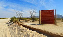
In recognition of its historic significance, El Camino del Diablo was listed on the
365:
In recognition of its historic significance, El Camino del Diablo was listed on the
1682:
University and college buildings listed on the
National Register of Historic Places
737:
705:
685:
568:
497:
351:
610:
1212:
931:
Sykes, Godfrey (1927). "The Camino Del Diablo: With Notes on a
Journey in 1925".
912:. Washington, DC: National Park Service, United States Department of the Interior
667:
579:
560:
556:
540:
520:
21:
762:
741:
253:
240:
659:
594:, established in 1939 to protect desert wildlife. With the exception of one
492:. The next Europeans known to have transited the route were in the party of
385:
350:. From the 16th to the 19th centuries, the road was used extensively by
564:
548:
516:
405:
397:
340:
1050:"Desert Duty: On the Line With the U.S. Border Patrol – Texas Monthly"
952:
857:
Cabeza Prieta National Wildlife Refuge Comprehensive Conservation Plan
1677:
List of jails and prisons on the National Register of Historic Places
786:
National Register of Historic Places listings in Yuma County, Arizona
781:
National Register of Historic Places listings in Pima County, Arizona
630:
528:
429:
401:
343:. The name refers to the harsh, unforgiving conditions on the trail.
539:. A second wave of Sonoran miners used the trail in the 1860s, when
149:
944:
828:
Broyles, Bill; Hartmann, Gayle Harrison; Sheridan, Thomas (2014).
681:, which roughly parallels the border for 120 miles (190 km).
646:
609:
504:, while avoiding most of the more hostile Native American tribes.
384:
804:
910:
NATIONAL REGISTER OF HISTORIC PLACES INVENTORY - NOMINATION FORM
1222:
15:
878:. New York, New York: Smithmark Publishers, Inc. p. 51.
535:
teams, mapping and cataloging the land purchased in the 1853
1758:
National Register of Historic Places in Yuma County, Arizona
1733:
Roads on the National Register of Historic Places in Arizona
684:
The current route begins 21 miles (34 km) southwest of
396:
The southern terminus of the original route was located in
1145:(Reprinted ed.). Tucson: University of Arizona Press.
862:
It has earned its name as the most deadly immigrant trail
618:, near Wellton, Arizona. At spur road to Tinajas Altas.
590:
in 1978. It can still be transited by visitors to the
1657:
1636:
1610:
1569:
1302:
1279:
History of the National Register of Historic Places
1256:
1064:"Camp Grip: The U.S. Border Patrol's Isolated Base"
290:
277:
269:
232:
222:
46:. Unsourced material may be challenged and removed.
1154:
547:trail was the 130-mile (210 km) stretch from
1310:List of U.S. National Historic Landmarks by state
515:of the 1770s. However, the 1781 uprising of the
456:. From Yuma Crossing, travelers could cross the
1702:National Register of Historic Places portal
1113:Cabeza Prieta National Wildlife Refuge (2013).
1234:
628:("high tanks") features nine cup-like pools (
307:, meaning "The Devil's Path"), also known as
8:
574:Use of the trail declined sharply after the
205:
180:
1004:. Bureau of Land Management. Archived from
773:National Register of Historic Places portal
654:helicopter along El Camino del Diablo, 2004
1241:
1227:
1219:
148:
1250:U.S. National Register of Historic Places
998:"El Camino del Diablo Back Country Byway"
968:"The Perils and Wonders of a True Desert"
899:
897:
895:
543:was discovered along the Colorado River.
533:United States and Mexican Boundary Survey
507:The route was used by the expeditions to
404:. From Caborca, the route passed through
137:U.S. National Register of Historic Places
106:Learn how and when to remove this message
471:
400:, in what is today the Mexican state of
1192:El Camino del Diablo Back Country Byway
834:. Univ. of Arizona Press. p. 140.
796:
658:Today, the Camino del Diablo remains a
369:in 1978. It has also been designated a
1768:Transportation in Pima County, Arizona
1763:Transportation in Yuma County, Arizona
1038:Cabeza Prieta National Wildlife Refuge
805:"National Register Information System"
694:Cabeza Prieta National Wildlife Refuge
592:Cabeza Prieta National Wildlife Refuge
412:, then through the lava fields of the
391:Cabeza Prieta National Wildlife Refuge
120:
1029:
1027:
1025:
700:, following the northern edge of the
696:. From there, it continues west past
7:
810:National Register of Historic Places
588:National Register of Historic Places
367:National Register of Historic Places
44:adding citations to reliable sources
876:The History of the Southern Pacific
690:Organ Pipe Cactus National Monument
1665:National Historic Preservation Act
1002:Autotouring & Pleasure Driving
730:Barry M. Goldwater Air Force Range
616:Barry M. Goldwater Air Force Range
488:through this vicinity en route to
428:, the route ran past the rain-fed
156:Barry M. Goldwater Air Force Range
14:
1178:Last Water on the Devil's Highway
1157:The Devil's Highway: A True Story
831:Last Water on the Devil's Highway
1707:
1706:
1695:
765:
204:
197:
179:
172:
20:
1738:History of Yuma County, Arizona
527:brought many new migrants from
31:needs additional citations for
1618:Federated States of Micronesia
1264:Architectural style categories
1180:. University of Arizona Press.
724:, before finally reaching the
462:Spanish colonies of California
424:. After passing just south of
279:
1:
1201:Trail guide and photo gallery
213:Show map of the United States
1143:Campfires on Desert and Lava
614:El Camino del Diablo in the
578:reached Yuma in 1870. While
448:before finally reaching the
154:El Camino del Diablo in the
118:United States historic place
1753:Mexico–United States border
675:Mexico–United States border
622:The historic campground at
596:United States Border Patrol
1784:
1670:Historic Preservation Fund
1649:American Legation, Morocco
1161:. Boston: Back Bay Books.
750:Fortuna Foothills, Arizona
736:, before finally reaching
688:, at the boundary between
643:El Camino del Diablo today
1690:
1611:Lists by associated state
1196:Bureau of Land Management
904:Wilson, Marjorie (1978).
679:Mexican Federal Highway 2
576:Southern Pacific Railroad
551:, Mexico, to what is now
375:Bureau of Land Management
356:Southern Pacific Railroad
278:NRHP reference
166:
147:
143:
134:
127:
123:
1592:Northern Mariana Islands
484:led a detachment of the
389:El Camino del Diablo in
984:2027/iau.31858055203552
966:Gaillard, D.D. (1896).
726:Tinajas Altas Mountains
438:Tinajas Altas Mountains
1748:Gran Desierto de Altar
1587:Minor Outlying Islands
1570:Lists by insular areas
1284:Keeper of the Register
906:"El Camino del Diablo"
655:
619:
498:Eusebio Francisco Kino
477:
393:
254:32.07222°N 113.38667°W
55:"El Camino del Diablo"
1289:National Park Service
1269:Contributing property
972:Cosmopolitan Magazine
860:. 2007. p. 193.
815:National Park Service
650:
613:
513:Juan Bautista de Anza
475:
388:
1644:District of Columbia
1213:El Camino del Diablo
1139:Hornaday, William T.
1034:El Camino del Diablo
874:Yenne, Bill (1996).
702:Agua Dulce Mountains
525:California Gold Rush
468:History of the trail
436:before crossing the
410:Quitobaquito Springs
309:El Camino del Muerto
301:El Camino del Diablo
259:32.07222; -113.38667
129:El Camino del Diablo
40:improve this article
933:Geographical Review
486:Coronado Expedition
440:through the nearby
416:, then through the
250: /
188:Show map of Arizona
1206:2009-09-04 at the
1052:. 21 January 2013.
718:Lechuguilla Desert
698:San Cristobal Wash
656:
620:
478:
442:Tinajas Altas Pass
394:
371:Back Country Byway
321:Yuma-Caborca Trail
317:Sonoyta-Yuma Trail
227:Lukeville, Arizona
1720:
1719:
1274:Historic district
841:978-0-8165-9887-8
817:. March 13, 2009.
722:Tordillo Mountain
426:Tordillo Mountain
298:
297:
116:
115:
108:
90:
1775:
1710:
1709:
1700:
1699:
1698:
1623:Marshall Islands
1243:
1236:
1229:
1220:
1181:
1172:
1160:
1146:
1126:
1125:
1123:
1122:
1110:
1104:
1103:Gaillard, p. 603
1101:
1095:
1094:
1092:
1091:
1082:
1074:
1068:
1067:
1060:
1054:
1053:
1046:
1040:
1031:
1020:
1019:
1014:
1013:
994:
988:
987:
963:
957:
956:
928:
922:
921:
919:
917:
901:
890:
889:
871:
865:
864:
852:
846:
845:
825:
819:
818:
801:
775:
770:
769:
768:
746:Wellton, Arizona
720:, just south of
664:four-wheel drive
567:, but also from
537:Gadsden Purchase
348:Native Americans
294:December 1, 1978
281:
265:
264:
262:
261:
260:
255:
251:
248:
247:
246:
243:
214:
208:
207:
201:
189:
183:
182:
176:
160:Wellton, Arizona
152:
121:
111:
104:
100:
97:
91:
89:
48:
24:
16:
1783:
1782:
1778:
1777:
1776:
1774:
1773:
1772:
1723:
1722:
1721:
1716:
1696:
1694:
1686:
1653:
1632:
1606:
1565:
1298:
1252:
1247:
1208:Wayback Machine
1188:
1175:
1169:
1149:
1137:
1134:
1132:Further reading
1129:
1120:
1118:
1112:
1111:
1107:
1102:
1098:
1089:
1087:
1080:
1076:
1075:
1071:
1066:. 16 June 2015.
1062:
1061:
1057:
1048:
1047:
1043:
1032:
1023:
1011:
1009:
996:
995:
991:
965:
964:
960:
930:
929:
925:
915:
913:
903:
902:
893:
886:
873:
872:
868:
854:
853:
849:
842:
827:
826:
822:
803:
802:
798:
794:
771:
766:
764:
761:
662:, suitable for
645:
608:
509:Alta California
502:Baja California
490:the Californias
470:
458:Colorado Desert
414:Sierra Pinacate
383:
258:
256:
252:
249:
244:
241:
239:
237:
236:
218:
217:
216:
215:
212:
211:
210:
209:
192:
191:
190:
187:
186:
185:
184:
162:
139:
130:
119:
112:
101:
95:
92:
49:
47:
37:
25:
12:
11:
5:
1781:
1779:
1771:
1770:
1765:
1760:
1755:
1750:
1745:
1743:Sonoran Desert
1740:
1735:
1725:
1724:
1718:
1717:
1715:
1714:
1704:
1691:
1688:
1687:
1685:
1684:
1679:
1674:
1673:
1672:
1661:
1659:
1655:
1654:
1652:
1651:
1646:
1640:
1638:
1634:
1633:
1631:
1630:
1625:
1620:
1614:
1612:
1608:
1607:
1605:
1604:
1602:Virgin Islands
1599:
1594:
1589:
1584:
1579:
1577:American Samoa
1573:
1571:
1567:
1566:
1564:
1563:
1558:
1553:
1548:
1543:
1538:
1533:
1528:
1523:
1518:
1513:
1511:South Carolina
1508:
1503:
1498:
1493:
1488:
1483:
1478:
1476:North Carolina
1473:
1468:
1463:
1458:
1453:
1448:
1443:
1438:
1433:
1428:
1423:
1418:
1413:
1408:
1403:
1398:
1393:
1388:
1383:
1378:
1373:
1368:
1363:
1358:
1353:
1348:
1343:
1338:
1333:
1328:
1323:
1318:
1313:
1306:
1304:
1303:Lists by state
1300:
1299:
1297:
1296:
1294:Property types
1291:
1286:
1281:
1276:
1271:
1266:
1260:
1258:
1254:
1253:
1248:
1246:
1245:
1238:
1231:
1223:
1217:
1216:
1210:
1198:
1187:
1186:External links
1184:
1183:
1182:
1173:
1168:978-0316010801
1167:
1147:
1133:
1130:
1128:
1127:
1105:
1096:
1069:
1055:
1041:
1021:
989:
958:
945:10.2307/208133
923:
891:
884:
866:
847:
840:
820:
795:
793:
790:
789:
788:
783:
777:
776:
760:
757:
734:Gila Mountains
714:Tule Mountains
644:
641:
607:
604:
469:
466:
450:Colorado River
446:Gila Mountains
422:Tule Mountains
382:
381:Original route
379:
352:conquistadores
329:Sonoran Desert
325:Old Yuma Trail
296:
295:
292:
288:
287:
282:
275:
274:
271:
267:
266:
234:
230:
229:
224:
220:
219:
203:
202:
196:
195:
194:
193:
178:
177:
171:
170:
169:
168:
167:
164:
163:
153:
145:
144:
141:
140:
135:
132:
131:
128:
125:
124:
117:
114:
113:
28:
26:
19:
13:
10:
9:
6:
4:
3:
2:
1780:
1769:
1766:
1764:
1761:
1759:
1756:
1754:
1751:
1749:
1746:
1744:
1741:
1739:
1736:
1734:
1731:
1730:
1728:
1713:
1705:
1703:
1693:
1692:
1689:
1683:
1680:
1678:
1675:
1671:
1668:
1667:
1666:
1663:
1662:
1660:
1656:
1650:
1647:
1645:
1642:
1641:
1639:
1635:
1629:
1626:
1624:
1621:
1619:
1616:
1615:
1613:
1609:
1603:
1600:
1598:
1595:
1593:
1590:
1588:
1585:
1583:
1580:
1578:
1575:
1574:
1572:
1568:
1562:
1559:
1557:
1554:
1552:
1551:West Virginia
1549:
1547:
1544:
1542:
1539:
1537:
1534:
1532:
1529:
1527:
1524:
1522:
1519:
1517:
1514:
1512:
1509:
1507:
1504:
1502:
1499:
1497:
1494:
1492:
1489:
1487:
1484:
1482:
1479:
1477:
1474:
1472:
1469:
1467:
1464:
1462:
1459:
1457:
1456:New Hampshire
1454:
1452:
1449:
1447:
1444:
1442:
1439:
1437:
1434:
1432:
1429:
1427:
1424:
1422:
1419:
1417:
1416:Massachusetts
1414:
1412:
1409:
1407:
1404:
1402:
1399:
1397:
1394:
1392:
1389:
1387:
1384:
1382:
1379:
1377:
1374:
1372:
1369:
1367:
1364:
1362:
1359:
1357:
1354:
1352:
1349:
1347:
1344:
1342:
1339:
1337:
1334:
1332:
1329:
1327:
1324:
1322:
1319:
1317:
1314:
1311:
1308:
1307:
1305:
1301:
1295:
1292:
1290:
1287:
1285:
1282:
1280:
1277:
1275:
1272:
1270:
1267:
1265:
1262:
1261:
1259:
1255:
1251:
1244:
1239:
1237:
1232:
1230:
1225:
1224:
1221:
1215:at Desert USA
1214:
1211:
1209:
1205:
1202:
1199:
1197:
1193:
1190:
1189:
1185:
1179:
1174:
1170:
1164:
1159:
1158:
1152:
1148:
1144:
1140:
1136:
1135:
1131:
1116:
1109:
1106:
1100:
1097:
1086:
1079:
1073:
1070:
1065:
1059:
1056:
1051:
1045:
1042:
1039:
1035:
1030:
1028:
1026:
1022:
1018:
1008:on 2016-05-11
1007:
1003:
999:
993:
990:
985:
981:
977:
973:
969:
962:
959:
954:
950:
946:
942:
938:
934:
927:
924:
911:
907:
900:
898:
896:
892:
887:
885:0-8317-3788-3
881:
877:
870:
867:
863:
859:
858:
851:
848:
843:
837:
833:
832:
824:
821:
816:
812:
811:
806:
800:
797:
791:
787:
784:
782:
779:
778:
774:
763:
758:
756:
753:
751:
747:
743:
739:
735:
731:
727:
723:
719:
715:
711:
707:
703:
699:
695:
691:
687:
682:
680:
676:
673:South of the
671:
669:
665:
661:
653:
652:Border Patrol
649:
642:
640:
637:
633:
632:
627:
626:
625:Tinajas Altas
617:
612:
606:Tinajas Altas
605:
603:
601:
597:
593:
589:
584:
581:
577:
572:
570:
566:
562:
558:
554:
553:Yuma, Arizona
550:
544:
542:
538:
534:
530:
526:
522:
518:
514:
510:
505:
503:
499:
495:
491:
487:
483:
474:
467:
465:
463:
460:to reach the
459:
455:
454:Yuma Crossing
451:
447:
443:
439:
435:
434:Tinajas Altas
431:
427:
423:
419:
415:
411:
407:
403:
399:
392:
387:
380:
378:
376:
372:
368:
363:
361:
357:
353:
349:
344:
342:
338:
334:
330:
326:
322:
318:
314:
310:
306:
302:
293:
291:Added to NRHP
289:
286:
283:
276:
272:
268:
263:
235:
231:
228:
225:
221:
200:
175:
165:
161:
157:
151:
146:
142:
138:
133:
126:
122:
110:
107:
99:
88:
85:
81:
78:
74:
71:
67:
64:
60:
57: –
56:
52:
51:Find sources:
45:
41:
35:
34:
29:This article
27:
23:
18:
17:
1516:South Dakota
1506:Rhode Island
1501:Pennsylvania
1481:North Dakota
1177:
1156:
1142:
1119:. Retrieved
1115:"Plan Ahead"
1108:
1099:
1088:. Retrieved
1084:
1072:
1058:
1044:
1016:
1010:. Retrieved
1006:the original
1001:
992:
975:
971:
961:
939:(1): 62–74.
936:
932:
926:
914:. Retrieved
909:
875:
869:
861:
856:
850:
830:
823:
808:
799:
754:
738:Interstate 8
706:Sierra Pinta
686:Ajo, Arizona
683:
672:
657:
635:
629:
623:
621:
585:
573:
569:hyperthermia
545:
506:
482:Melchor Díaz
479:
395:
364:
345:
324:
320:
316:
313:Sonora Trail
312:
308:
300:
299:
223:Nearest city
102:
93:
83:
76:
69:
62:
50:
38:Please help
33:verification
30:
1637:Other areas
1597:Puerto Rico
1431:Mississippi
1346:Connecticut
1151:Urrea, Luís
1085:www.cbp.gov
710:Tule Desert
580:prospectors
561:heat stroke
557:dehydration
541:placer gold
521:Pedro Fages
418:Tule Desert
337:Yuma County
333:Pima County
257: /
245:113°23′12″W
233:Coordinates
1727:Categories
1546:Washington
1466:New Mexico
1461:New Jersey
1336:California
1121:2014-12-28
1090:2023-06-25
1012:2016-05-28
978:(6): 602.
792:References
742:Gila River
66:newspapers
1556:Wisconsin
1521:Tennessee
1426:Minnesota
1401:Louisiana
1141:(1985) .
668:clearance
666:and high-
660:dirt road
600:Camp Grip
598:station (
362:in 1877.
242:32°4′20″N
96:July 2012
1712:Category
1541:Virginia
1491:Oklahoma
1471:New York
1446:Nebraska
1436:Missouri
1421:Michigan
1411:Maryland
1396:Kentucky
1376:Illinois
1351:Delaware
1341:Colorado
1331:Arkansas
1204:Archived
1153:(2005).
916:23 March
759:See also
740:and the
420:and the
358:reached
285:78000560
1658:Related
1561:Wyoming
1536:Vermont
1441:Montana
1381:Indiana
1361:Georgia
1356:Florida
1326:Arizona
1316:Alabama
1194:at the
636:tinajas
631:tinajas
565:sunburn
549:Sonoyta
517:Quechan
496:priest
432:of the
430:tinajas
408:, then
406:Sonoyta
398:Caborca
373:by the
341:Arizona
305:Spanish
158:, near
80:scholar
1496:Oregon
1451:Nevada
1391:Kansas
1366:Hawaii
1321:Alaska
1257:Topics
1165:
953:208133
951:
882:
838:
563:, and
529:Mexico
494:Jesuit
402:Sonora
323:, and
82:
75:
68:
61:
53:
1628:Palau
1526:Texas
1406:Maine
1371:Idaho
1081:(PDF)
949:JSTOR
270:Built
87:JSTOR
73:books
1582:Guam
1531:Utah
1486:Ohio
1386:Iowa
1163:ISBN
918:2021
880:ISBN
836:ISBN
712:and
692:and
360:Yuma
335:and
273:1699
59:news
1036:at
980:hdl
941:doi
744:at
511:of
452:at
331:in
280:No.
42:by
1729::
1083:.
1024:^
1015:.
1000:.
976:21
974:.
970:.
947:.
937:17
935:.
908:.
894:^
813:.
807:.
752:.
559:,
464:.
377:.
339:,
319:,
315:,
311:,
1312::
1242:e
1235:t
1228:v
1171:.
1124:.
1093:.
986:.
982::
955:.
943::
920:.
888:.
844:.
303:(
109:)
103:(
98:)
94:(
84:·
77:·
70:·
63:·
36:.
Text is available under the Creative Commons Attribution-ShareAlike License. Additional terms may apply.