42:
653:
29:
49:
487:
280:
In 1955 the lake, and a minor part of the lake shores, were designated a national park. The park, including the lake, covers an area of 0.73 km² and is managed by the
National Forestry Institute (INAB) in conjunction with representatives of the local population. 20% of the lake shores are
454:
695:
519:
639:
458:
690:
215:
197:. The lake has a surface area of 0.72 km² and a maximum depth of 18 m. The lake waters are used for subsistence fishing, sport fishing, and swimming.
389:
700:
512:
88:
685:
505:
528:
41:
422:
228:
194:
74:
629:
599:
680:
491:
559:
609:
393:
624:
619:
614:
214:
594:
564:
326:
320:
308:
290:
544:
341:
554:
120:
353:
296:
658:
579:
569:
539:
359:
549:
574:
365:
285:
186:
134:
429:
674:
589:
584:
347:
28:
648:
497:
302:
103:
90:
314:
232:
190:
182:
70:
486:
339:
Species of waterfowl breeding in the lake area include Pied-billed Grebe (
121:
604:
634:
332:
178:
501:
336:
species. The surrounding area has coffee plantations.
270:
262:
254:
246:
238:
224:
207:
164:
156:
148:
144:
133:
119:
80:
66:
21:
696:Geography of the Santa Rosa Department, Guatemala
281:government property and 80% is privately owned.
81:
312:). The lake shores have some wooded areas with
284:Vegetation consists mainly of floating beds of
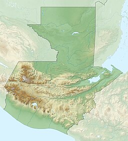
185:. It is located 30 km south-southeast of
513:
8:
455:"Listado de Áreas Protegidas (enero, 2011)"
520:
506:
498:
457:(in Spanish). conap.gob.gt. Archived from
204:
18:
417:
415:
413:
384:
382:
378:
300:), and marshy areas with Spikerushes (
7:
223:
48:
691:Protected areas established in 1955
242:0.73 km (0.28 sq mi)
152:0.72 km (0.28 sq mi)
14:
392:. Ducks Unlimited. Archived from
294:), submergent beds of Waterweed (
701:1955 establishments in Guatemala
651:
485:
213:
47:
40:
27:
253:
163:
155:
147:
428:. wetlands.org. Archived from
1:
65:
250:1,022 m (3,353 ft)
208:Laguna El Pino National Park
201:Laguna El Pino National Park
168:1,022 m (3,353 ft)
686:National parks of Guatemala
529:National parks of Guatemala
717:
646:
535:
423:"Wetland Inv - Guatemala"
390:"Wetland Inv - Guatemala"
212:
189:, in the municipality of
35:
26:
258:Ac. Gubernativo 26-05-55
363:) and Northern Jacana (
229:Santa Rosa (department)
615:Riscos de Momostenango
160:18 m (59 ft)
306:) and Giant Bulrush (
195:Santa Rosa Department
128:several small streams
104:14.34444°N 90.39389°W
494:at Wikimedia Commons
321:Cupressus lusitanica
309:Scirpus californicus
291:Eichhornia crassipes
640:Yaxhá-Nakúm-Naranjo
625:Sierra del Lacandón
620:San José la Colonia
545:Cerro El Reformador
342:Podilymbus podiceps
109:14.34444; -90.39389
100: /
681:Lakes of Guatemala
555:Cuevas del Silvino
357:), American Coot (
303:Eleocharis elegans
668:
667:
565:Grutas de Lanquín
490:Media related to
354:Gallinula galeata
297:Elodea canadensis
278:
277:
172:
171:
165:Surface elevation
16:Lake in Guatemala
708:
661:
659:Guatemala portal
656:
655:
654:
630:Sipacate-Naranjo
595:Mirador Río Azul
570:Laguna del Tigre
522:
515:
508:
499:
489:
473:
472:
470:
469:
463:
450:
444:
443:
441:
440:
435:on July 28, 2011
434:
427:
419:
408:
407:
405:
404:
398:
386:
360:Fulica americana
217:
205:
123:
115:
114:
112:
111:
110:
105:
101:
98:
97:
96:
93:
83:
51:
50:
44:
31:
19:
716:
715:
711:
710:
709:
707:
706:
705:
671:
670:
669:
664:
657:
652:
650:
644:
600:Naciones Unidas
550:Cerro Miramundo
531:
526:
482:
477:
476:
467:
465:
461:
452:
451:
447:
438:
436:
432:
425:
421:
420:
411:
402:
400:
396:
388:
387:
380:
375:
327:Inga xalapensis
220:
203:
137: countries
122:Primary inflows
108:
106:
102:
99:
94:
91:
89:
87:
86:
62:
61:
60:
59:
58:
57:
56:
52:
17:
12:
11:
5:
714:
712:
704:
703:
698:
693:
688:
683:
673:
672:
666:
665:
663:
662:
647:
645:
643:
642:
637:
632:
627:
622:
617:
612:
607:
602:
597:
592:
587:
582:
577:
575:Laguna El Pino
572:
567:
562:
557:
552:
547:
542:
536:
533:
532:
527:
525:
524:
517:
510:
502:
496:
495:
492:Laguna El Pino
481:
480:External links
478:
475:
474:
445:
409:
377:
376:
374:
371:
366:Jacana spinosa
286:Water Hyacinth
276:
275:
272:
268:
267:
264:
260:
259:
256:
252:
251:
248:
244:
243:
240:
236:
235:
226:
222:
221:
219:Jacana spinosa
218:
210:
209:
202:
199:
187:Guatemala City
170:
169:
166:
162:
161:
158:
154:
153:
150:
146:
145:
142:
141:
138:
131:
130:
125:
117:
116:
84:
78:
77:
68:
64:
63:
54:
53:
46:
45:
39:
38:
37:
36:
33:
32:
24:
23:
15:
13:
10:
9:
6:
4:
3:
2:
713:
702:
699:
697:
694:
692:
689:
687:
684:
682:
679:
678:
676:
660:
649:
641:
638:
636:
633:
631:
628:
626:
623:
621:
618:
616:
613:
611:
608:
606:
603:
601:
598:
596:
593:
591:
590:Los Aposentos
588:
586:
585:Las Victorias
583:
581:
580:Laguna Lachuá
578:
576:
573:
571:
568:
566:
563:
561:
558:
556:
553:
551:
548:
546:
543:
541:
540:Cerro El Baúl
538:
537:
534:
530:
523:
518:
516:
511:
509:
504:
503:
500:
493:
488:
484:
483:
479:
464:on 2011-10-08
460:
456:
449:
446:
431:
424:
418:
416:
414:
410:
399:on 2016-03-03
395:
391:
385:
383:
379:
372:
370:
368:
367:
362:
361:
356:
355:
351:), Waterhen (
350:
349:
348:Bubulcus ibis
344:
343:
337:
335:
334:
329:
328:
323:
322:
317:
316:
311:
310:
305:
304:
299:
298:
293:
292:
287:
282:
273:
269:
265:
261:
257:
249:
245:
241:
237:
234:
230:
227:
216:
211:
206:
200:
198:
196:
192:
188:
184:
180:
176:
167:
159:
151:
143:
139:
136:
132:
129:
126:
124:
118:
113:
85:
79:
76:
72:
69:
43:
34:
30:
25:
20:
466:. Retrieved
459:the original
448:
437:. Retrieved
430:the original
401:. Retrieved
394:the original
364:
358:
352:
346:
340:
338:
331:
325:
319:
313:
307:
301:
295:
289:
283:
279:
175:El Pino Lake
174:
173:
149:Surface area
127:
55:El Pino Lake
22:El Pino Lake
255:Established
107: /
82:Coordinates
675:Categories
560:El Rosario
468:2011-06-14
439:2009-06-11
403:2009-06-11
373:References
345:), Egret (
157:Max. depth
95:90°23′38″W
92:14°20′40″N
75:Santa Rosa
610:Río Dulce
318:species,
315:Casuarina
247:Elevation
233:Guatemala
191:Barberena
183:Guatemala
140:Guatemala
71:Barberena
271:Operator
263:Visitors
225:Location
67:Location
453:CONAP.
266:allowed
193:in the
605:Pacaya
635:Tikal
462:(xls)
433:(pdf)
426:(PDF)
397:(xls)
333:Pinus
177:is a
135:Basin
330:and
274:INAB
239:Area
179:lake
369:).
181:in
677::
412:^
381:^
324:,
231:,
73:,
521:e
514:t
507:v
471:.
442:.
406:.
288:(
Text is available under the Creative Commons Attribution-ShareAlike License. Additional terms may apply.