295:
28:
283:
264:
239:. Since in pre-modern times the valleys of the Spessart were often swampy and water-logged, the path stuck to the higher elevations. This route also avoided the need for constant climbing into and out of the river valleys. The route's name derives from the caravans of donkeys used in the
305:
The modern hiking trail mostly follows the historic route and crosses the
Spessart as a high route which sticks to the peaks and ridges and avoids the valleys and villages. It is maintained and signposted by the
423:
For most of its length after the initial climb the trail stays at an elevation between 400 m and 500 m and sports few significant climbs. It mostly passes through
665:
511:
619:
586:
561:
660:
388:
675:
650:
247:
to
Miltenberg, where it was either loaded on ships or carried on by land. Miltenberg was an important toll station set up by the
655:
645:
196:. The trail follows an ancient trade route on which donkey caravans used to transport salt, thus giving rise to the name.
377:
before looping west and south back to the
Autobahn at Rohrbrunn, a possible location of the inn that inspired a story by
635:
334:. It then climbs from the Kinzig valley into the Spessart hills and goes roughly southwest and then south. Near the
467:
412:
436:
347:
228:
424:
233:
393:
406:
398:
515:
357:
248:
335:
308:
670:
615:
582:
557:
345:, it reaches the Bavarian border and follows it west before turning south again, entering the
215:
440:
383:
294:
432:
431:) and Weibersbrunn. It also passes quite close to the villages of Flörsbach (a part of
27:
640:
327:
189:
181:
76:
72:
340:
629:
378:
205:
185:
161:
489:
282:
374:
193:
156:
126:
219:
313:
331:
240:
134:
370:
263:
223:
428:
427:. The only villages the trail directly touches are: Lettgenbrunn (a part of
67:
95:
2,071 metres (6,790 ft) gain in; 2,078 metres (6,820 ft) gain out
165:
369:
continues to lead mostly in a southerly direction, until it crosses the
290:
near
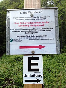
Heigenbrücken due to forestry work conducted by Deutsche Bahn, 2013
244:
177:
173:
116:
60:
211:
has likely been in use since prehistoric times. It may have connected
293:
281:
262:
212:
169:
416:, above Großheubach and then leads down over 600 steps (
111:
212 m above sea level (western start near Schlüchtern)
404:, and snakes southwards and southwest, entering the
141:
125:
115:
107:
99:
91:
83:
66:
48:
40:
18:
361:. The two trails run alongside each other to the
539:Grieben Reiseführer, Band 137: Spessart (German)
159:that follows an ancient trade route through the
226:to similar places near the Kinzig, such as the
355:also touches another ancient trade route, the
255:was first mentioned in 1339 as "Eßelspfadt".
155:(English: "donkey trail") is a long-distance
8:
326:hiking trail starts at the train station of
387:. The trail passes a hunting lodge used by
462:
460:
458:
456:
180:. It is 111 km long and leads from
452:
103:525 m above sea level (east of Bad Orb)
579:Kompass Wanderführer Spessart (German)
15:
554:Rother Wanderführer Spessart (German)
7:
666:Historic trails and roads in Germany
514:. Naturpark Spessart. Archived from
410:. It reaches the Main valley at the
614:(German) CoCon-Verlag, Hanau 2009,
612:Der Eselsweg. Wandern im Spessart.
581:. Kompass Karten GmbH, Innsbruck.
389:Luitpold, Prince Regent of Bavaria
14:
26:
556:. Bergverlag Rother, München.
58:Naturpark Bayerischer Spessart
1:
53:Naturpark Hessischer Spessart
365:, where they part ways. The
286:Official detour sign on the
79:, numerous places in between
537:Thiemig, Karl, ed. (1972).
435:) and Wildensee (a part of
319:with a black "E" on white.
692:
552:Tubbesing, Ulrich (2010).
541:. Grieben Verlag, München.
661:Medieval roads and tracks
470:. Deutscher Wanderverband
25:
676:Hiking trails in Bavaria
651:Aschaffenburg (district)
577:Frosch, Norbert (2010).
44:111 km (69 mi)
425:mixed coniferous forest
348:Landkreis Aschaffenburg
243:to transport salt from
218:, found for example at
656:Hiking trails in Hesse
302:
291:
279:
646:Miltenberg (district)
394:Schloss Luitpoldshöhe
299:Schloss Luitpoldshöhe
297:
285:
266:
184:in the valley of the
610:Brigitte Wenninger:
407:Landkreis Miltenberg
358:Birkenhainer Strasse
351:. In this area, the
276:Birkenhainer Strasse
131:natural paths (35%),
636:Former trade routes
512:"Eselsweg (German)"
490:"Eselsweg (German)"
468:"Eselsweg (German)"
249:Archbishop of Mainz
168:, in the states of
145:www.spessartbund.de
92:Elevation gain/loss
303:
292:
280:
137:(60%), tarmac (5%)
121:black "E" on white
620:978-3-937774-74-9
588:978-3-85026-219-4
563:978-3-7633-4269-3
443:, a larger town.
420:) into the town.
413:Kloster Engelberg
216:circular ramparts
149:
148:
683:
593:
592:
574:
568:
567:
549:
543:
542:
534:
528:
527:
525:
523:
508:
502:
501:
499:
497:
486:
480:
479:
477:
475:
464:
439:) as well as to
402:
384:The Spessart Inn
344:
317:
237:
30:
16:
691:
690:
686:
685:
684:
682:
681:
680:
626:
625:
607:
605:Further reading
602:
597:
596:
589:
576:
575:
571:
564:
551:
550:
546:
536:
535:
531:
521:
519:
518:on 26 July 2015
510:
509:
505:
495:
493:
488:
487:
483:
473:
471:
466:
465:
454:
449:
396:
338:
311:
261:
231:
202:
132:
56:
36:
12:
11:
5:
689:
687:
679:
678:
673:
668:
663:
658:
653:
648:
643:
638:
628:
627:
624:
623:
606:
603:
601:
600:External links
598:
595:
594:
587:
569:
562:
544:
529:
503:
492:. Spessartbund
481:
451:
450:
448:
445:
418:Engelsstaffeln
381:and the movie
363:Dr.-Kihn-Platz
301:near Rohrbrunn
268:Dr.-Kihn-Platz
260:
257:
201:
198:
147:
146:
143:
139:
138:
129:
123:
122:
119:
113:
112:
109:
105:
104:
101:
97:
96:
93:
89:
88:
85:
81:
80:
70:
64:
63:
50:
46:
45:
42:
38:
37:
35:near Rohrbrunn
31:
23:
22:
13:
10:
9:
6:
4:
3:
2:
688:
677:
674:
672:
669:
667:
664:
662:
659:
657:
654:
652:
649:
647:
644:
642:
639:
637:
634:
633:
631:
621:
617:
613:
609:
608:
604:
599:
590:
584:
580:
573:
570:
565:
559:
555:
548:
545:
540:
533:
530:
517:
513:
507:
504:
491:
485:
482:
469:
463:
461:
459:
457:
453:
446:
444:
442:
441:Heigenbrücken
438:
434:
430:
426:
421:
419:
415:
414:
409:
408:
403:
400:
395:
390:
386:
385:
380:
379:Wilhelm Hauff
376:
372:
368:
364:
360:
359:
354:
350:
349:
342:
337:
333:
329:
325:
320:
318:
315:
310:
300:
296:
289:
284:
277:
273:
269:
265:
258:
256:
254:
250:
246:
242:
238:
235:
230:
225:
221:
217:
214:
210:
207:
206:historic road
199:
197:
195:
192:on the river
191:
187:
183:
179:
175:
171:
167:
164:
163:
162:Mittelgebirge
158:
154:
144:
140:
136:
130:
128:
124:
120:
118:
114:
110:
106:
102:
100:Highest point
98:
94:
90:
86:
82:
78:
74:
71:
69:
65:
62:
59:
54:
51:
47:
43:
39:
34:
29:
24:
21:
17:
611:
578:
572:
553:
547:
538:
532:
520:. Retrieved
516:the original
506:
494:. Retrieved
484:
472:. Retrieved
433:Flörsbachtal
422:
417:
411:
405:
392:
382:
375:Weibersbrunn
366:
362:
356:
352:
346:
336:Wiesbüttmoor
323:
321:
309:Spessartbund
307:
304:
298:
287:
275:
271:
267:
252:
227:
208:
203:
186:Kinzig river
160:
157:hiking trail
152:
150:
135:forest roads
108:Lowest point
57:
52:
32:
19:
522:3 September
496:3 September
474:3 September
397: [
339: [
332:Main-Kinzig
328:Schlüchtern
312: [
241:Middle Ages
232: [
190:Großheubach
182:Schlüchtern
77:Großheubach
73:Schlüchtern
630:Categories
447:References
371:Autobahn 3
224:Miltenberg
133:gravel on
68:Trailheads
429:Jossgrund
220:Bürgstadt
671:Spessart
367:Eselsweg
353:Eselsweg
324:Eselsweg
288:Eselsweg
272:Eselsweg
253:Eselsweg
229:Alteburg
209:Eselsweg
166:Spessart
153:Eselsweg
49:Location
33:Eselsweg
20:Eselsweg
200:History
178:Germany
174:Bavaria
142:Website
127:Surface
117:Waymark
61:Germany
618:
585:
560:
437:Eschau
270:where
251:. The
213:Celtic
87:Hiking
41:Length
641:Hesse
401:]
343:]
316:]
259:Route
236:]
170:Hesse
616:ISBN
583:ISBN
558:ISBN
524:2015
498:2015
476:2015
322:The
278:meet
274:and
222:and
204:The
194:Main
172:and
151:The
373:at
245:Orb
188:to
84:Use
632::
455:^
399:de
391:,
341:de
330:,
314:de
234:de
176:,
75:,
55:,
622:.
591:.
566:.
526:.
500:.
478:.
Text is available under the Creative Commons Attribution-ShareAlike License. Additional terms may apply.