226:
233:
205:
177:
198:
393:
170:
40:
453:
381:
465:
429:
405:
441:
417:
339:
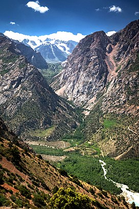
The Fanns boast about a hundred peaks, with several rising to altitudes of more than 5,000 meters and relative elevations of up to 1,500 meters. The highest point in Fann
Mountains is Chimtarga peak (5,489 m). Other 5,000-meter peaks are Bodkhona (5,138 m), Chapdara (5,050 m), Big Hansa, Little Hansa
354:
There is a stunning mountain range in
Western Tajikistan, near the city of Punjikent, which surprises tourists with its vivid, ever-changing colours. This are known as the Seven Lakes, Haftkul, or even Marguzor Lakes. In Tadjiki it means seven lakes (named after the largest lake in the group).
225:
358:
The best time for visiting is late June–mid-September for trekking and July–August for mountaineering, when the weather is usually at its best. Access is generally from
621:
616:
197:
79:
169:
392:
452:
72:
380:
514:
464:
62:
297:
440:
510:
428:
404:
343:
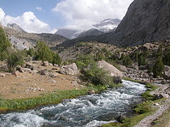
There are many lakes in the Fanns.The best known are
Alaudin lakes in the Chapdara River valley,
416:
39:
574:
348:
490:
344:
320:
528:
316:
288:
268:
145:
130:
610:
553:
324:
485:
312:
308:
275:
261:
257:
94:
81:
17:
367:
359:
328:
363:
340:(5,031 m), Zamok ('5,070 m), Mirali (5,132 m), and Energia (5,120 m).
52:
601:
327:
to the south. In an east-west direction, they extend from the
347:
on the northern slope of
Chimtarga peak, Big Allo Lake and
602:
1:100,000 topographical tourist map of the Fann
Mountains
302:
267:
253:
156:
115:
110:
71:
61:
51:
46:
32:
8:
137:
122:
29:
502:
376:
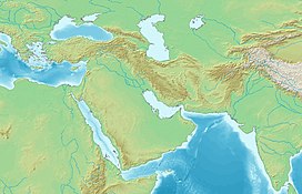
240:Fann Mountains (West and Central Asia)
232:
204:
176:
7:
362:, which can be reached either from
575:"Fann mountains trekking: a guide"
515:"Zigzagging in the Fann Mountains"
25:
243:Show map of West and Central Asia
463:
451:
439:
427:
415:
403:
391:
379:
231:
224:
203:
196:
175:
168:
38:
184:Location in Western Tajikistan
1:
622:Mountain ranges of Uzbekistan
617:Mountain ranges of Tajikistan
57:5,489 m (18,009 ft)
303:
212:Fann Mountains (Uzbekistan)
638:
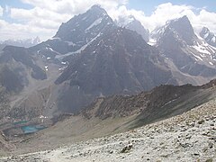
398:Chapdara and Bodhona Peaks
331:to the Archimaydan River.
307:) are part of the western
458:Village in Fann Mountains
292:
161:
123:
37:
386:Fann Mountains Trekking
335:Peaks, lakes and access
95:39.166667°N 68.250000°E
27:Mountains in Tajikistan
517:. Stanford University.
215:Show map of Uzbekistan
187:Show map of Tajikistan
138:
323:to the north and the
533:TravelTajikistan.net
511:Latombe, Jean-Claude
100:39.166667; 68.250000
311:mountain system in
91: /
47:Highest point
477:
476:
301:
281:
280:
16:(Redirected from
629:
589:
588:
586:
585:
571:
565:
564:
562:
560:
550:
544:
543:
541:
539:
529:"Fann mountains"
525:
519:
518:
507:
467:
455:
443:
431:
419:
407:
395:
383:
373:
372:
349:Iskanderkul Lake
306:
296:
294:
271:
244:
235:
234:
228:
216:
207:
206:
200:
188:
179:
178:
172:
149:
141:
134:
126:
125:
106:
105:
103:
102:
101:
96:
92:
89:
88:
87:
84:
42:
30:
21:
637:
636:
632:
631:
630:
628:
627:
626:
607:
606:
598:
593:
592:
583:
581:
573:
572:
568:
558:
556:
552:
551:
547:
537:
535:
527:
526:
522:
509:
508:
504:
499:
491:Pamir Mountains
482:
471:
468:
459:
456:
447:
446:People of Fanns
444:
435:
432:
423:
420:
411:
408:
399:
396:
387:
384:
345:Kulikalon Lakes
337:
321:Zarafshan Range
269:
249:
248:
247:
246:
245:
242:
241:
238:
237:
236:
219:
218:
217:
214:
213:
210:
209:
208:
191:
190:
189:
186:
185:
182:
181:
180:
152:
143:
128:
99:
97:
93:
90:
85:
82:
80:
78:
77:
28:
23:
22:
15:
12:
11:
5:
635:
633:
625:
624:
619:
609:
608:
605:
604:
597:
596:External links
594:
591:
590:
566:
545:
520:
501:
500:
498:
495:
494:
493:
488:
486:Alay Mountains
481:
478:
475:
474:
473:
472:
469:
462:
460:
457:
450:
448:
445:
438:
436:
434:Chimtarga Peak
433:
426:
424:
421:
414:
412:
409:
402:
400:
397:
390:
388:
385:
378:
336:
333:
319:, between the
317:Sughd Province
285:Fann Mountains
279:
278:
273:
265:
264:
255:
251:
250:
239:
230:
229:
223:
222:
221:
220:
211:
202:
201:
195:
194:
193:
192:
183:
174:
173:
167:
166:
165:
164:
163:
162:
159:
158:
154:
153:
151:
150:
135:
119:
117:
113:
112:
108:
107:
75:
69:
68:
67:Chimtarga Peak
65:
59:
58:
55:
49:
48:
44:
43:
35:
34:
33:Fann Mountains
26:
24:
14:
13:
10:
9:
6:
4:
3:
2:
634:
623:
620:
618:
615:
614:
612:
603:
600:
599:
595:
580:
576:
570:
567:
555:
549:
546:
534:
530:
524:
521:
516:
512:
506:
503:
496:
492:
489:
487:
484:
483:
479:
466:
461:
454:
449:
442:
437:
430:
425:
418:
413:
410:Alaudin lakes
406:
401:
394:
389:
382:
377:
375:
374:
371:
369:
365:
361:
356:
352:
350:
346:
341:
334:
332:
330:
326:
322:
318:
314:
310:
305:
299:
290:
286:
277:
274:
272:
266:
263:
259:
256:
252:
227:
199:
171:
160:
155:
147:
140:
136:
132:
121:
120:
118:
114:
109:
104:
76:
74:
70:
66:
64:
60:
56:
54:
50:
45:
41:
36:
31:
19:
18:Fan Mountains
582:. Retrieved
579:Caravanistan
578:
569:
557:. Retrieved
554:"Seven Lake"
548:
538:15 September
536:. Retrieved
532:
523:
505:
422:Lake Moutniy
357:
353:
342:
338:
325:Gissar Range
284:
282:
270:Parent range
139:Fon togʻlari
86:68°15′00.0″E
83:39°10′00.0″N
470:Iskanderkul
116:Native name
98: /
73:Coordinates
63:Parent peak
611:Categories
584:2020-02-26
497:References
313:Tajikistan
309:Pamir-Alay
304:Kúhhoi Fon
293:Кӯҳҳои Фон
276:Pamir-Alay
262:Uzbekistan
258:Tajikistan
124:Кӯҳҳои Фон
559:March 31,
368:Samarkand
360:Panjakent
329:Fan Darya
298:romanized
157:Geography
53:Elevation
480:See also
364:Dushanbe
254:Location
300::
142:
127:
111:Naming
289:Tajik
146:Uzbek
131:Tajik
561:2021
540:2015
283:The
260:and
366:or
315:'s
613::
577:.
531:.
513:.
370:.
351:.
295:,
291::
587:.
563:.
542:.
287:(
148:)
144:(
133:)
129:(
20:)
Text is available under the Creative Commons Attribution-ShareAlike License. Additional terms may apply.