228:
295:
309:
240:
192:
72:
115:
Original title: "Views of
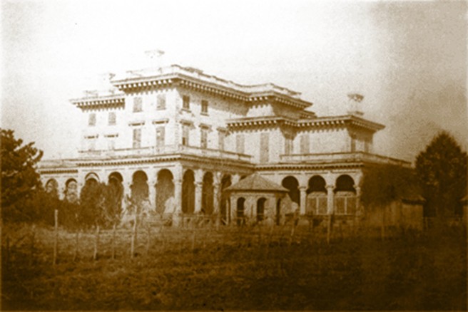
Anandale, A Famous Old Times Plantation Homestead." Supplemental: Side and rear view of the mansion at Annandale Plantation in Mannsdale, Madison County, Mississippi. Built from 1857 to 1859 by Jacob Larmour for Margaret Johnstone. Design taken from Plate IV of Minard
653:{{Information |Description=Original title: "Views of Anandale, A Famous Old Times Plantation Homestead." Supplemental: The mansion at Annandale Plantation in Mannsdale, Madison County, Mississippi. Built from 1857 to 1859 by Jacob Larmour for Margaret Jo
636:
254:
for US works, such as Canada, Mainland China (not Hong Kong or Macao), Germany, Mexico, and
Switzerland. The creator and year of publication are essential information and must be provided. See
120:, published in 1856. Largely unoccupied after Mrs. Johnstones death in 1880, it burned to the ground on September 9, 1924. A Classical Revival style house was later built at the site.
286:
43:
250:
This image might not be in the public domain outside of the United States; this especially applies in the countries and areas that do not apply the
159:
672:
83:
51:
469:
302:
703:
This file contains additional information, probably added from the digital camera or scanner used to create or digitize it.
564:
527:
490:
435:
401:
367:
462:
350:
255:
251:
259:
706:
If the file has been modified from its original state, some details may not fully reflect the modified file.
663:
The following pages on the
English Knowledge (XXG) use this file (pages on other projects are not listed):
667:
91:
635:
630:
217:
42:
646:
216:
occurred prior to
January 1, 1929, and if not then due to lack of notice or renewal. See
308:
204:
212:. This applies to U.S. works where the copyright has expired, often because its first
78:
292:
213:
209:
603:
Click on a date/time to view the file as it appeared at that time.
360:
294:
287:
32° 30′ 55.18″ N, 90° 11′ 09.25″ W
277:
186:
66:
238:
226:
190:
334:
Add a one-line explanation of what this file represents
690:
105:
90:
Commons is a freely licensed media file repository.
56:(656 × 438 pixels, file size: 65 KB, MIME type:
139:Mississippi Department of Archives and History
71:
8:
708:
605:
330:
166:
683:The following other wikis use this file:
451:27f6d05ec9ade8c5a14f1b499b4c5cac9ccdcd2a
710:
665:
578:
562:
541:
525:
504:
488:
449:
433:
415:
399:
381:
365:
348:
345:
326:
319:
280:
301:View this and other nearby images on:
227:
191:
7:
594:
701:
673:List of plantations in Mississippi
339:
333:
249:
200:
103:
49:
338:
130:date QS:P,+1910-00-00T00:00:00Z/8
368:coordinates of the point of view
324:
307:
293:
70:
31:
21:
321:
46:No higher resolution available.
14:
320:
26:
1:
383:32°30'55.177"N, 90°11'9.254"W
256:Knowledge (XXG):Public domain
36:
346:Items portrayed in this file
111:Annandale Plantation 02.jpg
52:Annandale_Plantation_02.jpg
732:
687:Usage on www.wikidata.org
260:Knowledge (XXG):Copyrights
202:This media file is in the
595:
16:
323:
252:rule of the shorter term
220:for further explanation.
118:Architectural Instructor
77:This is a file from the
652:
154:
143:
135:
127:
124:
108:
81:. Information from its
631:02:46, 15 January 2011
313:32.515327; -90.185904
243:
232:
196:
84:description page there
242:
230:
194:
668:Annandale Plantation
463:determination method
244:
233:
197:
719:
718:
679:Global file usage
656:
332:
318:
317:
275:
274:
271:
270:
264:
262:for more details.
185:
184:
163:
160:Reusing this file
99:
98:
79:Wikimedia Commons
32:Global file usage
723:
709:
643:
583:
546:
509:
472:
467:
314:
311:
297:
296:
290:
289:
278:
265:
248:
241:
229:
193:
187:
181:
178:
175:
172:
167:
157:
150:
112:
106:
95:
74:
73:
67:
61:
59:
731:
730:
726:
725:
724:
722:
721:
720:
697:
677:
664:
657:
649:
641:
597:
596:
593:
592:
591:
590:
589:
588:
587:
586:
584:
581:
571:
570:
569:
567:
556:
555:
554:
553:
552:
551:
550:
549:
547:
544:
534:
533:
532:
530:
519:
518:
517:
516:
515:
514:
513:
512:
510:
507:
497:
496:
495:
493:
482:
481:
480:
479:
478:
477:
476:
475:
474:
473:
468:
465:
456:
455:
454:
452:
442:
441:
440:
438:
427:
426:
425:
424:
423:
422:
421:
420:
418:
408:
407:
406:
404:
393:
392:
391:
390:
389:
388:
387:
386:
384:
374:
373:
372:
370:
359:
358:
357:
356:
355:
353:
337:
336:
335:
312:
285:
284:
281:Camera location
276:
263:
247:
239:
222:
179:
176:
173:
170:
148:
131:
110:
101:
100:
89:
88:
87:is shown below.
63:
57:
55:
48:
47:
12:
11:
5:
729:
727:
717:
716:
713:
700:
696:
695:
694:
693:
681:
680:
676:
675:
670:
662:
661:
660:
655:
654:
651:
647:
644:
638:
633:
628:
624:
623:
620:
617:
614:
611:
608:
601:
600:
585:
579:
577:
576:
575:
574:
573:
572:
568:
563:
561:
560:
559:
558:
557:
548:
542:
540:
539:
538:
537:
536:
535:
531:
526:
524:
523:
522:
521:
520:
511:
505:
503:
502:
501:
500:
499:
498:
494:
489:
487:
486:
485:
484:
483:
461:
460:
459:
458:
457:
453:
450:
448:
447:
446:
445:
444:
443:
439:
434:
432:
431:
430:
429:
428:
419:
416:
414:
413:
412:
411:
410:
409:
405:
400:
398:
397:
396:
395:
394:
385:
382:
380:
379:
378:
377:
376:
375:
371:
366:
364:
363:
362:
361:
354:
349:
347:
344:
343:
342:
341:
340:
329:
328:
325:
322:
316:
315:
305:
299:
282:
273:
272:
269:
268:
266:
245:
235:
234:
224:
198:
183:
182:
164:
152:
151:
149:Unknown author
147:Unknown author
145:
141:
140:
137:
133:
132:
129:
126:
122:
121:
113:
104:
102:
97:
96:
75:
65:
64:
45:
41:
40:
39:
34:
29:
24:
19:
13:
10:
9:
6:
4:
3:
2:
728:
714:
711:
707:
704:
698:
692:
689:
688:
686:
685:
684:
678:
674:
671:
669:
666:
658:
650:
645:
639:
637:
634:
632:
629:
626:
625:
621:
618:
615:
612:
609:
607:
606:
604:
598:
566:
529:
492:
471:
464:
437:
403:
369:
352:
310:
306:
304:
303:OpenStreetMap
300:
298:
288:
283:
279:
267:
261:
257:
253:
246:
237:
236:
231:United States
225:
223:
221:
219:
215:
211:
210:United States
207:
206:
205:public domain
199:
195:Public domain
189:
188:
174:Public domain
171:Public domain
169:
168:
165:
161:
156:
153:
146:
142:
138:
134:
123:
119:
114:
107:
93:
86:
85:
80:
76:
69:
68:
62:
53:
44:
38:
35:
33:
30:
28:
25:
23:
20:
18:
15:
705:
702:
682:
602:
599:File history
203:
201:
117:
92:You can help
82:
50:
22:File history
648:Altairisfar
214:publication
109:Description
712:_error
659:File usage
640:656 × 438
616:Dimensions
417:image/jpeg
402:media type
155:Permission
116:Lafever's
58:image/jpeg
27:File usage
613:Thumbnail
610:Date/Time
491:data size
218:this page
699:Metadata
691:Q4767931
436:checksum
327:Captions
37:Metadata
642:(65 KB)
627:current
622:Comment
506:66,335
351:depicts
331:English
208:in the
54:
528:height
291:
144:Author
136:Source
582:pixel
565:width
545:pixel
470:SHA-1
180:false
177:false
128:1910s
619:User
580:656
543:438
508:byte
258:and
125:Date
17:File
466::
715:0
162:)
158:(
94:.
60:)
Text is available under the Creative Commons Attribution-ShareAlike License. Additional terms may apply.