43:
612:
505:
292:
154:
168:
618:
511:
298:
623:
516:
303:
99:
1036:
1053:==Summary== {{Information |Description={{en|1={{w|Fort Pearsall}} historical marker in {{w|Indian Mound Cemetery}} in {{w|Romney, West Virginia|Romney}}, {{w|West Virginia}}, {{w|United States}}.}} |Source=Own work by uploader |Author=[[User:Justin.A.Wilc
672:– You must give appropriate credit, provide a link to the license, and indicate if changes were made. You may do so in any reasonable manner, but not in any way that suggests the licensor endorses you or your use.
565:– You must give appropriate credit, provide a link to the license, and indicate if changes were made. You may do so in any reasonable manner, but not in any way that suggests the licensor endorses you or your use.
352:– You must give appropriate credit, provide a link to the license, and indicate if changes were made. You may do so in any reasonable manner, but not in any way that suggests the licensor endorses you or your use.
145:
1077:
65:
61:
57:
53:
47:
227:"Job Pearsall built a fort as protection against the ndians in 1754 on Lot 16 granted by Lord Fairfax in 1749 containing 325 acres including part of Indian Mound Cemetery."
110:
78:
229:"On May 14, 1756 Gen. Washington assigned 45 men and 5 officers and later 94 soldiers to defend Pearsall's fort during the French and Indian War."
494:
281:
805:
769:
161:
1216:
1108:
This file contains additional information, probably added from the digital camera or scanner used to create or digitize it.
679:
572:
359:
964:
930:
893:
859:
753:
825:
789:
736:
1035:
1030:
69:
42:
633:
526:
313:
1111:
If the file has been modified from its original state, some details may not fully reflect the modified file.
475:
425:
416:
262:
209:
204:
1282:
1130:
1072:
678:– If you remix, transform, or build upon the material, you must distribute your contributions under the
571:– If you remix, transform, or build upon the material, you must distribute your contributions under the
358:– If you remix, transform, or build upon the material, you must distribute your contributions under the
1046:
630:
523:
310:
1310:
118:
641:
534:
321:
258:
1120:
461:
483:
479:
433:
429:
421:
409:
270:
266:
217:
213:
197:
167:
1394:
1300:
1264:
1137:
1067:
105:
1404:
1166:
151:
1328:
1095:
447:
238:
471:
1147:
1003:
Click on a date/time to view the file as it appeared at that time.
852:
153:
146:
39° 20′ 35.37″ N, 78° 45′ 59.79″ W
136:
93:
1078:
List of historic sites in
Hampshire County, West Virginia
720:
Add a one-line explanation of what this file represents
83:(2,048 × 1,536 pixels, file size: 1.06 MB, MIME type:
806:
Creative
Commons Attribution-ShareAlike 3.0 Unported
391:
179:
117:
Commons is a freely licensed media file repository.
397:Fort Pearsall Marker Romney WV 2005 09 16 01.jpg
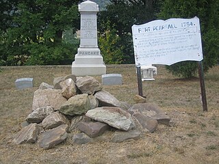
224:"Fort Pearsall was on or in view of this site."
185:Fort Pearsall Marker Romney WV 2005 09 16 01.jpg
689:https://creativecommons.org/licenses/by-sa/3.0
582:https://creativecommons.org/licenses/by-sa/3.0
369:https://creativecommons.org/licenses/by-sa/3.0
98:
695:Creative Commons Attribution-Share Alike 3.0
611:
588:Creative Commons Attribution-Share Alike 3.0
504:
375:Creative Commons Attribution-Share Alike 3.0
291:
8:
655:– to copy, distribute and transmit the work
548:– to copy, distribute and transmit the work
335:– to copy, distribute and transmit the work
1113:
1005:
716:
1088:The following other wikis use this file:
1413:
1402:
1392:
1384:
1376:
1368:
1360:
1352:
1344:
1336:
1326:
1318:
1308:
1298:
1290:
1280:
1272:
1262:
1254:
1233:
1225:
1214:
1206:
1198:
1190:
1182:
1174:
1163:
1155:
1145:
1135:
1125:
1065:
978:
962:
944:
928:
907:
891:
873:
857:
839:
823:
803:
787:
767:
751:
734:
731:
712:
705:
139:
160:View this and other nearby images on:
1115:
1063:The following 3 pages use this file:
7:
634:Attribution-Share Alike 3.0 Unported
527:Attribution-Share Alike 3.0 Unported
314:Attribution-Share Alike 3.0 Unported
994:
622:
617:
515:
510:
302:
297:
1106:
725:
719:
608:
501:
401:
288:
189:
130:
76:
724:
1157:Date and time of data generation
1096:Cimetière de l'Indian Mound
860:coordinates of the point of view
710:
666:Under the following conditions:
629:This file is licensed under the
621:
616:
610:
559:Under the following conditions:
522:This file is licensed under the
514:
509:
503:
346:Under the following conditions:
309:This file is licensed under the
301:
296:
290:
166:
152:
97:
31:
21:
707:
402:
190:
14:
875:39°20'35.372"N, 78°45'59.789"W
706:
26:
1:
1315:Flash did not fire, auto mode
36:
732:Items portrayed in this file
1354:Focal plane resolution unit
1227:Date and time of digitizing
1435:
1365:One-chip color area sensor
1320:Supported Flashpix version
1092:Usage on fr.wikipedia.org
680:same or compatible license
573:same or compatible license
360:same or compatible license
1235:Meaning of each component
1200:File change date and time
995:
457:
248:
16:
1346:Focal plane Y resolution
1338:Focal plane X resolution
1230:10:11, 16 September 2005
1203:10:11, 16 September 2005
1160:10:11, 16 September 2005
709:
646:
539:
420:along West Main Street (
326:
222:The faded marker reads:
104:This is a file from the
1378:Custom image processing
1052:
489:
467:
453:
446:
443:
394:
276:
254:
244:
237:
234:
182:
108:. Information from its
1256:Image compression mode
1031:03:33, 1 February 2009
172:39.343159; -78.766608
111:description page there
46:Size of this preview:
1292:Maximum land aperture
1184:Horizontal resolution
1131:Canon PowerShot SD200
1073:Indian Mound Cemetery
417:Indian Mound Cemetery
205:Indian Mound Cemetery
1373:Digital still camera
70:2,048 × 1,536 pixels
1295:3.625 APEX (f/3.51)
1208:Y and C positioning
1192:Vertical resolution
1117:Camera manufacturer
661:– to adapt the work
554:– to adapt the work
341:– to adapt the work
52:Other resolutions:
1415:Scene capture type
1399:Auto white balance
66:1,280 × 960 pixels
62:1,024 × 768 pixels
1422:
1421:
1142:1/250 sec (0.004)
1084:Global file usage
1056:
841:16 September 2005
790:copyright license
718:
601:
600:
498:
495:Reusing this file
448:16 September 2005
412:historical marker
388:
387:
285:
282:Reusing this file
239:16 September 2005
200:historical marker
177:
176:
126:
125:
106:Wikimedia Commons
32:Global file usage
1426:
1349:9,142.8571428571
1341:9,142.8571428571
1114:
1043:
983:
912:
754:copyright status
702:
699:
696:
693:
690:
682:as the original.
644:
642:Justin A. Wilcox
631:Creative Commons
625:
624:
620:
619:
614:
613:
595:
592:
589:
586:
583:
575:as the original.
537:
535:Justin A. Wilcox
524:Creative Commons
518:
517:
513:
512:
507:
506:
492:
472:Justin A. Wilcox
459:
449:
406:
398:
392:
382:
379:
376:
373:
370:
362:as the original.
324:
322:Justin A. Wilcox
311:Creative Commons
305:
304:
300:
299:
294:
293:
279:
259:Justin A. Wilcox
250:
240:
194:
186:
180:
173:
170:
156:
155:
149:
148:
137:
122:
101:
100:
94:
88:
86:
73:
58:640 × 480 pixels
54:320 × 240 pixels
48:800 × 600 pixels
1434:
1433:
1429:
1428:
1427:
1425:
1424:
1423:
1102:
1082:
1057:
1049:
1048:Quercus montana
1041:
997:
996:
993:
992:
991:
990:
989:
988:
987:
986:
984:
981:
971:
970:
969:
967:
956:
955:
954:
953:
952:
951:
950:
949:
947:
937:
936:
935:
933:
922:
921:
920:
919:
918:
917:
916:
915:
913:
910:
900:
899:
898:
896:
885:
884:
883:
882:
881:
880:
879:
878:
876:
866:
865:
864:
862:
851:
850:
849:
848:
847:
846:
845:
844:
842:
832:
831:
830:
828:
817:
816:
815:
814:
813:
812:
811:
810:
808:
796:
795:
794:
792:
781:
780:
779:
778:
777:
776:
775:
774:
772:
760:
759:
758:
756:
745:
744:
743:
742:
741:
739:
723:
722:
721:
704:
703:
700:
697:
694:
691:
688:
687:
645:
640:
637:
626:
607:
602:
597:
596:
593:
590:
587:
584:
581:
580:
538:
533:
530:
519:
437:
396:
389:
384:
383:
380:
377:
374:
371:
368:
367:
325:
320:
317:
306:
230:
184:
171:
144:
143:
140:Camera location
135:
128:
127:
116:
115:
114:is shown below.
90:
84:
82:
75:
74:
51:
12:
11:
5:
1432:
1430:
1420:
1419:
1416:
1412:
1411:
1408:
1401:
1400:
1397:
1391:
1390:
1387:
1383:
1382:
1381:Normal process
1379:
1375:
1374:
1371:
1367:
1366:
1363:
1362:Sensing method
1359:
1358:
1355:
1351:
1350:
1347:
1343:
1342:
1339:
1335:
1334:
1331:
1325:
1324:
1321:
1317:
1316:
1313:
1307:
1306:
1303:
1297:
1296:
1293:
1289:
1288:
1285:
1279:
1278:
1275:
1271:
1270:
1267:
1261:
1260:
1257:
1253:
1252:
1251:
1250:
1249:does not exist
1247:
1244:
1241:
1236:
1232:
1231:
1228:
1224:
1223:
1220:
1213:
1212:
1209:
1205:
1204:
1201:
1197:
1196:
1193:
1189:
1188:
1185:
1181:
1180:
1177:
1173:
1172:
1169:
1162:
1161:
1158:
1154:
1153:
1150:
1144:
1143:
1140:
1134:
1133:
1128:
1124:
1123:
1118:
1105:
1101:
1100:
1099:
1098:
1086:
1085:
1081:
1080:
1075:
1070:
1061:
1060:
1055:
1054:
1051:
1047:
1044:
1040:2,048 × 1,536
1038:
1033:
1028:
1024:
1023:
1020:
1017:
1014:
1011:
1008:
1001:
1000:
985:
979:
977:
976:
975:
974:
973:
972:
968:
963:
961:
960:
959:
958:
957:
948:
945:
943:
942:
941:
940:
939:
938:
934:
929:
927:
926:
925:
924:
923:
914:
908:
906:
905:
904:
903:
902:
901:
897:
892:
890:
889:
888:
887:
886:
877:
874:
872:
871:
870:
869:
868:
867:
863:
858:
856:
855:
854:
853:
843:
840:
838:
837:
836:
835:
834:
833:
829:
824:
822:
821:
820:
819:
818:
809:
804:
802:
801:
800:
799:
798:
797:
793:
788:
786:
785:
784:
783:
782:
773:
768:
766:
765:
764:
763:
762:
761:
757:
752:
750:
749:
748:
747:
746:
740:
735:
733:
730:
729:
728:
727:
726:
715:
714:
711:
708:
686:
685:
684:
683:
673:
664:
663:
662:
656:
649:You are free:
638:
628:
627:
609:
606:
603:
599:
598:
579:
578:
577:
576:
566:
557:
556:
555:
549:
542:You are free:
531:
521:
520:
502:
499:
487:
486:
469:
465:
464:
455:
451:
450:
445:
441:
440:
399:
390:
386:
385:
366:
365:
364:
363:
353:
344:
343:
342:
336:
329:You are free:
318:
308:
307:
289:
286:
274:
273:
256:
252:
251:
246:
242:
241:
236:
232:
231:
187:
178:
175:
174:
164:
158:
141:
134:
131:
129:
124:
123:
102:
92:
91:
45:
41:
40:
39:
34:
29:
24:
19:
13:
10:
9:
6:
4:
3:
2:
1431:
1417:
1414:
1409:
1406:
1403:
1398:
1396:
1395:White balance
1393:
1389:Auto exposure
1388:
1386:Exposure mode
1385:
1380:
1377:
1372:
1369:
1364:
1361:
1356:
1353:
1348:
1345:
1340:
1337:
1332:
1330:
1327:
1322:
1319:
1314:
1312:
1309:
1304:
1302:
1301:Metering mode
1299:
1294:
1291:
1286:
1284:
1283:Exposure bias
1281:
1276:
1274:APEX aperture
1273:
1268:
1266:
1265:Shutter speed
1263:
1258:
1255:
1248:
1245:
1242:
1239:
1238:
1237:
1234:
1229:
1226:
1221:
1218:
1215:
1210:
1207:
1202:
1199:
1194:
1191:
1186:
1183:
1178:
1175:
1170:
1168:
1164:
1159:
1156:
1151:
1149:
1146:
1141:
1139:
1138:Exposure time
1136:
1132:
1129:
1126:
1122:
1119:
1116:
1112:
1109:
1103:
1097:
1094:
1093:
1091:
1090:
1089:
1083:
1079:
1076:
1074:
1071:
1069:
1068:Fort Pearsall
1066:
1064:
1058:
1050:
1045:
1039:
1037:
1034:
1032:
1029:
1026:
1025:
1021:
1018:
1015:
1012:
1009:
1007:
1006:
1004:
998:
966:
932:
895:
894:exposure time
861:
827:
807:
791:
771:
755:
738:
692:CC BY-SA 3.0
681:
677:
674:
671:
668:
667:
665:
660:
657:
654:
651:
650:
648:
647:
643:
639:Attribution:
635:
632:
615:
604:
585:CC BY-SA 3.0
574:
570:
567:
564:
561:
560:
558:
553:
550:
547:
544:
543:
541:
540:
536:
532:Attribution:
528:
525:
508:
500:
496:
491:
488:
485:
484:United States
481:
480:West Virginia
477:
473:
470:
466:
463:
456:
452:
442:
438:
435:
434:United States
431:
430:West Virginia
427:
423:
422:U.S. Route 50
419:
418:
413:
411:
410:Fort Pearsall
405:
400:
393:
372:CC BY-SA 3.0
361:
357:
354:
351:
348:
347:
345:
340:
337:
334:
331:
330:
328:
327:
323:
319:Attribution:
315:
312:
295:
287:
283:
278:
275:
272:
271:United States
268:
267:West Virginia
264:
260:
257:
253:
247:
243:
233:
228:
225:
221:
219:
218:United States
215:
214:West Virginia
211:
207:
206:
201:
199:
198:Fort Pearsall
193:
188:
181:
169:
165:
163:
162:OpenStreetMap
159:
157:
147:
142:
138:
132:
120:
113:
112:
107:
103:
96:
95:
89:
80:
79:Original file
71:
67:
63:
59:
55:
49:
44:
38:
35:
33:
30:
28:
25:
23:
20:
18:
15:
1405:Digital zoom
1167:focal length
1127:Camera model
1110:
1107:
1087:
1062:
1002:
999:File history
965:focal length
675:
669:
658:
652:
568:
562:
551:
545:
415:
407:
403:
355:
349:
338:
332:
226:
223:
203:
195:
191:
119:You can help
109:
77:
22:File history
1370:File source
1329:Color space
1176:Orientation
770:copyrighted
676:share alike
670:attribution
569:share alike
563:attribution
395:Description
356:share alike
350:attribution
183:Description
1059:File usage
1016:Dimensions
982:millimetre
490:Permission
277:Permission
85:image/jpeg
27:File usage
1042:(1.06 MB)
1013:Thumbnail
1010:Date/Time
826:inception
605:Licensing
404:English:
192:English:
1418:Standard
1211:Centered
1171:8.462 mm
1148:F-number
1104:Metadata
931:f-number
713:Captions
659:to remix
653:to share
636:license.
552:to remix
546:to share
529:license.
458:Own work
439:IMG_0629
408:The old
339:to remix
333:to share
316:license.
249:Own work
196:The old
37:Metadata
1305:Pattern
1277:5.65625
1269:7.96875
1219:version
1195:180 dpi
1187:180 dpi
1027:current
1022:Comment
737:depicts
717:English
133:Summary
81:
1357:inches
1179:Normal
980:8.462
911:second
909:0.004
476:Romney
468:Author
462:Flickr
454:Source
426:Romney
263:Romney
255:Author
245:Source
210:Romney
150:
1407:ratio
1311:Flash
1165:Lens
1152:f/7.1
1121:Canon
474:from
424:) in
1333:sRGB
1217:Exif
1019:User
701:true
698:true
594:true
591:true
444:Date
381:true
378:true
235:Date
17:File
1222:2.2
946:7.1
414:in
208:in
202:in
1246:Cr
1243:Cb
482:,
478:,
460:/
432:,
428:,
269:,
265:,
261:,
216:,
212:,
68:|
64:|
60:|
56:|
50:.
1410:1
1323:1
1287:0
1259:3
1240:Y
497:)
493:(
436:.
284:)
280:(
220:.
121:.
87:)
72:.
Text is available under the Creative Commons Attribution-ShareAlike License. Additional terms may apply.
