110:
323:
232:
246:
335:
287:
72:
590:{{Information |Description={{en|1=*Picture depicting Fort Ridgely in 1862. *Creator: Paul Waller *Photograph Collection ca. 1862 *Location no. MN2.7F p40 *Negative no. 13718 }} |Source=[http://collections.mnhs.org/visualresources/image.cfm?imageid=19964
573:
223:
349:
for US works, such as Canada, Mainland China (not Hong Kong or Macao), Germany, Mexico, and
Switzerland. The creator and year of publication are essential information and must be provided. See
43:
194:
345:
This image might not be in the public domain outside of the United States; this especially applies in the countries and areas that do not apply the
117:
239:
414:
670:
This file contains additional information, probably added from the digital camera or scanner used to create or digitize it.
518:
502:
468:
706:
434:
398:
350:
614:
83:
346:
51:
354:
673:
If the file has been modified from its original state, some details may not fully reflect the modified file.
583:
600:
The following pages on the
English Knowledge (XXG) use this file (pages on other projects are not listed):
91:
312:
311:
occurred prior to
January 1, 1929, and if not then due to lack of notice or renewal. See
299:
245:
307:. This applies to U.S. works where the copyright has expired, often because its first
126:
604:
572:
567:
78:
42:
609:
308:
229:
721:
304:
104:
184:
540:
Click on a date/time to view the file as it appeared at that time.
632:
461:
121:
231:
281:
214:
116:
This is an image of a place or building that is listed on the
66:
333:
321:
285:
224:
44° 27′ 03″ N, 94° 43′ 54″ W
647:
637:
382:
Add a one-line explanation of what this file represents
657:
143:
90:
Commons is a freely licensed media file repository.
198:
56:(572 × 480 pixels, file size: 81 KB, MIME type:
71:
8:
675:
542:
378:
261:
625:The following other wikis use this file:
719:
711:
701:
693:
685:
677:
602:
516:
500:
482:
466:
448:
432:
412:
396:
393:
374:
367:
217:
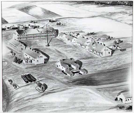
161:Picture depicting Fort Ridgely in 1862.
238:View this and other nearby images on:
322:
286:
7:
118:National Register of Historic Places
531:
668:
387:
381:
344:
295:
153:
103:
49:
386:
372:
244:
230:
199:The Minnesota Historical Society
108:
70:
31:
21:
369:
154:
46:No higher resolution available.
14:
368:
167:Photograph Collection ca. 1862
26:
1:
484:44°27'2.999"N, 94°43'54.001"W
469:coordinates of depicted place
351:Knowledge (XXG):Public domain
36:
394:Items portrayed in this file
707:Adobe Photoshop CS2 Windows
743:
654:Usage on www.wikidata.org
644:Usage on fr.wikipedia.org
629:Usage on de.wikipedia.org
615:User:Mcb133aco/New sandbox
355:Knowledge (XXG):Copyrights
297:This media file is in the
124:. Its reference number is
713:File change date and time
532:
16:
371:
347:rule of the shorter term
315:for further explanation.
122:United States of America
77:This is a file from the
589:
568:18:27, 18 February 2009
204:
190:
183:
180:
170:Location no. MN2.7F p40
146:
81:. Information from its
716:15:17, 29 January 2009
338:
327:
291:
250:44.450833; -94.731667
84:description page there
687:Horizontal resolution
337:
325:
289:
633:Samuel Dutton Hinman
503:location of creation
164:Creator: Paul Waller
695:Vertical resolution
149:FortRidgely1862.jpg
52:FortRidgely1862.jpg
339:
328:
292:
173:Negative no. 13718
730:
729:
621:Global file usage
593:
380:
366:
365:
359:
357:for more details.
280:
279:
255:
254:
212:
211:
136:
135:
99:
98:
79:Wikimedia Commons
32:Global file usage
734:
676:
585:Mnhs~commonswiki
580:
360:
343:
336:
324:
288:
282:
276:
273:
270:
267:
262:
251:
248:
234:
233:
227:
226:
215:
186:
158:
150:
144:
129:
112:
111:
105:
95:
74:
73:
67:
61:
59:
742:
741:
737:
736:
735:
733:
732:
731:
664:
619:
601:
594:
586:
578:
534:
533:
530:
529:
528:
527:
526:
525:
524:
523:
521:
519:Nicollet County
509:
508:
507:
505:
494:
493:
492:
491:
490:
489:
488:
487:
485:
475:
474:
473:
471:
460:
459:
458:
457:
456:
455:
454:
453:
451:
441:
440:
439:
437:
426:
425:
424:
423:
422:
421:
420:
419:
417:
405:
404:
403:
401:
385:
384:
383:
358:
342:
334:
317:
274:
271:
268:
265:
260:
249:
222:
221:
218:Object location
213:
176:
148:
141:
125:
109:
101:
100:
89:
88:
87:is shown below.
63:
57:
55:
48:
47:
12:
11:
5:
740:
738:
728:
727:
724:
718:
717:
714:
710:
709:
704:
700:
699:
696:
692:
691:
688:
684:
683:
680:
667:
663:
662:
661:
660:
652:
651:
650:
642:
641:
640:
635:
623:
622:
618:
617:
612:
607:
599:
598:
597:
592:
591:
588:
584:
581:
575:
570:
565:
561:
560:
557:
554:
551:
548:
545:
538:
537:
522:
517:
515:
514:
513:
512:
511:
510:
506:
501:
499:
498:
497:
496:
495:
486:
483:
481:
480:
479:
478:
477:
476:
472:
467:
465:
464:
463:
462:
452:
449:
447:
446:
445:
444:
443:
442:
438:
433:
431:
430:
429:
428:
427:
418:
413:
411:
410:
409:
408:
407:
406:
402:
397:
395:
392:
391:
390:
389:
388:
377:
376:
373:
370:
364:
363:
361:
340:
330:
329:
319:
293:
278:
277:
259:
256:
253:
252:
242:
236:
219:
210:
209:
206:
202:
201:
195:Original Image
192:
188:
187:
182:
178:
177:
175:
174:
171:
168:
165:
162:
151:
142:
140:
137:
134:
133:
113:
102:
97:
96:
75:
65:
64:
45:
41:
40:
39:
34:
29:
24:
19:
13:
10:
9:
6:
4:
3:
2:
739:
725:
723:
720:
715:
712:
708:
705:
703:Software used
702:
697:
694:
689:
686:
681:
678:
674:
671:
665:
659:
656:
655:
653:
649:
646:
645:
643:
639:
636:
634:
631:
630:
628:
627:
626:
620:
616:
613:
611:
608:
606:
605:Azayamankawin
603:
595:
587:
582:
576:
574:
571:
569:
566:
563:
562:
558:
555:
552:
549:
546:
544:
543:
541:
535:
520:
504:
470:
436:
416:
400:
362:
356:
352:
348:
341:
332:
331:
326:United States
320:
318:
316:
314:
310:
306:
305:United States
302:
301:
300:public domain
294:
290:Public domain
284:
283:
269:Public domain
266:Public domain
264:
263:
257:
247:
243:
241:
240:OpenStreetMap
237:
235:
225:
220:
216:
207:
203:
200:
196:
193:
189:
179:
172:
169:
166:
163:
160:
159:
157:
152:
145:
138:
132:
131:
128:
123:
119:
114:
107:
106:
93:
86:
85:
80:
76:
69:
68:
62:
53:
44:
38:
35:
33:
30:
28:
25:
23:
20:
18:
15:
672:
669:
648:Fort Ridgely
638:Fort Ridgely
624:
610:Fort Ridgely
539:
536:File history
415:Fort Ridgely
298:
296:
155:
115:
92:You can help
82:
50:
22:File history
722:Color space
679:Orientation
309:publication
208:Paul Waller
197:taken from
147:Description
596:File usage
577:572 × 480
553:Dimensions
58:image/jpeg
27:File usage
550:Thumbnail
547:Date/Time
435:inception
313:this page
258:Licensing
156:English:
666:Metadata
658:Q5471924
375:Captions
127:70000304
37:Metadata
698:150 dpi
690:150 dpi
579:(81 KB)
564:current
559:Comment
399:depicts
379:English
303:in the
139:Summary
120:in the
54:
682:Normal
228:
205:Author
191:Source
275:false
272:false
726:sRGB
556:User
450:1862
353:and
185:1862
181:Date
17:File
130:.
94:.
60:)
Text is available under the Creative Commons Attribution-ShareAlike License. Additional terms may apply.