43:
211:
299:
313:
217:
597:{{Information |Description={{en| Köppen–Geiger climate classification map for Afghanistan}}|date=2018-11-06|source={{cite journal | journal=Nature Scientific Data |doi=10.1038/sdata.2018.214}}|author=Beck, H.E., Zimmermann, N. E., McVicar, T. R., Vergopolan, N., Berg, A., & Wood, E. F.|permission=|other_versions=|other_fields=}}{{Cc-by-4.0}}{{Location|33.926248555|67.69949722}}
99:
580:
258:– You must give appropriate credit, provide a link to the license, and indicate if changes were made. You may do so in any reasonable manner, but not in any way that suggests the licensor endorses you or your use.
681:
290:
711:
701:
73:
69:
65:
61:
57:
53:
47:
110:
82:
598:
656:
423:
387:
306:
744:
This file contains additional information, probably added from the digital camera or scanner used to create or digitize it.
623:
601:
511:
477:
371:
443:
407:
354:
179:
747:
If the file has been modified from its original state, some details may not fully reflect the modified file.
691:
614:
The following pages on the
English Knowledge (XXG) use this file (pages on other projects are not listed):
227:
590:
224:
676:
651:
641:
579:
574:
42:
118:
196:
Beck, H.E., Zimmermann, N. E., McVicar, T. R., Vergopolan, N., Berg, A., & Wood, E. F.
312:
105:
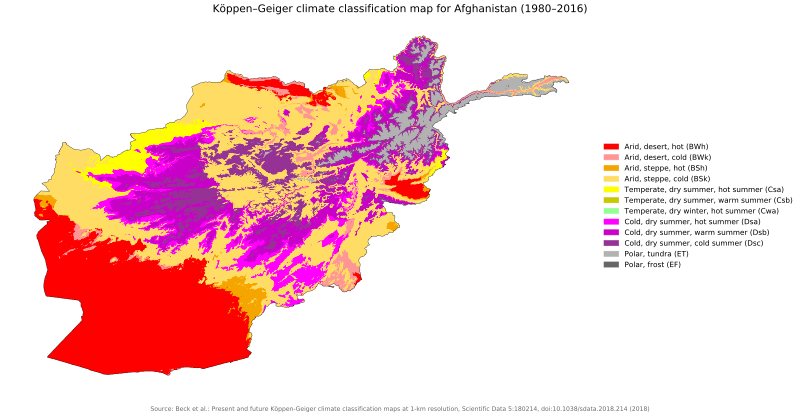
173:"Present and future Köppen-Geiger climate classification maps at 1-km resolution".
296:
618:
162:
184:
721:
470:
666:
547:
Click on a date/time to view the file as it appeared at that time.
298:
291:
33° 55′ 34.5″ N, 67° 41′ 58.19″ E
281:
93:
87:(SVG file, nominally 1,643 × 850 pixels, file size: 1.04 MB)
731:
153:
Köppen–Geiger climate classification map for
Afghanistan
338:
Add a one-line explanation of what this file represents
137:
117:
Commons is a freely licensed media file repository.
599:Category:Köppen-Geiger Climate Classification Maps
424:Creative Commons Attribution 4.0 International
98:
210:
8:
265:https://creativecommons.org/licenses/by/4.0
241:– to copy, distribute and transmit the work
46:Size of this PNG preview of this SVG file:
749:
549:
334:
634:The following other wikis use this file:
759:
751:
616:
525:
509:
491:
475:
457:
441:
421:
405:
385:
369:
352:
349:
330:
323:
284:
305:View this and other nearby images on:
7:
602:Category:present climate (1980–2016)
538:
216:
178:
742:
493:33°55'34.49482"N, 67°41'58.18999"E
343:
337:
232:
207:
147:
130:
80:
342:
271:Creative Commons Attribution 4.0
143:Koppen-Geiger Map AFG present.svg
478:coordinates of the point of view
328:
311:
297:
252:Under the following conditions:
223:This file is licensed under the
215:
209:
97:
31:
21:
325:
148:
14:
324:
26:
1:
722:Afg'oniston geografiyasi
624:Climate change in Afghanistan
228:Attribution 4.0 International
36:
350:Items portrayed in this file
698:Usage on mnw.wikipedia.org
682:Աֆղանստանի աշխարհագրություն
781:
728:Usage on vi.wikipedia.org
718:Usage on uz.wikipedia.org
708:Usage on uk.wikipedia.org
688:Usage on ja.wikipedia.org
673:Usage on hy.wikipedia.org
663:Usage on fi.wikipedia.org
648:Usage on fa.wikipedia.org
638:Usage on ar.wikipedia.org
539:
16:
327:
104:This is a file from the
596:
575:03:01, 26 November 2018
192:
168:
161:
158:
140:
108:. Information from its
667:Afganistanin maantiede
317:33.926249; 67.699497
185:10.1038/sdata.2018.214
175:Nature Scientific Data
111:description page there
712:Географія Афганістану
70:2,560 × 1,324 pixels
247:– to adapt the work
52:Other resolutions:
74:1,643 × 850 pixels
66:1,280 × 662 pixels
62:1,024 × 530 pixels
768:
767:
630:Global file usage
607:
408:copyright license
336:
322:
321:
200:
199:
126:
125:
106:Wikimedia Commons
32:Global file usage
772:
750:
587:
372:copyright status
318:
315:
301:
300:
294:
293:
282:
278:
275:
272:
269:
266:
225:Creative Commons
219:
218:
213:
212:
188:
182:
164:
152:
144:
138:
122:
101:
100:
94:
88:
77:
58:640 × 331 pixels
54:320 × 166 pixels
48:800 × 414 pixels
780:
779:
775:
774:
773:
771:
770:
769:
738:
657:اقلیم افغانستان
628:
615:
608:
593:
585:
541:
540:
537:
536:
535:
534:
533:
532:
531:
530:
528:
518:
517:
516:
514:
503:
502:
501:
500:
499:
498:
497:
496:
494:
484:
483:
482:
480:
469:
468:
467:
466:
465:
464:
463:
462:
460:
459:6 November 2018
450:
449:
448:
446:
435:
434:
433:
432:
431:
430:
429:
428:
426:
414:
413:
412:
410:
399:
398:
397:
396:
395:
394:
393:
392:
390:
378:
377:
376:
374:
363:
362:
361:
360:
359:
357:
341:
340:
339:
316:
289:
288:
285:Camera location
280:
279:
276:
273:
270:
267:
264:
263:
231:
220:
206:
201:
172:
163:6 November 2018
154:
142:
135:
128:
127:
116:
115:
114:is shown below.
90:
86:
79:
78:
51:
12:
11:
5:
778:
776:
766:
765:
762:
758:
757:
754:
741:
737:
736:
735:
734:
726:
725:
724:
716:
715:
714:
706:
705:
704:
696:
695:
694:
686:
685:
684:
679:
671:
670:
669:
661:
660:
659:
654:
646:
645:
644:
632:
631:
627:
626:
621:
613:
612:
611:
606:
605:
595:
591:
588:
582:
577:
572:
568:
567:
564:
561:
558:
555:
552:
545:
544:
529:
526:
524:
523:
522:
521:
520:
519:
515:
510:
508:
507:
506:
505:
504:
495:
492:
490:
489:
488:
487:
486:
485:
481:
476:
474:
473:
472:
471:
461:
458:
456:
455:
454:
453:
452:
451:
447:
442:
440:
439:
438:
437:
436:
427:
422:
420:
419:
418:
417:
416:
415:
411:
406:
404:
403:
402:
401:
400:
391:
386:
384:
383:
382:
381:
380:
379:
375:
370:
368:
367:
366:
365:
364:
358:
353:
351:
348:
347:
346:
345:
344:
333:
332:
329:
326:
320:
319:
309:
303:
286:
262:
261:
260:
259:
250:
249:
248:
242:
235:You are free:
222:
221:
208:
205:
202:
198:
197:
194:
190:
189:
170:
166:
165:
160:
156:
155:
145:
136:
134:
131:
129:
124:
123:
102:
92:
91:
45:
41:
40:
39:
34:
29:
24:
19:
13:
10:
9:
6:
4:
3:
2:
777:
763:
760:
755:
752:
748:
745:
739:
733:
730:
729:
727:
723:
720:
719:
717:
713:
710:
709:
707:
703:
702:အဖဂါန္နိသတာန်
700:
699:
697:
693:
690:
689:
687:
683:
680:
678:
675:
674:
672:
668:
665:
664:
662:
658:
655:
653:
650:
649:
647:
643:
640:
639:
637:
636:
635:
629:
625:
622:
620:
617:
609:
603:
600:
594:
589:
583:
581:
578:
576:
573:
570:
569:
565:
562:
559:
556:
553:
551:
550:
548:
542:
527:image/svg+xml
513:
479:
445:
425:
409:
389:
373:
356:
314:
310:
308:
307:OpenStreetMap
304:
302:
292:
287:
283:
257:
254:
253:
251:
246:
243:
240:
237:
236:
234:
233:
229:
226:
214:
203:
195:
191:
186:
181:
176:
171:
167:
157:
151:
146:
139:
132:
120:
113:
112:
107:
103:
96:
95:
89:
84:
83:Original file
75:
71:
67:
63:
59:
55:
49:
44:
38:
35:
33:
30:
28:
25:
23:
20:
18:
15:
746:
743:
633:
584:1,643 × 850
546:
543:File history
255:
244:
238:
174:
149:
119:You can help
109:
81:
22:File history
732:Afghanistan
619:Afghanistan
592:NVergopolan
388:copyrighted
256:attribution
141:Description
610:File usage
560:Dimensions
512:media type
268:CC BY 4.0
27:File usage
677:Աֆղանստան
652:افغانستان
642:أفغانستان
586:(1.04 MB)
557:Thumbnail
554:Date/Time
444:inception
204:Licensing
150:English:
740:Metadata
331:Captions
245:to remix
239:to share
230:license.
37:Metadata
692:アフガニスタン
571:current
566:Comment
355:depicts
335:English
133:Summary
85:
761:Height
756:1314pt
295:
193:Author
169:Source
764:680pt
753:Width
563:User
277:true
274:true
159:Date
17:File
604:...
180:DOI
177:.
72:|
68:|
64:|
60:|
56:|
50:.
187:.
183::
121:.
76:.
Text is available under the Creative Commons Attribution-ShareAlike License. Additional terms may apply.
