38:
345:
333:
321:
629:
720:
635:
365:
640:
94:
1003:
973:
681:– You must give appropriate credit, provide a link to the license, and indicate if changes were made. You may do so in any reasonable manner, but not in any way that suggests the licensor endorses you or your use.
278:
737:
60:
56:
52:
48:
42:
379:
105:
73:
1185:
735:; with no Invariant Sections, no Front-Cover Texts, and no Back-Cover Texts. A copy of the license is included in the section entitled
231:
727:
884:
867:
831:
1002:
997:
688:
904:
815:
732:
851:
798:
372:
184:
650:
344:
604:
1155:
1115:
1038:
The following pages on the
English Knowledge (XXG) use this file (pages on other projects are not listed):
332:
277:
687:– If you remix, transform, or build upon the material, you must distribute your contributions under the
320:
647:
972:
967:
64:
37:
1135:
113:
217:
714:
725:
Permission is granted to copy, distribute and/or modify this document under the terms of the
1013:
983:
221:
364:
1028:, englische Version}} Carte topographique détaillée en anglais de l'[[:fr:Ilha Gran
225:
622:
I, the copyright holder of this work, hereby publish it under the following licenses:
248:
100:
414:
301:
150:
1042:
1021:
1085:
1025:
235:
196:
173:
161:
1080:
522:
486:
594:
585:
576:
567:
558:
549:
540:
531:
513:
504:
495:
477:
468:
459:
450:
441:
432:
423:
405:
396:
387:
1125:
1020:{{Information |Description={{en|1=Detailed topographic map in Englisch of
132:
940:
Click on a date/time to view the file as it appeared at that time.
212:
1145:
88:
218:
http://www.jornadasub.com.br/Figuras/mapa%20Ilha%20Grande.jpg
1070:
415:
222:
http://www.angra-dos-reis.com/mapas/mapa_ilha_grande2.jpg
1175:
1165:
1105:
1095:
1060:
782:
Add a one-line explanation of what this file represents
78:(2,052 × 1,194 pixels, file size: 1.52 MB, MIME type:
885:
Creative
Commons Attribution-ShareAlike 3.0 Unported
868:
731:, Version 1.2 or any later version published by the
359:
226:
http://ilhagrande.org/vr/im/127/mapa-ilha-grande.jpg
112:
Commons is a freely licensed media file repository.
523:
487:
595:
586:
577:
568:
559:
550:
541:
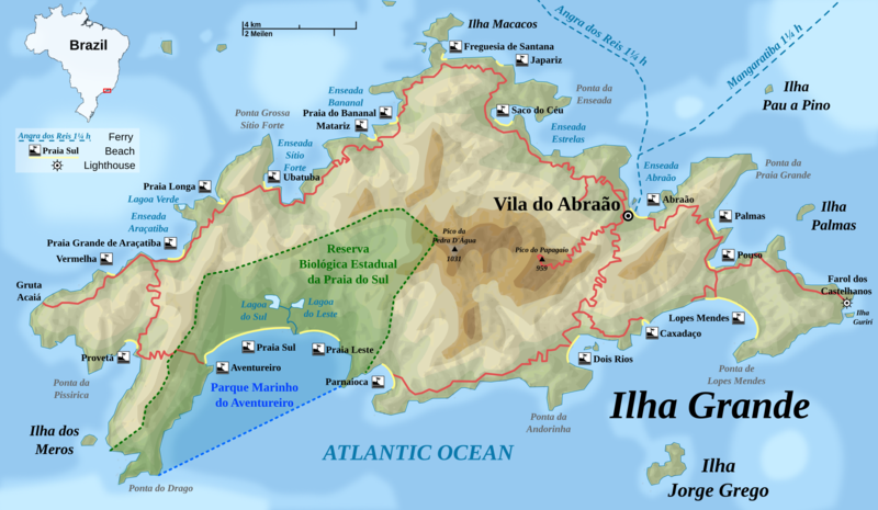
532:
514:
505:
496:
478:
469:
460:
451:
442:
433:
424:
406:
397:
388:
371:This map has been made or improved in the German
304:View the georeferenced map in the Wikimaps Warper
698:https://creativecommons.org/licenses/by-sa/3.0
172:Carte topographique détaillée en anglais de l'
93:
704:Creative Commons Attribution-Share Alike 3.0
628:
8:
664:– to copy, distribute and transmit the work
942:
778:
763:You may select the license of your choice.
603:
1053:The following other wikis use this file:
232:File:Japanese Map symbol (Lighthouse).svg
183:Mapa topográfico detalhado em inglês de
1040:
918:
902:
882:
865:
849:
829:
813:
796:
793:
774:
767:
316:
149:Detailed topographic map in English of
7:
743:http://www.gnu.org/copyleft/fdl.html
651:Attribution-Share Alike 3.0 Unported
931:
639:
634:
1024:}} {{de|1=Topografische Karte der
787:
781:
762:
625:
621:
370:
178:
177:
166:
154:
143:
138:Ilha Grande topographic map-EN.png
125:
71:
786:
772:
719:
718:
675:Under the following conditions:
646:This file is licensed under the
638:
633:
627:
363:
343:
331:
319:
276:
92:
31:
21:
769:
144:
14:
768:
749:GNU Free Documentation License
738:GNU Free Documentation License
728:GNU Free Documentation License
167:
155:
26:
1:
1126:Isola Grande (Rio de Janeiro)
1086:Anexo:Islas del Atlántico Sur
302:
213:http://www.maps-for-free.com/
207:Own work by uploader, using:
1081:Isla Grande (Río de Janeiro)
794:Items portrayed in this file
1067:Usage on en.wikivoyage.org
1204:
1182:Usage on zh.wikipedia.org
1172:Usage on vi.wikipedia.org
1162:Usage on tr.wikipedia.org
1152:Usage on ru.wikipedia.org
1142:Usage on lt.wikipedia.org
1132:Usage on ko.wikipedia.org
1122:Usage on it.wikipedia.org
1112:Usage on hy.wikipedia.org
1102:Usage on hr.wikipedia.org
1092:Usage on fi.wikipedia.org
1077:Usage on es.wikipedia.org
1057:Usage on da.wikipedia.org
689:same or compatible license
264:
932:
287:
267:
255:
16:
771:
733:Free Software Foundation
655:
160:Topografische Karte der
99:This is a file from the
1019:
989:
312:
296:
260:
243:
230:Lighthouse map symbol:
202:
192:
135:
103:. Information from its
256: Geotemporal data
106:description page there
41:Size of this preview:
382:to improve as well.
65:2,052 × 1,194 pixels
670:– to adapt the work
164:, englische Version
47:Other resolutions:
998:16:30, 4 July 2009
968:08:12, 5 July 2009
416:Deutsch (Sie-Form)
350:Portuguese-Version
61:1,280 × 745 pixels
57:1,024 × 596 pixels
1049:Global file usage
1031:
990:a few corrections
852:copyright license
780:
760:
759:
613:
612:
607:
357:
356:
292:
291:
121:
120:
101:Wikimedia Commons
32:Global file usage
1195:
1010:
980:
816:copyright status
756:
753:
750:
747:
744:
722:
721:
715:
711:
708:
705:
702:
699:
691:as the original.
648:Creative Commons
642:
641:
637:
636:
631:
630:
608:
367:
360:
347:
335:
323:
308:
306:
305:
280:
265:
198:
182:
171:
169:Français :
159:
148:
139:
133:
117:
96:
95:
89:
83:
81:
68:
53:640 × 372 pixels
49:320 × 186 pixels
43:800 × 465 pixels
1203:
1202:
1198:
1197:
1196:
1194:
1193:
1192:
1047:
1039:
1032:
1016:
1008:
986:
978:
934:
933:
930:
929:
928:
927:
926:
925:
924:
923:
921:
911:
910:
909:
907:
896:
895:
894:
893:
892:
891:
890:
889:
887:
876:
875:
874:
873:
872:
870:
858:
857:
856:
854:
843:
842:
841:
840:
839:
838:
837:
836:
834:
822:
821:
820:
818:
807:
806:
805:
804:
803:
801:
785:
784:
783:
766:
765:
764:
754:
751:
748:
745:
742:
713:
712:
709:
706:
703:
700:
697:
696:
654:
643:
624:
623:
618:
609:
597:
588:
579:
570:
561:
552:
543:
534:
525:
516:
507:
498:
489:
480:
471:
462:
453:
444:
435:
426:
417:
408:
399:
390:
386:
383:
373:Kartenwerkstatt
358:
351:
348:
339:
336:
327:
324:
303:
300:
288:S: 23.2381147°S
283:E: 44.0789522°W
273:W: 44.3923427°W
268:N: 23.0693774°S
251:
188:
187:
176:
165:
153:
137:
130:
123:
122:
111:
110:
109:is shown below.
85:
79:
77:
70:
69:
46:
12:
11:
5:
1201:
1199:
1191:
1190:
1189:
1188:
1180:
1179:
1178:
1170:
1169:
1168:
1160:
1159:
1158:
1150:
1149:
1148:
1140:
1139:
1138:
1130:
1129:
1128:
1120:
1119:
1118:
1110:
1109:
1108:
1100:
1099:
1098:
1090:
1089:
1088:
1083:
1075:
1074:
1073:
1065:
1064:
1063:
1051:
1050:
1046:
1045:
1037:
1036:
1035:
1030:
1029:
1018:
1014:
1011:
1007:2,052 × 1,194
1005:
1000:
995:
992:
991:
988:
984:
981:
977:2,052 × 1,194
975:
970:
965:
961:
960:
957:
954:
951:
948:
945:
938:
937:
922:
919:
917:
916:
915:
914:
913:
912:
908:
903:
901:
900:
899:
898:
897:
888:
883:
881:
880:
879:
878:
877:
871:
866:
864:
863:
862:
861:
860:
859:
855:
850:
848:
847:
846:
845:
844:
835:
830:
828:
827:
826:
825:
824:
823:
819:
814:
812:
811:
810:
809:
808:
802:
797:
795:
792:
791:
790:
789:
788:
777:
776:
773:
770:
761:
758:
757:
723:
695:
694:
693:
692:
682:
673:
672:
671:
665:
658:You are free:
645:
644:
626:
620:
619:
617:
614:
611:
610:
385:
368:
355:
354:
353:
352:
349:
342:
340:
338:French-Version
337:
330:
328:
326:German-Version
325:
318:
314:
313:Other versions
310:
309:
298:
297:Georeferencing
294:
293:
290:
289:
285:
284:
281:
274:
270:
269:
262:
258:
257:
253:
252:
247:
245:
241:
240:
239:
238:
228:
215:
204:
200:
199:
194:
190:
189:
142:
140:
131:
129:
126:
124:
119:
118:
97:
87:
86:
40:
36:
35:
34:
29:
24:
19:
13:
10:
9:
6:
4:
3:
2:
1200:
1187:
1186:格蘭德島 (里約熱內盧州)
1184:
1183:
1181:
1177:
1174:
1173:
1171:
1167:
1164:
1163:
1161:
1157:
1154:
1153:
1151:
1147:
1146:Grandė (sala)
1144:
1143:
1141:
1137:
1134:
1133:
1131:
1127:
1124:
1123:
1121:
1117:
1114:
1113:
1111:
1107:
1104:
1103:
1101:
1097:
1094:
1093:
1091:
1087:
1084:
1082:
1079:
1078:
1076:
1072:
1069:
1068:
1066:
1062:
1059:
1058:
1056:
1055:
1054:
1048:
1044:
1041:
1033:
1027:
1023:
1017:
1012:
1006:
1004:
1001:
999:
996:
994:
993:
987:
982:
976:
974:
971:
969:
966:
963:
962:
958:
955:
952:
949:
946:
944:
943:
941:
935:
906:
886:
869:
853:
833:
817:
800:
740:
739:
734:
730:
729:
724:
717:
716:
701:CC BY-SA 3.0
690:
686:
683:
680:
677:
676:
674:
669:
666:
663:
660:
659:
657:
656:
652:
649:
632:
615:
606:
602:
598:
593:
589:
584:
580:
575:
571:
566:
562:
557:
553:
548:
544:
539:
535:
530:
526:
521:
517:
512:
508:
503:
499:
494:
490:
485:
481:
476:
472:
467:
463:
458:
454:
449:
445:
440:
436:
431:
427:
422:
418:
413:
409:
404:
400:
395:
391:
384:
381:
377:
374:
369:
366:
362:
361:
346:
341:
334:
329:
322:
317:
315:
311:
307:
299:
295:
286:
282:
279:
275:
272:
271:
266:
263:
259:
254:
250:
246:
242:
237:
233:
229:
227:
223:
219:
216:
214:
210:
209:
208:
205:
201:
195:
191:
186:
181:
175:
170:
163:
158:
152:
147:
141:
134:
127:
115:
108:
107:
102:
98:
91:
90:
84:
75:
74:Original file
66:
62:
58:
54:
50:
44:
39:
33:
30:
28:
25:
23:
20:
18:
15:
1052:
939:
936:File history
736:
726:
684:
678:
667:
661:
600:
591:
582:
573:
564:
555:
546:
537:
528:
519:
510:
501:
492:
488:Plattdüütsch
483:
474:
465:
456:
447:
438:
429:
420:
411:
402:
393:
389:azərbaycanca
380:propose maps
375:
261:Bounding box
206:
179:
168:
156:
145:
114:You can help
104:
72:
22:File history
1176:Ilha Grande
1166:Ilha Grande
1156:Илья-Гранди
1116:Իլյա Գրանդի
1106:Ilha Grande
1096:Ilha Grande
1071:Ilha Grande
1061:Ilha Grande
1043:Ilha Grande
1026:Ilha Grande
1022:Ilha Grande
1015:Rosso Robot
985:Rosso Robot
832:copyrighted
685:share alike
679:attribution
533:slovenščina
249:Rosso Robot
197:4 July 2009
185:Ilha Grande
180:Português:
174:Ilha Grande
162:Ilha Grande
151:Ilha Grande
136:Description
1034:File usage
953:Dimensions
905:media type
551:македонски
479:Nederlands
378:. You can
27:File usage
1009:(1.52 MB)
979:(1.52 MB)
950:Thumbnail
947:Date/Time
920:image/png
616:Licensing
524:sicilianu
506:português
376:(Map Lab)
157:Deutsch:
146:English:
80:image/png
775:Captions
668:to remix
662:to share
653:license.
461:latviešu
452:italiano
443:français
236:Monaneko
211:Relief:
964:current
959:Comment
799:depicts
779:English
578:հայերեն
569:ქართული
560:русский
434:español
425:English
407:Deutsch
398:čeština
244:Creator
128:Summary
76:
1136:일랴그란지섬
599:
590:
581:
572:
563:
554:
545:
536:
527:
518:
515:română
509:
500:
497:polski
491:
482:
473:
470:magyar
464:
455:
446:
437:
428:
419:
410:
401:
392:
203:Source
587:বাংলা
542:suomi
956:User
755:true
752:true
746:GFDL
710:true
707:true
224:and
193:Date
17:File
605:+/−
596:ไทย
234:by
220:,
63:|
59:|
55:|
51:|
45:.
741:.
601:∙
592:∙
583:∙
574:∙
565:∙
556:∙
547:∙
538:∙
529:∙
520:∙
511:∙
502:∙
493:∙
484:∙
475:∙
466:∙
457:∙
448:∙
439:∙
430:∙
421:∙
412:∙
403:∙
394:∙
116:.
82:)
67:.
Text is available under the Creative Commons Attribution-ShareAlike License. Additional terms may apply.

.svg)

