125:
255:
317:
331:
267:
219:
87:
43:
559:
513:
308:
281:
for US works, such as Canada, Mainland China (not Hong Kong or Macao), Germany, Mexico, and
Switzerland. The creator and year of publication are essential information and must be provided. See
549:
554:
657:
277:
This image might not be in the public domain outside of the United States; this especially applies in the countries and areas that do not apply the
132:
324:
388:
720:
This file contains additional information, probably added from the digital camera or scanner used to create or digitize it.
458:
662:
442:
408:
523:
372:
282:
569:
278:
286:
723:
If the file has been modified from its original state, some details may not fully reflect the modified file.
574:
540:
The following pages on the
English Knowledge (XXG) use this file (pages on other projects are not listed):
165:
53:
47:
106:
98:
66:
622:
244:
185:
564:
243:
occurred prior to
January 1, 1929, and if not then due to lack of notice or renewal. See
330:
231:
179:
239:. This applies to U.S. works where the copyright has expired, often because its first
141:
544:
93:
314:
240:
236:
119:
512:
507:
57:
42:
642:
560:
National
Register of Historic Places listings in Navajo County, Arizona
480:
Click on a date/time to view the file as it appeared at that time.
401:
136:
316:
299:
213:
131:
This is an image of a place or building that is listed on the
81:
632:
265:
253:
217:
309:
35° 52′ 37″ N, 110° 38′ 17″ W
687:
602:
356:
Add a one-line explanation of what this file represents
707:
612:
105:
Commons is a freely licensed media file repository.
697:
682:
672:
647:
592:
623:Liste der National Historic Landmarks in Arizona
71:(530 × 640 pixels, file size: 39 KB, MIME type:
550:List of Ancestral Puebloan dwellings in Arizona
530:Oraibi Pueblo, circa 1899 Original: License:
555:List of National Historic Landmarks in Arizona
86:
8:
725:
482:
352:
193:
585:The following other wikis use this file:
727:
542:
456:
440:
422:
406:
386:
370:
367:
348:
341:
302:
323:View this and other nearby images on:
254:
218:
7:
133:National Register of Historic Places
471:
718:
361:
355:
276:
227:
157:
118:
64:
360:
346:
329:
315:
123:
85:
31:
21:
424:35°52'36.998"N, 110°38'17.002"W
343:
158:
14:
342:
26:
1:
409:coordinates of depicted place
283:Knowledge (XXG):Public domain
36:
368:Items portrayed in this file
609:Usage on dag.wikipedia.org
525:Mr. Know-It-All~commonswiki
749:
704:Usage on www.wikidata.org
694:Usage on sh.wikipedia.org
679:Usage on it.wikipedia.org
669:Usage on hr.wikipedia.org
654:Usage on he.wikipedia.org
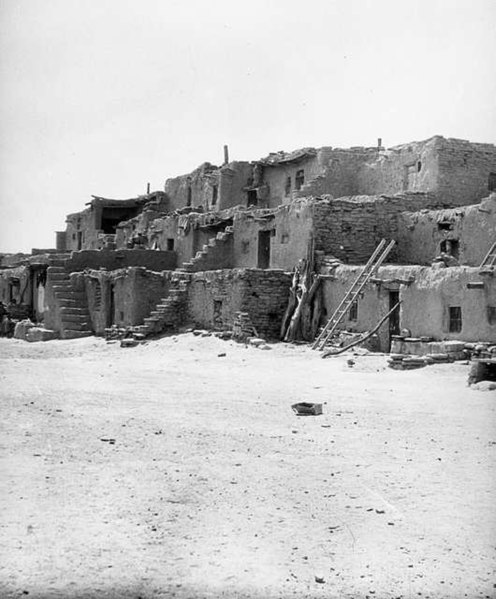
643:National Historic Landmark
639:Usage on fr.wikipedia.org
629:Usage on es.wikipedia.org
619:Usage on de.wikipedia.org
599:Usage on cs.wikipedia.org
589:Usage on ca.wikipedia.org
570:Southwestern United States
287:Knowledge (XXG):Copyrights
229:This media file is in the
139:. Its reference number is
472:
16:
345:
279:rule of the shorter term
247:for further explanation.
137:United States of America
92:This is a file from the
529:
96:. Information from its
575:User:Aadkinson/sandbox
508:06:03, 3 February 2006
335:35.876944; -110.638056
270:
259:
223:
99:description page there
46:Size of this preview:
658:דרום-מערב ארצות הברית
269:
257:
221:
166:Hopi pueblo of Oraibi
443:location of creation
663:ג'ייקוב המבלין
52:Other resolutions:
271:
260:
224:
736:
735:
581:Global file usage
533:
354:
340:
339:
298:
297:
291:
289:for more details.
212:
211:
151:
150:
114:
113:
94:Wikimedia Commons
32:Global file usage
740:
726:
633:Oraibi (Arizona)
520:
336:
333:
319:
318:
312:
311:
300:
292:
275:
268:
256:
220:
214:
208:
205:
202:
199:
194:
162:
144:
127:
126:
120:
110:
89:
88:
82:
76:
74:
61:
58:530 × 640 pixels
54:199 × 240 pixels
48:496 × 599 pixels
748:
747:
743:
742:
741:
739:
738:
737:
714:
579:
565:Oraibi, Arizona
541:
534:
526:
518:
474:
473:
470:
469:
468:
467:
466:
465:
464:
463:
461:
449:
448:
447:
445:
434:
433:
432:
431:
430:
429:
428:
427:
425:
415:
414:
413:
411:
400:
399:
398:
397:
396:
395:
394:
393:
391:
379:
378:
377:
375:
359:
358:
357:
334:
307:
306:
303:Object location
290:
274:
266:
249:
206:
203:
200:
197:
192:
170:
156:
140:
124:
116:
115:
104:
103:
102:is shown below.
78:
72:
70:
63:
62:
51:
12:
11:
5:
746:
744:
734:
733:
730:
717:
713:
712:
711:
710:
702:
701:
700:
692:
691:
690:
685:
677:
676:
675:
667:
666:
665:
660:
652:
651:
650:
645:
637:
636:
635:
627:
626:
625:
617:
616:
615:
607:
606:
605:
597:
596:
595:
583:
582:
578:
577:
572:
567:
562:
557:
552:
547:
539:
538:
537:
532:
531:
528:
524:
521:
515:
510:
505:
501:
500:
497:
494:
491:
488:
485:
478:
477:
462:
457:
455:
454:
453:
452:
451:
450:
446:
441:
439:
438:
437:
436:
435:
426:
423:
421:
420:
419:
418:
417:
416:
412:
407:
405:
404:
403:
402:
392:
387:
385:
384:
383:
382:
381:
380:
376:
371:
369:
366:
365:
364:
363:
362:
351:
350:
347:
344:
338:
337:
327:
321:
304:
296:
295:
293:
272:
262:
261:
251:
225:
210:
209:
191:
188:
182:
181:
175:
174:
155:
152:
149:
148:
128:
117:
112:
111:
90:
80:
79:
45:
41:
40:
39:
34:
29:
24:
19:
13:
10:
9:
6:
4:
3:
2:
745:
731:
728:
724:
721:
715:
709:
706:
705:
703:
699:
696:
695:
693:
689:
686:
684:
681:
680:
678:
674:
671:
670:
668:
664:
661:
659:
656:
655:
653:
649:
646:
644:
641:
640:
638:
634:
631:
630:
628:
624:
621:
620:
618:
614:
611:
610:
608:
604:
601:
600:
598:
594:
591:
590:
588:
587:
586:
580:
576:
573:
571:
568:
566:
563:
561:
558:
556:
553:
551:
548:
546:
545:Jacob Hamblin
543:
535:
527:
522:
516:
514:
511:
509:
506:
503:
502:
498:
495:
492:
489:
486:
484:
483:
481:
475:
460:
459:Navajo County
444:
410:
390:
374:
332:
328:
326:
325:OpenStreetMap
322:
320:
310:
305:
301:
294:
288:
284:
280:
273:
264:
263:
258:United States
252:
250:
248:
246:
242:
238:
237:United States
234:
233:
232:public domain
226:
222:Public domain
216:
215:
201:Public domain
198:Public domain
196:
195:
189:
187:
186:
180:
177:
176:
172:
171:
169:, circa 1899.
168:
167:
161:
153:
147:
146:
143:
138:
134:
129:
122:
121:
108:
101:
100:
95:
91:
84:
83:
77:
68:
67:Original file
59:
55:
49:
44:
38:
35:
33:
30:
28:
25:
23:
20:
18:
15:
722:
719:
688:Riserva Hopi
584:
479:
476:File history
230:
228:
183:
164:
159:
130:
107:You can help
97:
65:
22:File history
241:publication
729:_error
536:File usage
517:530 × 640
493:Dimensions
178:Original:
73:image/jpeg
27:File usage
490:Thumbnail
487:Date/Time
245:this page
190:Licensing
184:License:
160:English:
716:Metadata
708:Q1130161
349:Captions
142:66000188
37:Metadata
603:Hopiové
519:(39 KB)
504:current
499:Comment
373:depicts
353:English
235:in the
173:Credits
154:Summary
135:in the
69:
698:Oraibi
683:Oraibi
673:Oraibi
648:Oraibi
613:Oraibi
593:Oraibi
389:Oraibi
313:
207:false
204:false
496:User
285:and
163:The
17:File
56:|
50:.
732:0
145:.
109:.
75:)
60:.
Text is available under the Creative Commons Attribution-ShareAlike License. Additional terms may apply.
