43:
339:
293:
345:
350:
169:. Zur Illustration ist außerdem noch das aktuelle Bahnnetz in Liverpool, bestehend aus Merseyrail und National Rail ebenfalls enthalten. An den LOR-Bahnhöfen sind, sofern sie von der generellen Daten der Strecke (1893–1956), außerdem die Eröffnungs- und Stilllegungsjahre angegeben. Hinweis: da es für eine LOR-Karte nicht relevant ist, wurde das Gebiet um Birkenhead entfernt.
99:
157:. For reference, the current Liverpool rail network (Merseyrail and National Rail) is also shown. Of the LOR stations, the opening and closing date, if it is not the line’s overall opening in 1893 and closing in 1956, are noted beneath the station name. Note, because it is not relevant for a LOR map, the Birkenhead area has been omitted.
667:
637:
741:
391:– You must give appropriate credit, provide a link to the license, and indicate if changes were made. You may do so in any reasonable manner, but not in any way that suggests the licensor endorses you or your use.
312:
The ODbL does not require any particular license for maps produced from ODbL data. Prior to 1 August 2020, map tiles produced by the OpenStreetMap
Foundation were licensed under the
65:
61:
57:
53:
47:
110:
78:
269:
548:
512:
666:
661:
774:
This file contains additional information, probably added from the digital camera or scanner used to create or digitize it.
166:
154:
398:
496:
568:
532:
479:
698:
360:
777:
If the file has been modified from its original state, some details may not fully reflect the modified file.
703:
285:). Map tiles are licensed under the Creative Commons Attribution-ShareAlike 2.0 license (CC-BY-SA 2.0).
397:– If you remix, transform, or build upon the material, you must distribute your contributions under the
357:
636:
631:
69:
42:
118:
287:
805:
230:
This map may be incomplete, and may contain errors. Don't rely solely on it for navigation.
677:
647:
105:
432:
313:
305:
199:
225:
188:
178:
278:
282:
751:
731:
721:
292:
213:
604:
Click on a date/time to view the file as it appeared at that time.
654:
Removed mistakes, thanks to ''Fawkes Cat'' on
316:. Maps produced by other people may be subject to other licences.
301:
248:
93:
463:
Add a one-line explanation of what this file represents
441:
If inappropriate please set warp_status = skip to hide.
83:(2,500 × 5,604 pixels, file size: 3.49 MB, MIME type:
761:
137:
117:
Commons is a freely licensed media file repository.
549:
Creative
Commons Attribution-ShareAlike 2.0 Generic
408:https://creativecommons.org/licenses/by-sa/2.0
98:
414:Creative Commons Attribution-Share Alike 2.0
338:
325:http://opendatacommons.org/licenses/odbl/1.0/
8:
374:– to copy, distribute and transmit the work
779:
606:
459:
277:OpenStreetMap data is available under the
228:project data, collected by the community.
714:The following other wikis use this file:
802:
797:
789:
781:
696:
582:
566:
546:
530:
510:
494:
477:
474:
455:
448:
435:Georeference the map in Wikimaps Warper
694:The following 2 pages use this file:
7:
304:, which is made available under the
300:This work contains information from
742:Надземная железная дорога Ливерпуля
684:User created page with UploadWizard
595:
361:Attribution-Share Alike 2.0 Generic
349:
344:
772:
468:
462:
335:
219:Liverpool Overhead Railway map.png
159:
147:
143:Liverpool Overhead Railway map.png
130:
76:
467:
453:
385:Under the following conditions:
356:This file is licensed under the
348:
343:
337:
291:
97:
31:
21:
450:
148:
14:
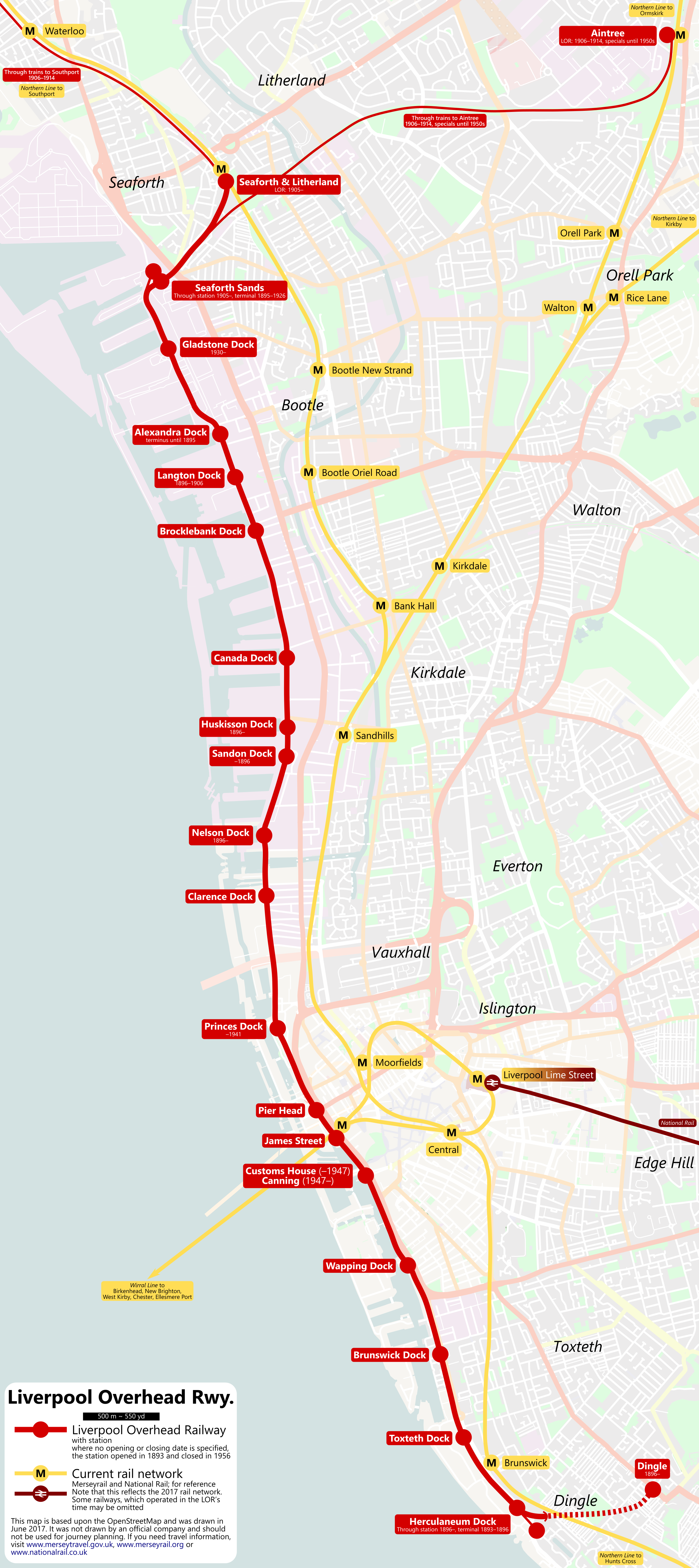
449:
160:
26:
1:
433:
165:Eine geographische Karte der
36:
475:Items portrayed in this file
306:Open Database License (ODbL)
290:
198:OpenStreetMap-Contributors,
224:This map was created from
827:
758:Usage on www.wikidata.org
752:Liverpool Overhead Railway
748:Usage on uk.wikipedia.org
738:Usage on ru.wikipedia.org
732:Liverpool Overhead Railway
728:Usage on pl.wikipedia.org
722:Liverpool Overhead Railway
718:Usage on de.wikipedia.org
699:Liverpool Overhead Railway
399:same or compatible license
259:OpenStreetMap contributors
167:Liverpool Overhead Railway
155:Liverpool Overhead Railway
596:
16:
452:
365:
153:Geographical map of the
104:This is a file from the
683:
653:
427:
264:
254:
244:
236:
216:
194:
184:
177:
174:
140:
108:. Information from its
704:Transport in Liverpool
111:description page there
46:Size of this preview:
783:Horizontal resolution
319:Open Database License
279:Open Database License
314:CC-BY-SA-2.0 license
70:2,500 × 5,604 pixels
791:Vertical resolution
662:20:24, 16 June 2017
632:16:21, 23 June 2017
380:– to adapt the work
52:Other resolutions:
240:(see file history)
66:457 × 1,024 pixels
814:
813:
710:Global file usage
687:
533:copyright license
461:
446:
445:
442:
334:
333:
317:
273:
270:Reusing this file
249:openstreetmap.org
231:
205:
204:
126:
125:
106:Wikimedia Commons
32:Global file usage
818:
808:
806:www.inkscape.org
780:
674:
644:
497:copyright status
440:
439:
437:
436:
421:
418:
415:
412:
409:
401:as the original.
358:Creative Commons
352:
351:
347:
346:
341:
340:
329:
326:
323:
320:
311:
295:
288:
267:
229:
220:
214:
180:
164:
152:
144:
138:
122:
101:
100:
94:
88:
86:
73:
62:342 × 768 pixels
58:214 × 480 pixels
54:107 × 240 pixels
48:267 × 599 pixels
826:
825:
821:
820:
819:
817:
816:
815:
804:
768:
708:
688:
680:
672:
650:
642:
598:
597:
594:
593:
592:
591:
590:
589:
588:
587:
585:
575:
574:
573:
571:
560:
559:
558:
557:
556:
555:
554:
553:
551:
539:
538:
537:
535:
524:
523:
522:
521:
520:
519:
518:
517:
515:
503:
502:
501:
499:
488:
487:
486:
485:
484:
482:
466:
465:
464:
447:
434:
431:
423:
422:
419:
416:
413:
410:
407:
406:
364:
353:
327:
324:
321:
318:
260:
232:
218:
211:
206:
170:
158:
142:
135:
128:
127:
116:
115:
114:is shown below.
90:
84:
82:
75:
74:
51:
12:
11:
5:
824:
822:
812:
811:
810:
809:
800:
796:
795:
792:
788:
787:
784:
771:
767:
766:
765:
764:
756:
755:
754:
746:
745:
744:
736:
735:
734:
726:
725:
724:
712:
711:
707:
706:
701:
692:
691:
686:
685:
682:
678:
675:
671:2,500 × 5,604
669:
664:
659:
656:
655:
652:
648:
645:
641:2,500 × 5,604
639:
634:
629:
625:
624:
621:
618:
615:
612:
609:
602:
601:
586:
583:
581:
580:
579:
578:
577:
576:
572:
567:
565:
564:
563:
562:
561:
552:
547:
545:
544:
543:
542:
541:
540:
536:
531:
529:
528:
527:
526:
525:
516:
511:
509:
508:
507:
506:
505:
504:
500:
495:
493:
492:
491:
490:
489:
483:
478:
476:
473:
472:
471:
470:
469:
458:
457:
454:
451:
444:
443:
429:
428:Georeferencing
425:
424:
405:
404:
403:
402:
392:
383:
382:
381:
375:
368:You are free:
355:
354:
336:
332:
331:
298:
296:
274:
262:
261:
258:
256:
252:
251:
246:
242:
241:
238:
234:
233:
223:
221:
212:
210:
207:
203:
202:
196:
192:
191:
186:
182:
181:
176:
172:
171:
145:
136:
134:
131:
129:
124:
123:
102:
92:
91:
45:
41:
40:
39:
34:
29:
24:
19:
13:
10:
9:
6:
4:
3:
2:
823:
807:
803:
801:
799:Software used
798:
793:
790:
785:
782:
778:
775:
769:
763:
760:
759:
757:
753:
750:
749:
747:
743:
740:
739:
737:
733:
730:
729:
727:
723:
720:
719:
717:
716:
715:
709:
705:
702:
700:
697:
695:
689:
681:
676:
670:
668:
665:
663:
660:
658:
657:
651:
646:
640:
638:
635:
633:
630:
627:
626:
622:
619:
616:
613:
610:
608:
607:
605:
599:
570:
550:
534:
514:
498:
481:
438:
430:
426:
411:CC BY-SA 2.0
400:
396:
393:
390:
387:
386:
384:
379:
376:
373:
370:
369:
367:
366:
362:
359:
342:
330:
315:
309:
307:
303:
302:OpenStreetMap
299:
297:
294:
289:
286:
284:
280:
275:
271:
266:
263:
257:
253:
250:
247:
243:
239:
235:
227:
226:OpenStreetMap
222:
215:
208:
201:
197:
193:
190:
189:OpenStreetMap
187:
183:
173:
168:
163:
156:
151:
146:
139:
132:
120:
113:
112:
107:
103:
96:
95:
89:
80:
79:Original file
71:
67:
63:
59:
55:
49:
44:
38:
35:
33:
30:
28:
25:
23:
20:
18:
15:
776:
773:
713:
693:
603:
600:File history
584:16 June 2017
394:
388:
377:
371:
310:
276:
179:16 June 2017
161:
149:
119:You can help
109:
77:
22:File history
513:copyrighted
395:share alike
389:attribution
217:Description
141:Description
690:File usage
617:Dimensions
265:Permission
27:File usage
794:98.43 dpc
786:98.43 dpc
679:Metrophil
673:(3.52 MB)
649:Metrophil
643:(3.49 MB)
614:Thumbnail
611:Date/Time
569:inception
209:Licensing
200:Metrophil
162:Deutsch:
150:English:
85:image/png
770:Metadata
456:Captions
378:to remix
372:to share
363:license.
37:Metadata
762:Q386424
628:current
623:Comment
480:depicts
460:English
283:details
255:Creator
133:Summary
81:
245:Source
195:Author
185:Source
620:User
420:true
417:true
328:true
322:ODbL
237:Date
175:Date
17:File
308:.
68:|
64:|
60:|
56:|
50:.
281:(
272:)
268:(
121:.
87:)
72:.
Text is available under the Creative Commons Attribution-ShareAlike License. Additional terms may apply.