289:
219:
233:
257:
295:
300:
67:
1151:
121:
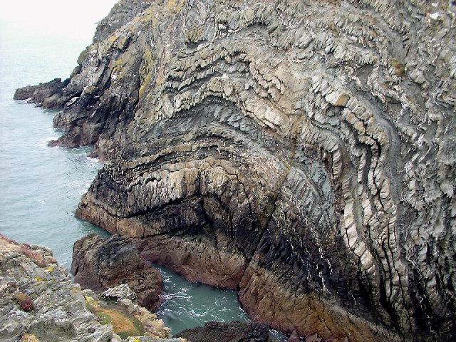
Sea cliff at South Stack. The photo was taken from South Stack itself, looking across the narrow channel separating the stack from Holy Island. The rocks are pre-Cambrian
Greywackes and are approx 600 million years old. The rocks have been contorted and twisted by high pressure and temperature in the
210:
1168:== {{int:filedesc}} == {{Information |description={{en|1=Sea cliff at South Stack. The photo was taken from South Stack itself, looking across the narrow channel separating the stack from Holy Island. The rocks are pre-cambrian Greywackes and are approx 6
38:
347:– You must give appropriate credit, provide a link to the license, and indicate if changes were made. You may do so in any reasonable manner, but not in any way that suggests the licensor endorses you or your use.
78:
46:
1312:
917:
599:
563:
527:
226:
634:
1343:
264:
1198:
This file contains additional information, probably added from the digital camera or scanner used to create or digitize it.
1059:
354:
477:
1150:
1145:
37:
1079:
1009:
975:
938:
883:
849:
812:
775:
738:
704:
642:
583:
511:
485:
470:
455:
910:
670:
627:
612:
547:
428:
411:
1043:
251:
310:
1201:
If the file has been modified from its original state, some details may not fully reflect the modified file.
1378:
1187:
353:– If you remix, transform, or build upon the material, you must distribute your contributions under the
271:
on the
Geograph website for the photographer's contact details. The copyright on this image is owned by
1161:
1228:
307:
1414:
86:
179:
1487:
1182:
649:
619:
462:
163:
232:
1450:
1396:
1235:
276:
73:
1497:
1460:
1275:
1424:
131:
1255:
216:
152:
142:
1507:
1245:
256:
1218:
268:
1118:
Click on a date/time to view the file as it appeared at that time.
218:
201:
61:
697:
211:
53° 18′ 24″ N, 4° 41′ 46″ W
395:
Add a one-line explanation of what this file represents
111:
Sea cliff at South Stack - geograph.org.uk - 113500.jpg
47:
Sea_cliff_at_South_Stack_-_geograph.org.uk_-_113500.jpg
105:
85:
Commons is a freely licensed media file repository.
564:
Creative
Commons Attribution-ShareAlike 2.0 Generic
51:(640 × 480 pixels, file size: 208 KB, MIME type:
364:https://creativecommons.org/licenses/by-sa/2.0
66:
370:Creative Commons Attribution-Share Alike 2.0
288:
8:
330:– to copy, distribute and transmit the work
1203:
1120:
391:
899:d1586a01c7f49206d30adef4d6cacd36bb024d0d
620:https://www.geograph.org.uk/photo/113500
463:https://www.geograph.org.uk/profile/1667
1515:
1505:
1495:
1485:
1477:
1469:
1458:
1448:
1440:
1432:
1422:
1412:
1404:
1394:
1386:
1376:
1368:
1360:
1352:
1341:
1333:
1325:
1317:
1307:
1299:
1291:
1283:
1272:
1264:
1253:
1243:
1233:
1223:
1205:
1180:
1093:
1077:
1057:
1041:
1023:
1007:
989:
973:
952:
936:
897:
881:
863:
847:
826:
810:
789:
773:
752:
736:
718:
702:
684:
668:
597:
581:
561:
545:
525:
509:
442:
426:
409:
406:
387:
380:
204:
225:View this and other nearby images on:
1213:
1178:The following 2 pages use this file:
7:
1313:Adobe Photoshop Elements 4.0 Windows
275:and is licensed for reuse under the
1109:
311:Attribution-Share Alike 2.0 Generic
299:
294:
279:Attribution-ShareAlike 2.0 license.
1196:
400:
394:
285:
262:
115:
98:
44:
399:
1266:Date and time of data generation
385:
341:Under the following conditions:
306:This file is licensed under the
298:
293:
287:
255:
231:
217:
65:
21:
382:
116:
41:No higher resolution available.
14:
600:file available on the internet
381:
263:This image was taken from the
26:
1:
1219:SAMSUNG
705:coordinates of depicted place
31:
635:Geograph Britain and Ireland
471:object of statement has role
407:Items portrayed in this file
1354:Date and time of digitizing
1537:
1471:Focal length in 35 mm film
355:same or compatible license
192:Phil Champion /
173:Phil Champion /
1319:File change date and time
1110:
720:53°18'24.1"N, 4°41'45.6"W
16:
643:geograph.org.uk image ID
384:
321:
194:Sea cliff at South Stack
175:Sea cliff at South Stack
72:This is a file from the
1434:Custom image processing
1167:
164:required by the license
148:
137:
130:
127:
108:
76:. Information from its
1517:Subject distance range
1362:Image compression mode
1322:21:45, 28 January 2006
1146:12:10, 31 January 2010
269:this photograph's page
237:53.306700; -4.696000
79:description page there
1388:Maximum land aperture
1293:Horizontal resolution
1188:South Stack Formation
1357:16:42, 27 March 2005
1269:16:42, 27 March 2005
911:determination method
1327:Y and C positioning
1301:Vertical resolution
1240:1/64 sec (0.015625)
1215:Camera manufacturer
336:– to adapt the work
1479:Scene capture type
1419:Flash did not fire
486:author name string
1524:
1523:
1391:3.4 APEX (f/3.25)
1183:Holy Island Group
1171:
548:copyright license
393:
284:
283:
267:collection. See
242:
241:
199:
198:
167:
94:
93:
74:Wikimedia Commons
1528:
1335:Exposure Program
1204:
1158:
1098:
957:
920:
915:
831:
794:
757:
652:
647:
637:
632:
622:
617:
613:described at URL
512:copyright status
493:
490:
480:
475:
465:
460:
377:
374:
371:
368:
365:
357:as the original.
319:
308:Creative Commons
302:
301:
297:
296:
291:
290:
277:Creative Commons
265:Geograph project
259:
252:
238:
235:
221:
220:
214:
213:
202:
161:
133:
120:
112:
106:
90:
69:
68:
62:
56:
54:
1536:
1535:
1531:
1530:
1529:
1527:
1526:
1525:
1370:APEX brightness
1365:3.5817833333333
1229:D250 DigitalCAM
1192:
1172:
1164:
1156:
1112:
1111:
1108:
1107:
1106:
1105:
1104:
1103:
1102:
1101:
1099:
1096:
1086:
1085:
1084:
1082:
1071:
1070:
1069:
1068:
1067:
1066:
1065:
1064:
1062:
1050:
1049:
1048:
1046:
1035:
1034:
1033:
1032:
1031:
1030:
1029:
1028:
1026:
1016:
1015:
1014:
1012:
1001:
1000:
999:
998:
997:
996:
995:
994:
992:
982:
981:
980:
978:
967:
966:
965:
964:
963:
962:
961:
960:
958:
955:
945:
944:
943:
941:
930:
929:
928:
927:
926:
925:
924:
923:
922:
921:
916:
913:
904:
903:
902:
900:
890:
889:
888:
886:
875:
874:
873:
872:
871:
870:
869:
868:
866:
856:
855:
854:
852:
841:
840:
839:
838:
837:
836:
835:
834:
832:
829:
819:
818:
817:
815:
804:
803:
802:
801:
800:
799:
798:
797:
795:
792:
782:
781:
780:
778:
767:
766:
765:
764:
763:
762:
761:
760:
758:
755:
745:
744:
743:
741:
730:
729:
728:
727:
726:
725:
724:
723:
721:
711:
710:
709:
707:
696:
695:
694:
693:
692:
691:
690:
689:
687:
677:
676:
675:
673:
662:
661:
660:
659:
658:
657:
656:
655:
654:
653:
648:
645:
639:
638:
633:
630:
624:
623:
618:
615:
606:
605:
604:
602:
590:
589:
588:
586:
575:
574:
573:
572:
571:
570:
569:
568:
566:
554:
553:
552:
550:
539:
538:
537:
536:
535:
534:
533:
532:
530:
518:
517:
516:
514:
503:
502:
501:
500:
499:
498:
497:
496:
495:
494:
491:
488:
482:
481:
476:
473:
467:
466:
461:
458:
449:
448:
447:
445:
435:
434:
433:
431:
420:
419:
418:
417:
416:
414:
398:
397:
396:
379:
378:
375:
372:
369:
366:
363:
362:
320:
317:
314:
303:
280:
250:
236:
209:
208:
205:Object location
200:
189:
182:
170:
143:geograph.org.uk
123:
110:
103:
96:
95:
84:
83:
82:is shown below.
58:
52:
50:
43:
42:
12:
11:
5:
1534:
1532:
1522:
1521:
1518:
1514:
1513:
1510:
1504:
1503:
1500:
1494:
1493:
1490:
1484:
1483:
1480:
1476:
1475:
1472:
1468:
1467:
1464:
1457:
1456:
1453:
1447:
1446:
1443:
1439:
1438:
1437:Custom process
1435:
1431:
1430:
1427:
1421:
1420:
1417:
1411:
1410:
1407:
1403:
1402:
1399:
1393:
1392:
1389:
1385:
1384:
1381:
1375:
1374:
1371:
1367:
1366:
1363:
1359:
1358:
1355:
1351:
1350:
1347:
1340:
1339:
1338:Normal program
1336:
1332:
1331:
1328:
1324:
1323:
1320:
1316:
1315:
1310:
1306:
1305:
1302:
1298:
1297:
1294:
1290:
1289:
1286:
1282:
1281:
1278:
1271:
1270:
1267:
1263:
1262:
1259:
1252:
1251:
1248:
1242:
1241:
1238:
1232:
1231:
1226:
1222:
1221:
1216:
1212:
1211:
1208:
1195:
1191:
1190:
1185:
1176:
1175:
1170:
1169:
1166:
1162:
1159:
1153:
1148:
1143:
1139:
1138:
1135:
1132:
1129:
1126:
1123:
1116:
1115:
1100:
1094:
1092:
1091:
1090:
1089:
1088:
1087:
1083:
1078:
1076:
1075:
1074:
1073:
1072:
1063:
1058:
1056:
1055:
1054:
1053:
1052:
1051:
1047:
1042:
1040:
1039:
1038:
1037:
1036:
1027:
1024:
1022:
1021:
1020:
1019:
1018:
1017:
1013:
1008:
1006:
1005:
1004:
1003:
1002:
993:
990:
988:
987:
986:
985:
984:
983:
979:
974:
972:
971:
970:
969:
968:
959:
953:
951:
950:
949:
948:
947:
946:
942:
937:
935:
934:
933:
932:
931:
909:
908:
907:
906:
905:
901:
898:
896:
895:
894:
893:
892:
891:
887:
882:
880:
879:
878:
877:
876:
867:
864:
862:
861:
860:
859:
858:
857:
853:
848:
846:
845:
844:
843:
842:
833:
827:
825:
824:
823:
822:
821:
820:
816:
811:
809:
808:
807:
806:
805:
796:
790:
788:
787:
786:
785:
784:
783:
779:
774:
772:
771:
770:
769:
768:
759:
753:
751:
750:
749:
748:
747:
746:
742:
737:
735:
734:
733:
732:
731:
722:
719:
717:
716:
715:
714:
713:
712:
708:
703:
701:
700:
699:
698:
688:
685:
683:
682:
681:
680:
679:
678:
674:
669:
667:
666:
665:
664:
663:
641:
640:
626:
625:
611:
610:
609:
608:
607:
603:
598:
596:
595:
594:
593:
592:
591:
587:
584:source of file
582:
580:
579:
578:
577:
576:
567:
562:
560:
559:
558:
557:
556:
555:
551:
546:
544:
543:
542:
541:
540:
531:
526:
524:
523:
522:
521:
520:
519:
515:
510:
508:
507:
506:
505:
504:
484:
483:
469:
468:
454:
453:
452:
451:
450:
446:
443:
441:
440:
439:
438:
437:
436:
432:
427:
425:
424:
423:
422:
421:
415:
410:
408:
405:
404:
403:
402:
401:
390:
389:
386:
383:
361:
360:
359:
358:
348:
339:
338:
337:
331:
324:You are free:
315:
305:
304:
286:
282:
281:
260:
249:
246:
240:
239:
229:
223:
206:
197:
196:
190:
187:
184:
183:
178:
171:
168:
156:
155:
150:
146:
145:
139:
135:
134:
129:
125:
124:
122:earth's crust.
113:
104:
102:
99:
97:
92:
91:
70:
60:
59:
40:
36:
35:
34:
29:
24:
19:
13:
10:
9:
6:
4:
3:
2:
1533:
1519:
1516:
1511:
1509:
1506:
1501:
1499:
1496:
1491:
1489:
1486:
1481:
1478:
1473:
1470:
1465:
1462:
1459:
1454:
1452:
1451:White balance
1449:
1445:Auto exposure
1444:
1442:Exposure mode
1441:
1436:
1433:
1428:
1426:
1423:
1418:
1416:
1413:
1408:
1405:
1400:
1398:
1397:Metering mode
1395:
1390:
1387:
1382:
1380:
1379:Exposure bias
1377:
1372:
1369:
1364:
1361:
1356:
1353:
1348:
1345:
1342:
1337:
1334:
1329:
1326:
1321:
1318:
1314:
1311:
1309:Software used
1308:
1303:
1300:
1295:
1292:
1287:
1284:
1279:
1277:
1273:
1268:
1265:
1260:
1257:
1254:
1249:
1247:
1244:
1239:
1237:
1236:Exposure time
1234:
1230:
1227:
1224:
1220:
1217:
1214:
1209:
1206:
1202:
1199:
1193:
1189:
1186:
1184:
1181:
1179:
1173:
1165:
1160:
1154:
1152:
1149:
1147:
1144:
1141:
1140:
1136:
1133:
1130:
1127:
1124:
1122:
1121:
1119:
1113:
1081:
1061:
1045:
1011:
977:
940:
939:exposure time
919:
912:
885:
851:
814:
777:
740:
706:
686:27 March 2005
672:
651:
644:
636:
629:
621:
614:
601:
585:
565:
549:
529:
513:
492:Phil Champion
487:
479:
472:
464:
457:
430:
413:
367:CC BY-SA 2.0
356:
352:
349:
346:
343:
342:
340:
335:
332:
329:
326:
325:
323:
322:
318:Phil Champion
316:Attribution:
312:
309:
292:
278:
274:
273:Phil Champion
270:
266:
261:
258:
254:
253:
247:
245:
244:
234:
230:
228:
227:OpenStreetMap
224:
222:
212:
207:
203:
195:
191:
186:
185:
181:
177: /
176:
172:
165:
160:
158:
157:
154:
153:Phil Champion
151:
147:
144:
140:
136:
132:27 March 2005
126:
119:
114:
107:
100:
88:
81:
80:
75:
71:
64:
63:
57:
48:
39:
33:
30:
28:
25:
23:
20:
18:
15:
1520:Distant view
1461:Digital zoom
1406:Light source
1276:focal length
1225:Camera model
1210:S2500079.JPG
1200:
1197:
1177:
1117:
1114:File history
1080:focal length
478:photographer
350:
344:
333:
327:
272:
243:
193:
180:CC BY-SA 2.0
174:
117:
87:You can help
77:
45:
22:File history
1425:Color space
1285:Orientation
1207:Image title
1163:GeographBot
1044:instance of
528:copyrighted
351:share alike
345:attribution
159:Attribution
109:Description
1498:Saturation
1401:Multi-Spot
1174:File usage
1155:640 × 480
1131:Dimensions
1097:millimetre
1060:photograph
865:image/jpeg
850:media type
444:some value
53:image/jpeg
27:File usage
1508:Sharpness
1256:ISO speed
1128:Thumbnail
1125:Date/Time
1010:ISO speed
954:0.015625
739:data size
671:inception
248:Licensing
188:InfoField
169:InfoField
118:English:
1488:Contrast
1482:Standard
1330:Co-sited
1246:F-number
1194:Metadata
1157:(208 KB)
976:f-number
884:checksum
754:213,483
628:operator
388:Captions
334:to remix
328:to share
313:license.
32:Metadata
1409:Unknown
1346:version
1250:f/3.432
1142:current
1137:Comment
429:creator
412:depicts
392:English
101:Summary
49:
1502:Normal
1492:Normal
1304:72 dpi
1296:72 dpi
1288:Normal
1258:rating
956:second
776:height
650:113500
215:
149:Author
138:Source
1463:ratio
1415:Flash
1373:5.558
1274:Lens
991:3.432
918:SHA-1
830:pixel
813:width
793:pixel
141:From
1512:Soft
1474:0 mm
1429:sRGB
1344:Exif
1280:5 mm
1134:User
828:640
791:480
756:byte
376:true
373:true
128:Date
17:File
1349:2.2
456:URL
1261:70
1095:5
1025:70
914::
646::
631::
616::
489::
474::
459::
1466:1
1455:6
1383:0
166:)
162:(
89:.
55:)
Text is available under the Creative Commons Attribution-ShareAlike License. Additional terms may apply.
_&language=en)
