333:
43:
288:
339:
137:
99:
679:
649:
619:
589:
1006:
773:
388:– You must give appropriate credit, provide a link to the license, and indicate if changes were made. You may do so in any reasonable manner, but not in any way that suggests the licensor endorses you or your use.
1116:
821:
788:
783:
778:
1016:
1076:
961:
793:
1026:
305:
163:
for more information. If an SVG form of this image is available, please upload it and afterwards replace this template with
1111:
1106:
733:
743:
160:
763:
916:
996:
748:
666:
Change of name as West
Philippine Sea as used to describe the Philippines official claim as used by the Philippine Government and Media.
303:; with no Invariant Sections, no Front-Cover Texts, and no Back-Cover Texts. A copy of the license is included in the section entitled
295:
1182:
901:
971:
534:
517:
481:
1036:
718:
636:
Reverted to version as of 16:54, 28 August 2009. The name "West
Philippine Sea" is a neologism and is not neutral.
1159:
This file contains additional information, probably added from the digital camera or scanner used to create or digitize it.
65:
61:
57:
53:
47:
240:
110:
738:
723:
465:
300:
180:
166:
78:
701:
501:
448:
986:
728:
1056:
678:
673:
648:
643:
618:
613:
606:
Extending EEZ boundaries to include Benham Rise
Extended EEZ and Philippines-Indonesia EEZ Delimitation Agreement
154:
700:, showing internal waters, territorial sea, international treaty limits and exclusive economic zone.}} |Source=
1162:
If the file has been modified from its original state, some details may not fully reflect the modified file.
758:
1146:
659:
349:
911:
346:
223:, showing internal waters, territorial sea, international treaty limits and exclusive economic zone.
118:
753:
282:
1066:
293:
Permission is granted to copy, distribute and/or modify this document under the terms of the
150:
629:
588:
583:
69:
42:
1091:
357:
279:, the copyright holder of this work, hereby publishes it under the following licenses:
276:
255:
689:
599:
105:
768:
179:
It is recommended to name the SVG file “Ph
Territorial Map.svg”—then the template
981:
1046:
697:
259:
1131:
184:
881:
976:
856:
220:
866:
876:
846:
774:
User:TagaSanPedroAko/Original contents of
Presidency of Rodrigo Duterte
946:
871:
926:
1096:
556:
Click on a date/time to view the file as it appeared at that time.
841:
831:
1141:
966:
956:
891:
131:
93:
1086:
258:; addition of Benham Rise and Indo-PH EEZs: Ervin Malicdem (
861:
696:{{Information |Description= {{en|Territorial map of the
432:
Add a one-line explanation of what this file represents
244:
811:
936:
83:(1,827 × 1,877 pixels, file size: 612 KB, MIME type:
789:
Knowledge:Graphics Lab/Map workshop/Archive/May 2014
784:
Knowledge:Graphics Lab/Map workshop/Archive/Jun 2024
779:
Knowledge:Graphics Lab/Map workshop/Archive/Apr 2013
535:
299:, Version 1.2 or any later version published by the
203:
117:
Commons is a freely licensed media file repository.
1126:
794:Knowledge talk:Tambayan Philippines/Archive 16
98:
332:
8:
1171:xmp.did:816294d4-d7ec-1e40-8ed6-6135d9e1af7e
395:https://creativecommons.org/licenses/by/2.5
371:– to copy, distribute and transmit the work
1164:
1092:Eksklusibong sonang ekonomiko ng Pilipinas
558:
428:
413:You may select the license of your choice.
804:The following other wikis use this file:
518:Creative Commons Attribution 2.5 Generic
159:. This has several advantages; see
1179:
1174:
1166:
734:Commercial fisheries in the Philippines
716:
532:
515:
499:
479:
463:
446:
443:
424:
417:
744:Municipal fisheries in the Philippines
714:The following 16 pages use this file:
7:
764:User:Jose Edmundo Dayot/PIL Module 4
311:http://www.gnu.org/copyleft/fdl.html
1047:Wikipedysta:Khan Tengri/brudnopis13
749:Philippines and the Spratly Islands
547:
338:
1157:
437:
431:
412:
362:
329:
275:
213:
142:
130:
76:
1183:Adobe Photoshop CC 2015 (Windows)
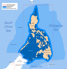
436:
401:Creative Commons Attribution 2.5
358:Roel Balingit (username: Namayan)
277:Roel Balingit (username: Namayan)
256:Roel Balingit (username: Namayan)
422:
382:Under the following conditions:
345:This file is licensed under the
337:
331:
287:
286:
135:
97:
31:
21:
419:
219:Territorial map claimed by the
214:
14:
1168:Unique ID of original document
719:Aquaculture in the Philippines
418:
317:GNU Free Documentation License
306:GNU Free Documentation License
296:GNU Free Documentation License
232:25 June 2007 (original upload)
26:
1:
867:Utilisateur:Skiff/A illustrer
36:
739:Fisheries in the Philippines
724:Baselines of the Philippines
444:Items portrayed in this file
1053:Usage on pnb.wikipedia.org
1023:Usage on mdf.wikipedia.org
923:Usage on ilo.wikipedia.org
908:Usage on he.wiktionary.org
1204:
1138:Usage on zh.wikipedia.org
1123:Usage on vi.wikipedia.org
1103:Usage on uk.wikipedia.org
1083:Usage on tl.wikipedia.org
1073:Usage on th.wikipedia.org
1063:Usage on sk.wikipedia.org
1043:Usage on pl.wikipedia.org
1033:Usage on pa.wikipedia.org
1013:Usage on kn.wikipedia.org
1003:Usage on km.wikipedia.org
993:Usage on ka.wikipedia.org
953:Usage on ja.wikipedia.org
943:Usage on it.wikipedia.org
933:Usage on io.wikipedia.org
898:Usage on he.wikipedia.org
888:Usage on gl.wikipedia.org
882:Conflit des îles Spratleys
853:Usage on fr.wikipedia.org
847:Geographie der Philippinen
838:Usage on de.wikipedia.org
828:Usage on cs.wikipedia.org
818:Usage on bn.wikipedia.org
808:Usage on af.wikipedia.org
729:Borders of the Philippines
147:image could be re-created
1117:Державний кордон Філіппін
947:Geografia delle Filippine
857:Zone économique exclusive
548:
161:Commons:Media for cleanup
16:
421:
301:Free Software Foundation
181:Vector version available
167:vector version available
104:This is a file from the
1067:Výlučná ekonomická zóna
877:Récif de Johnson du Sud
759:Spratly Islands dispute
695:
665:
635:
605:
350:Attribution 2.5 Generic
251:
236:
231:
228:
206:
108:. Information from its
1097:Hangganan ng Pilipinas
972:利用者:Henares/いろいろ/aliño
927:Heograpia ti Filipinas
209:Ph Territorial Map.png
111:description page there
46:Size of this preview:
674:16:54, 28 August 2009
1132:Biển Tây Philippines
1007:ភូមិសាស្ត្រហ្វីលីពីន
872:Récif de Scarborough
187:) does not need the
70:1,827 × 1,877 pixels
1027:Территориять веттне
704:|Date={{date|2007-0
584:05:58, 19 July 2015
377:– to adapt the work
52:Other resolutions:
1112:Географія Філіппін
1107:Територіальні води
892:Augas territoriais
66:997 × 1,024 pixels
1191:
1190:
800:Global file usage
754:Scarborough Shoal
707:
702:English Knowledge
661:Jeromesandilanico
644:08:13, 4 May 2012
614:11:33, 8 May 2012
502:copyright license
430:
328:
327:
266:
265:
241:English Knowledge
196:
195:
126:
125:
106:Wikimedia Commons
32:Global file usage
1195:
1185:
1165:
1017:ಮೀಸಲು ಆರ್ಥಿಕ ವಲಯ
917:מים טריטוריאליים
902:אזור כלכלי בלעדי
842:Archipelgewässer
832:Souostrovní vody
822:ফিলিপাইনের ভূগোল
686:
656:
626:
596:
466:copyright status
408:
405:
402:
399:
396:
360:
347:Creative Commons
341:
340:
335:
334:
324:
321:
318:
315:
312:
290:
289:
283:
218:
210:
204:
174:
139:
138:
132:
122:
101:
100:
94:
88:
86:
73:
62:748 × 768 pixels
58:467 × 480 pixels
54:234 × 240 pixels
48:584 × 600 pixels
1203:
1202:
1198:
1197:
1196:
1194:
1193:
1192:
1181:
1153:
1087:Talampas Benham
798:
708:
692:
684:
662:
654:
632:
624:
602:
594:
550:
549:
546:
545:
544:
543:
542:
541:
540:
539:
537:
526:
525:
524:
523:
522:
520:
508:
507:
506:
504:
493:
492:
491:
490:
489:
488:
487:
486:
484:
472:
471:
470:
468:
457:
456:
455:
454:
453:
451:
435:
434:
433:
416:
415:
414:
410:
409:
406:
403:
400:
397:
394:
393:
361:
356:
353:
342:
322:
319:
316:
313:
310:
281:
280:
272:
267:
224:
208:
201:
192:
164:
151:vector graphics
136:
128:
127:
116:
115:
114:is shown below.
90:
84:
82:
75:
74:
51:
12:
11:
5:
1201:
1199:
1189:
1188:
1187:
1186:
1177:
1173:
1172:
1169:
1156:
1152:
1151:
1150:
1149:
1144:
1136:
1135:
1134:
1129:
1121:
1120:
1119:
1114:
1109:
1101:
1100:
1099:
1094:
1089:
1081:
1080:
1079:
1077:น่านน้ำอาณาเขต
1071:
1070:
1069:
1061:
1060:
1059:
1051:
1050:
1049:
1041:
1040:
1039:
1031:
1030:
1029:
1021:
1020:
1019:
1011:
1010:
1009:
1001:
1000:
999:
991:
990:
989:
984:
979:
974:
969:
964:
959:
951:
950:
949:
941:
940:
939:
931:
930:
929:
921:
920:
919:
914:
906:
905:
904:
896:
895:
894:
886:
885:
884:
879:
874:
869:
864:
859:
851:
850:
849:
844:
836:
835:
834:
826:
825:
824:
816:
815:
814:
802:
801:
797:
796:
791:
786:
781:
776:
771:
766:
761:
756:
751:
746:
741:
736:
731:
726:
721:
712:
711:
706:
705:
694:
690:
687:
683:1,827 × 1,790
681:
676:
671:
668:
667:
664:
660:
657:
651:
646:
641:
638:
637:
634:
630:
627:
623:1,827 × 1,790
621:
616:
611:
608:
607:
604:
600:
597:
593:1,827 × 1,877
591:
586:
581:
577:
576:
573:
570:
567:
564:
561:
554:
553:
538:
533:
531:
530:
529:
528:
527:
521:
516:
514:
513:
512:
511:
510:
509:
505:
500:
498:
497:
496:
495:
494:
485:
480:
478:
477:
476:
475:
474:
473:
469:
464:
462:
461:
460:
459:
458:
452:
447:
445:
442:
441:
440:
439:
438:
427:
426:
423:
420:
411:
392:
391:
390:
389:
380:
379:
378:
372:
365:You are free:
354:
344:
343:
330:
326:
325:
291:
274:
273:
271:
268:
264:
263:
253:
249:
248:
238:
234:
233:
230:
226:
225:
211:
202:
200:
197:
194:
193:
189:new image name
171:new image name
140:
129:
124:
123:
102:
92:
91:
45:
41:
40:
39:
34:
29:
24:
19:
13:
10:
9:
6:
4:
3:
2:
1200:
1184:
1180:
1178:
1176:Software used
1175:
1170:
1167:
1163:
1160:
1154:
1148:
1147:Talk:廣大興28號事件
1145:
1143:
1140:
1139:
1137:
1133:
1130:
1128:
1125:
1124:
1122:
1118:
1115:
1113:
1110:
1108:
1105:
1104:
1102:
1098:
1095:
1093:
1090:
1088:
1085:
1084:
1082:
1078:
1075:
1074:
1072:
1068:
1065:
1064:
1062:
1058:
1055:
1054:
1052:
1048:
1045:
1044:
1042:
1038:
1035:
1034:
1032:
1028:
1025:
1024:
1022:
1018:
1015:
1014:
1012:
1008:
1005:
1004:
1002:
998:
995:
994:
992:
988:
985:
983:
980:
978:
975:
973:
970:
968:
965:
963:
962:海洋法に関する国際連合条約
960:
958:
955:
954:
952:
948:
945:
944:
942:
938:
935:
934:
932:
928:
925:
924:
922:
918:
915:
913:
910:
909:
907:
903:
900:
899:
897:
893:
890:
889:
887:
883:
880:
878:
875:
873:
870:
868:
865:
863:
862:Ligne de base
860:
858:
855:
854:
852:
848:
845:
843:
840:
839:
837:
833:
830:
829:
827:
823:
820:
819:
817:
813:
810:
809:
807:
806:
805:
799:
795:
792:
790:
787:
785:
782:
780:
777:
775:
772:
770:
767:
765:
762:
760:
757:
755:
752:
750:
747:
745:
742:
740:
737:
735:
732:
730:
727:
725:
722:
720:
717:
715:
709:
703:
699:
693:
688:
682:
680:
677:
675:
672:
670:
669:
663:
658:
652:
650:
647:
645:
642:
640:
639:
633:
628:
622:
620:
617:
615:
612:
610:
609:
603:
598:
592:
590:
587:
585:
582:
579:
578:
574:
571:
568:
565:
562:
560:
559:
557:
551:
536:
519:
503:
483:
467:
450:
387:
384:
383:
381:
376:
373:
370:
367:
366:
364:
363:
359:
355:Attribution:
351:
348:
336:
308:
307:
302:
298:
297:
292:
285:
284:
278:
269:
261:
257:
254:
250:
246:
242:
239:
235:
227:
222:
217:
212:
205:
198:
190:
186:
182:
178:
177:
172:
168:
162:
158:
156:
152:
146:
141:
134:
133:
120:
113:
112:
107:
103:
96:
95:
89:
80:
79:Original file
71:
67:
63:
59:
55:
49:
44:
38:
35:
33:
30:
28:
25:
23:
20:
18:
15:
1161:
1158:
1057:علاقائی پانی
803:
769:User:Namayan
713:
555:
552:File history
385:
374:
368:
304:
294:
215:
188:
176:
170:
148:
144:
119:You can help
109:
77:
22:File history
997:შიდა წყლები
698:Philippines
482:copyrighted
386:attribution
221:Philippines
207:Description
1037:ਖੇਤਰੀ ਪਾਣੀ
912:מימי חופים
710:File usage
653:612 × 600
631:Sky Harbor
569:Dimensions
398:CC BY 2.5
191:parameter.
27:File usage
812:Filippyne
566:Thumbnail
563:Date/Time
270:Licensing
216:English:
85:image/png
1155:Metadata
987:フィリピンの地理
937:Filipini
691:Mormegil
685:(535 KB)
655:(129 KB)
625:(535 KB)
601:Schadow1
595:(612 KB)
425:Captions
375:to remix
369:to share
352:license.
260:schadow1
37:Metadata
580:current
575:Comment
449:depicts
429:English
199:Summary
81:
1127:Tam Sa
977:基線 (海)
252:Author
237:Source
153:as an
149:using
143:This
982:群島国家
572:User
407:true
404:true
323:true
320:true
314:GFDL
229:Date
183:(or
157:file
17:File
245:log
185:Vva
155:SVG
145:map
1142:领土
967:内水
957:領海
173:}}
165:{{
68:|
64:|
60:|
56:|
50:.
309:.
262:)
247:)
243:(
175:.
169:|
121:.
87:)
72:.
Text is available under the Creative Commons Attribution-ShareAlike License. Additional terms may apply.
