31:
213:
169:
133:
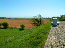
A large area of chalk grassland has three nationally rare plants, and Asholt Wood has outstanding lichen flora. The site also includes
Holywell Coombe, a key geological site displaying the sequence of
38:
973:
388:
54:
328:
983:
191:
93:
862:
978:
379:
689:
832:
789:
524:
479:
409:
396:
107:
22:
897:
684:
126:
grassland site, Grade 2, and the 70-hectare (170-acre) Asholt Wood at its western end is a Grade 1 woodland site. The reserve has a
724:
619:
244:
429:
947:
769:
127:
812:
434:
754:
579:
902:
709:
544:
119:
932:
704:
604:
123:
714:
574:
304:
922:
629:
559:
519:
372:
887:
827:
719:
614:
822:
749:
469:
459:
424:
282:
847:
694:
549:
514:
439:
365:
634:
569:
404:
357:
260:
942:
867:
842:
584:
509:
504:
414:
240:
80:
912:
907:
882:
797:
739:
669:
624:
554:
529:
484:
892:
852:
759:
699:
659:
494:
807:
779:
764:
729:
654:
649:
644:
639:
609:
599:
589:
539:
419:
48:
967:
872:
802:
594:
489:
454:
449:
927:
744:
464:
444:
937:
817:
679:
674:
664:
138:
917:
877:
857:
564:
534:
111:
343:
330:
952:
774:
734:
474:
239:. Vol. 2. Cambridge, UK: Cambridge University Press. pp. 46, 119.
30:
142:
134:
285:. Geological Conservation Review. Joint Nature Conservation Committee
263:. Geological Conservation Review. Joint Nature Conservation Committee
115:
361:
214:"Designated Sites View: Folkestone to Etchinghill Escarpment"
170:"Designated Sites View: Folkestone to Etchinghill Escarpment"
106:
is a 263.2-hectare (650-acre) biological and geological
310:. Sites of Special Scientific Interest. Natural England
194:. Sites of Special Scientific Interest. Natural England
172:. Sites of Special Scientific Interest. Natural England
283:"Holywell Coombe (Quaternary of South-East England)"
261:"Holywell Coombe (Quaternary of South-East England)"
788:
395:
89:
79:
71:
61:
47:
37:
305:"Folkestone to Etchinghill Escarpment citation"
216:. Special Area of Conservation. Natural England
373:
192:"Map of Folkestone to Etchinghill Escarpment"
8:
974:Sites of Special Scientific Interest in Kent
863:Houlder and Monarch Hill Pits, Upper Halling
389:Sites of Special Scientific Interest in Kent
16:
122:. An area of 205 hectares (510 acres) is a
380:
366:
358:
29:
15:
154:
164:
162:
160:
158:
7:
984:Geological Conservation Review sites
838:Folkestone to Etchinghill Escarpment
500:Folkestone to Etchinghill Escarpment
104:Folkestone to Etchinghill Escarpment
17:Folkestone to Etchinghill Escarpment
833:Dungeness, Romney Marsh and Rye Bay
525:Halling to Trottiscliffe Escarpment
480:Dungeness, Romney Marsh and Rye Bay
410:Alkham, Lydden and Swingfield Woods
108:Site of Special Scientific Interest
23:Site of Special Scientific Interest
14:
898:Sandwich Bay to Hacklinge Marshes
690:Scord's Wood and Brockhoult Mount
685:Sandwich Bay to Hacklinge Marshes
979:Nature Conservation Review sites
725:South Thames Estuary and Marshes
620:One Tree Hill and Bitchet Common
430:Chattenden Woods and Lodge Hill
948:Wouldham to Detling Escarpment
770:Wouldham to Detling Escarpment
235:Ratcliffe, Derek, ed. (1977).
128:Geological Conservation Review
1:
755:West Blean and Thornden Woods
580:Lydden and Temple Ewell Downs
110:on the northern outskirts of
903:Sheppey Cliffs and Foreshore
710:Sheppey Cliffs and Foreshore
545:Holborough to Burham Marshes
237:A Nature Conservation Review
120:Special Area of Conservation
813:Chequer's Wood and Old Park
435:Chequer's Wood and Old Park
1000:
933:Tower Hill to Cockham Wood
715:Shorne and Ashenbank Woods
605:Medway Estuary and Marshes
124:Nature Conservation Review
75:263.2 hectares (650 acres)
823:Dover to Kingsdown Cliffs
470:Dover to Kingsdown Cliffs
28:
21:
630:Otford to Shoreham Downs
560:Ileden and Oxenden Woods
520:Great Shuttlesfield Down
888:Pembury Cutting and Pit
953:Wye and Crundale Downs
775:Wye and Crundale Downs
720:Sissinghurst Park Wood
615:Oldbury and Seal Chart
923:Swanscombe Skull Site
750:Trottiscliffe Meadows
705:Sevenoaks Gravel Pits
460:Cowden Pound Pastures
425:Charing Beech Hangers
848:Greatness Brickworks
137:fossils in the late
550:Hollingbourne Downs
515:Great Crabbles Wood
440:Church Woods, Blean
340: /
18:
635:Park Wood, Chilham
570:Larkey Valley Wood
405:Alex Farm Pastures
961:
960:
843:Folkestone Warren
585:Lympne Escarpment
575:Lullingstone Park
505:Folkestone Warren
415:Bourne Alder Carr
101:
100:
991:
913:Spot Lane Quarry
908:Southborough Pit
883:Otterpool Quarry
798:Allington Quarry
740:Tankerton Slopes
670:Queendown Warren
625:Orlestone Forest
555:Hothfield Common
530:Ham Street Woods
485:East Blean Woods
382:
375:
368:
359:
355:
354:
352:
351:
350:
345:
341:
338:
337:
336:
333:
320:
319:
317:
315:
309:
301:
295:
294:
292:
290:
279:
273:
272:
270:
268:
257:
251:
250:
232:
226:
225:
223:
221:
210:
204:
203:
201:
199:
188:
182:
181:
179:
177:
166:
57:
33:
19:
999:
998:
994:
993:
992:
990:
989:
988:
964:
963:
962:
957:
893:Rusthall Common
784:
760:Westerham Mines
700:Seabrook Stream
660:Preston Marshes
495:Farningham Wood
391:
386:
348:
346:
344:51.103°N 1.13°E
342:
339:
334:
331:
329:
327:
326:
324:
323:
313:
311:
307:
303:
302:
298:
288:
286:
281:
280:
276:
266:
264:
259:
258:
254:
247:
234:
233:
229:
219:
217:
212:
211:
207:
197:
195:
190:
189:
185:
175:
173:
168:
167:
156:
151:
66:
53:
12:
11:
5:
997:
995:
987:
986:
981:
976:
966:
965:
959:
958:
956:
955:
950:
945:
940:
935:
930:
925:
920:
915:
910:
905:
900:
895:
890:
885:
880:
875:
870:
868:Hubbard's Hill
865:
860:
855:
850:
845:
840:
835:
830:
825:
820:
815:
810:
805:
800:
794:
792:
786:
785:
783:
782:
780:Yockletts Bank
777:
772:
767:
765:Westerham Wood
762:
757:
752:
747:
742:
737:
732:
727:
722:
717:
712:
707:
702:
697:
695:Scotney Castle
692:
687:
682:
677:
672:
667:
662:
657:
655:Polebrook Farm
652:
647:
645:Parsonage Wood
642:
637:
632:
627:
622:
617:
612:
610:Northward Hill
607:
602:
600:Marden Meadows
597:
592:
590:Lynsore Bottom
587:
582:
577:
572:
567:
562:
557:
552:
547:
542:
537:
532:
527:
522:
517:
512:
510:Gibbin's Brook
507:
502:
497:
492:
487:
482:
477:
472:
467:
462:
457:
452:
447:
442:
437:
432:
427:
422:
420:Brookland Wood
417:
412:
407:
401:
399:
393:
392:
387:
385:
384:
377:
370:
362:
322:
321:
296:
274:
252:
245:
227:
205:
183:
153:
152:
150:
147:
99:
98:
91:
87:
86:
83:
77:
76:
73:
69:
68:
63:
59:
58:
51:
49:Grid reference
45:
44:
41:
35:
34:
26:
25:
13:
10:
9:
6:
4:
3:
2:
996:
985:
982:
980:
977:
975:
972:
971:
969:
954:
951:
949:
946:
944:
941:
939:
936:
934:
931:
929:
926:
924:
921:
919:
916:
914:
911:
909:
906:
904:
901:
899:
896:
894:
891:
889:
886:
884:
881:
879:
876:
874:
873:Lenham Quarry
871:
869:
866:
864:
861:
859:
856:
854:
851:
849:
846:
844:
841:
839:
836:
834:
831:
829:
826:
824:
821:
819:
816:
814:
811:
809:
806:
804:
803:Aylesford Pit
801:
799:
796:
795:
793:
791:
787:
781:
778:
776:
773:
771:
768:
766:
763:
761:
758:
756:
753:
751:
748:
746:
743:
741:
738:
736:
733:
731:
728:
726:
723:
721:
718:
716:
713:
711:
708:
706:
703:
701:
698:
696:
693:
691:
688:
686:
683:
681:
678:
676:
673:
671:
668:
666:
663:
661:
658:
656:
653:
651:
648:
646:
643:
641:
640:Parkgate Down
638:
636:
633:
631:
628:
626:
623:
621:
618:
616:
613:
611:
608:
606:
603:
601:
598:
596:
595:Magpie Bottom
593:
591:
588:
586:
583:
581:
578:
576:
573:
571:
568:
566:
563:
561:
558:
556:
553:
551:
548:
546:
543:
541:
538:
536:
533:
531:
528:
526:
523:
521:
518:
516:
513:
511:
508:
506:
503:
501:
498:
496:
493:
491:
490:Ellenden Wood
488:
486:
483:
481:
478:
476:
473:
471:
468:
466:
463:
461:
458:
456:
455:Cowden Meadow
453:
451:
450:Combwell Wood
448:
446:
443:
441:
438:
436:
433:
431:
428:
426:
423:
421:
418:
416:
413:
411:
408:
406:
403:
402:
400:
398:
394:
390:
383:
378:
376:
371:
369:
364:
363:
360:
356:
353:
306:
300:
297:
284:
278:
275:
262:
256:
253:
248:
242:
238:
231:
228:
215:
209:
206:
193:
187:
184:
171:
165:
163:
161:
159:
155:
148:
146:
144:
140:
136:
131:
129:
125:
121:
117:
113:
109:
105:
97:
96:
92:
88:
84:
82:
78:
74:
70:
64:
60:
56:
52:
50:
46:
42:
40:
36:
32:
27:
24:
20:
943:Wateringbury
928:Thanet Coast
837:
808:Baker's Hole
745:Thanet Coast
499:
465:Darenth Wood
445:Cobham Woods
349:51.103; 1.13
325:
312:. Retrieved
299:
287:. Retrieved
277:
265:. Retrieved
255:
246:0521-21403-3
236:
230:
218:. Retrieved
208:
196:. Retrieved
186:
174:. Retrieved
132:
103:
102:
94:
90:Location map
81:Notification
938:Wansunt Pit
818:Dalham Farm
680:Robins Wood
675:River Beult
665:Purple Hill
650:Peter's Pit
540:Hoad's Wood
347: /
139:Pleistocene
968:Categories
918:Sturry Pit
878:Oaken Wood
858:High Rocks
790:Geological
565:Knole Park
535:Hatch Park
397:Biological
332:51°06′11″N
314:5 February
289:11 January
267:11 January
220:16 January
198:5 February
176:5 February
149:References
118:. It is a
112:Folkestone
67:Geological
65:Biological
55:TR 192 384
853:Hart Hill
735:The Swale
730:Stodmarsh
475:Down Bank
335:1°07′48″E
95:Magic Map
143:Holocene
62:Interest
39:Location
828:Dryhill
135:mollusc
243:
130:site.
308:(PDF)
316:2018
291:2018
269:2018
241:ISBN
222:2018
200:2018
178:2018
141:and
116:Kent
85:1985
72:Area
43:Kent
114:in
970::
157:^
145:.
381:e
374:t
367:v
318:.
293:.
271:.
249:.
224:.
202:.
180:.
Text is available under the Creative Commons Attribution-ShareAlike License. Additional terms may apply.