121:
136:
129:
24:
398:
491:
438:
322:
Mushes
Coppice with Everitts Coppice, Stonyfield Copse, Flagpond Copse, Sager's Moor, Dimmock's Moor, Ridge Copse, Blackmoor Copse, Waterclose Copse and Sawpit Copse
548:
509:
501:
328:
Jacob's Croft, Hangman's Copse, Blacklands Copse, Birch Row, Alder Moor, Maids' Garden Copse and Botley Row (wood that adjoins above group)
271:
Newlandsmoor
Coppice with Malin's Coppice, Drivett's Coppice, Portland Coppice, Potwall Coppice, Broomground Coppice and Greathunt Coppice
395:
120:
191:
107:
420:
41:
496:
553:
88:
45:
60:
435:
195:
67:
350:
487:
164:
319:
Shaftesbury Copse, Aylesbury Copse with Ravens Wood, Birchfield Copse, Dash Wood, Dandy Copse and
Fiddlers Green
74:
135:
337:
223:
34:
56:
251:
355:
Home Wood with
Smithys Wood, Cox's Rough, Hut Wood, Marshall's Rows, Spring Copse and Chilworth Common
128:
467:
325:
Brook Wood with Horse Wood, Hallwood Copse, Mansfield High Wood, Hole Copse and
Silford Copse
459:
81:
124:
The Queen's
Inclosure between the joined suburban settlements of Waterlooville and Cowplain
442:
424:
405:
402:
187:
170:
The former uninterrupted forest is now a mix of woodland, open space, ponds, streams,
542:
416:
365:
179:
274:
Dunsland
Coppice with Wards Coppice and Fareham Garden (wood adjoining above group)
211:
454:
Bazeley, Margaret (1921). "The Extent of the
English Forest in the 13th century".
304:
West Walk (one of the largest woods) (with
Lowerfield Copse and Upperfield Copse)
194:
for walking and cycling. In the southern portion, towards the area south of the
23:
231:
227:
219:
215:
156:
524:
511:
171:
148:
379:
Ampfield Wood with
Neville's Copse, Amprield Plantation and Hursley Forest
183:
175:
471:
199:
152:
214:
formed a greater forerunner of the later vestigial forest between the
127:
295:
Waltonheath Plantation with Ashlands Plantation and Staplecross Copse
226:
was the Royal Forest of Bere Ashley. North of Portsmouth between the
160:
463:
340:
with Dock Copse, Catiland Copse, Vantage Copse and Durncombe's Copse
134:
119:
310:
Mill Copse with Hoegate Commons, The Purlieu and Huntbourn Wood
218:
and the Sussex border. North of Southampton between the rivers
17:
349:
Hog Wood with Milkmeads Copse, Vocus Copse, High Wood and/in
243:
Listed from east to west, excluding small copses and coppices
178:
interspersed by minor villages and the major settlements of
262:
Outhills Copse with Stakehills Coppice and Beech Wood
265:
Bushy Lease with Neville's Park and Littlepark Wood
202:plantations were created in the twentieth century.
48:. Unsourced material may be challenged and removed.
417:http://www3.hants.gov.uk/ltp06-forest-bere-map.pdf
298:Goathouse Copse with Russell Copse and Kiln Wood
361:Home Copse, Long Copse and Rownhams Plantation
346:Telegraph Woods with Beacon Hill Woodland Park
238:Woodland habitats and contiguous country parks
8:
456:Transactions of the Royal Historical Society
139:Bushy Coppice at the eastern end of the area
256:The Holt with Stein Wood and Havant Thicket
234:was the Royal Forest of Bere Portchester.
147:is a mixed-use partially forested area in
108:Learn how and when to remove this message
331:Gull Coppice and Bushy Land, in Swanwick
388:
358:Otterbourne Park Wood and Pitmore Copse
268:The Queen's Inclosure in Waterlooville
307:Dirty Copse with Great Holywell Copse
7:
373:Hocombe Plantation with Trodds Copse
343:Netley Common with Dumbleton's Copse
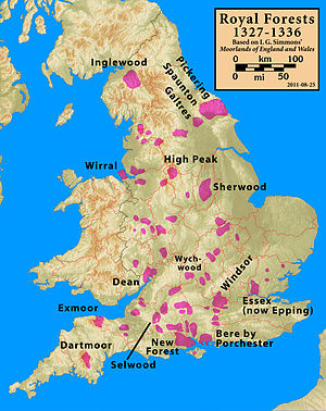
210:In the 13th and 14th centuries, two
46:adding citations to reliable sources
334:Wellspring Copse with Swanwick Wood
549:Forests and woodlands of Hampshire
163:and including a small part of the
14:
313:Orchard Copse with Birching Copse
22:
33:needs additional citations for
301:Grub Coppice with Mill Coppice
1:
364:The woods that cover most of
316:Close Wood and Bishop's Wood
196:Queen Elizabeth Country Park
436:Fareham Visitor Information
570:
351:Itchen Valley Country Park
423:December 2, 2008, at the
190:). There are a number of
165:South Downs National Park
441:January 8, 2009, at the
338:Manor Farm Country Park
502:Fareham Council - Bere
186:) and Eastleigh (with
140:
132:
125:
554:English royal forests
252:Staunton Country Park
151:immediately north of
138:
131:
123:
419:Forest of Bere Map
376:Broadgate Plantation
192:paths and bridleways
42:improve this article
521: /
401:2013-12-19 at the
230:and the suburb of
141:
133:
126:
286:Mitchelland Copse
248:Southleigh Forest
118:
117:
110:
92:
561:
536:
535:
533:
532:
531:
526:
525:50.900°N 1.033°W
522:
519:
518:
517:
514:
476:
475:
451:
445:
433:
427:
414:
408:
393:
159:and Roman Road,
113:
106:
102:
99:
93:
91:
57:"Forest of Bere"
50:
26:
18:
569:
568:
564:
563:
562:
560:
559:
558:
539:
538:
529:
527:
523:
520:
515:
512:
510:
508:
507:
492:Upperford Copse
484:
479:
464:10.2307/3678331
453:
452:
448:
443:Wayback Machine
434:
430:
425:Wayback Machine
415:
411:
406:Ordnance survey
403:Wayback Machine
394:
390:
386:
240:
208:
174:, farmland and
114:
103:
97:
94:
51:
49:
39:
27:
12:
11:
5:
567:
565:
557:
556:
551:
541:
540:
530:50.900; -1.033
505:
504:
499:
497:HollyBank Wood
494:
489:
483:
482:External links
480:
478:
477:
446:
428:
409:
387:
385:
382:
381:
380:
377:
374:
371:
370:Windmill Copse
368:
362:
359:
356:
353:
347:
344:
341:
335:
332:
329:
326:
323:
320:
317:
314:
311:
308:
305:
302:
299:
296:
293:
290:
289:Stroud Coppice
287:
284:
281:
278:
275:
272:
269:
266:
263:
260:
257:
254:
249:
239:
236:
207:
204:
188:Chandlers Ford
145:Forest of Bere
116:
115:
30:
28:
21:
13:
10:
9:
6:
4:
3:
2:
566:
555:
552:
550:
547:
546:
544:
537:
534:
503:
500:
498:
495:
493:
490:
488:
486:
485:
481:
473:
469:
465:
461:
457:
450:
447:
444:
440:
437:
432:
429:
426:
422:
418:
413:
410:
407:
404:
400:
397:
392:
389:
383:
378:
375:
372:
369:
367:
366:Cranbury Park
363:
360:
357:
354:
352:
348:
345:
342:
339:
336:
333:
330:
327:
324:
321:
318:
315:
312:
309:
306:
303:
300:
297:
294:
291:
288:
285:
282:
279:
277:Sawyer's Wood
276:
273:
270:
267:
264:
261:
258:
255:
253:
250:
247:
246:
245:
244:
237:
235:
233:
229:
225:
221:
217:
213:
212:royal forests
205:
203:
201:
197:
193:
189:
185:
181:
180:Waterlooville
177:
173:
168:
166:
162:
158:
154:
150:
146:
137:
130:
122:
112:
109:
101:
90:
87:
83:
80:
76:
73:
69:
66:
62:
59: –
58:
54:
53:Find sources:
47:
43:
37:
36:
31:This article
29:
25:
20:
19:
16:
506:
455:
449:
431:
412:
396:Map from the
391:
292:Hipley Copse
280:Creech Woods
242:
241:
209:
169:
144:
142:
104:
95:
85:
78:
71:
64:
52:
40:Please help
35:verification
32:
15:
528: /
259:Bells Copse
543:Categories
384:References
283:Place Wood
232:Bedhampton
228:River Meon
216:New Forest
157:Portsmouth
68:newspapers
172:heathland
149:Hampshire
439:Archived
421:Archived
399:Archived
184:Cowplain
176:downland
98:May 2013
513:50°54′N
472:3678331
206:History
200:conifer
153:Fareham
82:scholar
516:1°02′W
470:
224:Itchen
182:(with
161:Havant
84:
77:
70:
63:
55:
468:JSTOR
89:JSTOR
75:books
222:and
220:Test
143:The
61:news
460:doi
198:,
44:by
545::
466:.
458:.
167:.
155:,
474:.
462::
111:)
105:(
100:)
96:(
86:·
79:·
72:·
65:·
38:.
Text is available under the Creative Commons Attribution-ShareAlike License. Additional terms may apply.