361:
worked on the actual building of the bridge as well as keeping his uncle's financial records. Louis
Guinard the uncle, fell from the bridge on June 6, 1865 and drowned, leaving the property to his nephew Louis P. Guinard, who took possession on July 15 of 1865. The will was discovered in 1866 and Louis P Guinard stated that he was advised by Major Bullock, sutler at Ft. Laramie, that the will left him as sole owner of the property and that he should remain and hold possession of it. The U.S. troops occupied Guinard's buildings for three years during the Civil War. Louis P. Guinard stated that one of the officers promised him $ 1000 for use of the said buildings but he never received any payment. The bridge was later destroyed by Indians when the troops left in 1865, and with hundreds of Indians appearing on the opposite bank of the river, Guinard felt he had no choice but to leave for the protection of himself and his family. They had gone no more than 4 or 5 miles before he could tell from the smoke columns that the Indians were burning everything. Guinard had left his will in the safekeeping of Major Bullock at Ft. Laramie, having no way at the time to get it probated or secured in a bank. He later filed claim to be compensated for Indian depredations but Major Bullock told him the will was lost or destroyed. Unable to produce the will, the case dragged on in the courts for more than 25 years before it was finally abandoned and Guinard was never compensated for his losses.
406:, that he had earlier passed a small train of five empty mule-drawn wagons returning from Sweetwater to Laramie, 14 teamsters escorted by 11 enlisted men of the 11th Kansas. Knowing that the train was due to come in the next morning, the officers at the post discussed sending out a relief force to drive off the Cheyenne and Lakota warriors, so that the wagon train could come safely in. Leib and Bretney suggested an immediate march but Anderson decided to wait for daylight. Bretney, who had succeeded to command of Company G on February 13 when its captain, Levi M. Rinehart, had been accidentally killed by a drunken trooper during a skirmish, was not on good terms with Anderson. On his arrival at Platte Bridge on July 16, the Kansan had replaced Bretney as post commander and ordered Company G to relocate to Sweetwater Station, escorting the same wagon train now returning from there. In addition, the 11th Kansas Cavalry was due to march to Fort Kearney on or about August 1 to muster out of service.
391:, a party of several thousand Cheyenne and Sioux approached Platte Bridge Station from the north intending to attack the soldiers camped there and destroy the 1,000-foot-long (300 m) bridge. They had previously scouted the area and selected it because the soldiers there were not in the small trading post stockade of 14-foot pine logs but camped in tents. Initially only a small party of Indians showed themselves to the troops, the remainder of the Indians remaining concealed. By the afternoon of July 25, however, when a large raiding party had driven off a number of horses and forced the pursuing cavalry troopers to expend much ammunition, the station had permanent structures and a mountain howitzer of the 11th Ohio Cavalry covered the approaches to the bridge.
910:
442:
ordered a retreat to the bridge through the
Cheyenne to his rear as yet another force, this of Lakota, attempted to rush the bridge. The skirmish line at the bridge held the Lakota at bay with volley fire until 20 of the 26 troopers, all wounded to some extent, fought their way through. Five were killed, including Collins, who was wounded in the hip and shot in the forehead with an arrow while trying to aid a wounded soldier. The battle lasted only a few minutes, with Bent claiming that the Lakota and Cheyenne suffered only a few casualties.
438:
Platte Bridge at a walk, then formed into a column of fours and rode west along the north bank at a trot to drive off any hostile
Indians. Behind him, the contingent of the 3rd U.S.V.I. and its 11th Ohio Volunteer Cavalry escort crossed the bridge on foot as a support force for Collins, forming a skirmish line when they observed several hundred Cheyenne emerge from the sand hills and gulleys between themselves and Collins.
357:. In response, and partly to protect the new telegraph line, the Army began increasing its presence in the region in 1861 by sending a detachment to guard Guinard's bridge. Many of these troops, who created a series of "stations" along the Oregon trail, were from various state units raised during the Civil War. In 1862 the Army used the buildings at Platte Bridge station while building and occupying Ft. Caspar.
370:
22:
150:
446:
embrasure and dig rifle pits to protect the howitzer at the south end of the bridge. During the morning the attacking force destroyed a thousand feet of telegraph wire on the line to Fort
Laramie before Anderson thought to request reinforcements, then drove off the detail sent to repair it, killing another trooper.
463:
least ten seriously wounded. Historian Robert Utley placed combined Indian casualties in all the July forays around Platte Bridge
Station as 60 killed and 130 wounded. The Army officially renamed the post Fort Caspar to honor Collins, using his given name to differentiate the post from an existing fort in
454:
to repel assaults until a large group closed on foot and overwhelmed the defenders, killing all. The wagons were burned at approximately 3:00 p.m. Corporal James A. Shrader and four troopers, sent as scouts by
Custard to investigate the sound of the howitzer firing, were cut off and pursued by a
360:
Guinard, a naturalized U.S. citizen, born in Quebec around 1820 or 1821 had hired his nephew of the same name - Louis P. Guinard, also born in Quebec in 1840 - to come and help build this bridge. Louis P. came and worked for his uncle about three years, becoming a naturalized U.S. citizen in 1863. He
449:
The wagon train, commanded by
Sergeant Amos J. Custard, was attacked approximately five miles to the west, within sight of the station, at around 11:00 a.m. According to the Indians the battle lasted about half an hour with one person escaping, a teamster, 22 troopers killed along with 8 Indian
333:
and planking for a deck, with two oars and a rudder. On June 19, Young named nine men to remain to operate the ferry while the remainder of the party continued the journey westward. A group of
Mormons returned to the site each summer between 1847 and 1852 to operate the ferry. The ferry was moved to
462:
The battle became known as the Battle of Platte Bridge
Station. The battle of the wagon train also became known as the Battle of Red Buttes, although that location was ten miles further to the west. Army fatalities in both actions numbered 27 men of the 11th Kansas Cavalry and Lt. Collins, with at
437:
At dawn numerous
Indians were observed by sentinels on the surrounding hills observing the station. At 7:00 a.m. a larger force forded the river east of the station and rode just out of rifle range, taunting the garrison. Collins and a small detachment of 25 men of the 11th Kansas crossed the
304:
The area where Platte Bridge Station was located had been the site of various temporary Army encampments over a period of years before the establishment of the fort, or "station" itself. The fort was located on the south side of the North Platte, near the western edge of present-day Casper, at one
417:
at Fort Laramie, had arrived the afternoon before with the mail ambulance and was ordered by Anderson to lead the relief. Bretney had no authority to countermand the order but advised Collins to refuse it. Instead Collins borrowed Bretney's pistols and was given a mount from the regimental band.
441:
The Indians had concealed large bands of warriors near the bridge and over the crest of the hills, possibly as many as a thousand Lakota, Cheyenne and Arapaho. Collins wheeled his detachment into two lines and charged the first group to emerge, only to find himself heavily outnumbered. He then
495:
Fort Caspar was partially reconstructed in 1936 using sketches made by Lieutenant Collins in 1863. The fort itself underwent a lot of changes during its occupation, and the current recreation reflects the post in 1863-1865. The City of Casper now operates a museum at the site, which features
445:
Bretney in a rage returned to the stockade and accused the Kansas officers of cowardice when Anderson refused to allow a larger force and the howitzer to attempt another relief. Anderson placed Bretney under arrest and turned over the post's defenses to Leib, who had the garrison throw up an
337:
In following years, trader John Baptiste Richard established a trading post several miles downriver of the crossing. The U.S. Army established its first presence in the area in 1855, erecting Fort Clay near Richard's trading post. In 1859, when the site was part of the
413:, all four of Anderson's officers declined to lead the relief force and some placed themselves on the sick list to avoid the duty. 20-year-old 2nd Lt. Caspar W. Collins of Company G 11th Ohio Volunteer Cavalry, en route back to his company farther west from a
500:. The site also includes a replica of the Mormon ferry that was operated there between 1847 and 1849, as well as a model of part of the bridge that later replaced the ferry. In early December members of a living history group portraying a company of the
402:, arrived from Sweetwater Station en route to Fort Laramie for supplies and a long-overdue payroll. They found the station on 50% guard duty and molding bullets. Leib advised the station commander, Major Martin Anderson of the
1191:
1113:
450:
warriors. Many Indian warriors were wounded. The Indians, as was their custom, took no prisoners. However Army accounts state that the wagons were forced into a hollow where they held out for four hours, using fire from
1161:
999:
256:, named after 2nd Lieutenant Caspar Collins, a U.S. Army officer who was killed in the 1865 Battle of the Platte Bridge Station against the Lakota and Cheyenne. Founded in 1859 along the banks of the
865:
1181:
455:
hundred Cheyenne led by the brother of Roman Nose, Left Hand, who was killed in the running fight. Eventually Shrader and two men made their way on foot into the station. Two
951:
1136:
342:, Louis Guinard built a competing bridge at the trading post, called the Platte Bridge Station, at the site of the old Mormon Ferry crossing. From 1860 to 1861, the
334:
a different spot on the North Platte in North Casper in 1849. It was eventually replaced with a rope-and-pulley system that could make the crossing in five minutes.
1186:
1117:
858:
1146:
1166:
994:
459:
scouts were paid to take a message requesting reinforcements to the next telegraph station east, but the attacking force broke up before relief arrived.
1171:
851:
918:
1054:
936:
403:
909:
783:
182:
989:
874:
289:
136:
827:
1099:
1074:
757:
738:
105:
349:
By the middle 1860s, the increasing presence of emigrants and other white settlers in the region began to cause friction with the
1094:
1069:
1034:
434:
who survived the Sand Creek Massacre, participated in the battle as a Cheyenne warrior, and later wrote about it in his letters.
766:
Steinle, John F. "Frontier Artist and Soldier Casper Collins" Timeline Magazine Ohio Historical Society May/June 2004 Vol 21 # 3
280:
in the ongoing wars between those nations and the United States. The site of the fort, near the intersection of 13th Street and
1024:
1176:
969:
794:
597:
43:
1009:
398:
led by Capt. Adam Smith Leib, escorted by 1st Lt. Henry C. Bretney and six (some accounts say 10) troopers of Company G,
86:
58:
39:
894:
886:
1044:
959:
941:
65:
843:
32:
1141:
1084:
1059:
1039:
414:
1014:
1004:
72:
984:
878:
378:
1079:
1049:
468:
979:
1156:
1151:
326:
54:
926:
1019:
837:
384:
281:
395:
339:
257:
249:
824:
779:
753:
734:
399:
1029:
484:
831:
501:
285:
169:
79:
1064:
964:
480:
306:
309:
crossed from the south side to the north side of the river. In 1847, during the first
228:
1130:
974:
899:
727:
451:
350:
318:
273:
369:
431:
388:
343:
261:
558:
Claim of Louis Guinard Vs the Cheyenne and Arapahoe Indians, No. 7806 and No. 1319
479:
The fort was abandoned two years later in August 1867, with the garrison moved to
772:
1089:
427:
21:
423:
535:
197:
184:
419:
269:
149:
497:
464:
456:
410:
354:
277:
1114:
National Register of Historic Places listings in Natrona County, Wyoming
253:
774:
Frontiersmen in Blue: The United States Army and the Indian, 1848-1865
310:
819:
368:
330:
322:
314:
1192:
National Register of Historic Places in Natrona County, Wyoming
847:
795:"Lieutenant Casper Collins: Fighting the Odds at Platte Bridge"
598:"Lieutenant Casper Collins: Fighting the Odds at Platte Bridge"
15:
1162:
Forts on the National Register of Historic Places in Wyoming
292:
and is now owned and operated by the City of Casper as the
325:
at the site for later emigrants. The ferry consisted of
264:, the post was later taken over by the Army and named
387:
which occurred the previous November as part of the
950:
917:
885:
840:
University Archives, University of Colorado Boulder
235:
221:
213:
176:
163:
46:. Unsourced material may be challenged and removed.
771:
748:Hyde, George E. (1968). Savoie Lottinville (ed.).
726:
524:(Map). Wyoming Department of Transportation. 2014.
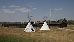
154:Reconstructed buildings at the site of Fort Caspar
834:at the Wyoming State Historic Preservation Office
496:reconstructed log buildings, including a wooden
1118:List of National Historic Landmarks in Wyoming
383:In July 1865, accompanied by survivors of the
859:
750:Life of George Bent: Written From His Letters
418:Among those leading the Indian warriors were
8:
1182:Buildings and structures in Casper, Wyoming
504:host a historical reenactment at the site.
995:Casper Motor Company-Natrona Motor Company
866:
852:
844:
536:"Fort Caspar (U.S. National Park Service)"
394:Late that night a detachment of 14 men of
148:
260:as a trading post and toll bridge on the
137:U.S. National Register of Historic Places
106:Learn how and when to remove this message
1137:1865 establishments in Dakota Territory
1000:Chicago and Northwestern Railroad Depot
975:Bridger Immigrant Road-Waltman Crossing
640:
638:
636:
591:
589:
587:
585:
513:
1187:Tourist attractions in Casper, Wyoming
937:South Wolcott Street Historic District
566:
564:
396:Company I, 3rd U.S. Volunteer Infantry
120:
522:Official State Highway Map of Wyoming
7:
990:Casper Fire Department Station No. 1
875:National Register of Historic Places
294:Fort Caspar Museum and Historic Site
290:National Register of Historic Places
44:adding citations to reliable sources
1147:Military and war museums in Wyoming
365:Battle of the Platte Bridge Station
1167:Museums in Natrona County, Wyoming
14:
129:Fort Caspar and Boundary Increase
1172:Pre-statehood history of Wyoming
908:
778:. University of Nebraska Press.
752:. University of Oklahoma Press.
733:. University of Nebraska Press.
346:operated a station at the site.
20:
1025:Grant Street Grocery and Market
305:several local points where the
31:needs additional citations for
239:August 12, 1971; July 19, 1976
223:
1:
1010:Consolidated Royalty Building
960:Archeological Site No. 48NA83
268:to protect emigrants and the
118:United States historic place
1045:Natrona County High School
887:National Historic Landmarks
430:, the half Cheyenne son of
400:11th Ohio Volunteer Cavalry
373:Reconstructed Platte Bridge
313:wagon train to present-day
248:was a military post of the
1208:
1040:Midwest Oil Company Hotel
942:TA Ranch Historic District
376:
1108:
1085:Stone Ranch Stage Station
1060:Ohio Oil Company Building
906:
770:Utley, Robert M. (1967).
222:NRHP reference
159:
147:
143:
134:
127:
123:
1015:DUX Bessemer Bend Bridge
919:Other historic districts
570:Hyde (1968), pp. 212-222
272:line against raids from
1005:Church of Saint Anthony
985:Casper Federal Building
879:Natrona County, Wyoming
707:Brown (1963), pp. 40-41
698:Hyde (1968), pp.220-222
680:Brown (1963), pp. 39-40
662:Brown (1963), pp. 36-38
621:Brown (1963), pp. 35-36
379:Battle of Platte Bridge
1080:Split Rock, Twin Peaks
1050:North Casper Clubhouse
729:The Galvanized Yankees
491:Restoration and Museum
422:and the famed warrior
374:
198:42.83667°N 106.37111°W
1177:Pony Express stations
793:Soule, Doris (2006).
596:Soule, Doris (2006).
372:
266:Platte Bridge Station
1055:Odd Fellows Building
927:Casper Army Air Base
725:Brown, Dee (1985) .
716:Utley (1967), p. 322
644:Utley (1967), p. 320
203:42.83667; -106.37111
40:improve this article
1020:Elks Lodge No. 1353
980:Casper Buffalo Trap
689:Brown (1963), p. 40
671:Brown (1963), p. 38
653:Hyde (1968), p. 216
630:Brown (1963), p. 37
579:Brown (1963), p. 36
404:11th Kansas Cavalry
385:Sand Creek Massacre
288:, is listed in the
194: /
838:"Bent-Hyde Papers"
830:2011-06-15 at the
799:Dec 1996 Wild West
602:Dec 1996 Wild West
375:
340:Nebraska Territory
258:North Platte River
250:United States Army
167:14 Fort Caspar Rd.
1124:
1123:
895:Independence Rock
785:978-0-8032-9550-6
282:Wyoming Boulevard
243:
242:
116:
115:
108:
90:
1199:
1142:California Trail
1100:Tribune Building
1075:Roosevelt School
952:Other properties
912:
868:
861:
854:
845:
809:
807:
806:
801:. historynet.com
789:
777:
763:
744:
732:
717:
714:
708:
705:
699:
696:
690:
687:
681:
678:
672:
669:
663:
660:
654:
651:
645:
642:
631:
628:
622:
619:
613:
612:
610:
609:
604:. historynet.com
593:
580:
577:
571:
568:
559:
556:
550:
549:
547:
546:
532:
526:
525:
518:
485:Douglas, Wyoming
225:
209:
208:
206:
205:
204:
199:
195:
192:
191:
190:
187:
152:
121:
111:
104:
100:
97:
91:
89:
48:
24:
16:
1207:
1206:
1202:
1201:
1200:
1198:
1197:
1196:
1127:
1126:
1125:
1120:
1104:
946:
913:
904:
881:
872:
832:Wayback Machine
816:
804:
802:
792:
786:
769:
760:
747:
741:
724:
721:
720:
715:
711:
706:
702:
697:
693:
688:
684:
679:
675:
670:
666:
661:
657:
652:
648:
643:
634:
629:
625:
620:
616:
607:
605:
595:
594:
583:
578:
574:
569:
562:
557:
553:
544:
542:
534:
533:
529:
520:
519:
515:
510:
502:3rd US Infantry
493:
477:
469:Collins' father
381:
367:
321:commissioned a
302:
286:Casper, Wyoming
252:in present-day
202:
200:
196:
193:
188:
185:
183:
181:
180:
170:Casper, Wyoming
168:
155:
139:
130:
119:
112:
101:
95:
92:
49:
47:
37:
25:
12:
11:
5:
1205:
1203:
1195:
1194:
1189:
1184:
1179:
1174:
1169:
1164:
1159:
1154:
1149:
1144:
1139:
1129:
1128:
1122:
1121:
1109:
1106:
1105:
1103:
1102:
1097:
1095:Townsend Hotel
1092:
1087:
1082:
1077:
1072:
1070:Rialto Theater
1067:
1065:Pathfinder Dam
1062:
1057:
1052:
1047:
1042:
1037:
1035:Masonic Temple
1032:
1027:
1022:
1017:
1012:
1007:
1002:
997:
992:
987:
982:
977:
972:
967:
965:Big Horn Hotel
962:
956:
954:
948:
947:
945:
944:
939:
934:
929:
923:
921:
915:
914:
907:
905:
903:
902:
897:
891:
889:
883:
882:
873:
871:
870:
863:
856:
848:
842:
841:
835:
822:
815:
814:External links
812:
811:
810:
790:
784:
767:
764:
758:
745:
739:
719:
718:
709:
700:
691:
682:
673:
664:
655:
646:
632:
623:
614:
581:
572:
560:
551:
527:
512:
511:
509:
506:
492:
489:
481:Fort Fetterman
476:
473:
452:Spencer rifles
415:remount detail
366:
363:
307:Emigrant Trail
301:
298:
241:
240:
237:
233:
232:
226:
219:
218:
215:
211:
210:
178:
174:
173:
165:
161:
160:
157:
156:
153:
145:
144:
141:
140:
135:
132:
131:
128:
125:
124:
117:
114:
113:
28:
26:
19:
13:
10:
9:
6:
4:
3:
2:
1204:
1193:
1190:
1188:
1185:
1183:
1180:
1178:
1175:
1173:
1170:
1168:
1165:
1163:
1160:
1158:
1155:
1153:
1150:
1148:
1145:
1143:
1140:
1138:
1135:
1134:
1132:
1119:
1115:
1112:
1107:
1101:
1098:
1096:
1093:
1091:
1088:
1086:
1083:
1081:
1078:
1076:
1073:
1071:
1068:
1066:
1063:
1061:
1058:
1056:
1053:
1051:
1048:
1046:
1043:
1041:
1038:
1036:
1033:
1031:
1030:Martin's Cove
1028:
1026:
1023:
1021:
1018:
1016:
1013:
1011:
1008:
1006:
1003:
1001:
998:
996:
993:
991:
988:
986:
983:
981:
978:
976:
973:
971:
968:
966:
963:
961:
958:
957:
955:
953:
949:
943:
940:
938:
935:
933:
930:
928:
925:
924:
922:
920:
916:
911:
901:
900:Tom Sun Ranch
898:
896:
893:
892:
890:
888:
884:
880:
876:
869:
864:
862:
857:
855:
850:
849:
846:
839:
836:
833:
829:
826:
823:
821:
820:Official site
818:
817:
813:
800:
796:
791:
787:
781:
776:
775:
768:
765:
761:
759:0-8061-1577-7
755:
751:
746:
742:
740:0-8032-6075-X
736:
731:
730:
723:
722:
713:
710:
704:
701:
695:
692:
686:
683:
677:
674:
668:
665:
659:
656:
650:
647:
641:
639:
637:
633:
627:
624:
618:
615:
603:
599:
592:
590:
588:
586:
582:
576:
573:
567:
565:
561:
555:
552:
541:
537:
531:
528:
523:
517:
514:
507:
505:
503:
499:
490:
488:
486:
482:
474:
472:
470:
466:
460:
458:
453:
447:
443:
439:
435:
433:
429:
425:
421:
416:
412:
407:
405:
401:
397:
392:
390:
386:
380:
371:
364:
362:
358:
356:
352:
347:
345:
341:
335:
332:
328:
324:
320:
319:Brigham Young
316:
312:
308:
299:
297:
295:
291:
287:
283:
279:
275:
271:
267:
263:
259:
255:
251:
247:
238:
236:Added to NRHP
234:
230:
227:
220:
217:Louis Guinard
216:
212:
207:
179:
175:
171:
166:
162:
158:
151:
146:
142:
138:
133:
126:
122:
110:
107:
99:
96:February 2009
88:
85:
81:
78:
74:
71:
67:
64:
60:
57: –
56:
55:"Fort Caspar"
52:
51:Find sources:
45:
41:
35:
34:
29:This article
27:
23:
18:
17:
1157:Oregon Trail
1152:Mormon Trail
1110:
970:Bishop House
931:
803:. Retrieved
798:
773:
749:
728:
712:
703:
694:
685:
676:
667:
658:
649:
626:
617:
606:. Retrieved
601:
575:
554:
543:. Retrieved
539:
530:
521:
516:
494:
478:
467:named after
461:
448:
444:
440:
436:
432:William Bent
408:
393:
389:Colorado War
382:
359:
348:
344:Pony Express
336:
303:
293:
265:
262:Oregon Trail
245:
244:
102:
93:
83:
76:
69:
62:
50:
38:Please help
33:verification
30:
1090:Teapot Rock
932:Fort Caspar
825:Fort Caspar
540:www.nps.gov
475:Abandonment
428:George Bent
246:Fort Caspar
201: /
189:106°22′16″W
177:Coordinates
1131:Categories
805:2012-01-09
608:2012-01-09
545:2021-05-07
508:References
424:Roman Nose
377:See also:
327:cottonwood
231:; 76002282
186:42°50′12″N
66:newspapers
1111:See also:
420:Red Cloud
270:telegraph
214:Architect
828:Archived
498:stockade
465:Colorado
457:Shoshone
411:reveille
355:Cheyenne
278:Cheyenne
229:71000887
164:Location
329:dugout
300:History
254:Wyoming
80:scholar
782:
756:
737:
409:After
351:Lakota
331:canoes
311:Mormon
274:Lakota
82:
75:
68:
61:
53:
323:ferry
172:82604
87:JSTOR
73:books
1116:and
780:ISBN
754:ISBN
735:ISBN
353:and
315:Utah
276:and
59:news
877:in
483:at
284:in
224:No.
42:by
1133::
797:.
635:^
600:.
584:^
563:^
538:.
487:.
471:.
426:.
317:,
296:.
867:e
860:t
853:v
808:.
788:.
762:.
743:.
611:.
548:.
109:)
103:(
98:)
94:(
84:·
77:·
70:·
63:·
36:.
Text is available under the Creative Commons Attribution-ShareAlike License. Additional terms may apply.