227:
251:
239:
119:
215:
153:
22:
202:
was in operation, the discharge of the Black Power Plant was treated by either a
Sanitary Waste Treatment (SWT) plant or on Industrial Waste Treatment (IWT) Plant. Treated discharge from these plants, meeting all state and federal regulations and requirements, went into the Creek. Since the plant's
164:
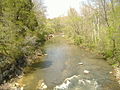
cliffs, and the region is noted for its karst sinkholes, hidden waterfalls, and small caves. Due to the damming of the Ohio River, much of the creek is of the same elevation as the river. In fact, the creek sometimes appears to be flowing upstream when in fact rising waters from the Ohio push into
149:; similar to how Eighteen Mile Island, Twelve Mile Island, and Six Mile Island got their names. It is navigable for 2.9 miles (4.7 km) from the Ohio River. It is a State Heritage Program Site and a popular canoe trail.
165:
the creek. Further upstream from the river, the creek is sometimes only a foot or two deep, which is why historically mills that used the creek had to use dams to keep a constant flow to run them.
378:
432:
250:
427:
39:
275:
238:
226:
280:
214:
105:
86:
58:
160:
The creek was formed when glaciated water flowed through the unglaciated stream valley that is now the creek. It is lined by
437:
43:
65:
417:
199:
185:
343:
189:
72:
422:
314:
270:
54:
299:
32:
257:
134:
138:
184:
Indian tribe resided here. Many local mills used
Fourteen Mile Creek for power, most especially
79:
181:
146:
118:
318:
192:
411:
310:
U.S. Geological Survey. National
Hydrography Dataset high-resolution flowline data.
152:
331:
Tunnel Mill: the story of an historical grist mill and an historic Boy Scout camp
166:
21:
300:
U.S. Geological Survey
Geographic Names Information System: Fourteenmile Creek
142:
393:
380:
367:
347:
161:
311:
170:
174:
15:
133:
on federal maps, is a 22.7-mile-long (36.5 km) creek in
195:
was situated where the creek and the Ohio River meet.
180:
The creek has seen much history. It is known that the
46:. Unsourced material may be challenged and removed.
156:Downstream from the bridge of Tunnel Mill Road
8:
244:Remains of the Rose Island suspension bridge
220:Upstream from the bridge of Tunnel Mill Road
145:is 14 miles (23 km) upstream from the
141:. It is so named because its mouth on the
106:Learn how and when to remove this message
151:
117:
292:
210:
177:are the most common fish on the creek.
203:demise, this is no longer a concern.
7:
44:adding citations to reliable sources
14:
281:Geography of Louisville, Kentucky
276:Devil's Backbone (rock formation)
249:
237:
225:
213:
20:
433:Rivers of Clark County, Indiana
31:needs additional citations for
333:by Gary D. Purlee (2005), pg 9
1:
428:Tributaries of the Ohio River
200:Indiana Army Ammunition Plant
454:
271:List of rivers of Indiana
198:During the time that the
321:, accessed May 19, 2011
232:Upstream from the mouth
258:Charlestown State Park
157:
123:
438:Waterfalls of Indiana
394:38.42340°N 85.62080°W
155:
135:Clark County, Indiana
121:
55:"Fourteen Mile Creek"
418:Charlestown, Indiana
40:improve this article
399:38.42340; -85.62080
390: /
127:Fourteen Mile Creek
317:2012-03-29 at the
158:
131:Fourteenmile Creek
124:
122:Mouth of the Creek
423:Rivers of Indiana
256:Waterfront along
147:Falls of the Ohio
116:
115:
108:
90:
445:
405:
404:
402:
401:
400:
395:
391:
388:
387:
386:
383:
370:
365:
359:
358:
356:
355:
346:. Archived from
340:
334:
328:
322:
312:The National Map
308:
302:
297:
253:
241:
229:
217:
111:
104:
100:
97:
91:
89:
48:
24:
16:
453:
452:
448:
447:
446:
444:
443:
442:
408:
407:
398:
396:
392:
389:
384:
381:
379:
377:
376:
374:
373:
366:
362:
353:
351:
342:
341:
337:
329:
325:
319:Wayback Machine
309:
305:
298:
294:
289:
267:
260:
254:
245:
242:
233:
230:
221:
218:
209:
188:. The popular
112:
101:
95:
92:
49:
47:
37:
25:
12:
11:
5:
451:
449:
441:
440:
435:
430:
425:
420:
410:
409:
372:
371:
360:
335:
323:
303:
291:
290:
288:
285:
284:
283:
278:
273:
266:
263:
262:
261:
255:
248:
246:
243:
236:
234:
231:
224:
222:
219:
212:
208:
205:
193:amusement park
114:
113:
28:
26:
19:
13:
10:
9:
6:
4:
3:
2:
450:
439:
436:
434:
431:
429:
426:
424:
421:
419:
416:
415:
413:
406:
403:
369:
364:
361:
350:on 2006-09-03
349:
345:
339:
336:
332:
327:
324:
320:
316:
313:
307:
304:
301:
296:
293:
286:
282:
279:
277:
274:
272:
269:
268:
264:
259:
252:
247:
240:
235:
228:
223:
216:
211:
206:
204:
201:
196:
194:
191:
187:
183:
178:
176:
172:
168:
163:
154:
150:
148:
144:
140:
136:
132:
128:
120:
110:
107:
99:
88:
85:
81:
78:
74:
71:
67:
64:
60:
57: –
56:
52:
51:Find sources:
45:
41:
35:
34:
29:This article
27:
23:
18:
17:
375:
363:
352:. Retrieved
348:the original
338:
330:
326:
306:
295:
197:
179:
159:
130:
126:
125:
102:
93:
83:
76:
69:
62:
50:
38:Please help
33:verification
30:
397: /
344:"NRC: Home"
190:Rose Island
186:Tunnel Mill
139:Charlestown
137:, close to
129:, shown as
412:Categories
385:85°37′15″W
382:38°25′24″N
354:2006-09-03
287:References
143:Ohio River
66:newspapers
368:NRC: Home
182:Talligewi
162:limestone
96:July 2020
315:Archived
265:See also
171:bluegill
207:Gallery
175:catfish
80:scholar
82:
75:
68:
61:
53:
87:JSTOR
73:books
173:and
167:Bass
59:news
42:by
414::
169:,
357:.
109:)
103:(
98:)
94:(
84:·
77:·
70:·
63:·
36:.
Text is available under the Creative Commons Attribution-ShareAlike License. Additional terms may apply.