187:(FSK). This allows the GPS measurement data to be transmitted and received on legacy VHF sonobuoy receiver equipment. A drifting array of twelve or more GIBs would be deployed in a concentric circular array approximately 7 nm in diameter. Weapon strikes within the array emitted acoustic signatures that were captured by the GIBs and transmitted up to the orbiting aircraft. Post-mission the GPS and acoustic data from the GIBs would be combined to determine an absolute coordinate for the impact location in
43:
200:
158:-equipped sonobuoys that are either drifting or moored. GIBs may be used in conjunction with an active underwater device (such as a pinger equipped torpedo), or with a passive acoustic sound source (such as an inert bomb striking the surface of the water). Typically the sound source or impact event is tracked or localized using a
162:(TOA) technique. Typically several GIBs are deployed over a given area of operation; with the total number determined by the size of the test area and the accuracy of the results desired. Different methods of GPS positioning may be used for positioning the array of GIBs, with accuracies of cm to meter level in realtime possible.
209:
203:
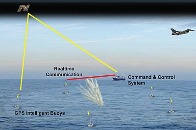
Figure 1: An array of GIBs positioned around a test area to provide weapon impact coordinates from weapon testing or training. Upon striking the water, acoustic signatures are captured and processed by each GIB, and relayed to the shipboard or a land based command and control system for realtime
231:
Inert weapon releases from military aircraft strike the surface of the water within the array, emitting an acoustic signature that is captured by each of the GIBs. Each GIB determines the precise time of the received signal and transmits this time to the deployment ship in near real time. A
165:
Buoys are manufactured by the French company ACSA-underwater-GPS (subsidiary of the ALCEN group). Three off-the shelf products are available from the small portable GIB-Lite system to the large torpedo tracking GIB-FT, and including the medium-size, medium-range GIB-Plus system.
232:
command and control system located on the deployment and recovery ship combines the GPS data and acoustic timing information to triangulate the impact location and determine the exact impact time in near realtime. Several methods may be used, the most common being a
236:(TDOA) least-squares solution algorithm. Post-mission data processing is performed to further refine the results, with two-dimensional positioning accuracies of 1 to 2 meters and impact timing accuracies of 1-2 milliseconds demonstrated.
294:
Saunders, J., and
Cardoza, M. "Preliminary Results from a GPS-Based Portable Impact Location System", Proceedings of the Institute of Navigation's Satellite Division Meeting, ION GPS-95, Palm Springs, California, 12-15 September,
219:
The system concept (Figure 1) utilizes an array eight to ten GIBs (Figure 2) moored in a 2 km by 2 km array. In the case of the TARGT GIB, the GPS and RF antennas are located on top of the sensor and the
174:
Use of GIBs for underwater tracking and weapon scoring have been in use by the Navy since the early to mid 1990s. Early GIBs were created for broad ocean area weapons testing by modifying conventional Navy
306:
Kayser, J.R., Cardoza, M.A., et al., "Weapon
Scoring Results from a GPS Acoustic Weapons Test and Training System", Institute of Navigation National Technical Meeting, San Diego, CA, 24-26 January 2005
216:
GIB type systems have been developed for a variety of specialized applications. An illustrative use of GIBs for underwater positioning is the TARGT weapon scoring and training system
179:
with small OEM-grade GPS receivers and deploying them from a helicopter or from P-3 Orion aircraft. The GPS data captured by the GIB was modulated over the analog
151:
345:
126:
64:
107:
305:
60:
79:
86:
233:
273:
93:
53:
184:
75:
228:, is located on the bottom. The device is approximately 6 ft tall and weighs 35 lbs.
340:
317:
Cardoza, M.A., Kayser, J.R., & Wade, B. "Offshore
Scoring of Precision Guided Munitions"
316:
159:
100:
334:
17:
321:
293:
42:
225:
221:
176:
208:
199:
31:
188:
207:
198:
180:
155:
36:
195:
Example of underwater acoustic-based weapon scoring
67:. Unsourced material may be challenged and removed.
283:. Academy of Positioning Marine and Bathymetry.
154:devices where the transducers are installed on
8:
127:Learn how and when to remove this message
274:"Underwater Acoustic Positioning System"
152:long-baseline (LBL) acoustic positioning
30:For broader coverage of this topic, see
244:
212:Figure 2: Photograph of the TARGT GIB
7:
268:
266:
264:
262:
260:
65:adding citations to reliable sources
25:
41:
52:needs additional citations for
1:
27:Acoustic positioning devices
183:acoustic data stream using
170:History and examples of use
362:
234:time difference of arrival
29:
346:Global Positioning System
224:, or underwater acoustic
150:) are a type of inverted
325:April 2006, pages 32-39
213:
205:
185:frequency-shift keying
281:Scientific Manifest 2
211:
202:
18:GPS intelligent buoys
144:GPS intelligent buoy
61:improve this article
214:
206:
137:
136:
129:
111:
16:(Redirected from
353:
326:
314:
308:
303:
297:
291:
285:
284:
278:
270:
255:
249:
132:
125:
121:
118:
112:
110:
69:
45:
37:
21:
361:
360:
356:
355:
354:
352:
351:
350:
331:
330:
329:
315:
311:
304:
300:
292:
288:
276:
272:
271:
258:
252:
246:
242:
197:
172:
160:time of arrival
133:
122:
116:
113:
70:
68:
58:
46:
35:
28:
23:
22:
15:
12:
11:
5:
359:
357:
349:
348:
343:
333:
332:
328:
327:
309:
298:
286:
256:
250:
243:
241:
238:
196:
193:
171:
168:
135:
134:
76:"GPS sonobuoy"
49:
47:
40:
26:
24:
14:
13:
10:
9:
6:
4:
3:
2:
358:
347:
344:
342:
339:
338:
336:
324:
323:
318:
313:
310:
307:
302:
299:
296:
290:
287:
282:
275:
269:
267:
265:
263:
261:
257:
254:
251:
248:
245:
239:
237:
235:
229:
227:
223:
217:
210:
201:
194:
192:
191:coordinates.
190:
186:
182:
178:
169:
167:
163:
161:
157:
153:
149:
145:
141:
131:
128:
120:
117:February 2010
109:
106:
102:
99:
95:
92:
88:
85:
81:
78: –
77:
73:
72:Find sources:
66:
62:
56:
55:
50:This article
48:
44:
39:
38:
33:
19:
320:
312:
301:
289:
280:
253:
247:
230:
218:
215:
173:
164:
147:
143:
140:GPS sonobuoy
139:
138:
123:
114:
104:
97:
90:
83:
71:
59:Please help
54:verification
51:
322:Inside GNSS
335:Categories
240:References
226:transducer
222:hydrophone
204:processing
87:newspapers
177:sonobuoys
32:GPS buoy
341:Buoyage
101:scholar
189:WGS 84
103:
96:
89:
82:
74:
277:(PDF)
108:JSTOR
94:books
295:1995
80:news
181:VHF
156:GPS
148:GIB
142:or
63:by
337::
319:,
279:.
259:^
146:(
130:)
124:(
119:)
115:(
105:·
98:·
91:·
84:·
57:.
34:.
20:)
Text is available under the Creative Commons Attribution-ShareAlike License. Additional terms may apply.