861:
58:
43:
754:
797:
108:
259:
499:, Gazaria Upazila had 34,760 households and a population of 157,988. Out of this population, 34,949 inhabitants (22.12%) were under 10 years of age. Gazaria had a literacy rate (age 7 and over) of 57.19%, compared to the national average of 51.8%, and a sex ratio of 1006 females per 1000 males. 6,559 (4.15%) lived in urban areas.
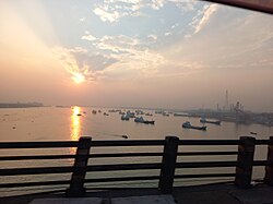
421:, covering a total area of 130.92 km. It is the Meghna River delta, which separates it from the district headquarters of Munshiganj. Two bridges connect it with the mainland: the Meghna Bridge in the west, and the Meghna-Gomotee Bridge in the east. The Kajali river flows through the district.
374:
In May 1971, the
Pakistani army entered Gazaria by river. A raid on the village of Goshairchar on 9 May killed more than four hundred people. The army proceeded to Bhaberchar where they also killed eleven sheltering in a ditch. Other villages in the area were attacked in the same raid.
860:
378:
Bangladeshi soldiers from
Gazaria fought at Bhabercha, Baluakand and Baushia under the leadership of Rafiqul Islam and interrupted communication along the highway by destroying the bridge at Bhaterchar in August 1971, obstructing the advancement of the Pakistani army.
785:
695:
518:: Baluakandi, Baushia, Gajaria, Guagachia, Hosendee, Imampur, Tengarchar, and Vaberchar. The union parishads are subdivided into 114 mauzas and 133 villages.
763:
1451:
778:
366:
The
Pakistan government established the Dhaka-Chittagong High way through the locality. Gazaria Thana was turned into an upazila in 1983.
651:
68:
42:
771:
57:
623:
688:
363:
during
British rule. Gazaria became the part of Munshiganj Thana in 1946 and the independent Gazaria Thana was established in 1954.
342:
573:
276:
960:
609:
584:
323:
280:
598:
295:
556:
526:
In 2001 Gazaria had a literacy rate of 32.7% (counting people over the age of 7), compared to national figures of 32.4%.
1117:
681:
302:
393:
1266:
269:
1223:
1041:
940:
309:
1347:
1175:
950:
845:
728:
187:
753:
1256:
1132:
1089:
968:
291:
132:
120:
897:
503:
496:
464:
33:
1430:
1309:
930:
892:
1294:
1200:
998:
360:
1319:
1180:
1157:
733:
704:
449:
356:
355:
Gazaria is mainly composed of alluvial land around the Meghna river. The locality became a part of
230:
137:
1327:
1289:
1238:
1127:
1109:
1076:
1046:
1021:
978:
907:
902:
840:
1357:
1337:
1299:
1251:
1213:
1208:
1190:
1185:
1142:
1051:
1031:
1006:
988:
983:
935:
877:
869:
743:
738:
655:
316:
1425:
1420:
1415:
1410:
1405:
1400:
1395:
1367:
1281:
1170:
1099:
1061:
1011:
973:
922:
912:
887:
723:
544:
218:
1390:
1385:
1380:
1332:
1304:
1271:
1228:
1147:
1137:
1084:
1036:
1016:
945:
830:
1375:
1352:
1261:
1246:
1218:
1094:
1066:
882:
822:
802:
515:
234:
125:
1445:
1342:
1122:
1056:
850:
835:
548:
48:
1026:
242:
258:
796:
238:
113:
408:
395:
382:
In 2011 the Local
Government constructed a memorial at Goshairchar, Gazaria.
83:
70:
178:
574:"Bangladesh Population and Housing Census 2011 Zila Report – Munshiganj"
226:
100:
673:
183:
199:
813:
245:
delta, 28 kilometres (17 mi) from the capital city of Dhaka.
767:
677:
252:
1366:
1318:
1280:
1237:
1199:
1156:
1108:
1075:
997:
959:
921:
868:
821:
711:
283:. Unsourced material may be challenged and removed.
194:
177:
169:
161:
156:
148:
143:
131:
119:
99:
21:
553:Banglapedia: National Encyclopedia of Bangladesh
779:
689:
8:
568:
566:
786:
772:
764:
696:
682:
674:
18:
343:Learn how and when to remove this message
599:"Community Tables: Munshiganj district"
535:
506:, Gazaria had a population of 128,368.
193:
176:
155:
142:
98:
63:
54:
39:
624:"District Statistics 2011: Munshiganj"
514:Gazaria Upazila is divided into eight
152:131.00 km (50.58 sq mi)
168:
160:
147:
130:
118:
7:
281:adding citations to reliable sources
434:Religions in Gazaria upazila (2011)
14:
859:
795:
752:
257:
106:
56:
41:
1452:Upazilas of Munshiganj District
631:Bangladesh Bureau of Statistics
610:Bangladesh Bureau of Statistics
585:Bangladesh Bureau of Statistics
268:needs additional citations for
390:Gazaria Upazila is located at
1:
652:"Population Census Wing, BBS"
557:Asiatic Society of Bangladesh
543:Rahman, AKM Habibur (2012).
16:Upazila in Dhaka, Bangladesh
173:1,200/km (3,100/sq mi)
1468:
857:
551:; Jamal, Ahmed A. (eds.).
809:
750:
486:
478:
473:
463:
458:
448:
443:
438:
433:
222:
64:
55:
40:
31:
241:. It is located on the
504:1991 Bangladesh census
497:2011 Bangladesh census
1201:Narayanganj District
999:Kishoreganj District
277:improve this article
225:) is one of the six
170: • Density
1320:Shariatpur District
1158:Munshiganj District
705:Munshiganj District
555:(Second ed.).
479:Other or not stated
409:23.5417°N 90.6083°E
405: /
370:War of Independence
233:in the Division of
231:Munshiganj District
84:23.5417°N 90.6083°E
80: /
47:Meghna Bridge near
1239:Narsingdi District
1110:Manikganj District
1077:Madaripur District
961:Gopalganj District
162: • Total
149: • Total
1439:
1438:
870:Faridpur District
761:
760:
545:"Gazaria Upazila"
502:According to the
495:According to the
491:
490:
353:
352:
345:
327:
292:"Gazaria Upazila"
212:
211:
1459:
1368:Tangail District
1282:Rajbari District
923:Gazipur District
863:
801:Upazilas of the
800:
799:
788:
781:
774:
765:
756:
698:
691:
684:
675:
668:
667:
665:
663:
654:. Archived from
648:
642:
641:
639:
637:
628:
620:
614:
613:
603:
595:
589:
588:
578:
570:
561:
560:
540:
431:
430:
420:
419:
417:
416:
415:
414:23.5417; 90.6083
410:
406:
403:
402:
401:
398:
348:
341:
337:
334:
328:
326:
285:
261:
253:
224:
208:
205:
203:
201:
112:
110:
109:
95:
94:
92:
91:
90:
89:23.5417; 90.6083
85:
81:
78:
77:
76:
73:
60:
45:
19:
1467:
1466:
1462:
1461:
1460:
1458:
1457:
1456:
1442:
1441:
1440:
1435:
1362:
1314:
1276:
1233:
1195:
1152:
1104:
1071:
993:
955:
917:
864:
855:
817:
805:
794:
792:
762:
757:
748:
707:
702:
672:
671:
661:
659:
650:
649:
645:
635:
633:
626:
622:
621:
617:
601:
597:
596:
592:
576:
572:
571:
564:
542:
541:
537:
532:
524:
516:union parishads
512:
493:
492:
484:
471:
456:
427:
413:
411:
407:
404:
399:
396:
394:
392:
391:
388:
372:
349:
338:
332:
329:
286:
284:
274:
262:
251:
215:Gazaria Upazila
198:
107:
105:
88:
86:
82:
79:
74:
71:
69:
67:
66:
51:
36:
27:
24:
17:
12:
11:
5:
1465:
1463:
1455:
1454:
1444:
1443:
1437:
1436:
1434:
1433:
1428:
1423:
1418:
1413:
1408:
1403:
1398:
1393:
1388:
1383:
1378:
1372:
1370:
1364:
1363:
1361:
1360:
1355:
1350:
1345:
1340:
1335:
1330:
1324:
1322:
1316:
1315:
1313:
1312:
1307:
1302:
1297:
1292:
1286:
1284:
1278:
1277:
1275:
1274:
1269:
1264:
1259:
1254:
1249:
1243:
1241:
1235:
1234:
1232:
1231:
1226:
1221:
1216:
1211:
1205:
1203:
1197:
1196:
1194:
1193:
1188:
1183:
1178:
1173:
1168:
1162:
1160:
1154:
1153:
1151:
1150:
1145:
1140:
1135:
1130:
1125:
1120:
1114:
1112:
1106:
1105:
1103:
1102:
1097:
1092:
1087:
1081:
1079:
1073:
1072:
1070:
1069:
1064:
1059:
1054:
1049:
1044:
1039:
1034:
1029:
1024:
1019:
1014:
1009:
1003:
1001:
995:
994:
992:
991:
986:
981:
976:
971:
965:
963:
957:
956:
954:
953:
948:
943:
938:
933:
927:
925:
919:
918:
916:
915:
910:
905:
900:
898:Faridpur Sadar
895:
890:
885:
880:
874:
872:
866:
865:
858:
856:
854:
853:
848:
843:
838:
833:
827:
825:
823:Dhaka District
819:
818:
811:Headquarters:
810:
807:
806:
803:Dhaka Division
793:
791:
790:
783:
776:
768:
759:
758:
751:
749:
747:
746:
741:
736:
731:
726:
721:
715:
713:
712:Upazila/Thana:
709:
708:
703:
701:
700:
693:
686:
678:
670:
669:
643:
615:
590:
562:
549:Islam, Sirajul
534:
533:
531:
528:
523:
520:
511:
510:Administration
508:
489:
488:
485:
482:
480:
476:
475:
472:
469:
467:
461:
460:
457:
454:
452:
446:
445:
442:
440:
436:
435:
429:
428:
426:
423:
387:
384:
371:
368:
361:Assam District
351:
350:
265:
263:
256:
250:
247:
210:
209:
196:
192:
191:
181:
175:
174:
171:
167:
166:
163:
159:
158:
154:
153:
150:
146:
145:
141:
140:
135:
129:
128:
123:
117:
116:
103:
97:
96:
62:
61:
53:
52:
46:
38:
37:
32:
29:
28:
25:
22:
15:
13:
10:
9:
6:
4:
3:
2:
1464:
1453:
1450:
1449:
1447:
1432:
1429:
1427:
1424:
1422:
1419:
1417:
1414:
1412:
1409:
1407:
1404:
1402:
1399:
1397:
1394:
1392:
1389:
1387:
1384:
1382:
1379:
1377:
1374:
1373:
1371:
1369:
1365:
1359:
1356:
1354:
1351:
1349:
1346:
1344:
1341:
1339:
1336:
1334:
1331:
1329:
1326:
1325:
1323:
1321:
1317:
1311:
1308:
1306:
1303:
1301:
1298:
1296:
1293:
1291:
1288:
1287:
1285:
1283:
1279:
1273:
1270:
1268:
1265:
1263:
1260:
1258:
1255:
1253:
1250:
1248:
1245:
1244:
1242:
1240:
1236:
1230:
1227:
1225:
1222:
1220:
1217:
1215:
1212:
1210:
1207:
1206:
1204:
1202:
1198:
1192:
1189:
1187:
1184:
1182:
1179:
1177:
1174:
1172:
1169:
1167:
1164:
1163:
1161:
1159:
1155:
1149:
1146:
1144:
1141:
1139:
1136:
1134:
1131:
1129:
1126:
1124:
1121:
1119:
1116:
1115:
1113:
1111:
1107:
1101:
1098:
1096:
1093:
1091:
1088:
1086:
1083:
1082:
1080:
1078:
1074:
1068:
1065:
1063:
1060:
1058:
1055:
1053:
1050:
1048:
1045:
1043:
1040:
1038:
1035:
1033:
1030:
1028:
1025:
1023:
1020:
1018:
1015:
1013:
1010:
1008:
1005:
1004:
1002:
1000:
996:
990:
987:
985:
982:
980:
977:
975:
972:
970:
967:
966:
964:
962:
958:
952:
949:
947:
944:
942:
939:
937:
934:
932:
929:
928:
926:
924:
920:
914:
911:
909:
906:
904:
901:
899:
896:
894:
893:Charbhadrasan
891:
889:
886:
884:
881:
879:
876:
875:
873:
871:
867:
862:
852:
849:
847:
844:
842:
839:
837:
834:
832:
829:
828:
826:
824:
820:
816:
815:
808:
804:
798:
789:
784:
782:
777:
775:
770:
769:
766:
755:
745:
742:
740:
737:
735:
732:
730:
727:
725:
722:
720:
717:
716:
714:
710:
706:
699:
694:
692:
687:
685:
680:
679:
676:
658:on 2005-03-27
657:
653:
647:
644:
632:
625:
619:
616:
611:
607:
600:
594:
591:
586:
582:
575:
569:
567:
563:
558:
554:
550:
546:
539:
536:
529:
527:
522:Literacy rate
521:
519:
517:
509:
507:
505:
500:
498:
481:
477:
468:
466:
462:
453:
451:
447:
441:
437:
432:
424:
422:
418:
385:
383:
380:
376:
369:
367:
364:
362:
358:
357:Tippara Thana
347:
344:
336:
325:
322:
318:
315:
311:
308:
304:
301:
297:
294: –
293:
289:
288:Find sources:
282:
278:
272:
271:
266:This article
264:
260:
255:
254:
248:
246:
244:
240:
236:
232:
228:
220:
216:
207:
197:
189:
185:
182:
180:
172:
164:
151:
139:
136:
134:
127:
124:
122:
115:
104:
102:
93:
65:Coordinates:
59:
50:
44:
35:
30:
20:
1295:Goalandaghat
1165:
812:
718:
662:November 10,
660:. Retrieved
656:the original
646:
634:. Retrieved
630:
618:
605:
593:
580:
552:
538:
525:
513:
501:
494:
425:Demographics
389:
381:
377:
373:
365:
354:
339:
330:
320:
313:
306:
299:
287:
275:Please help
270:verification
267:
243:Meghna river
214:
213:
1224:Narayanganj
1181:Sirajdikhan
1042:Kishoreganj
734:Sirajdikhan
412: /
202:.munshiganj
87: /
1348:Shariatpur
1328:Bhedarganj
1290:Baliakandi
1176:Munshiganj
1128:Harirampur
1047:Kuliarchar
1022:Hossainpur
979:Kotalipara
908:Nagarkanda
903:Madhukhali
841:Keraniganj
729:Munshiganj
606:bbs.gov.bd
581:bbs.gov.bd
530:References
400:90°36′30″E
397:23°32′30″N
359:under the
303:newspapers
239:Bangladesh
157:Population
138:Munshiganj
114:Bangladesh
75:90°36′30″E
72:23°32′30″N
1358:Shakhipur
1338:Gosairhat
1300:Kalukhali
1257:Narsingdi
1252:Monohardi
1214:Sonargaon
1209:Araihazar
1191:Tongibari
1186:Sreenagar
1143:Shivalaya
1133:Manikganj
1118:Daulatpur
1090:Madaripur
1052:Mithamain
1032:Karimganj
1007:Austagram
989:Tungipara
984:Muksudpur
969:Gopalganj
936:Kaliakair
878:Alfadanga
846:Nawabganj
744:Tongibari
739:Sreenagar
386:Geography
179:Time zone
1446:Category
1426:Sakhipur
1421:Nagarpur
1416:Mirzapur
1411:Dhanbari
1406:Madhupur
1401:Kalihati
1396:Gopalpur
1171:Lohaganj
1100:Shibchar
1062:Pakundia
1012:Bajitpur
974:Kashiani
941:Kaliganj
913:Sadarpur
888:Boalmari
724:Lohaganj
465:Hinduism
439:Religion
333:May 2016
227:upazilas
223:গজারিয়া
133:District
121:Division
26:গজারিয়া
1431:Tangail
1391:Ghatail
1386:Delduar
1381:Bhuapur
1333:Damudya
1310:Rajbari
1305:Pangsha
1272:Shibpur
1267:Raipura
1229:Rupganj
1166:Gazaria
1148:Singair
1138:Saturia
1085:Kalkini
1037:Katiadi
1017:Bhairab
951:Sreepur
946:Kapasia
931:Gazipur
831:Dhamrai
719:Gazaria
636:14 July
612:. 2011.
483:
470:
455:
444:Percent
317:scholar
249:History
219:Bengali
200:gajaria
195:Website
165:157,988
101:Country
49:Gazaria
34:Upazila
23:Gazaria
1376:Basail
1353:Zajira
1262:Palash
1247:Belabo
1219:Bandar
1095:Rajoir
1067:Tarail
883:Bhanga
459:96.77%
319:
312:
305:
298:
290:
111:
1343:Naria
1123:Ghior
1057:Nikli
851:Savar
836:Dohar
814:Dhaka
627:(PDF)
602:(PDF)
577:(PDF)
547:. In
487:0.03%
474:3.20%
450:Islam
324:JSTOR
310:books
235:Dhaka
184:UTC+6
126:Dhaka
1027:Itna
664:2006
638:2014
296:news
204:.gov
144:Area
279:by
229:of
206:.bd
188:BST
1448::
629:.
608:.
604:.
583:.
579:.
565:^
237:,
221::
787:e
780:t
773:v
697:e
690:t
683:v
666:.
640:.
587:.
559:.
346:)
340:(
335:)
331:(
321:·
314:·
307:·
300:·
273:.
217:(
190:)
186:(
Text is available under the Creative Commons Attribution-ShareAlike License. Additional terms may apply.