143:
36:
222:
Tables of erosion and accretion, started by G. O. Case and maintained by the government, showed that accretion in the early 1840s was followed by erosion in the late 1840s. By 1855, the great
Kingston Flood took place when the sea-dam, an earthen wall, was breached. It inundated the
230:
It was after this catastrophe that the sea wall between Fort
William Frederick and the Round House was started in 1858. Built principally by convict labor with granite from the Penal Settlement at Mazaruni (now
451:
288:
239:
committed to the construction of a continuous wall from Camp Street to Kitty. By 1882, the Sea Wall had been extended to reach as far as
329:
119:
53:
100:
283:
235:), the first section, which ran from Fort Groyne to Round House was completed by 1860. In 1874, the Public Works department of
72:
57:
407:
79:
252:
86:
46:
384:
68:
219:, known to be existing in 1792 north of the present Georgetown Seawall, were completely washed away by 1804.
216:
211:
Seawalls are necessary because of constant erosion of land by the sea. Historians note that two estates,
293:
240:
142:
232:
227:
ward of
Georgetown and washed away Camp House (the former residence for governors of the colony).
271:
192:
148:
321:
93:
212:
446:
325:
224:
259:. The shelter north of the bandstand, called the Koh-i-noor Shelter, was erected in 1903.
352:
314:
267:
263:
256:
236:
440:
195:. It protects settlements in the coastal areas of Guyana, most of which are below
17:
35:
422:
409:
200:
196:
262:
Serious flooding resulting from breaches in the sea wall took place at
184:
188:
163:
191:'s coastline, including all of the coastline in the capital city of
255:
was built with funds subscribed by the public as a memorial to
29:
169:
159:
60:. Unsourced material may be challenged and removed.
313:
346:
344:
8:
135:
378:
376:
141:
134:
120:Learn how and when to remove this message
353:"A brief history of flooding in Guyana"
304:
351:Kandasammy, Lloyd (16 February 2006).
289:Water supply and sanitation in Guyana
7:
58:adding citations to reliable sources
452:Buildings and structures in Guyana
25:
34:
320:. Bradt Travel Guides. p.
284:East Demerara Water Conservancy
45:needs additional citations for
383:Chin, Godfrey (17 July 2011).
316:Guyana: the Bradt Travel Guide
1:
385:"The romance of the Sea Wall"
243:and it was completed in 1892
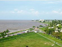
147:A section of the Sea Wall in
253:Georgetown Seawall Bandstand
468:
155:
140:
187:that runs along much of
27:280-mile wall in Guyana
423:6.825414°N 58.159106°W
294:2005 Georgetown flood
136:The Guyanese Sea Wall
428:6.825414; -58.159106
312:Smock, Kirk (2008).
54:improve this article
419: /
336:sea wall 280 miles.
137:
69:"Sea Wall, Guyana"
18:Georgetown Seawall
177:
176:
130:
129:
122:
104:
16:(Redirected from
459:
434:
433:
431:
430:
429:
424:
420:
417:
416:
415:
412:
400:
399:
397:
395:
380:
371:
370:
368:
366:
357:
348:
339:
338:
319:
309:
270:in 1959, and at
145:
138:
125:
118:
114:
111:
105:
103:
62:
38:
30:
21:
467:
466:
462:
461:
460:
458:
457:
456:
437:
436:
427:
425:
421:
418:
413:
410:
408:
406:
405:
403:
393:
391:
382:
381:
374:
364:
362:
355:
350:
349:
342:
332:
311:
310:
306:
302:
280:
249:
247:Further history
233:Mazaruni Prison
209:
151:
132:
126:
115:
109:
106:
63:
61:
51:
39:
28:
23:
22:
15:
12:
11:
5:
465:
463:
455:
454:
449:
439:
438:
402:
401:
372:
356:(Archive copy)
340:
330:
303:
301:
298:
297:
296:
291:
286:
279:
276:
257:Queen Victoria
248:
245:
237:British Guiana
208:
205:
183:is a 280-mile
175:
174:
171:
167:
166:
161:
157:
156:
153:
152:
146:
128:
127:
110:September 2012
42:
40:
33:
26:
24:
14:
13:
10:
9:
6:
4:
3:
2:
464:
453:
450:
448:
445:
444:
442:
435:
432:
390:
389:Stabroek News
386:
379:
377:
373:
361:
360:Stabroek News
354:
347:
345:
341:
337:
333:
331:9781841622231
327:
323:
318:
317:
308:
305:
299:
295:
292:
290:
287:
285:
282:
281:
277:
275:
273:
269:
265:
260:
258:
254:
246:
244:
242:
241:Unity Village
238:
234:
228:
226:
220:
218:
214:
206:
204:
202:
198:
194:
190:
186:
182:
172:
168:
165:
162:
158:
154:
150:
144:
139:
133:
124:
121:
113:
102:
99:
95:
92:
88:
85:
81:
78:
74:
71: –
70:
66:
65:Find sources:
59:
55:
49:
48:
43:This article
41:
37:
32:
31:
19:
404:
394:15 September
392:. Retrieved
388:
365:15 September
363:. Retrieved
359:
335:
315:
307:
266:in 1955, at
261:
251:In 1903 the
250:
229:
221:
210:
207:Construction
180:
178:
131:
116:
107:
97:
90:
83:
76:
64:
52:Please help
47:verification
44:
426: /
272:Bladen Hall
217:Sandy Point
441:Categories
414:58°09′33″W
300:References
193:Georgetown
149:Georgetown
80:newspapers
411:6°49′31″N
274:in 1961.
213:Kierfield
201:high tide
197:sea level
173:280 miles
447:Seawalls
278:See also
225:Kingston
181:Sea Wall
160:Location
185:seawall
94:scholar
328:
268:Buxton
264:Enmore
189:Guyana
170:Length
164:Guyana
96:
89:
82:
75:
67:
101:JSTOR
87:books
396:2012
367:2012
326:ISBN
215:and
179:The
73:news
322:114
199:at
56:by
443::
387:.
375:^
358:.
343:^
334:.
324:.
203:.
398:.
369:.
123:)
117:(
112:)
108:(
98:·
91:·
84:·
77:·
50:.
20:)
Text is available under the Creative Commons Attribution-ShareAlike License. Additional terms may apply.