301:
59:
34:
287:
66:
41:
322:
213:
in the north to the Gilf Kebir in the south. Its south western part is covered by the Silica Glass area, which is scattered with fragments of pure glass, formed about 30 million years ago due to the explosion of a meteorite or comet.
217:
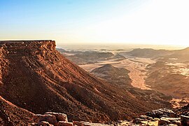
The Gilf Kebir is a plateau, furrowed by immense north trending wadis. The area was settled by a population already at the beginning of the
Neolithic area some 9000 years ago during the
244:
The Gebel
Uweinat, situated about 150 km south of the Gilf Kebir and most of which lies in Sudanese and Libyan territories, is another massif important for its abundant rock art.
432:
300:
608:
58:
33:
102:
380:
425:
349:
286:
174:. Established in 2007, it has a surface area of 48533 km, equal to about 5% of Egypt's territory. GKNP is delimited to the west by
404:
603:
441:
418:
613:
364:
522:
517:
557:
567:
512:
507:
467:
552:
502:
482:
547:
457:
328:
248:
222:
577:
449:
167:
86:
462:
582:
218:
497:
238:
195:
400:
311:
252:
396:
230:
203:
368:
321:
264:
234:
155:
226:
191:
597:
562:
487:
272:
268:
163:
361:
247:
The presence of humans in the 20th century CE is evidenced by the remains of the
542:
537:
527:
492:
532:
472:
210:
199:
117:
104:
190:
The park consists of three different ecosystems: the southern ranges of the
182:. At present there are no human settlements or facilities inside the GKNP.
410:
307:
221:, leaving splendid rock paintings and engravings of uncertain age in the
209:
The Great Sand Sea is a large complex of sand dunes extending from the
477:
179:
175:
171:
90:
414:
381:
A report on the expedition to the Gilf Kebir national Park
362:
Rudolph Kuper: Archaeology of the Gilf Kebir
National Park
293:
View from the Gilf Kebir ridge to the south into wadi Sura
263:
The GKNP contains important desert-adapted flora (trees:
448:
141:
133:
96:
82:
21:
399:, Gilf Kebir national park (Egypt Pocket Guide),
65:
40:
16:National park in New Valley Governorate, Egypt
426:
251:WWII-camps such as trucks and an airfield at
8:
433:
419:
411:
18:
350:Features of the Gilf Kebir National Park
202:plateau and the Egyptian portion of the
342:
282:
137:48,533 km (18,739 sq mi)
166:located in the remote and hyper-arid
7:
81:
609:Protected areas established in 2007
159:
14:
320:
299:
285:
64:
57:
39:
32:
271:, Fagonia thebaica) and fauna (
140:
186:Ecosystems and cultural values
1:
241:on its southern foothills.
630:
568:White Desert National Park
26:
573:Gilf Kebir National Park
152:Gilf Kebir National Park
22:Gilf Kebir National Park
604:National parks of Egypt
548:Wadi Degla Protectorate
442:National Parks of Egypt
249:Long Range Desert Group
614:New Valley Governorate
168:New Valley Governorate
87:New Valley Governorate
383:Retrieved 2020/04/20.
371:Retrieved 2020/04/20.
352:Retrieved 2020/04/20.
118:23.75000°N 25.83333°E
225:and in the caves of
219:African humid period
178:and to the south by
239:Magharet el Kantara
114: /
367:2021-01-24 at the
160:محمية الجلف الكبير
123:23.75000; 25.83333
73:Show map of Africa
591:
590:
523:Saluga and Ghazal
312:Eight Bells Hills
253:Eight Bells Hills
196:Silica glass area
149:
148:
48:Show map of Egypt
621:
508:Petrified Forest
435:
428:
421:
412:
397:Alberto Siliotti
384:
378:
372:
359:
353:
347:
324:
303:
289:
204:Gabal El Uweinat
161:
129:
128:
126:
125:
124:
119:
115:
112:
111:
110:
107:
74:
68:
67:
61:
49:
43:
42:
36:
19:
629:
628:
624:
623:
622:
620:
619:
618:
594:
593:
592:
587:
473:El Hassana Dome
468:Ashtum El Gamil
444:
439:
393:
391:Further reading
388:
387:
379:
375:
369:Wayback Machine
360:
356:
348:
344:
339:
332:
331:
325:
316:
315:
304:
295:
294:
290:
281:
265:Acacia raddiana
261:
259:Flora and fauna
188:
122:
120:
116:
113:
108:
105:
103:
101:
100:
78:
77:
76:
75:
72:
71:
70:
69:
52:
51:
50:
47:
46:
45:
44:
17:
12:
11:
5:
627:
625:
617:
616:
611:
606:
596:
595:
589:
588:
586:
585:
580:
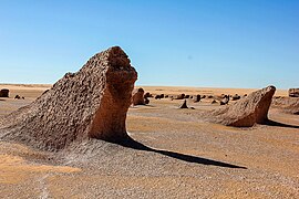
575:
570:
565:
560:
555:
553:Wadi El Assuti
550:
545:
540:
535:
530:
525:
520:
515:
510:
505:
500:
495:
490:
485:
480:
475:
470:
465:
460:
454:
452:
446:
445:
440:
438:
437:
430:
423:
415:
409:
408:
405:978-8887177848
392:
389:
386:
385:
373:
354:
341:
340:
338:
335:
334:
333:
327:
326:
319:
317:
314:WWII air field
306:
305:
298:
296:
292:
291:
284:
280:
277:
260:
257:
194:including the
192:Great Sand Sea
187:
184:
147:
146:
143:
139:
138:
135:
131:
130:
98:
94:
93:
84:
80:
79:
63:
62:
56:
55:
54:
53:
38:
37:
31:
30:
29:
28:
27:
24:
23:
15:
13:
10:
9:
6:
4:
3:
2:
626:
615:
612:
610:
607:
605:
602:
601:
599:
584:
581:
579:
576:
574:
571:
569:
566:
564:
563:Wadi El Rayan
561:
559:
558:Wadi El Gamal
556:
554:
551:
549:
546:
544:
541:
539:
536:
534:
531:
529:
526:
524:
521:
519:
518:St. Catherine
516:
514:
511:
509:
506:
504:
501:
499:
496:
494:
491:
489:
488:Lake Burullus
486:
484:
481:
479:
476:
474:
471:
469:
466:
464:
461:
459:
456:
455:
453:
451:
450:Protectorates
447:
443:
436:
431:
429:
424:
422:
417:
416:
413:
406:
402:
398:
395:
394:
390:
382:
377:
374:
370:
366:
363:
358:
355:
351:
346:
343:
336:
330:
323:
318:
313:
309:
302:
297:
288:
283:
278:
276:
274:
273:Barbary Sheep
270:
269:Zilla spinosa
266:
258:
256:
254:
250:
245:
242:
240:
236:
232:
228:
224:
220:
215:
212:
207:
205:
201:
198:, the proper
197:
193:
185:
183:
181:
177:
173:
169:
165:
164:national park
157:
153:
144:
136:
132:
127:
99:
95:
92:
88:
85:
60:
35:
25:
20:
583:Black Desert
572:
513:Ras Muhammad
503:Nile Islands
376:
357:
345:
262:
246:
243:
216:
208:
189:
151:
150:
543:Wadi Allaqi
528:Sannur Cave
142:Established
121: /
97:Coordinates
598:Categories
533:Siwa Oasis
493:Lake Qarun
483:Gabal Elba
337:References
329:Wadi Hamra
267:, shrubs:
223:wadi Hamra
211:Siwa oasis
200:Gilf Kebir
478:El Omayed
458:Abu Galum
310:near the
109:25°50′0″E
106:23°45′0″N
365:Archived
308:Yardangs
231:Swimmers
206:massif.
154:(GKNP) (
83:Location
578:Zaranik
279:Gallery
235:Archers
162:) is a
463:Ahrash
403:
227:Beasts
156:Arabic
498:Nabaq
180:Sudan
176:Libya
172:Egypt
91:Egypt
538:Taba
401:ISBN
237:and
145:2007
134:Area
275:).
600::
255:.
233:,
229:,
170:,
158::
89:,
434:e
427:t
420:v
407:.
Text is available under the Creative Commons Attribution-ShareAlike License. Additional terms may apply.