268:
58:
86:
41:
93:
65:
475:
253:
The park received
International Dark Sky Park designation by The International Dark-Sky Association in March, 2021. Night photography and stargazing are popular activities because there is little light pollution due to its remoteness.
238:
forced the river to carve incised meanders over 1,000 feet (300 m) deep as the surrounding landscape slowly rose in elevation. Eroded by water, wind, frost, and gravity, this is a classic location for observing
664:
623:
1123:
1153:
250:
with picnic tables are scattered back from the edge of the cliff, and vault toilets are available. Campers are advised to bring their own water, food, and other necessary gear.
274:
1357:
512:
827:
369:
842:
1352:
1113:
542:
799:
85:
57:
267:
970:
136:
533:
1028:
1020:
649:
1277:
804:
776:
631:
505:
454:
1367:
1282:
1272:
1190:
654:
521:
710:
1103:
735:
1098:
613:
603:
580:
725:
325:
1262:
771:
608:
498:
975:
860:
697:
687:
479:
227:
985:
865:
781:
588:
30:
1362:
1133:
1083:
1078:
895:
890:
822:
745:
299:
1297:
1267:
1225:
1163:
1073:
965:
915:
875:
814:
598:
1108:
990:
880:
855:
832:
791:
593:
565:
555:
1257:
940:
885:
560:
1347:
1245:
1195:
1178:
1056:
900:
850:
763:
753:
730:
720:
641:
421:
925:
395:
995:
920:
1322:
1317:
1312:
1200:
1088:
950:
935:
930:
905:
705:
1302:
1230:
1205:
1000:
910:
870:
715:
116:
370:"IDA has awarded International Dark Sky Park Designations to Fremont Indian and Goosenecks State Parks"
1158:
1148:
1138:
1128:
1005:
980:
960:
945:
550:
235:
1215:
1210:
1292:
1220:
1143:
1047:
682:
570:
40:
955:
450:
444:
351:
231:
1307:
1118:
672:
240:
203:
1235:
1093:
1068:
1010:
1341:
258:
124:
329:
1033:
677:
230:. The park is located near the southern border of the state a short distance from
1168:
303:
485:
215:
151:
138:
490:
474:
247:
261:, a few miles to the northwest, provides access to the San Juan River.
223:
525:
219:
120:
494:
396:"Goosenecks State Park [Activities, Info & More]"
257:
There are no developed hiking trails in the park, but the
246:
Goosenecks State Park is largely undeveloped. Primitive
1244:
1177:
1055:
1046:
1019:
841:
813:
790:
762:
744:
696:
663:
640:
622:
579:
541:
532:
446:
Hiking the
Southwest's Geology: Four Corners Region
199:
191:
183:
175:
167:
130:
112:
23:
506:
92:
64:
8:
1052:
538:
513:
499:
491:
294:
292:
20:
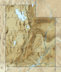
100:Goosenecks State Park (the United States)
72:Location of Goosenecks State Park in Utah
1358:Protected areas of San Juan County, Utah
449:. The Mountaineers Books. p. 123.
326:"Goosenecks State Park: About the Park"
288:
7:
111:
1353:Protected areas established in 1962
374:International Dark-Sky Association
328:. Utah State Parks. Archived from
14:
1114:Historic Union Pacific Rail Trail
16:State park in Utah, United States
772:Bear River Migratory Bird Refuge
473:
266:
91:
84:
63:
56:
39:
33:V (protected landscape/seascape)
182:
234:. Millions of years ago, the
1:
971:Paria Canyon-Vermilion Cliffs
302:. Utah.com LC. Archived from
103:Show map of the United States
45:Aerial view of the Goosenecks
277:Panoramic view from overlook
179:4,500 ft (1,400 m)
1368:1962 establishments in Utah
792:National Conservation Areas
443:Hopkins, Ralph Lee (2002).
1386:
1278:Escalante Petrified Forest
833:Jurassic National Monument
828:Grand Staircase–Escalante
764:National Wildlife Refuges
642:National Recreation Areas
195:55,660 (in 2022)
50:
38:
28:
1104:Fred Hayes at Starvation
754:Desert Biosphere Reserve
665:National Historic Trails
624:National Historic Parks
424:. Americansouthwest.net
422:"Goosenecks State Park"
300:"Goosenecks State Park"
1226:Territorial Statehouse
1021:Wild and Scenic Rivers
815:BLM National Monuments
581:NPS National Monuments
352:"Park Visitation Data"
171:10 acres (4.0 ha)
152:37.17472°N 109.92694°W
1263:Coral Pink Sand Dunes
1124:Jordan River OHV Park
843:U.S. Wilderness Areas
486:Goosenecks State Park
480:Goosenecks State Park
222:, overlooking a deep
218:in the U.S. state of
212:Goosenecks State Park
24:Goosenecks State Park
976:Pine Valley Mountain
861:Beaver Dam Mountains
746:Forest Service areas
482:at Wikimedia Commons
306:on February 24, 2009
157:37.17472; -109.92694
1363:State parks of Utah
1006:Wellsville Mountain
866:Black Ridge Canyons
736:Uinta–Wasatch–Cache
148: /
1283:Frontier Homestead
1273:Edge of the Cedars
1335:
1334:
1331:
1330:
1042:
1041:
896:Cottonwood Forest
891:Cottonwood Canyon
478:Media related to
456:978-0-89886-856-2
400:www.visitutah.com
332:on March 16, 2011
232:Mexican Hat, Utah
209:
208:
1375:
1298:Kodachrome Basin
1268:Dead Horse Point
1251:
1184:
1164:Wasatch Mountain
1154:Utah Field House
1062:
1053:
966:Mount Timpanogos
916:Deep Creek North
876:Box-Death Hollow
698:National Forests
539:
515:
508:
501:
492:
477:
461:
460:
440:
434:
433:
431:
429:
420:Crossley, John.
417:
411:
410:
408:
406:
392:
386:
385:
383:
381:
376:. March 25, 2021
366:
360:
359:
356:Utah State Parks
348:
342:
341:
339:
337:
322:
316:
315:
313:
311:
296:
270:
241:incised meanders
204:Utah State Parks
163:
162:
160:
159:
158:
153:
149:
146:
145:
144:
141:
104:
95:
94:
88:
76:
75:Show map of Utah
67:
66:
60:
43:
21:
1385:
1384:
1378:
1377:
1376:
1374:
1373:
1372:
1348:IUCN Category V
1338:
1337:
1336:
1327:
1250:Southern Region
1249:
1248:
1240:
1182:
1181:
1173:
1109:Great Salt Lake
1069:Antelope Island
1061:Northern Region
1060:
1059:
1038:
1015:
991:Slaughter Creek
881:Canaan Mountain
856:Beartrap Canyon
837:
809:
800:Beaver Dam Wash
786:
758:
740:
711:Caribou–Targhee
692:
659:
636:
618:
614:Timpanogos Cave
604:Natural Bridges
575:
528:
522:Protected areas
519:
470:
465:
464:
457:
442:
441:
437:
427:
425:
419:
418:
414:
404:
402:
394:
393:
389:
379:
377:
368:
367:
363:
358:. July 6, 2023.
350:
349:
345:
335:
333:
324:
323:
319:
309:
307:
298:
297:
290:
285:
280:
279:
278:
276:
271:
236:Monument Upwarp
156:
154:
150:
147:
142:
139:
137:
135:
134:
108:
107:
106:
105:
102:
101:
98:
97:
96:
79:
78:
77:
74:
73:
70:
69:
68:
46:
34:
17:
12:
11:
5:
1383:
1382:
1379:
1371:
1370:
1365:
1360:
1355:
1350:
1340:
1339:
1333:
1332:
1329:
1328:
1326:
1325:
1320:
1315:
1310:
1305:
1300:
1295:
1290:
1285:
1280:
1275:
1270:
1265:
1260:
1254:
1252:
1242:
1241:
1239:
1238:
1233:
1228:
1223:
1218:
1213:
1208:
1203:
1198:
1193:
1191:Fremont Indian
1187:
1185:
1183:Central Region
1175:
1174:
1172:
1171:
1166:
1161:
1156:
1151:
1146:
1141:
1136:
1131:
1126:
1121:
1116:
1111:
1106:
1101:
1096:
1091:
1086:
1081:
1076:
1071:
1065:
1063:
1050:
1044:
1043:
1040:
1039:
1037:
1036:
1031:
1025:
1023:
1017:
1016:
1014:
1013:
1008:
1003:
998:
993:
988:
983:
978:
973:
968:
963:
958:
953:
948:
943:
941:LaVerkin Creek
938:
933:
928:
923:
918:
913:
908:
903:
898:
893:
888:
886:Cedar Mountain
883:
878:
873:
868:
863:
858:
853:
847:
845:
839:
838:
836:
835:
830:
825:
819:
817:
811:
810:
808:
807:
802:
796:
794:
788:
787:
785:
784:
779:
774:
768:
766:
760:
759:
757:
756:
750:
748:
742:
741:
739:
738:
733:
728:
723:
718:
713:
708:
702:
700:
694:
693:
691:
690:
685:
680:
678:Mormon Pioneer
675:
669:
667:
661:
660:
658:
657:
652:
646:
644:
638:
637:
635:
634:
628:
626:
620:
619:
617:
616:
611:
609:Rainbow Bridge
606:
601:
596:
591:
585:
583:
577:
576:
574:
573:
568:
563:
558:
553:
547:
545:
543:National Parks
536:
530:
529:
520:
518:
517:
510:
503:
495:
489:
488:
483:
469:
468:External links
466:
463:
462:
455:
435:
412:
387:
361:
343:
317:
287:
286:
284:
281:
273:
272:
265:
264:
263:
228:San Juan River
207:
206:
201:
197:
196:
193:
189:
188:
185:
181:
180:
177:
173:
172:
169:
165:
164:
132:
128:
127:
114:
110:
109:
99:
90:
89:
83:
82:
81:
80:
71:
62:
61:
55:
54:
53:
52:
51:
48:
47:
44:
36:
35:
29:
26:
25:
15:
13:
10:
9:
6:
4:
3:
2:
1381:
1380:
1369:
1366:
1364:
1361:
1359:
1356:
1354:
1351:
1349:
1346:
1345:
1343:
1324:
1321:
1319:
1316:
1314:
1311:
1309:
1306:
1304:
1301:
1299:
1296:
1294:
1291:
1289:
1286:
1284:
1281:
1279:
1276:
1274:
1271:
1269:
1266:
1264:
1261:
1259:
1256:
1255:
1253:
1247:
1243:
1237:
1234:
1232:
1229:
1227:
1224:
1222:
1219:
1217:
1214:
1212:
1209:
1207:
1204:
1202:
1199:
1197:
1196:Goblin Valley
1194:
1192:
1189:
1188:
1186:
1180:
1176:
1170:
1167:
1165:
1162:
1160:
1157:
1155:
1152:
1150:
1147:
1145:
1142:
1140:
1137:
1135:
1132:
1130:
1127:
1125:
1122:
1120:
1117:
1115:
1112:
1110:
1107:
1105:
1102:
1100:
1097:
1095:
1092:
1090:
1087:
1085:
1082:
1080:
1077:
1075:
1072:
1070:
1067:
1066:
1064:
1058:
1054:
1051:
1049:
1045:
1035:
1032:
1030:
1027:
1026:
1024:
1022:
1018:
1012:
1009:
1007:
1004:
1002:
999:
997:
994:
992:
989:
987:
986:Red Mountains
984:
982:
979:
977:
974:
972:
969:
967:
964:
962:
961:Mount Olympus
959:
957:
954:
952:
949:
947:
944:
942:
939:
937:
934:
932:
929:
927:
924:
922:
919:
917:
914:
912:
909:
907:
904:
902:
901:Cougar Canyon
899:
897:
894:
892:
889:
887:
884:
882:
879:
877:
874:
872:
869:
867:
864:
862:
859:
857:
854:
852:
851:Ashdown Gorge
849:
848:
846:
844:
840:
834:
831:
829:
826:
824:
821:
820:
818:
816:
812:
806:
803:
801:
798:
797:
795:
793:
789:
783:
780:
778:
775:
773:
770:
769:
767:
765:
761:
755:
752:
751:
749:
747:
743:
737:
734:
732:
729:
727:
724:
722:
719:
717:
714:
712:
709:
707:
704:
703:
701:
699:
695:
689:
686:
684:
681:
679:
676:
674:
671:
670:
668:
666:
662:
656:
653:
651:
650:Flaming Gorge
648:
647:
645:
643:
639:
633:
630:
629:
627:
625:
621:
615:
612:
610:
607:
605:
602:
600:
597:
595:
592:
590:
587:
586:
584:
582:
578:
572:
569:
567:
564:
562:
559:
557:
554:
552:
549:
548:
546:
544:
540:
537:
535:
531:
527:
523:
516:
511:
509:
504:
502:
497:
496:
493:
487:
484:
481:
476:
472:
471:
467:
458:
452:
448:
447:
439:
436:
423:
416:
413:
401:
397:
391:
388:
375:
371:
365:
362:
357:
353:
347:
344:
331:
327:
321:
318:
305:
301:
295:
293:
289:
282:
275:
269:
262:
260:
259:Honaker Trail
255:
251:
249:
244:
242:
237:
233:
229:
225:
221:
217:
213:
205:
202:
198:
194:
190:
186:
178:
174:
170:
166:
161:
133:
129:
126:
125:United States
122:
118:
115:
87:
59:
49:
42:
37:
32:
31:IUCN category
27:
22:
19:
1287:
1034:Virgin River
996:Taylor Creek
921:Deseret Peak
777:Fish Springs
726:Manti–La Sal
683:Pony Express
632:Golden Spike
589:Cedar Breaks
566:Capitol Reef
556:Bryce Canyon
445:
438:
426:. Retrieved
415:
403:. Retrieved
399:
390:
378:. Retrieved
373:
364:
355:
346:
334:. Retrieved
330:the original
320:
308:. Retrieved
304:the original
256:
252:
245:
211:
210:
18:
1323:Snow Canyon
1318:Sand Hollow
1313:Quail Creek
1303:Otter Creek
1246:State Parks
1201:Green River
1179:State Parks
1169:Willard Bay
1099:Flight Park
1089:East Canyon
1057:State Parks
1029:Green River
951:Mount Naomi
936:High Uintas
931:Goose Creek
906:Dark Canyon
688:Old Spanish
655:Glen Canyon
561:Canyonlands
428:January 18,
405:November 2,
380:November 2,
336:February 5,
310:February 5,
184:Established
155: /
143:109°55′37″W
131:Coordinates
1342:Categories
1288:Goosenecks
1231:Utahraptor
1206:Huntington
1134:Lost Creek
1129:Jordanelle
1084:Deer Creek
1079:Camp Floyd
1001:Twin Peaks
956:Mount Nebo
926:Doc's Pass
911:Deep Creek
871:Blackridge
823:Bears Ears
805:Red Cliffs
673:California
283:References
216:state park
140:37°10′29″N
1159:Utah Lake
1149:Steinaker
1139:Red Fleet
1074:Bear Lake
981:Red Butte
946:Lone Peak
599:Hovenweep
248:campsites
176:Elevation
1221:Scofield
1216:Palisade
1211:Millsite
1144:Rockport
731:Sawtooth
721:Fishlake
594:Dinosaur
200:Operator
192:Visitors
117:San Juan
113:Location
1293:Gunlock
1258:Anasazi
534:Federal
226:of the
224:meander
706:Ashley
551:Arches
453:
1308:Piute
1119:Hyrum
1048:State
782:Ouray
716:Dixie
214:is a
1236:Yuba
1094:Echo
1011:Zion
571:Zion
526:Utah
451:ISBN
430:2010
407:2021
382:2021
338:2011
312:2011
220:Utah
187:1962
168:Area
121:Utah
524:of
1344::
398:.
372:.
354:.
291:^
243:.
123:,
119:,
514:e
507:t
500:v
459:.
432:.
409:.
384:.
340:.
314:.
Text is available under the Creative Commons Attribution-ShareAlike License. Additional terms may apply.