59:
66:
1252:
43:
602:
58:
1288:
454:
1293:
421:
1097:
1074:
484:
409:
607:
528:
551:
358:
900:
1079:
622:
612:
475:
447:
1221:
1059:
1008:
988:
710:
112:
574:
993:
463:
1283:
1028:
1013:
349:
198:, the Wilderness was created by the "White Pine County Conservation, Recreation and Development Act of 2006" and is administered by the
1117:
1069:
1064:
1018:
915:
855:
800:
546:
440:
314:
1145:
1231:
850:
506:
488:
1180:
1185:
1122:
1112:
1023:
945:
660:
584:
1226:
1107:
1003:
998:
566:
354:
403:
1140:
1102:
730:
199:
163:
28:
237:
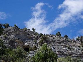
Eroding natural limestone in the Cherry Creek Range has created
Goshute Cave, an underground network of caves popular with
790:
496:
319:
665:
555:
517:
1175:
965:
955:
920:
910:
860:
815:
750:
695:
690:
685:
805:
305:
Popular recreational activities in
Goshute Canyon Wilderness include camping, hiking, hunting, fishing, and caving.
1170:
1150:
1132:
1089:
1051:
930:
925:
840:
740:
725:
700:
594:
512:
250:
705:
1278:
1195:
960:
935:
895:
885:
810:
765:
755:
523:
500:
179:
82:
1200:
1190:
980:
950:
820:
785:
770:
715:
675:
670:
645:
538:
940:
344:
415:
387:
890:
880:
875:
870:
830:
760:
640:
630:
1205:
1165:
865:
845:
825:
795:
745:
680:
835:
650:
226:
422:"Scientists Voice Their Overwhelming Support for Wilderness Designations in White Pine County, Nevada"
1155:
1042:
905:
780:
579:
775:
720:
635:
655:
191:
1160:
970:
214:
175:
32:
324:
195:
100:
1272:
1256:
258:
90:
229:
trees crowd the moist drainages along the creeks that flow through the
Wilderness.
427:
249:
Various species of wildlife can be found in
Goshute Canyon Wilderness, including
290:
286:
218:
206:
183:
127:
114:
432:
254:
42:
282:
210:
467:
294:
270:
262:
187:
86:
274:
238:
222:
278:
436:
266:
205:
Vegetation in the
Wilderness consists primarily of thick
1214:
1131:
1088:
1050:
1041:
979:
621:
593:
565:
537:
483:
474:
159:
151:
143:
106:
96:
78:
21:
603:Black Rock Desert–High Rock Canyon Emigrant Trails
47:Goshute Cave entrance in Goshute Canyon Wilderness
65:
404:Goshute Canyon Wilderness Study Area fact sheet
448:
8:
1289:Protected areas of White Pine County, Nevada
1047:
480:
455:
441:
433:
18:
1294:Bureau of Land Management areas in Nevada
383:
381:
379:
377:
375:
359:United States Department of the Interior
16:Wilderness area in Nevada, United States
336:
213:stands at the lower elevations, while
7:
77:
350:Geographic Names Information System
315:List of wilderness areas in Nevada
221:thrive in the higher elevations.
174:is a 42,544-acre (17,217 ha)
14:
1250:
64:
57:
41:
355:United States Geological Survey
150:
95:
418:- Friends of Nevada Wilderness
390:- Friends of Nevada Wilderness
200:U.S. Bureau of Land Management
164:U.S. Bureau of Land Management
1:
320:List of U.S. Wilderness Areas
147:42,544 acres (17,217 ha)
595:National Conservation Areas
529:Tule Springs Fossil Beds NM
345:"Goshute Canyon Wilderness"
1310:
1284:Wilderness areas of Nevada
711:East Fork High Rock Canyon
251:Bonneville cutthroat trout
1244:
1075:Old Las Vegas Mormon Fort
981:National Wildlife Refuges
539:National Recreation Areas
428:Goshute Canyon Wilderness
424:by the Wilderness Society
410:Goshute Canyon Wilderness
388:Goshute Canyon Wilderness
172:Goshute Canyon Wilderness
52:
40:
26:
22:Goshute Canyon Wilderness
1098:Big Bend of the Colorado
901:Santa Rosa–Paradise Peak
916:South Jackson Mountains
856:North Jackson Mountains
801:Little High Rock Canyon
851:North Black Rock Range
416:Bristlecone Wilderness
1186:Spring Mountain Ranch
966:Worthington Mountains
946:Wee Thump Joshua Tree
194:north of the town of
128:40.0520°N 114.8513°W
1080:Ward Charcoal Ovens
806:Meadow Valley Range
731:Fortification Range
241:in the Wilderness.
160:Governing body
124: /
1222:Belmont Courthouse
1146:Berlin–Ichthyosaur
926:South Pahroc Range
791:La Madre Mountains
507:Basin and Range NM
192:Cherry Creek Range
190:. Located in the
133:40.0520; -114.8513
1266:
1265:
1257:Nevada portal
1240:
1239:
1181:Lake Tahoe–Nevada
1060:Elgin Schoolhouse
1037:
1036:
706:Delamar Mountains
666:Black Rock Desert
180:White Pine County
169:
168:
155:December 20, 2006
97:Nearest city
83:White Pine County
1301:
1279:IUCN Category Ib
1255:
1254:
1253:
1090:Recreation Areas
1048:
961:White Rock Range
956:White Pine Range
921:South McCullough
911:South Egan Range
886:Rainbow Mountain
861:North McCullough
811:Mormon Mountains
751:High Rock Canyon
696:Currant Mountain
691:Clover Mountains
686:Calico Mountains
623:Wilderness Areas
585:Lake Tahoe Basin
575:Humboldt–Toiyabe
567:National Forests
552:Spring Mountains
481:
457:
450:
443:
434:
391:
385:
370:
369:
367:
365:
341:
139:
138:
136:
135:
134:
129:
125:
122:
121:
120:
117:
68:
67:
61:
45:
19:
1309:
1308:
1304:
1303:
1302:
1300:
1299:
1298:
1269:
1268:
1267:
1262:
1251:
1249:
1236:
1210:
1171:Ice Age Fossils
1151:Cathedral Gorge
1127:
1084:
1033:
975:
931:Spirit Mountain
841:Muddy Mountains
741:Government Peak
726:Far South Egans
617:
608:Red Rock Canyon
589:
561:
533:
513:Death Valley NP
470:
464:Protected areas
461:
400:
395:
394:
386:
373:
363:
361:
343:
342:
338:
333:
311:
303:
247:
235:
176:wilderness area
132:
130:
126:
123:
118:
115:
113:
111:
110:
74:
73:
72:
71:
70:
69:
48:
36:
33:wilderness area
17:
12:
11:
5:
1307:
1305:
1297:
1296:
1291:
1286:
1281:
1271:
1270:
1264:
1263:
1261:
1260:
1245:
1242:
1241:
1238:
1237:
1235:
1234:
1229:
1224:
1218:
1216:
1212:
1211:
1209:
1208:
1203:
1198:
1196:Valley of Fire
1193:
1188:
1183:
1178:
1173:
1168:
1163:
1158:
1153:
1148:
1143:
1137:
1135:
1129:
1128:
1126:
1125:
1120:
1115:
1110:
1105:
1100:
1094:
1092:
1086:
1085:
1083:
1082:
1077:
1072:
1070:Mormon Station
1067:
1065:Fort Churchill
1062:
1056:
1054:
1052:Historic Parks
1045:
1039:
1038:
1035:
1034:
1032:
1031:
1026:
1021:
1016:
1011:
1006:
1001:
996:
991:
985:
983:
977:
976:
974:
973:
968:
963:
958:
953:
948:
943:
938:
936:Table Mountain
933:
928:
923:
918:
913:
908:
903:
898:
896:Ruby Mountains
893:
888:
883:
878:
873:
868:
863:
858:
853:
848:
843:
838:
833:
828:
823:
818:
813:
808:
803:
798:
793:
788:
783:
778:
773:
768:
766:Highland Ridge
763:
758:
756:High Rock Lake
753:
748:
743:
738:
736:Goshute Canyon
733:
728:
723:
718:
713:
708:
703:
698:
693:
688:
683:
678:
673:
668:
663:
658:
653:
648:
643:
638:
633:
627:
625:
619:
618:
616:
615:
610:
605:
599:
597:
591:
590:
588:
587:
582:
577:
571:
569:
563:
562:
560:
559:
549:
543:
541:
535:
534:
532:
531:
526:
524:Great Basin NP
521:
515:
510:
504:
497:Avi Kwa Ame NM
493:
491:
485:National Parks
478:
472:
471:
462:
460:
459:
452:
445:
437:
431:
430:
425:
419:
413:
407:
399:
398:External links
396:
393:
392:
371:
335:
334:
332:
329:
328:
327:
325:Wilderness Act
322:
317:
310:
307:
302:
299:
246:
243:
234:
231:
167:
166:
161:
157:
156:
153:
149:
148:
145:
141:
140:
108:
104:
103:
101:McGill, Nevada
98:
94:
93:
80:
76:
75:
63:
62:
56:
55:
54:
53:
50:
49:
46:
38:
37:
27:
24:
23:
15:
13:
10:
9:
6:
4:
3:
2:
1306:
1295:
1292:
1290:
1287:
1285:
1282:
1280:
1277:
1276:
1274:
1259:
1258:
1247:
1246:
1243:
1233:
1230:
1228:
1225:
1223:
1220:
1219:
1217:
1213:
1207:
1204:
1202:
1199:
1197:
1194:
1192:
1191:Spring Valley
1189:
1187:
1184:
1182:
1179:
1177:
1174:
1172:
1169:
1167:
1164:
1162:
1159:
1157:
1154:
1152:
1149:
1147:
1144:
1142:
1139:
1138:
1136:
1134:
1130:
1124:
1121:
1119:
1116:
1114:
1111:
1109:
1106:
1104:
1101:
1099:
1096:
1095:
1093:
1091:
1087:
1081:
1078:
1076:
1073:
1071:
1068:
1066:
1063:
1061:
1058:
1057:
1055:
1053:
1049:
1046:
1044:
1040:
1030:
1027:
1025:
1022:
1020:
1017:
1015:
1012:
1010:
1007:
1005:
1002:
1000:
997:
995:
992:
990:
987:
986:
984:
982:
978:
972:
969:
967:
964:
962:
959:
957:
954:
952:
951:Weepah Spring
949:
947:
944:
942:
941:Tunnel Spring
939:
937:
934:
932:
929:
927:
924:
922:
919:
917:
914:
912:
909:
907:
904:
902:
899:
897:
894:
892:
889:
887:
884:
882:
879:
877:
874:
872:
869:
867:
864:
862:
859:
857:
854:
852:
849:
847:
844:
842:
839:
837:
834:
832:
829:
827:
824:
822:
819:
817:
816:Mt Charleston
814:
812:
809:
807:
804:
802:
799:
797:
794:
792:
789:
787:
786:Jumbo Springs
784:
782:
779:
777:
774:
772:
771:Ireteba Peaks
769:
767:
764:
762:
759:
757:
754:
752:
749:
747:
744:
742:
739:
737:
734:
732:
729:
727:
724:
722:
719:
717:
716:East Humboldt
714:
712:
709:
707:
704:
702:
699:
697:
694:
692:
689:
687:
684:
682:
679:
677:
676:Bridge Canyon
674:
672:
671:Boundary Peak
669:
667:
664:
662:
659:
657:
654:
652:
649:
647:
646:Bald Mountain
644:
642:
639:
637:
634:
632:
629:
628:
626:
624:
620:
614:
611:
609:
606:
604:
601:
600:
598:
596:
592:
586:
583:
581:
578:
576:
573:
572:
570:
568:
564:
557:
553:
550:
548:
545:
544:
542:
540:
536:
530:
527:
525:
522:
519:
518:Gold Butte NM
516:
514:
511:
508:
505:
502:
498:
495:
494:
492:
490:
486:
482:
479:
477:
473:
469:
465:
458:
453:
451:
446:
444:
439:
438:
435:
429:
426:
423:
420:
417:
414:
411:
408:
405:
402:
401:
397:
389:
384:
382:
380:
378:
376:
372:
360:
356:
352:
351:
346:
340:
337:
330:
326:
323:
321:
318:
316:
313:
312:
308:
306:
300:
298:
296:
292:
288:
284:
280:
276:
272:
268:
264:
260:
259:mountain lion
256:
252:
244:
242:
240:
232:
230:
228:
224:
220:
216:
212:
208:
203:
201:
197:
193:
189:
185:
181:
177:
173:
165:
162:
158:
154:
146:
142:
137:
109:
105:
102:
99:
92:
91:United States
88:
84:
81:
60:
51:
44:
39:
34:
30:
29:IUCN category
25:
20:
1248:
1176:Kershaw–Ryan
1118:Walker River
1009:Moapa Valley
989:Anaho Island
891:Red Mountain
881:Quinn Canyon
876:Pinto Valley
871:Parsnip Peak
761:High Schells
735:
701:Death Valley
661:Black Canyon
641:Arrow Canyon
631:Alta Toquima
613:Sloan Canyon
412:- Nevada BLM
406:- Nevada BLM
362:. Retrieved
348:
339:
304:
248:
236:
233:Goshute Cave
204:
178:in northern
171:
170:
1232:Walker Lake
1206:Washoe Lake
1166:Echo Canyon
994:Ash Meadows
866:Pahute Peak
846:Nellis Wash
796:Lime Canyon
746:Grant Range
681:Bristlecone
291:sage grouse
287:blue grouse
219:limber pine
215:bristlecone
207:pinyon pine
152:Established
131: /
119:114°51′05″W
107:Coordinates
1273:Categories
1227:Floyd Lamb
1201:Van Sickle
1141:Beaver Dam
1123:Wild Horse
1113:South Fork
1029:Stillwater
1014:Pahranagat
821:Mt Grafton
651:Becky Peak
331:References
301:Recreation
227:cottonwood
184:U.S. state
116:40°03′07″N
1156:Cave Lake
1108:Rye Patch
1019:Ruby Lake
906:Shellback
831:Mt Moriah
781:Jimbilnan
656:Big Rocks
547:Lake Mead
489:Monuments
364:August 9,
255:mule deer
1215:Previous
1103:Lahontan
826:Mt Irish
776:Jarbidge
721:Eldorado
636:Arc Dome
309:See also
245:Wildlife
79:Location
1024:Sheldon
836:Mt Rose
476:Federal
283:kestrel
211:juniper
182:in the
1161:Dayton
1004:Fallon
999:Desert
971:Wovoka
468:Nevada
295:marmot
293:, and
271:falcon
263:bobcat
239:cavers
196:Mcgill
188:Nevada
87:Nevada
1133:Other
1043:State
520:(BLM)
509:(BLM)
275:eagle
223:Aspen
580:Inyo
556:USFS
487:and
366:2015
279:hawk
225:and
217:and
209:and
144:Area
31:Ib (
501:BLM
466:of
267:owl
186:of
1275::
374:^
357:,
353:.
347:.
297:.
289:,
285:,
281:,
277:,
273:,
269:,
265:,
261:,
257:,
253:,
202:.
89:,
85:,
558:)
554:(
503:)
499:(
456:e
449:t
442:v
368:.
35:)
Text is available under the Creative Commons Attribution-ShareAlike License. Additional terms may apply.