93:
57:
691:
38:
702:
511:
712:
100:
64:
361:" 'The lake flanked by grass'; 'gres', 'mere'. Early spellings in 'Grys-', 'Gris(s)-' might suggest ON 'griss' 'young pig' as 1st el., but the weight of the evidence points to OE/ON 'gres' 'grass', with the modern form influenced by Standard English....The medial '-s(s)e-' may, as suggested by
341:. In 2017 this island was bequeathed to the National Trust. This gift has particular significance to the National Trust, as the organisation was founded in response to the sale of the same island to a private bidder in 1893. Canon
570:
327:
92:
746:
563:
307:
The lake is 1680 yd (1540 m) long and 700 yd (640 m) wide, covering an area of 0.24 mi² (0.62 km²). It has a maximum depth of 70 ft (21m) and an elevation above
56:
556:
439:
153:
736:
705:
579:
539:
270:
741:
485:
350:
440:"National Trust finally owns Lake District island which inspired its creation, after generous donor leaves it in her will"
365:
in DEPN, point to ON 'gres-saer' 'grass-lake' as the original name.". Plus the element "'mere' OE, ModE 'lake, 'pool'".
77:
345:
felt that such a location should instead be in public ownership, and soon afterwards started the
National Trust with
330:. The waters are navigable, with private boats allowed and rowing boats for hire, but powered boats are prohibited.
715:
548:
199:
640:
315:, which flows through the village before entering the lake, and then exits downstream into nearby
590:
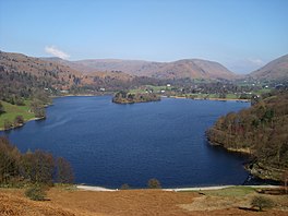
342:
301:
297:
293:
185:
535:
481:
630:
625:
416:
605:
600:
516:
211:
113:
20:
730:
362:
285:
135:
695:
615:
610:
510:
346:
312:
192:
37:
650:
620:
369:
316:
675:
670:
645:
595:
506:
320:
168:
155:
665:
660:
655:
373:
308:
289:
186:
139:
117:
200:
480:. Nottingham: English Place-Name Society. pp. lx, 423 p.136.
552:
326:
The waters of the lake are leased by the
Lowther Estate to the
311:
of 208 ft (62 m). The lake is both fed and drained by the
465:(4th ed.). Oxford: Clarendon Press. pp. l, 546.
580:
Lakes and principal tarns in the
English Lake District
463:
The concise Oxford dictionary of
English place-names
269:
265:
257:
249:
241:
233:
225:
221:
210:
198:
184:
145:
131:
30:
304:, which is immediately to the north of the lake.
417:"Grasmere Island is given to the National Trust"
146:
747:National Trust properties in the Lake District
122:Show map of the former South Lakeland district
564:
8:
333:The lake contains a single island, known as
284:is one of the smaller lakes of the English
571:
557:
549:
393:
391:
389:
27:
478:A dictionary of Lake District place-names
44:across the lake towards Grasmere village
385:
7:
711:
296:, famously associated with the poet
42:View from Loughrigg Terrace, looking
438:Hannah Furness (22 February 2017).
14:
319:, beyond which it continues into
710:
701:
700:
689:
509:
99:
98:
91:
63:
62:
55:
36:
256:
248:
240:
232:
224:
19:For the New Zealand lake, see
1:
532:An Atlas of the English Lakes
130:
82:Show map of the Lake District
530:Parker, John Wilson (2004).
372:up to around AD 1100; ON is
292:. It gives its name to the
78:Lake District National Park
763:
737:Lakes of the Lake District
18:
684:
586:
397:Parker, 2004, pages 34-36
49:
35:
16:Lake in Cumbria, England
742:South Lakeland District
461:Ekwall, Eilert (1960).
419:. BBC. 23 February 2017
476:Whaley, Diana (2006).
169:54.448834°N 3.020897°W
406:Parker, 2004, page 90
641:Haweswater Reservoir
500:Whaley, 2006, p.411,
174:54.448834; -3.020897
294:village of Grasmere
288:, in the county of
165: /
591:Bassenthwaite Lake
534:. Cicerone Press.
343:Hardwicke Rawnsley
302:Dorothy Wordsworth
298:William Wordsworth
724:
723:
442:. Daily Telegraph
279:
278:
258:Surface elevation
245:0.24mi² (0.62km²)
754:
714:
713:
704:
703:
696:Lakes portal
694:
693:
692:
573:
566:
559:
550:
545:
519:
514:
513:
501:
498:
492:
491:
473:
467:
466:
458:
452:
451:
449:
447:
435:
429:
428:
426:
424:
413:
407:
404:
398:
395:
202:
201:Primary outflows
188:
180:
179:
177:
176:
175:
170:
166:
163:
162:
161:
158:
148:
123:
102:
101:
95:
83:
76:Location in the
66:
65:
59:
40:
28:
762:
761:
757:
756:
755:
753:
752:
751:
727:
726:
725:
720:
690:
688:
680:
631:Esthwaite Water
626:Ennerdale Water
582:
577:
542:
529:
526:
515:
508:
505:
504:
499:
495:
488:
475:
474:
470:
460:
459:
455:
445:
443:
437:
436:
432:
422:
420:
415:
414:
410:
405:
401:
396:
387:
382:
359:
335:Grasmere Island
300:and his sister
214: countries
187:Primary inflows
173:
171:
167:
164:
159:
156:
154:
152:
151:
127:
126:
125:
124:
121:
120:
110:
109:
108:
107:
103:
86:
85:
84:
81:
80:
74:
73:
72:
71:
67:
45:
43:
24:
17:
12:
11:
5:
760:
758:
750:
749:
744:
739:
729:
728:
722:
721:
719:
718:
708:
698:
685:
682:
681:
679:
678:
673:
668:
663:
658:
653:
648:
643:
638:
633:
628:
623:
618:
613:
608:
606:Crummock Water
603:
601:Coniston Water
598:
593:
587:
584:
583:
578:
576:
575:
568:
561:
553:
547:
546:
540:
525:
522:
521:
520:
517:Cumbria portal
503:
502:
493:
486:
468:
453:
430:
408:
399:
384:
383:
381:
378:
358:
355:
328:National Trust
277:
276:
273:
267:
266:
263:
262:
259:
255:
254:
251:
247:
246:
243:
239:
238:
235:
231:
230:
229:1680yd (1540m)
227:
223:
222:
219:
218:
215:
208:
207:
204:
196:
195:
190:
182:
181:
149:
143:
142:
133:
129:
128:
114:South Lakeland
111:
105:
104:
97:
96:
90:
89:
88:
87:
75:
69:
68:
61:
60:
54:
53:
52:
51:
50:
47:
46:
41:
33:
32:
21:Lake Grassmere
15:
13:
10:
9:
6:
4:
3:
2:
759:
748:
745:
743:
740:
738:
735:
734:
732:
717:
709:
707:
699:
697:
687:
686:
683:
677:
674:
672:
669:
667:
664:
662:
659:
657:
654:
652:
649:
647:
644:
642:
639:
637:
634:
632:
629:
627:
624:
622:
619:
617:
614:
612:
611:Derwent Water
609:
607:
604:
602:
599:
597:
594:
592:
589:
588:
585:
581:
574:
569:
567:
562:
560:
555:
554:
551:
543:
541:1-85284-355-1
537:
533:
528:
527:
523:
518:
512:
507:
497:
494:
489:
483:
479:
472:
469:
464:
457:
454:
441:
434:
431:
418:
412:
409:
403:
400:
394:
392:
390:
386:
379:
377:
375:
371:
366:
364:
363:Eilert Ekwall
356:
354:
352:
351:Robert Hunter
348:
344:
340:
336:
331:
329:
324:
322:
318:
314:
310:
305:
303:
299:
295:
291:
287:
286:Lake District
283:
274:
272:
268:
264:
260:
252:
244:
236:
228:
220:
216:
213:
209:
205:
203:
197:
194:
191:
189:
183:
178:
150:
144:
141:
137:
136:Lake District
134:
119:
115:
94:
79:
58:
48:
39:
34:
29:
26:
22:
635:
616:Devoke Water
531:
524:Bibliography
496:
477:
471:
462:
456:
444:. Retrieved
433:
421:. Retrieved
411:
402:
367:
360:
347:Octavia Hill
338:
334:
332:
325:
313:River Rothay
306:
281:
280:
261:208 ft (62m)
242:Surface area
237:700yd (640m)
206:River Rothay
193:River Rothay
112:Location in
25:
651:Rydal Water
621:Elter Water
446:25 February
423:25 February
370:Old English
317:Rydal Water
226:Max. length
172: /
147:Coordinates
731:Categories
676:Windermere
671:Wast Water
646:Loweswater
596:Buttermere
487:0904889726
380:References
339:The Island
337:or simply
321:Windermere
253:70ft (21m)
250:Max. depth
234:Max. width
157:54°26′56″N
666:Ullswater
661:Thirlmere
656:Tarn Hows
374:Old Norse
357:Etymology
309:sea level
160:3°01′15″W
706:Category
636:Grasmere
282:Grasmere
132:Location
106:Grasmere
70:Grasmere
31:Grasmere
716:Commons
368:(OE is
290:Cumbria
271:Islands
217:England
140:Cumbria
118:Cumbria
538:
484:
212:Basin
536:ISBN
482:ISBN
448:2017
425:2017
349:and
376:.)
733::
388:^
353:.
323:.
138:,
116:,
572:e
565:t
558:v
544:.
490:.
450:.
427:.
275:1
23:.
Text is available under the Creative Commons Attribution-ShareAlike License. Additional terms may apply.