529:. From 1940 to 1991, the islands decreased in size by 5%. Some of the largest islands include Cowpens Island and Shooting Island, both of which are adjacent to Ocean City. Shooting Island, part of Cape May Wetlands Wildlife Management Area, has been eroding since at least 1930. In 2018, Act Engineers Inc. began a $ 2.75 million project to install 1,450 ft (440 m) of concrete blocks, which would provide shelter for oysters and restore the island's marshes. In the middle of the bay are the Rainbow Islands, which total 250 acres (100 ha) in area, but which are submerged during high tide.
65:
37:
440:
486:, which in the western portion of the bay is part of Lester G. McNamara Wildlife Management Area. The bay is also bounded by sandy beaches and settlements. Water depth in the bay range from less than 3.3 ft (1 m) to greater than 33 ft (10 m) in the main water channel, which extends from the Great Egg Harbor Inlet to the mouth of the Tuckahoe and Great Egg Harbor rivers.
72:
459:. The bay is part of New Jersey's backbarrier lagoon system. The bay exists as a drowned, or submerged, river valley. The waterway covers an area of 8.5 sq mi (22 km), measuring 5.0 mi (8 km) along the coast, and extending 2.8 mi (4.5 km) inland. The tidal range varies from a 5.0 ft (1.52 m)
403:
to Ocean City via Somers Point. The railroad's bridge across the Great Egg Harbor Bay burned in 1946, and was not rebuilt; the line was abandoned in 1948. In 1914, the Ocean City
Automobile Bridge Company financed the construction of a toll bridge linking Somers Point and Ocean City. In 1921, the
565:, and other turtle species, occupy the coastal waters of New Jersey, including in the bay. Dozens of bird species use the water and adjacent marsh lands as breeding grounds. Cowpens Island, located within the bay, is a bird sanctuary and a heron
489:
The channels in the bay carry sand and shell debris to the Great Egg Harbor Inlet. At the inlet, the shifting currents produce a hazardous waterway to boats, due to changes in the channel related to shoaling. To improve navigation and
683:
281:, which translates to Egg Harbor in English. The bay has a total area of 8.5 sq mi (22 km). Its depth ranges from shallow waters in the southern extension, called Peck Bay, to a 33 ft (10 m) deep channel.
373:
appointed John Somers to operate the ferry service across the Great Egg Harbor Bay to Cape May County. That year, Somers purchased land from Thomas Budd, naming the property
Somerset Plantation. John Somers' son, Richard, built
965:
346:. Over time, the river established its course to its present location. Currently, the Great Egg Harbor River and its 17 tributaries drain into the Great Egg Harbor Bay. The waterway enters the ocean between
382:
became established in 1750. During the 17th and 18th centuries, pirates and other boaters used Great Egg Harbor Bay as refuge. In 1880, one year after Ocean City was established as a
Christian resort, regular
992:
1219:
1182:
501:
Peck's Bay is a shallow extension of Great Egg Harbor Bay, located on the waterway's southern periphery between Ocean City and the Cape May County mainland. Peck's Bay also serves as part of the
691:
939:
1299:
1294:
378:
sometime between 1720 and 1726, which remains the oldest house still in existence in the county. The town name was changed to Somers Ferry, and then Somers
Plantation, until the name
969:
1245:
1011:
1030:
1065:
387:
service from Somers Point began. In 1897, the eastern boundaries of Peck Bay and Great Egg Harbor Bay served as the boundaries of newly established Ocean City.
404:
bridge became free when it was bought by the state of New Jersey, and was entirely replaced by the World War
Memorial Bridge in 1933. This bridge, designated
64:
1270:"NJ Route 52 (1) Causeway Between City of Somers Point, Atlantic County, and Ocean City, Cape May County Federal #BRF-0070103 Technical Environmental Study"
525:, which rise out of the bay to form a series of marshy islands. The islands are gradually eroding at a rate of 0.28 in (7 mm) per year, due to
475:. The tidal circulation of the bay is counterclockwise, fed by the deep channels. The quality of the water is good, despite nearby urban development and
1066:"Geomorphological Evolution of Estuaries: The Dynamic Basis for Morpho-Sedimentary Units in Selected Estuaries in the Northeastern United States"
914:
581:
along the Great Egg Harbor Bay, supporting the shipbuilding industry. Shellfish harvesting is allowed from
November 1 to April 30.
495:
46:
1126:
NJ Route 52 (1) Causeway
Between City of Somers Point, Atlantic County, and Ocean City, Cape May County Draft Environmental Impact Statement
505:, connecting the Great Egg Harbor Bay with Crook Horn Creek. This waterway is along the west side of Ocean City, which reaches the ocean at
116:
431:
opened in 1973. The 1955 bridge was replaced in 2016, and the northbound bridge was subsequently refurbished, with completion in 2019.
561:
and oysters. There are 32 species of fish in the bay, including six species that use the bay as spawning grounds. The endangered
1166:
872:
799:
213:
1131:(Report). United States Department of Transportation. August 2000. III-62, III-77, III-89, III-116, III-118, III-130, IV-II, I-13
643:
396:
642:
Joseph Dowhan; Thomas
Halavik; Andrew Milliken; Andrew MacLachlan; Marcianna Caplis; Kelly Lima; Andrew Zimba (November 1997).
456:
815:
646:. Significant Habitats and Habitat Complexes of the New York Bight Watershed. U.S. Fish and Wildlife Service. Archived from
420:
315:. In the eastern periphery, the bay measures 5.0 mi (8 km) along the coast, bordered by Ocean City on the east.
1289:
1088:
412:
370:
343:
266:
262:
98:
94:
423:
via the Great Egg Harbor Bay. This bridge was closed in 2004 due to damage, and was demolished in 2016. In 1955, the
452:
238:
234:
416:
400:
498:
has periodically dredged sand from a location 5,000 ft (1,500 m) offshore the Great Egg Harbor Inlet.
610:
588:
The barrier islands to the north and south – Ocean City and
Longport – are heavily developed, with
379:
230:
1125:
760:
303:
that covered much of southern Cape May County. Over time, the waterway shifted its course, emptying into the
424:
42:
463:
to a 2.3 ft (0.7 m) neap tide. Coastal storms can cause extreme tidal variations. The bay has a
888:
562:
362:
347:
335:
308:
285:
274:
226:
151:
502:
1204:
451:
of the Great Egg Harbor Bay, the Great Egg Harbor River joins the Middle and
Tuckahoe Rivers between
428:
351:
312:
242:
993:"Parkway to replace southbound Great Egg Harbor bridge; demolition pushed for Beesleys Point Bridge"
36:
1269:
582:
405:
50:
847:
411:
In 1928, a bridge in northern Ocean City opened, crossing Great Egg Harbor Inlet to marshlands in
735:
589:
468:
537:
The waterway and its channels carrying silt produce a soft bottom, creating a good habitat for
1162:
1154:
1080:
868:
862:
795:
491:
476:
789:
448:
841:
526:
375:
331:
304:
170:
163:
647:
365:
discovered the bay, surrounded by plentiful birds laying eggs. May named the waterway
1283:
819:
542:
506:
327:
296:
330:
period, melting glaciers formed rivers that carried sediment to the coast of the
1183:"New Jersey Shore Protection, Great Egg Harbor and Peck Beach, (Ocean City), NJ"
846:. Trenton, New Jersey: MacCrellish and Quigley, Current Printers. 1897. p.
439:
361:, who fished, clammed, and bathed in the summer months. In 1614, Dutch explorer
339:
324:
300:
293:
17:
1220:"How to ease island flooding? Some Jersey shore towns are using bayside islets"
1207:(Report). New Jersey Department of Environmental Protection. 1972. p. 126.
843:
Acts of the One Hundred and Twenty-first Legislature of the State of New Jersey
1159:
Atlantic Boating Almanacs: Sandy Hook, NJ To St. Johns River, Fl & Bermuda
553:, and worms. In shallow waters where sunlight can reach the bottom, algae and
472:
270:
102:
1084:
131:
118:
558:
546:
538:
509:, and also continues as the Intercoastal southward through Cape May County.
384:
289:
713:
569:. The region is one of the top 20 migratory bird locations in the country.
616:(Report). New Jersey Department of Environmental Protection. pp. 7–8.
578:
554:
464:
1031:"Get ready for two more years of traffic headaches at the Jersey shore"
566:
522:
668:
550:
479:. Stormwater drains in nearby Ocean City feed directly into the bay.
358:
277:'s description of the plentiful birds laying eggs, naming the waters
738:. New Jersey Department of Environmental Protection. January 3, 2018
443:
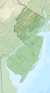
Map of Great Egg Harbor Bay, surrounding waterways, and nearby towns
427:
was built, and a parallel bridge carrying northbound traffic of the
518:
483:
438:
158:
1161:. Atlantic Boating Almanac. Vol. 3. pp. 161, 174–175.
460:
894:(Report). United States National Park Service. February 7, 1997
258:
482:
Adjacent to the bay is 18,932 acres (7,662 ha) of salty
1246:"Ocean City proposes $ 3.2 million plan to rebuild wetlands"
915:"Route 52 Causeway ready for the season in Ocean City, N.J."
415:. Also in 1928, the Ocean City Automobile Club financed the
408:, was itself replaced by a wider and taller bridge in 2012.
1272:. United States Department of Transportation. August 2000.
684:"History of the Ten Villages of Upper Township: Marmora"
585:
operations are popular along the bay in the summertime.
889:
National Register of Historic Places; Registration Form
940:"Closed bridge ties Beesleys Point to the quiet life"
1012:"Parkway traffic eases over Great Egg Harbor bridge"
861:George Woodman Hilton; John Fitzgerald Due (1960).
222:
212:
208:
200:
192:
184:
180:
169:
157:
147:
108:
89:
29:
541:that covers a 706 acres (286 ha) area. Other
369:, translated to Egg Harbor. In 1693, the court of
966:"Blast demolishes last of Beesleys Point Bridge"
299:period, the Great Egg Harbor River existed as a
109:
1148:
1146:
1300:Bodies of water of Cape May County, New Jersey
1295:Bodies of water of Atlantic County, New Jersey
577:By the 18th century, Somers Point had several
1205:Studies of The Great Egg Harbor River and Bay
557:grow. The bay serves as breeding grounds for
399:railroad line began operations, running from
8:
794:. Arcadia Publishing. pp. 11, 46, 153.
791:Ocean City: America's Greatest Family Resort
273:coast. The name derives from Dutch explorer
71:
864:The Electric Interurban Railways in America
342:at that time, covering much of what is now
41:Great Egg Harbor Bay facing west, with the
867:. Stanford University Press. p. 307.
26:
1059:
1057:
1055:
1053:
1051:
783:
781:
779:
777:
775:
773:
761:"Guide to Historic Tour of Somers Point"
671:. National Park Service. March 22, 2016.
357:The first people in the region were the
1264:
1262:
1185:. United States Army Corps of Engineers
1029:Jacqueline L. Urgo (January 15, 2017).
669:"Starting as a trickle near Berlin, NJ"
601:
545:in the bay include mussels, barnacles,
53:, and the Rainbow Islands in background
1120:
1118:
1116:
1114:
1112:
1110:
1108:
682:Robert F. Holden (February 27, 2017).
307:at the Great Egg Harbor Inlet between
1064:Norbert P. Psuty; Tanya M. Silveira.
755:
753:
644:"Great Egg Harbor Estuary Complex #3"
637:
635:
633:
631:
629:
627:
625:
623:
496:United States Army Corps of Engineers
7:
964:Columb Higgins (November 18, 2016).
1244:Michelle Brunetti (July 25, 2018).
913:Jacqueline L. Urgo (May 17, 2012).
716:. Government of Egg Harbor Township
611:Geology of Cape May County in Brief
1218:Avalon Zoppo (December 31, 2018).
1010:John DeRosier (October 18, 2016).
818:. VisitNJShore.com. Archived from
766:. Somers Point Historical Society.
419:, which connected Somers Point to
47:Beesley's Point Generating Station
25:
938:Lee Procida (December 19, 2012).
736:"New Jersey State Historic Sites"
592:modifying the natural coastline.
517:Sediment from the rivers produce
991:Michael Miller (March 2, 2011).
714:"History of Egg Harbor Township"
397:Atlantic City and Shore Railroad
204:8.5 sq mi (22 km)
70:
63:
35:
354:at the Great Egg Harbor Inlet.
292:empty into the bay. During the
218:Cowpens Island, Rainbow Islands
199:
191:
183:
1:
88:
816:"History of Ocean City, NJ"
421:Beesley's Point, New Jersey
1316:
1224:The Press of Atlantic City
1153:Peter L. Griffes (2004).
1035:The Philadelphia Inquirer
918:The Philadelphia Inquirer
196:2.8 mi (4.5 km)
58:
34:
1155:"Intracoastal Waterway"
1073:Marine Fisheries Review
609:Carol S. Lucey (1976).
467:between 17 and 32 ppt (
425:Great Egg Harbor Bridge
188:5.0 mi (8 km)
43:Great Egg Harbor Bridge
1016:Press of Atlantic City
997:Press of Atlantic City
944:Press of Atlantic City
563:Leatherback sea turtle
444:
417:Beesley's Point Bridge
363:Cornelius Jacobsen May
336:Great Egg Harbor River
286:Great Egg Harbor River
275:Cornelius Jacobsen May
152:Great Egg Harbor River
503:Intracoastal Waterway
442:
132:39.30417°N 74.64972°W
788:Fred Miller (2003).
429:Garden State Parkway
251:Great Egg Harbor Bay
78:Great Egg Harbor Bay
30:Great Egg Harbor Bay
494:in Ocean City, the
457:Egg Harbor Township
406:New Jersey Route 52
269:along the southern
137:39.30417; -74.64972
128: /
51:New Jersey Route 52
1290:Bays of New Jersey
469:parts per thousand
445:
694:on March 31, 2018
527:rising sea levels
492:replenish beaches
471:), classified as
267:Cape May counties
248:
247:
159:Ocean/sea sources
16:(Redirected from
1307:
1274:
1273:
1266:
1257:
1256:
1254:
1252:
1241:
1235:
1234:
1232:
1230:
1215:
1209:
1208:
1201:
1195:
1194:
1192:
1190:
1179:
1173:
1172:
1150:
1141:
1140:
1138:
1136:
1130:
1122:
1103:
1102:
1100:
1099:
1093:
1087:. Archived from
1070:
1061:
1046:
1045:
1043:
1041:
1026:
1020:
1019:
1007:
1001:
1000:
988:
982:
981:
979:
977:
972:on March 2, 2018
968:. Archived from
961:
955:
954:
952:
950:
935:
929:
928:
926:
924:
910:
904:
903:
901:
899:
893:
885:
879:
878:
858:
852:
851:
838:
832:
831:
829:
827:
822:on March 2, 2018
812:
806:
805:
785:
768:
767:
765:
757:
748:
747:
745:
743:
732:
726:
725:
723:
721:
710:
704:
703:
701:
699:
690:. Archived from
688:Shore News Today
679:
673:
672:
665:
659:
658:
656:
655:
639:
618:
617:
615:
606:
477:dissolved oxygen
334:. The formative
288:and its 17
255:Great Egg Harbor
160:
143:
142:
140:
139:
138:
133:
129:
126:
125:
124:
121:
111:
74:
73:
67:
39:
27:
21:
18:Great Egg Harbor
1315:
1314:
1310:
1309:
1308:
1306:
1305:
1304:
1280:
1279:
1278:
1277:
1268:
1267:
1260:
1250:
1248:
1243:
1242:
1238:
1228:
1226:
1217:
1216:
1212:
1203:
1202:
1198:
1188:
1186:
1181:
1180:
1176:
1169:
1152:
1151:
1144:
1134:
1132:
1128:
1124:
1123:
1106:
1097:
1095:
1091:
1068:
1063:
1062:
1049:
1039:
1037:
1028:
1027:
1023:
1009:
1008:
1004:
990:
989:
985:
975:
973:
963:
962:
958:
948:
946:
937:
936:
932:
922:
920:
912:
911:
907:
897:
895:
891:
887:
886:
882:
875:
860:
859:
855:
840:
839:
835:
825:
823:
814:
813:
809:
802:
787:
786:
771:
763:
759:
758:
751:
741:
739:
734:
733:
729:
719:
717:
712:
711:
707:
697:
695:
681:
680:
676:
667:
666:
662:
653:
651:
641:
640:
621:
613:
608:
607:
603:
598:
575:
535:
515:
437:
413:Atlantic County
393:
371:Cape May County
344:Cape May County
321:
173: countries
136:
134:
130:
127:
122:
119:
117:
115:
114:
85:
84:
83:
82:
81:
80:
79:
75:
54:
23:
22:
15:
12:
11:
5:
1313:
1311:
1303:
1302:
1297:
1292:
1282:
1281:
1276:
1275:
1258:
1236:
1210:
1196:
1174:
1167:
1142:
1104:
1047:
1021:
1002:
983:
956:
930:
905:
880:
873:
853:
833:
807:
800:
769:
749:
727:
705:
674:
660:
619:
600:
599:
597:
594:
574:
571:
534:
531:
514:
511:
453:Upper Township
436:
433:
392:
389:
376:Somers Mansion
332:Atlantic Ocean
320:
317:
305:Atlantic Ocean
246:
245:
239:Seaview Harbor
235:Upper Township
224:
220:
219:
216:
210:
209:
206:
205:
202:
198:
197:
194:
190:
189:
186:
182:
181:
178:
177:
174:
167:
166:
164:Atlantic Ocean
161:
155:
154:
149:
145:
144:
112:
106:
105:
91:
87:
86:
77:
76:
69:
68:
62:
61:
60:
59:
56:
55:
40:
32:
31:
24:
14:
13:
10:
9:
6:
4:
3:
2:
1312:
1301:
1298:
1296:
1293:
1291:
1288:
1287:
1285:
1271:
1265:
1263:
1259:
1247:
1240:
1237:
1225:
1221:
1214:
1211:
1206:
1200:
1197:
1184:
1178:
1175:
1170:
1168:9781577855033
1164:
1160:
1156:
1149:
1147:
1143:
1127:
1121:
1119:
1117:
1115:
1113:
1111:
1109:
1105:
1094:on 2018-03-02
1090:
1086:
1082:
1078:
1074:
1067:
1060:
1058:
1056:
1054:
1052:
1048:
1036:
1032:
1025:
1022:
1017:
1013:
1006:
1003:
998:
994:
987:
984:
971:
967:
960:
957:
945:
941:
934:
931:
919:
916:
909:
906:
890:
884:
881:
876:
874:9780804740142
870:
866:
865:
857:
854:
849:
845:
844:
837:
834:
821:
817:
811:
808:
803:
801:0-7385-2447-6
797:
793:
792:
784:
782:
780:
778:
776:
774:
770:
762:
756:
754:
750:
737:
731:
728:
715:
709:
706:
693:
689:
685:
678:
675:
670:
664:
661:
650:on 2018-07-02
649:
645:
638:
636:
634:
632:
630:
628:
626:
624:
620:
612:
605:
602:
595:
593:
591:
586:
584:
580:
572:
570:
568:
564:
560:
556:
552:
548:
544:
543:invertebrates
540:
532:
530:
528:
524:
520:
512:
510:
508:
504:
499:
497:
493:
487:
485:
480:
478:
474:
470:
466:
462:
458:
454:
450:
441:
434:
432:
430:
426:
422:
418:
414:
409:
407:
402:
401:Atlantic City
398:
395:In 1907, the
390:
388:
386:
381:
377:
372:
368:
364:
360:
355:
353:
349:
345:
341:
338:existed as a
337:
333:
329:
326:
318:
316:
314:
310:
306:
302:
298:
295:
291:
287:
282:
280:
276:
272:
268:
264:
260:
256:
252:
244:
240:
236:
232:
228:
225:
221:
217:
215:
211:
207:
203:
195:
187:
179:
176:United States
175:
172:
168:
165:
162:
156:
153:
150:
148:River sources
146:
141:
113:
107:
104:
100:
96:
92:
66:
57:
52:
48:
44:
38:
33:
28:
19:
1249:. Retrieved
1239:
1227:. Retrieved
1223:
1213:
1199:
1189:December 22,
1187:. Retrieved
1177:
1158:
1133:. Retrieved
1096:. Retrieved
1089:the original
1079:(3): 38–39.
1076:
1072:
1038:. Retrieved
1034:
1024:
1015:
1005:
996:
986:
974:. Retrieved
970:the original
959:
947:. Retrieved
943:
933:
921:. Retrieved
917:
908:
896:. Retrieved
883:
863:
856:
842:
836:
824:. Retrieved
820:the original
810:
790:
740:. Retrieved
730:
718:. Retrieved
708:
696:. Retrieved
692:the original
687:
677:
663:
652:. Retrieved
648:the original
604:
587:
576:
536:
516:
507:Corson Inlet
500:
488:
481:
446:
410:
394:
380:Somers Point
366:
356:
328:interglacial
322:
297:interglacial
283:
278:
254:
250:
249:
231:Somers Point
201:Surface area
93:Counties of
461:spring tide
367:Eyren Haven
359:Leni-Lenape
325:Sangamonian
323:During the
294:Sangamonian
290:tributaries
279:Eyren Haven
223:Settlements
185:Max. length
135: /
110:Coordinates
1284:Categories
1098:2018-03-01
654:2018-03-01
596:References
559:hard clams
555:seagrasses
473:polyhaline
348:Ocean City
309:Ocean City
271:New Jersey
227:Ocean City
193:Max. width
123:74°38′59″W
120:39°18′15″N
103:New Jersey
1085:0090-1830
720:April 14,
590:bulkheads
579:shipyards
547:amphipods
539:shellfish
533:Ecosystem
391:Crossings
385:steamboat
1135:March 2,
1040:March 1,
976:March 1,
949:March 1,
923:March 1,
898:March 1,
826:March 1,
742:March 1,
698:March 1,
573:Industry
523:mudflats
465:salinity
435:Features
352:Longport
313:Longport
263:Atlantic
261:between
243:Longport
99:Cape May
95:Atlantic
90:Location
1251:July 1,
1229:July 1,
583:Jet ski
567:rookery
513:Islands
484:marshes
447:At the
319:History
257:) is a
214:Islands
1165:
1083:
871:
798:
551:mysids
519:shoals
1129:(PDF)
1092:(PDF)
1069:(PDF)
892:(PDF)
764:(PDF)
614:(PDF)
340:delta
301:delta
171:Basin
1253:2019
1231:2019
1191:2017
1163:ISBN
1137:2018
1081:ISSN
1042:2018
978:2018
951:2018
925:2018
900:2018
869:ISBN
828:2018
796:ISBN
744:2018
722:2018
700:2018
521:and
455:and
449:head
350:and
311:and
284:The
265:and
253:(or
97:and
848:107
259:bay
101:in
1286::
1261:^
1222:.
1157:.
1145:^
1107:^
1077:71
1075:.
1071:.
1050:^
1033:.
1014:.
995:.
942:.
772:^
752:^
686:.
622:^
549:,
241:,
237:,
233:,
229:,
49:,
45:,
1255:.
1233:.
1193:.
1171:.
1139:.
1101:.
1044:.
1018:.
999:.
980:.
953:.
927:.
902:.
877:.
850:.
830:.
804:.
746:.
724:.
702:.
657:.
20:)
Text is available under the Creative Commons Attribution-ShareAlike License. Additional terms may apply.