17:
111:
83:
102:
layers indicate periodic avalanches from the shallower waters. Portions of the same limestone avalanches that came to rest further up the coastal slopes are featured at Cow Head. There, the individual rocks in the limestone
260:
59:. The boundary is a section 60m thick composed of layers of shale and limestone with overturned beds dipping 60-70 degrees to the South East. It is marked by the first appearance of
137:
265:
36:
56:
280:
275:
221:
55:
In 2000, the cliffs at Green Point were approved as the Global
Stratotype Section and Point for the base of the Ordovician system by the
194:
173:
Cooper, R. A., Nowlan, G. S., and
Williams, S. H. (2001). Global Stratotype Section and Point for Base of the Ordovician System.
270:
35:. It is the home to a small summer fishing community and a drive-in campground. In 2000, Green Point was designated the
61:
132:
75:
28:
104:
32:
94:
represent a 30 million year record of deep-ocean sediments laid in a base-of-slope environment in the
159:
190:
16:
189:
Burzynski, M. (1999). Gros Morne
National Park. St. John's, NL: Breakwater Books. p.44
254:
95:
158:
Gros Morne
National Park: Visitor information (2007) Retrieved August 18, 2008 from
208:
178:
70:
44:
236:
223:
213:
99:
110:
82:
66:
40:
91:
109:
81:
160:
http://www.pc.gc.ca/pn-np/nl/grosmorne/visit/visit4_e.asp#04
27:
is located 12 km north of the town of Rocky
Harbour in
209:
Overview of Global
Boundary Stratotype Sections and Points
138:
List of Global
Boundary Stratotype Sections and Points
261:Paleozoic paleontological sites of North America
123:There are 31 drive-in campsites at Green Point.
69:fossil, 4.8m below the earliest known planktic
39:(GSSP) representing the division between the
8:
179:http://www.stratigraphy.org/Tremadocian.pdf
57:International Union of Geological Sciences
177:, 24(1). Retrieved August 18, 2008, from
15:
148:
266:Landforms of Newfoundland and Labrador
169:
167:
154:
152:
7:
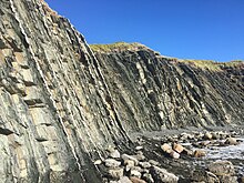
86:Cliffs layers viewed from the side.
37:Global Stratotype Section and Point
214:Gros Morne National Park of Canada
14:
281:Ordovician paleontological sites
276:Cambrian paleontological sites
1:
297:
76:Rhabdinopora praeparabola
62:Iapetognathus fluctivagus
133:Gros Morne National Park
29:Gros Morne National Park
31:, on the west coast of
20:Green Point at low tide
271:Paleontology in Canada
115:
87:
21:
237:49.68222°N 57.95528°W
114:Exposed cliff layers.
113:
85:
19:
242:49.68222; -57.95528
233: /
116:
88:
22:
107:are much larger.
288:
248:
247:
245:
244:
243:
238:
234:
231:
230:
229:
226:
197:
187:
181:
171:
162:
156:
296:
295:
291:
290:
289:
287:
286:
285:
251:
250:
241:
239:
235:
232:
227:
224:
222:
220:
219:
205:
200:
188:
184:
172:
165:
157:
150:
146:
129:
121:
53:
12:
11:
5:
294:
292:
284:
283:
278:
273:
268:
263:
253:
252:
217:
216:
211:
204:
203:External links
201:
199:
198:
182:
163:
147:
145:
142:
141:
140:
135:
128:
125:
120:
117:
52:
49:
13:
10:
9:
6:
4:
3:
2:
293:
282:
279:
277:
274:
272:
269:
267:
264:
262:
259:
258:
256:
249:
246:
215:
212:
210:
207:
206:
202:
196:
195:1-55081-135-5
192:
186:
183:
180:
176:
170:
168:
164:
161:
155:
153:
149:
143:
139:
136:
134:
131:
130:
126:
124:
118:
112:
108:
106:
101:
97:
96:Iapetus Ocean
93:
84:
80:
78:
77:
72:
68:
64:
63:
58:
50:
48:
46:
42:
38:
34:
30:
26:
18:
218:
185:
174:
122:
105:conglomerate
89:
74:
60:
54:
33:Newfoundland
24:
23:
240: /
25:Green Point
255:Categories
228:57°57′19″W
225:49°40′56″N
144:References
119:Campground
71:graptolite
45:Ordovician
100:limestone
47:systems.
175:Episodes
127:See also
73:fossil,
67:conodont
43:and the
41:Cambrian
51:Geology
193:
98:. The
92:shales
191:ISBN
90:The
65:, a
257::
166:^
151:^
79:.
Text is available under the Creative Commons Attribution-ShareAlike License. Additional terms may apply.