68:
80:
984:
53:
325:
193:
690:
In the township the population was spread out, with 24.6% under the age of 18, 9.3% from 18 to 24, 27.7% from 25 to 44, 24.5% from 45 to 64, and 13.9% who were 65 years of age or older. The median age was 37 years. For every 100 females there were 91.6 males. For every 100 females age 18 and over,
686:
living together, 13.6% had a female householder with no husband present, and 28.0% were non-families. 24.5% of all households were made up of individuals, and 11.3% had someone living alone who was 65 years of age or older. The average household size was 2.51 and the average family size was 2.96.
650:
of 2000, there were 3,904 people, 1,549 households, and 1,115 families residing in the township. The population density was 108.7 inhabitants per square mile (42.0/km). There were 1,697 housing units at an average density of 47.3 per square mile (18.3/km). The racial makeup of the township was
67:
346:
1610:
694:
The median income for a household in the township was $ 27,790, and the median income for a family was $ 31,902. Males had a median income of $ 30,156 versus $ 17,449 for females. The
922:
460:
passes to the east of
Claysburg along the side of Dunning Mountain, with access from Exit 15 near the southern edge of the township. Other communities in the township include
1111:
19:
434:
418:
1659:
1081:
1076:
1061:
438:
1649:
1131:
422:
79:
1654:
1101:
1086:
426:
406:
402:
1514:
1126:
1121:
1116:
1096:
410:
1564:
1284:
1106:
1066:
795:
915:
262:
1389:
1254:
500:
496:
1209:
1154:
1554:
1524:
1324:
1449:
1384:
1404:
908:
1664:
1374:
372:
1369:
1304:
719:
225:
112:
1469:
749:
449:
52:
900:
656:
350:
1239:
660:
308:
1494:
1364:
1274:
1184:
1071:
1027:
430:
414:
1587:
1179:
1169:
1012:
954:
871:
668:
484:
335:
799:
1544:
1534:
1509:
1359:
1309:
1234:
1229:
1224:
1043:
1007:
932:
832:
297:
117:
354:
339:
1559:
1394:
1339:
1264:
1259:
1199:
1189:
1174:
1164:
1017:
612:
597:
582:
567:
552:
537:
473:
1489:
1444:
1439:
1429:
1299:
1289:
1279:
1219:
1204:
1149:
1032:
796:"Geographic Identifiers: 2010 Demographic Profile Data (G001): Greenfield township, Blair County, Pennsylvania"
469:
250:
90:
682:
There were 1,549 households, out of which 32.7% had children under the age of 18 living with them, 52.9% were
1484:
1464:
1459:
1434:
1409:
1329:
1319:
1314:
1194:
1159:
1141:
1053:
445:
293:
43:
1529:
1424:
1419:
1399:
1349:
1294:
1269:
1249:
1002:
994:
672:
1504:
1334:
1244:
973:
461:
1594:
1539:
1519:
1414:
1038:
676:
477:
235:
1499:
1479:
1474:
1454:
1379:
1354:
1344:
1022:
965:
698:
for the township was $ 14,168. About 14.1% of families and 16.6% of the population were below the
664:
652:
465:
1549:
1214:
845:
769:
695:
401:
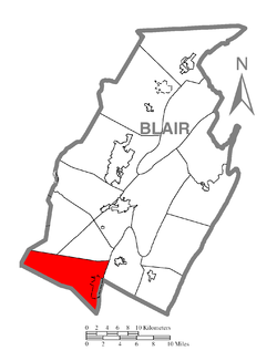
Greenfield
Township is located in the southwestern corner of Blair County. It is bordered by
781:
1643:
457:
453:
255:
57:
699:
301:
105:
820:
947:
487:, the township has a total area of 36.3 square miles (93.9 km), all land.
324:
305:
499:
is located in the western portion of the township, and three small parcels of
448:
is the primary settlement in
Greenfield Township, occupying the valley of the
100:
1625:
1612:
216:
702:, including 20.6% of those under age 18 and 17.0% of those age 65 or over.
1578:‡This populated place also has portions in an adjacent county or counties
683:
276:
647:
895:
242:
221:
72:
Map of Blair County, Pennsylvania highlighting
Greenfield Township
904:
318:
982:
867:
798:. U.S. Census Bureau, American Factfinder. Archived from
437:
touching
Greenfield Township at its southwest corner and
18:
503:
are located in the southwestern corner of the township.
743:
741:
739:
737:
1573:
1140:
1052:
993:
964:
271:
261:
249:
232:
215:
207:
199:
186:
181:
173:
165:
157:
152:
144:
139:
131:
123:
111:
99:
89:
30:
20:Greenfield Township, Pennsylvania (disambiguation)
821:https://viewer.nationalmap.gov/advanced-viewer/
311:. The population was 3,785 at the 2020 census.
916:
8:
750:"City and Town Population Totals: 2020-2022"
353:. Unsourced material may be challenged and
923:
909:
901:
823:The National Map, retrieved 3 October 2018
679:of any race were 0.36% of the population.
510:
27:
373:Learn how and when to remove this message
1660:Townships in Blair County, Pennsylvania
833:Pennsylvania State Game Lands Number 26
711:
497:Pennsylvania State Game Lands Number 26
456:near the eastern edge of the township.
270:
260:
248:
214:
180:
151:
138:
122:
88:
64:
49:
25:Township in Pennsylvania, United States
777:
767:
530:
231:
206:
198:
185:
172:
169:36.25 sq mi (93.89 km)
164:
161:36.25 sq mi (93.89 km)
156:
143:
130:
110:
98:
76:
7:
1650:Populated places established in 1770
896:Greenfield Township official website
671:, and 0.61% from two or more races.
351:adding citations to reliable sources
1655:1770 establishments in Pennsylvania
304:, United States. It is part of the
177:0.00 sq mi (0.00 km)
931:Municipalities and communities of
846:"Census of Population and Housing"
520:
417:is to the south, and specifically
14:
84:Map of Blair County, Pennsylvania
444:The unincorporated community of
323:
192:
191:
78:
66:
51:
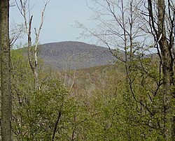
60:, Blair County's highest point
1:
1515:Spring Drive Mobile Home Park
722:. United States Census Bureau
392:Local telephone exchange: 239
309:Metropolitan Statistical Area
441:sharing the western border.
211:111.81/sq mi (43.17/km)
872:United States Census Bureau
720:"2016 U.S. Gazetteer Files"
485:United States Census Bureau
200: • Estimate
1681:
934:Blair County, Pennsylvania
835:, retrieved 3 October 2018
17:
1665:Townships in Pennsylvania
1583:
980:
945:
639:
626:
611:
596:
581:
566:
551:
536:
529:
524:
519:
516:
77:
65:
50:
41:
1325:Homewood at Martinsburg
691:there were 89.9 males.
987:
1626:40.24889°N 78.44972°W
986:
868:"U.S. Census website"
640:U.S. Decennial Census
512:Historical population
433:is to the west, with
279:.greenfieldtownshippa
234: • Summer (
1596:United States portal
1375:Martinsburg Junction
501:Game Lands Number 41
409:to the north and by
347:improve this section
208: • Density
148:Board of Supervisors
32:Greenfield Township,
1631:40.24889; -78.44972
1622: /
1589:Pennsylvania portal
802:on 12 February 2020
748:Bureau, US Census.
513:
435:Summerhill Township
419:Bloomfield Township
315:General information
290:Greenfield Township
988:
780:has generic name (
756:. US Census Bureau
511:
429:to the southwest.
425:to the south, and
421:to the southeast,
413:to the northeast.
187: • Total
174: • Water
158: • Total
1605:
1604:
1470:Robeson Extension
696:per capita income
644:
643:
495:A portion of the
483:According to the
450:Frankstown Branch
383:
382:
375:
287:
286:
166: • Land
145: • Type
1672:
1637:
1636:
1634:
1633:
1632:
1627:
1623:
1620:
1619:
1618:
1615:
1597:
1590:
985:
957:
950:
940:
935:
925:
918:
911:
902:
883:
882:
880:
878:
864:
858:
857:
855:
853:
842:
836:
830:
824:
818:
812:
811:
809:
807:
792:
786:
785:
779:
775:
773:
765:
763:
761:
745:
732:
731:
729:
727:
716:
657:African American
532:
527:
522:
514:
439:Portage Township
407:Freedom Township
403:Juniata Township
378:
371:
367:
364:
358:
327:
319:
283:
280:
278:
239:
195:
194:
82:
70:
55:
28:
1680:
1679:
1675:
1674:
1673:
1671:
1670:
1669:
1640:
1639:
1630:
1628:
1624:
1621:
1616:
1613:
1611:
1609:
1608:
1606:
1601:
1595:
1588:
1579:
1569:
1240:East Sharpsburg
1136:
1048:
989:
983:
978:
960:
955:
948:
941:
938:
933:
929:
892:
887:
886:
876:
874:
866:
865:
861:
851:
849:
844:
843:
839:
831:
827:
819:
815:
805:
803:
794:
793:
789:
776:
766:
759:
757:
747:
746:
735:
725:
723:
718:
717:
713:
708:
684:married couples
661:Native American
525:
509:
493:
423:Kimmel Township
411:Taylor Township
399:
386:ZIP code: 16625
379:
368:
362:
359:
344:
328:
317:
275:
233:
85:
73:
61:
46:
37:
35:
33:
26:
23:
12:
11:
5:
1678:
1676:
1668:
1667:
1662:
1657:
1652:
1642:
1641:
1603:
1602:
1600:
1599:
1592:
1584:
1581:
1580:
1577:
1575:
1571:
1570:
1568:
1567:
1565:Yellow Springs
1562:
1557:
1552:
1547:
1542:
1537:
1532:
1527:
1522:
1517:
1512:
1507:
1502:
1497:
1495:Sickles Corner
1492:
1487:
1482:
1477:
1472:
1467:
1462:
1457:
1452:
1447:
1442:
1437:
1432:
1427:
1422:
1417:
1412:
1407:
1402:
1397:
1392:
1387:
1382:
1377:
1372:
1367:
1365:Linds Crossing
1362:
1357:
1352:
1347:
1342:
1337:
1332:
1327:
1322:
1317:
1312:
1307:
1302:
1297:
1292:
1287:
1285:Fredericksburg
1282:
1277:
1275:Franklin Forge
1272:
1267:
1262:
1257:
1252:
1247:
1242:
1237:
1232:
1227:
1222:
1217:
1212:
1207:
1202:
1197:
1192:
1187:
1185:Charlottsville
1182:
1177:
1172:
1167:
1162:
1157:
1152:
1146:
1144:
1138:
1137:
1135:
1134:
1129:
1124:
1119:
1114:
1112:North Woodbury
1109:
1104:
1099:
1094:
1089:
1084:
1079:
1074:
1069:
1064:
1058:
1056:
1050:
1049:
1047:
1046:
1041:
1036:
1030:
1028:Roaring Spring
1025:
1020:
1015:
1010:
1005:
999:
997:
991:
990:
981:
979:
977:
976:
970:
968:
962:
961:
946:
943:
942:
930:
928:
927:
920:
913:
905:
899:
898:
891:
890:External links
888:
885:
884:
859:
837:
825:
813:
787:
733:
710:
709:
707:
704:
642:
641:
637:
636:
633:
631:
628:
624:
623:
620:
618:
615:
609:
608:
605:
603:
600:
594:
593:
590:
588:
585:
579:
578:
575:
573:
570:
564:
563:
560:
558:
555:
549:
548:
545:
543:
540:
534:
533:
528:
523:
518:
508:
505:
492:
489:
431:Cambria County
427:Pavia Township
415:Bedford County
398:
395:
394:
393:
390:
389:Area code: 814
387:
381:
380:
331:
329:
322:
316:
313:
285:
284:
273:
269:
268:
265:
259:
258:
253:
247:
246:
240:
230:
229:
219:
213:
212:
209:
205:
204:
201:
197:
196:
188:
184:
183:
179:
178:
175:
171:
170:
167:
163:
162:
159:
155:
154:
150:
149:
146:
142:
141:
137:
136:
133:
129:
128:
125:
121:
120:
115:
109:
108:
103:
97:
96:
93:
87:
86:
83:
75:
74:
71:
63:
62:
56:
48:
47:
42:
39:
38:
31:
24:
13:
10:
9:
6:
4:
3:
2:
1677:
1666:
1663:
1661:
1658:
1656:
1653:
1651:
1648:
1647:
1645:
1638:
1635:
1598:
1593:
1591:
1586:
1585:
1582:
1576:
1572:
1566:
1563:
1561:
1558:
1556:
1553:
1551:
1548:
1546:
1543:
1541:
1538:
1536:
1533:
1531:
1528:
1526:
1523:
1521:
1518:
1516:
1513:
1511:
1508:
1506:
1503:
1501:
1498:
1496:
1493:
1491:
1488:
1486:
1483:
1481:
1478:
1476:
1473:
1471:
1468:
1466:
1463:
1461:
1458:
1456:
1453:
1451:
1448:
1446:
1443:
1441:
1438:
1436:
1433:
1431:
1428:
1426:
1423:
1421:
1418:
1416:
1413:
1411:
1408:
1406:
1403:
1401:
1398:
1396:
1393:
1391:
1388:
1386:
1383:
1381:
1378:
1376:
1373:
1371:
1368:
1366:
1363:
1361:
1358:
1356:
1353:
1351:
1348:
1346:
1343:
1341:
1338:
1336:
1333:
1331:
1328:
1326:
1323:
1321:
1318:
1316:
1313:
1311:
1308:
1306:
1303:
1301:
1298:
1296:
1293:
1291:
1288:
1286:
1283:
1281:
1278:
1276:
1273:
1271:
1268:
1266:
1263:
1261:
1258:
1256:
1253:
1251:
1248:
1246:
1243:
1241:
1238:
1236:
1233:
1231:
1228:
1226:
1223:
1221:
1218:
1216:
1213:
1211:
1208:
1206:
1203:
1201:
1198:
1196:
1193:
1191:
1188:
1186:
1183:
1181:
1180:Carson Valley
1178:
1176:
1173:
1171:
1170:Canan Station
1168:
1166:
1163:
1161:
1158:
1156:
1153:
1151:
1148:
1147:
1145:
1143:
1139:
1133:
1130:
1128:
1125:
1123:
1120:
1118:
1115:
1113:
1110:
1108:
1105:
1103:
1100:
1098:
1095:
1093:
1090:
1088:
1085:
1083:
1080:
1078:
1075:
1073:
1070:
1068:
1065:
1063:
1060:
1059:
1057:
1055:
1051:
1045:
1042:
1040:
1037:
1034:
1031:
1029:
1026:
1024:
1021:
1019:
1016:
1014:
1013:Hollidaysburg
1011:
1009:
1006:
1004:
1001:
1000:
998:
996:
992:
975:
972:
971:
969:
967:
963:
959:
958:
956:Hollidaysburg
951:
944:
939:United States
936:
926:
921:
919:
914:
912:
907:
906:
903:
897:
894:
893:
889:
873:
869:
863:
860:
847:
841:
838:
834:
829:
826:
822:
817:
814:
801:
797:
791:
788:
783:
771:
755:
751:
744:
742:
740:
738:
734:
721:
715:
712:
705:
703:
701:
697:
692:
688:
685:
680:
678:
674:
670:
667:, 0.18% from
666:
662:
658:
654:
649:
638:
634:
632:
629:
625:
621:
619:
616:
614:
610:
606:
604:
601:
599:
595:
591:
589:
586:
584:
580:
576:
574:
571:
569:
565:
561:
559:
556:
554:
550:
546:
544:
541:
539:
535:
515:
506:
504:
502:
498:
490:
488:
486:
481:
479:
475:
471:
467:
463:
459:
458:Interstate 99
455:
454:Juniata River
451:
447:
442:
440:
436:
432:
428:
424:
420:
416:
412:
408:
404:
396:
391:
388:
385:
384:
377:
374:
366:
356:
352:
348:
342:
341:
337:
332:This section
330:
326:
321:
320:
314:
312:
310:
307:
303:
299:
295:
291:
282:
274:
266:
264:
257:
254:
252:
244:
241:
237:
227:
226:Eastern (EST)
223:
220:
218:
210:
202:
189:
176:
168:
160:
147:
134:
126:
119:
116:
114:
107:
104:
102:
95:United States
94:
92:
81:
69:
59:
58:Schaefer Head
54:
45:
40:
34:Blair County,
29:
21:
16:
1607:
1545:Tyrone Forge
1535:Sylvan Hills
1510:Smith Corner
1360:Leamersville
1310:Grazierville
1235:East Freedom
1230:East Altoona
1225:Dumb Hundred
1091:
1044:Williamsburg
1008:Duncansville
953:
875:. Retrieved
862:
850:. Retrieved
848:. Census.gov
840:
828:
816:
804:. Retrieved
800:the original
790:
778:|last1=
758:. Retrieved
753:
724:. Retrieved
714:
700:poverty line
693:
689:
681:
645:
507:Demographics
494:
482:
443:
400:
369:
360:
345:Please help
333:
302:Pennsylvania
298:Blair County
289:
288:
267:42-013-31000
132:Incorporated
106:Pennsylvania
36:Pennsylvania
15:
1629: /
1560:Wopsononock
1395:Moores Mill
1390:Millerstown
1340:Juniata Gap
1265:Fort Fetter
1260:Foot of Ten
1255:Fisherville
1200:Cotton Town
1190:Clappertown
1175:Canoe Creek
1165:Brooks Mill
1018:Martinsburg
949:County seat
669:other races
627:2022 (est.)
474:Cotton Town
306:Altoona, PA
1644:Categories
1617:78°26′59″W
1614:40°14′56″N
1490:Shellytown
1445:Puzzletown
1440:Point View
1430:Penn Farms
1300:Geeseytown
1290:Friesville
1280:Frankstown
1220:Curryville
1210:Cross Keys
1205:Cove Forge
1155:Beavertown
1150:Bald Eagle
1092:Greenfield
1082:Frankstown
1033:Tunnelhill
877:31 January
754:Census.gov
706:References
646:As of the
491:Recreation
470:Friesville
363:March 2018
182:Population
140:Government
1574:Footnotes
1555:Vicksburg
1525:St. Clair
1485:Shelltown
1465:Reservoir
1460:Reightown
1435:Pinecroft
1410:Northwood
1330:Ironville
1320:Henrietta
1315:Greenwood
1195:Claysburg
1160:Blue Knob
1077:Catharine
1062:Allegheny
1054:Townships
726:13 August
446:Claysburg
397:Geography
334:does not
263:FIPS code
251:Area code
217:Time zone
1530:Sunbrook
1450:Red Hill
1425:Oreminea
1420:Ore Hill
1400:Nealmont
1385:Mill Run
1350:Lakemont
1295:Ganister
1270:Fostoria
1250:Eldorado
1132:Woodbury
1003:Bellwood
995:Boroughs
806:11 March
770:cite web
673:Hispanic
663:, 0.03%
659:, 0.08%
655:, 0.15%
294:township
44:Township
1505:Ski Gap
1405:Newburg
1335:Jugtown
1245:Elberta
1102:Juniata
1087:Freedom
974:Altoona
760:5 March
651:98.95%
462:Ski Gap
452:of the
355:removed
340:sources
272:Website
124:Settled
91:Country
1540:Tipton
1520:Sproul
1415:Olivia
1127:Tyrone
1122:Taylor
1117:Snyder
1097:Huston
1039:Tyrone
852:4 June
677:Latino
648:census
517:Census
478:Sproul
476:, and
190:3,785
113:County
1500:Skelp
1480:Royer
1475:Roots
1455:Reese
1380:McKee
1355:Larke
1345:Klahr
1107:Logan
1072:Blair
1067:Antis
1023:Newry
665:Asian
653:White
635:−1.8%
630:3,715
622:−9.3%
617:3,785
602:4,173
587:3,904
572:3,802
557:3,758
542:3,543
466:Klahr
292:is a
245:(EDT)
243:UTC-4
222:UTC-5
203:3,715
118:Blair
101:State
1550:Vail
1370:Loop
1305:Gray
1215:Culp
1142:CDPs
966:City
879:2008
854:2016
808:2014
782:help
762:2024
728:2017
613:2020
607:6.9%
598:2010
592:2.7%
583:2000
577:1.2%
568:1990
562:6.1%
553:1980
538:1970
526:Note
521:Pop.
405:and
338:any
336:cite
281:.gov
153:Area
135:1846
127:1770
675:or
349:by
296:in
277:www
256:814
236:DST
1646::
952::
937:,
870:.
774::
772:}}
768:{{
752:.
736:^
531:%±
480:.
472:,
468:,
464:,
300:,
1035:‡
924:e
917:t
910:v
881:.
856:.
810:.
784:)
764:.
730:.
547:—
376:)
370:(
365:)
361:(
357:.
343:.
238:)
228:)
224:(
22:.
Text is available under the Creative Commons Attribution-ShareAlike License. Additional terms may apply.