24:
257:
242:
252:
193:
61:
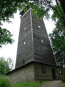
Observation Tower which was erected in 1934 and burned down after a lightning strike in 1953. The new structure was built 43 years later, in 1996.
102:
237:
232:
178:
127:
58:
247:
65:
49:. Its height is 29 meters and it has one viewing platform. Foot tower altitude is 631 meters above sea level.
17:
143:
174:
123:
98:
34:
69:
42:
38:
226:
72:, the now defunct Šumperk District and telephone operators who use the tower as a
73:
46:
208:
195:
170:
22:
23:
120:
Průvodce po nejkrásnějších místech Čech, Moravy a
Slezska
57:
The current observation tower replaced the original
258:20th-century architecture in the Czech Republic
64:Investors were the municipalities of Šumperk,
8:
97:(3., opr. vyd. ed.). Praha: Dokořán.
243:Observation towers in the Czech Republic
85:
253:1934 establishments in Czechoslovakia
122:(1. vyd. ed.). Olomouc: Rubico.
7:
45:, about 3 kilometres northwest from
173:: Nakladatelství 555. p. 131.
14:
167:Rozhledny Čech, Moravy a Slezska
1:
274:
37:on the top of Háj hill in
15:
209:49.9705528°N 16.9338472°E
146:(in Czech). ejeseniky.com
144:"Rozhledna Háj - Šumperk"
93:Miškovský, Pavel (2008).
238:Towers completed in 1996
233:Towers completed in 1934
118:Knápek, Zdeněk (2002).
214:49.9705528; 16.9338472
27:
26:
16:For other uses, see
205: /
165:Nouza, Jan (1999).
28:
104:978-80-7363-189-5
35:observation tower
265:
248:Šumperk District
220:
219:
217:
216:
215:
210:
206:
203:
202:
201:
198:
185:
184:
162:
156:
155:
153:
151:
140:
134:
133:
115:
109:
108:
90:
70:Ruda nad Moravou
273:
272:
268:
267:
266:
264:
263:
262:
223:
222:
213:
211:
207:
204:
199:
196:
194:
192:
191:
189:
188:
181:
164:
163:
159:
149:
147:
142:
141:
137:
130:
117:
116:
112:
105:
92:
91:
87:
82:
55:
21:
12:
11:
5:
271:
269:
261:
260:
255:
250:
245:
240:
235:
225:
224:
187:
186:
179:
157:
135:
128:
110:
103:
95:Naše rozhledny
84:
83:
81:
78:
54:
51:
43:Czech Republic
39:Olomouc Region
13:
10:
9:
6:
4:
3:
2:
270:
259:
256:
254:
251:
249:
246:
244:
241:
239:
236:
234:
231:
230:
228:
221:
218:
197:49°58′13.99″N
182:
180:80-902590-4-9
176:
172:
168:
161:
158:
145:
139:
136:
131:
125:
121:
114:
111:
106:
100:
96:
89:
86:
79:
77:
75:
71:
67:
62:
60:
52:
50:
48:
44:
40:
36:
32:
25:
19:
200:16°56′1.85″E
190:
169:(in Czech).
166:
160:
148:. Retrieved
138:
119:
113:
94:
88:
63:
56:
30:
29:
212: /
74:transmitter
227:Categories
129:8085839601
80:References
59:Štefánik's
171:Liberec
150:9 March
53:History
47:Šumperk
41:of the
177:
126:
101:
66:Bludov
33:is an
175:ISBN
152:2013
124:ISBN
99:ISBN
31:Háj
18:Háj
229::
76:.
68:,
183:.
154:.
132:.
107:.
20:.
Text is available under the Creative Commons Attribution-ShareAlike License. Additional terms may apply.