852:
211:
864:
151:
888:
198:
1091:
876:
176:
963:
571:) with large seasonal temperature differences, with warm to hot (and often humid) summers and cold (sometimes severely cold) winters. Precipitation is significant throughout the year, but is heaviest from August to October. The average annual temperature in Hachirōgata is 11.1 °C. The average annual rainfall is 1612 mm with September as the wettest month. The temperatures are highest on average in August, at around 24.8 °C, and lowest in January, at around -1.0 °C.
166:
1137:
455:
953:
926:
22:
761:
1039:
218:
813:. The village of Omogata was established in 1889 with the establishment of the modern municipalities system, the town of Hitoichi in 1925. The two merged in 1956 to form the town of Hachirōgata. Efforts to merge the town with neighboring Gojōme and Ikawa failed to pass a referendum in 2005.
851:
863:
210:
502:
of 330 persons per km. The total area is 17.00 square kilometres (6.56 sq mi). It is the smallest municipality in Akita
Prefecture in terms of surface area.
150:
242:
911:
Hachirōgata has one public elementary schools and one public middle schools operated by the town government. The town does not have a high school.
1090:
39:
887:
875:
1330:
86:
197:
1354:
58:
838:
175:
105:
579:
Per
Japanese census data, the population of Hachirōgata peaked at around the year 1950 and has been in steady decline since then.
565:
65:
1080:
43:
1349:
1136:
72:
1043:
165:
1246:
1058:
830:
315:
54:
518:
which lies in the west of the town. Lake Hachirōgata was the second largest lake in Japan until it was drained in a
929:
1234:
1108:
561:
1302:
286:
274:
833:
contributes one member to the Akita
Prefectural Assembly. In terms of national politics, the town is part of
1290:
32:
1273:
1222:
966:
939:
522:
project from 1957 to 1977.The town is about 30 kilometers north of the prefectural capital at Akita City.
79:
1278:
1118:
298:
773:
1073:
378:
1012:
454:
834:
810:
499:
310:
1251:
1239:
1094:
956:
534:
519:
511:
487:
442:
303:
291:
1307:
1156:
1312:
1266:
933:
549:
1191:
1176:
1066:
515:
483:
141:
1343:
1317:
1295:
1227:
1206:
1196:
1171:
1161:
1151:
978:
842:
822:
806:
794:
544:
1023:
1261:
1126:
1103:
829:
town council of 12 members. Hachirōgata, together with the other municipalities of
539:
1201:
769:
798:
21:
1283:
1181:
826:
802:
495:
257:
244:
1166:
925:
369:
903:
The economy of Hachirōgata is based on agriculture and commercial fishing.
1038:
1186:
998:
1050:
407:
687:
600:
768:
Graphs are unavailable due to technical issues. There is more info on
432:
374:
491:
453:
397:
Jidaidō 80, Hachirōgata-machi, Minamiakita-gun, Akita-ken 018-1692
279:
1062:
754:
15:
510:
Hachirōgata is located in the coastal flatlands northeastern
494:. As of 1 February 2023, the town had an estimated
682:
595:
793:
The area of present-day Hachirōgata was part of ancient
825:
form of government with a directly elected mayor and a
1215:
1144:
1117:
438:
428:
401:
393:
385:
368:
360:
352:
347:
339:
334:
326:
321:
309:
297:
285:
273:
123:
46:. Unsourced material may be challenged and removed.
869:A sunset view of Hachirōgata, from Mikurabana Park
857:Panoramic view of Hachirōgata and Ōgata, from Oga
155:Panorama view of Hachirōgata, from Tennō Sky Tower
473:
467:
129:
1074:
8:
582:
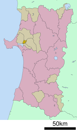
190:Location of Hachirōgata in Akita Prefecture
1081:
1067:
1059:
581:
120:
106:Learn how and when to remove this message
991:
847:
423:
400:
384:
367:
346:
333:
320:
272:
237:
203:
187:
159:
147:
437:
427:
392:
359:
351:
338:
325:
308:
296:
284:
194:
7:
999:Hachirōgata Town official statistics
981:, Japanese national badminton player
343:17.00 km (6.56 sq mi)
44:adding citations to reliable sources
1331:List of mergers in Akita Prefecture
330:Kiku Hatayama (from September 2008)
217:
514:, bordered by the remnant of Lake
498:of 5603 in 2465 households, and a
14:
1024:Hachirōgata population statistics
1135:
1089:
1037:
961:
951:
924:
886:
874:
862:
850:
759:
216:
209:
196:
174:
164:
149:
20:
31:needs additional citations for
1:
881:Hitoichi Bon dancing festival
566:Köppen climate classification
474:
1371:
930:East Japan Railway Company
586:
526:Neighboring municipalities
1355:Towns in Akita Prefecture
1328:
1133:
1101:
752:
613:—
562:Humid continental climate
468:
448:
424:
419:
415:
238:
204:
195:
188:
160:
148:
139:
130:
1013:Hachirōgata climate data
893:Tanbo art in Hachirogata
127:
364:330/km (850/sq mi)
459:
258:39.94944°N 140.07333°E
1046:at Wikimedia Commons
967:National Route 7
583:Historical population
458:Hachirōgata Town Hall
457:
118:Town in Tōhoku, Japan
1247:Minamiakita District
831:Minamiakita District
361: • Density
55:"Hachirōgata, Akita"
40:improve this article
797:, dominated by the
584:
379:Japan Standard Time
263:39.94944; 140.07333
254: /
1350:Hachirōgata, Akita
1235:Kitaakita District
1044:Hachirogata, Akita
835:Akita 2nd district
821:Hachirōgata has a
811:Tokugawa shogunate
560:Hachirōgata has a
500:population density
460:
353: • Total
340: • Total
327: • Mayor
1337:
1336:
1303:Yamamoto District
1112:
1042:Media related to
786:
785:
781:
780:
748:
747:
672:
671:
530:Akita Prefecture
475:Hachirōgata-machi
452:
451:
386:Phone number
116:
115:
108:
90:
1362:
1291:Senboku District
1139:
1106:
1095:Akita Prefecture
1093:
1083:
1076:
1069:
1060:
1055:
1051:Official Website
1041:
1026:
1021:
1015:
1010:
1004:
1003:
996:
965:
964:
957:Akita Expressway
955:
954:
928:
890:
878:
866:
854:
763:
762:
755:
689:
684:
676:
675:
602:
597:
589:
588:
585:
520:land reclamation
512:Akita Prefecture
481:
480:
477:
471:
470:
443:Japanese Zelkova
411:
410:
408:Official website
269:
268:
266:
265:
264:
259:
255:
252:
251:
250:
247:
220:
219:
213:
200:
178:
168:
153:
134:
133:
132:
121:
111:
104:
100:
97:
91:
89:
48:
24:
16:
1370:
1369:
1365:
1364:
1363:
1361:
1360:
1359:
1340:
1339:
1338:
1333:
1324:
1274:Ogachi District
1223:Kazuno District
1211:
1140:
1131:
1113:
1097:
1087:
1053:
1035:
1030:
1029:
1022:
1018:
1011:
1007:
1001:
997:
993:
988:
975:
973:Notable peoples
962:
952:
948:
922:
917:
909:
901:
894:
891:
882:
879:
870:
867:
858:
855:
819:
791:
782:
777:
764:
760:
577:
558:
528:
508:
478:
465:
406:
405:
262:
260:
256:
253:
248:
245:
243:
241:
240:
234:
233:
232:
231:
228:
227:
226:
225:
221:
191:
184:
183:
182:
181:
172:
171:
156:
144:
135:
128:
126:
119:
112:
101:
95:
92:
49:
47:
37:
25:
12:
11:
5:
1368:
1366:
1358:
1357:
1352:
1342:
1341:
1335:
1334:
1329:
1326:
1325:
1323:
1322:
1321:
1320:
1315:
1310:
1300:
1299:
1298:
1288:
1287:
1286:
1281:
1271:
1270:
1269:
1264:
1259:
1254:
1244:
1243:
1242:
1232:
1231:
1230:
1219:
1217:
1213:
1212:
1210:
1209:
1204:
1199:
1194:
1189:
1184:
1179:
1174:
1169:
1164:
1159:
1154:
1148:
1146:
1142:
1141:
1134:
1132:
1130:
1129:
1123:
1121:
1115:
1114:
1102:
1099:
1098:
1088:
1086:
1085:
1078:
1071:
1063:
1057:
1056:
1034:
1033:External links
1031:
1028:
1027:
1016:
1005:
990:
989:
987:
984:
983:
982:
974:
971:
970:
969:
959:
947:
944:
943:
942:
921:
918:
916:
915:Transportation
913:
908:
905:
900:
897:
896:
895:
892:
885:
883:
880:
873:
871:
868:
861:
859:
856:
849:
818:
815:
790:
787:
784:
783:
779:
778:
767:
765:
758:
753:
750:
749:
746:
745:
742:
739:
735:
734:
731:
728:
724:
723:
720:
717:
713:
712:
709:
706:
702:
701:
698:
695:
691:
690:
685:
680:
673:
670:
669:
666:
663:
659:
658:
655:
652:
648:
647:
644:
641:
637:
636:
633:
630:
626:
625:
622:
619:
615:
614:
611:
608:
604:
603:
598:
593:
576:
573:
557:
554:
553:
552:
547:
542:
537:
527:
524:
507:
504:
450:
449:
446:
445:
440:
436:
435:
430:
426:
425:
422:
421:
417:
416:
413:
412:
403:
399:
398:
395:
391:
390:
387:
383:
382:
372:
366:
365:
362:
358:
357:
354:
350:
349:
345:
344:
341:
337:
336:
332:
331:
328:
324:
323:
319:
318:
313:
307:
306:
301:
295:
294:
289:
283:
282:
277:
271:
270:
236:
235:
229:
223:
222:
215:
214:
208:
207:
206:
205:
202:
201:
193:
192:
189:
186:
185:
179:
173:
169:
163:
162:
161:
158:
157:
154:
146:
145:
140:
137:
136:
124:
117:
114:
113:
28:
26:
19:
13:
10:
9:
6:
4:
3:
2:
1367:
1356:
1353:
1351:
1348:
1347:
1345:
1332:
1327:
1319:
1316:
1314:
1311:
1309:
1306:
1305:
1304:
1301:
1297:
1294:
1293:
1292:
1289:
1285:
1282:
1280:
1279:Higashinaruse
1277:
1276:
1275:
1272:
1268:
1265:
1263:
1260:
1258:
1255:
1253:
1250:
1249:
1248:
1245:
1241:
1238:
1237:
1236:
1233:
1229:
1226:
1225:
1224:
1221:
1220:
1218:
1214:
1208:
1205:
1203:
1200:
1198:
1195:
1193:
1190:
1188:
1185:
1183:
1180:
1178:
1175:
1173:
1170:
1168:
1165:
1163:
1160:
1158:
1155:
1153:
1150:
1149:
1147:
1143:
1138:
1128:
1125:
1124:
1122:
1120:
1116:
1110:
1105:
1100:
1096:
1092:
1084:
1079:
1077:
1072:
1070:
1065:
1064:
1061:
1054:(in Japanese)
1052:
1049:
1048:
1047:
1045:
1040:
1032:
1025:
1020:
1017:
1014:
1009:
1006:
1002:(in Japanese)
1000:
995:
992:
985:
980:
979:Chiharu Shida
977:
976:
972:
968:
960:
958:
950:
949:
945:
941:
938:
937:
936:
935:
931:
927:
919:
914:
912:
906:
904:
898:
889:
884:
877:
872:
865:
860:
853:
848:
846:
844:
843:Diet of Japan
840:
836:
832:
828:
824:
823:mayor-council
816:
814:
812:
808:
807:Kubota Domain
804:
800:
796:
795:Dewa Province
788:
775:
774:MediaWiki.org
771:
766:
757:
756:
751:
743:
740:
737:
736:
732:
729:
726:
725:
721:
718:
715:
714:
710:
707:
704:
703:
699:
696:
693:
692:
686:
681:
678:
677:
674:
667:
664:
661:
660:
656:
653:
650:
649:
645:
642:
639:
638:
634:
631:
628:
627:
623:
620:
617:
616:
612:
609:
606:
605:
599:
594:
591:
590:
587:
580:
574:
572:
570:
567:
563:
555:
551:
548:
546:
543:
541:
538:
536:
533:
532:
531:
525:
523:
521:
517:
513:
505:
503:
501:
497:
493:
489:
485:
476:
464:
456:
447:
444:
441:
434:
431:
418:
414:
409:
404:
396:
388:
380:
376:
373:
371:
363:
355:
342:
329:
317:
314:
312:
305:
302:
300:
293:
290:
288:
281:
278:
276:
267:
239:Coordinates:
212:
199:
177:
167:
152:
143:
138:
122:
110:
107:
99:
88:
85:
81:
78:
74:
71:
67:
64:
60:
57: –
56:
52:
51:Find sources:
45:
41:
35:
34:
29:This article
27:
23:
18:
17:
1256:
1036:
1019:
1008:
994:
934:Ōu Main Line
923:
910:
902:
820:
805:, who ruled
792:
578:
575:Demographics
568:
559:
529:
509:
462:
461:
389:018-875-5800
102:
96:October 2022
93:
83:
76:
69:
62:
50:
38:Please help
33:verification
30:
1257:Hachirōgata
940:Hachirōgata
839:lower house
801:during the
799:Satake clan
770:Phabricator
516:Hachirōgata
486:located in
463:Hachirōgata
316:Minamiakita
261: /
224:Hachirōgata
125:Hachirōgata
1344:Categories
986:References
827:unicameral
817:Government
809:under the
803:Edo period
496:population
348:Population
322:Government
299:Prefecture
249:140°4′24″E
246:39°56′58″N
66:newspapers
1240:Kamikoani
1216:Districts
1202:Yurihonjō
1167:Kitaakita
1119:Core city
907:Education
506:Geography
370:Time zone
1308:Fujisato
1157:Katagami
311:District
1192:Semboku
1177:Noshiro
1109:capital
946:Highway
920:Railway
899:Economy
841:of the
837:of the
789:History
772:and on
688:±% p.a.
601:±% p.a.
556:Climate
420:Symbols
402:Website
394:Address
275:Country
80:scholar
1318:Mitane
1296:Misato
1252:Gojōme
1228:Kosaka
1207:Yuzawa
1197:Yokote
1172:Nikaho
1162:Kazuno
1152:Daisen
1145:Cities
744:−1.70%
733:−1.28%
722:−0.79%
711:−0.09%
700:+0.06%
668:−0.22%
657:−0.45%
646:+2.01%
635:+0.88%
624:+1.20%
545:Mitane
535:Gojōme
433:Azalea
429:Flower
292:Tōhoku
287:Region
230:
82:
75:
68:
61:
53:
1313:Happō
1267:Ōgata
1262:Ikawa
1187:Ōdate
1127:Akita
1104:Akita
741:5,583
738:2020
730:6,624
727:2010
719:7,533
716:2000
708:8,153
705:1990
697:8,228
694:1980
665:8,180
662:1970
654:8,358
651:1960
643:8,743
640:1950
632:7,166
629:1940
621:6,568
618:1930
610:5,831
607:1920
550:Ōgata
540:Ikawa
492:Japan
488:Akita
482:is a
375:UTC+9
356:5,603
304:Akita
280:Japan
87:JSTOR
73:books
683:Pop.
679:Year
596:Pop.
592:Year
484:town
469:八郎潟町
439:Tree
335:Area
180:Seal
170:Flag
142:Town
131:八郎潟町
59:news
1284:Ugo
1182:Oga
569:Cfa
42:by
1346::
932:-
845:.
490:,
472:,
1111:)
1107:(
1082:e
1075:t
1068:v
776:.
564:(
479:)
466:(
381:)
377:(
109:)
103:(
98:)
94:(
84:·
77:·
70:·
63:·
36:.
Text is available under the Creative Commons Attribution-ShareAlike License. Additional terms may apply.