41:
357:
1367:
63:
694:
70:
257:
546:
402:, the Attorney General to Henry VII. He acquired the estate from Sir Roger de Hales whose daughter had married the Duke of Norfolk. In 1666, the last Hales heiress was Lady Dionysia Williamson, who left her estate to her nephew John Hoskins.
603:
737:
586:"Clavering Hundred: Hales, or Lodden-Hales Pages 16-21 An Essay Towards A Topographical History of the County of Norfolk: Volume 8. Originally published by W Miller, London, 1808"
171:
281:
730:
1408:
723:
128:
520:
269:
323:
1432:
286:
667:
1437:
826:
305:
274:
241:
207:
634:
1401:
1061:
613:
417:
411:
373:, England. It covers an area of 3.99 km (1.54 sq mi) and had a population of 479 in 192 households as of the
360:
62:
49:
388:
The manor of Hales dates back to the
Domesday book. From the 11th century to the 17th century, Hales manor was held by the
121:
1427:
781:
609:
567:
433:
40:
432:, this church probably comes closest to the original appearance of an early round-tower church. It is in care of the
374:
866:
1394:
1111:
315:
310:
1161:
221:
916:
585:
356:
1101:
20:
1176:
1171:
861:
1196:
1081:
262:
153:
1256:
1051:
976:
46:
705:
1346:
1116:
946:
421:
189:
111:
698:
1366:
1276:
1221:
876:
500:
1378:
524:
1226:
1166:
1136:
1126:
1036:
1026:
981:
966:
886:
791:
642:
246:
1301:
1271:
1106:
1091:
961:
941:
906:
846:
841:
473:
437:
197:
1151:
1131:
856:
682:
389:
1421:
1146:
1096:
1086:
1046:
991:
936:
921:
871:
796:
776:
750:
161:
1331:
1236:
1056:
986:
746:
399:
137:
715:
1316:
1246:
1211:
1156:
1066:
926:
901:
831:
811:
488:
1336:
1311:
1286:
1281:
1241:
1231:
1191:
1141:
1071:
1041:
1031:
1016:
1006:
816:
395:
338:
325:
1341:
1306:
1201:
996:
971:
896:
881:
836:
821:
806:
771:
453:
429:
231:
710:
693:
1326:
1291:
1261:
1251:
1216:
1186:
1076:
1021:
1011:
956:
801:
786:
483:
1374:
1321:
1266:
1206:
1121:
951:
931:
911:
851:
761:
478:
449:
425:
370:
213:
179:
83:
1296:
891:
766:
1181:
646:
355:
719:
706:
St
Margaret's on the European Round Tower Churches Website
1382:
523:. South Norfolk Council. 31 March 2008. Archived from
683:
http://kepn.nottingham.ac.uk/map/place/Norfolk/Hales
280:
268:
256:
240:
230:
220:
206:
188:
170:
152:
136:
120:
109:
101:
93:
33:
645:, Institute of Historic Building Conservation and
377:, which had reduced to 469 at the 2011 census.
464:The Pastures is a care home on Yarmouth Road.
1402:
731:
8:
568:"The story of Hales Hall and the Great Barn"
827:Brandon Parva, Coston, Runhall and Welborne
1409:
1395:
738:
724:
716:
668:"X2 X21 X22 Lowestoft - Beccles - Norwich"
385:The village's name means 'Nooks of land'.
30:
512:
251:
229:
205:
119:
92:
37:
279:
267:
255:
239:
219:
187:
169:
151:
108:
7:
1363:
1361:
97:3.99 km (1.54 sq mi)
1381:. You can help Knowledge (XXG) by
14:
1365:
692:
68:
61:
39:
1062:Kimberley and Carleton Forehoe
635:"Church of St Margaret, Hales"
1:
448:The X2 bus service goes from
390:De Hales, later Hales, family
69:
867:Caistor St Edmund and Bixley
782:Ashwellthorpe and Fundenhall
610:Churches Conservation Trust
434:Churches Conservation Trust
418:Church of Hales St Margaret
412:St Margaret's Church, Hales
122:OS grid reference
50:Church of Hales St Margaret
28:Human settlement in England
16:Village in Norfolk, England
1454:
1360:
521:"Hales parish information"
409:
18:
1433:Civil parishes in Norfolk
1112:Morningthorpe and Fritton
757:
296:
292:
252:
56:
38:
1162:Redenhall with Harleston
639:Heritage Gateway website
547:"Parish population 2011"
436:, and is a Grade I
1438:Norfolk geography stubs
917:Dickleburgh and Rushall
420:is one of 124 existing
116:118/km (310/sq mi)
1377:location article is a
1102:Marlingford and Colton
590:British History Online
369:is a small village in
363:
339:52.521861°N 1.509247°E
242:Postcode district
21:Hales (disambiguation)
1177:Saxlingham Nethergate
862:Burston and Shimpling
701:at Wikimedia Commons
406:Church of St Margaret
398:was built in 1478 by
359:
1197:Shelton and Hardwick
1082:Langley with Hardley
711:Photos from Geograph
641:, Heritage Gateway (
422:round-tower churches
222:Sovereign state
19:For other uses, see
1428:Villages in Norfolk
1257:Tharston and Hapton
1052:Keswick and Intwood
527:on 22 November 2008
344:52.521861; 1.509247
335: /
616:on 19 January 2011
605:St Margaret, Hales
364:
1390:
1389:
1355:
1354:
877:Carleton St Peter
697:Media related to
501:Clavering hundred
361:Hales St Margaret
354:
353:
172:Shire county
1445:
1411:
1404:
1397:
1369:
1362:
1227:Stoke Holy Cross
1167:Rockland St Mary
1137:Norton Subcourse
967:Framingham Pigot
740:
733:
726:
717:
696:
676:
675:
664:
658:
657:
656:
654:
643:English Heritage
631:
625:
624:
623:
621:
612:, archived from
600:
594:
593:
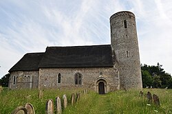
582:
576:
575:
564:
558:
557:
555:
553:
543:
537:
536:
534:
532:
517:
400:Sir James Hobart
350:
349:
347:
346:
345:
340:
336:
333:
332:
331:
328:
302:
216:
132:
131:
82:Location within
72:
71:
65:
43:
31:
1453:
1452:
1448:
1447:
1446:
1444:
1443:
1442:
1418:
1417:
1416:
1415:
1358:
1356:
1351:
962:Framingham Earl
753:
744:
690:
680:
679:
666:
665:
661:
652:
650:
633:
632:
628:
619:
617:
602:
601:
597:
584:
583:
579:
566:
565:
561:
551:
549:
545:
544:
540:
530:
528:
519:
518:
514:
509:
497:
470:
462:
452:in the west to
446:
438:listed building
414:
408:
383:
343:
341:
337:
334:
329:
326:
324:
322:
321:
320:
300:
287:East of England
212:
202:
184:
166:
148:
127:
126:
105:469 (2011)
89:
88:
87:
86:
80:
79:
78:
77:
73:
52:
29:
24:
17:
12:
11:
5:
1451:
1449:
1441:
1440:
1435:
1430:
1420:
1419:
1414:
1413:
1406:
1399:
1391:
1388:
1387:
1370:
1353:
1352:
1350:
1349:
1344:
1339:
1334:
1329:
1324:
1319:
1314:
1309:
1304:
1299:
1294:
1289:
1284:
1279:
1274:
1269:
1264:
1259:
1254:
1249:
1244:
1239:
1234:
1229:
1224:
1219:
1214:
1209:
1204:
1199:
1194:
1189:
1184:
1179:
1174:
1169:
1164:
1159:
1154:
1152:Pulham St Mary
1149:
1144:
1139:
1134:
1132:Newton Flotman
1129:
1124:
1119:
1114:
1109:
1104:
1099:
1094:
1089:
1084:
1079:
1074:
1069:
1064:
1059:
1054:
1049:
1044:
1039:
1034:
1029:
1024:
1019:
1014:
1009:
1004:
999:
994:
989:
984:
979:
974:
969:
964:
959:
954:
949:
944:
939:
934:
929:
924:
919:
914:
909:
904:
899:
894:
889:
884:
879:
874:
869:
864:
859:
857:Burgh St Peter
854:
849:
844:
839:
834:
829:
824:
819:
814:
809:
804:
799:
794:
789:
784:
779:
774:
769:
764:
758:
755:
754:
747:Civil parishes
745:
743:
742:
735:
728:
720:
714:
713:
708:
689:
688:External links
686:
678:
677:
659:
626:
595:
577:
559:
538:
511:
510:
508:
505:
504:
503:
496:
493:
492:
491:
486:
481:
476:
469:
468:Nearest places
466:
461:
458:
445:
442:
410:Main article:
407:
404:
382:
379:
352:
351:
319:
318:
313:
308:
303:
301:List of places
297:
294:
293:
290:
289:
284:
278:
277:
272:
266:
265:
260:
254:
253:
250:
249:
244:
238:
237:
234:
228:
227:
226:United Kingdom
224:
218:
217:
210:
204:
203:
201:
200:
194:
192:
186:
185:
183:
182:
176:
174:
168:
167:
165:
164:
158:
156:
150:
149:
147:
146:
142:
140:
134:
133:
124:
118:
117:
114:
107:
106:
103:
99:
98:
95:
91:
90:
81:
75:
74:
67:
66:
60:
59:
58:
57:
54:
53:
44:
36:
35:
27:
15:
13:
10:
9:
6:
4:
3:
2:
1450:
1439:
1436:
1434:
1431:
1429:
1426:
1425:
1423:
1412:
1407:
1405:
1400:
1398:
1393:
1392:
1386:
1384:
1380:
1376:
1371:
1368:
1364:
1359:
1348:
1345:
1343:
1340:
1338:
1335:
1333:
1330:
1328:
1325:
1323:
1320:
1318:
1315:
1313:
1310:
1308:
1305:
1303:
1300:
1298:
1295:
1293:
1290:
1288:
1285:
1283:
1280:
1278:
1275:
1273:
1270:
1268:
1265:
1263:
1260:
1258:
1255:
1253:
1250:
1248:
1245:
1243:
1240:
1238:
1235:
1233:
1230:
1228:
1225:
1223:
1220:
1218:
1215:
1213:
1210:
1208:
1205:
1203:
1200:
1198:
1195:
1193:
1190:
1188:
1185:
1183:
1180:
1178:
1175:
1173:
1170:
1168:
1165:
1163:
1160:
1158:
1155:
1153:
1150:
1148:
1147:Pulham Market
1145:
1143:
1140:
1138:
1135:
1133:
1130:
1128:
1125:
1123:
1120:
1118:
1115:
1113:
1110:
1108:
1105:
1103:
1100:
1098:
1097:Long Stratton
1095:
1093:
1090:
1088:
1087:Little Melton
1085:
1083:
1080:
1078:
1075:
1073:
1070:
1068:
1065:
1063:
1060:
1058:
1055:
1053:
1050:
1048:
1045:
1043:
1040:
1038:
1035:
1033:
1030:
1028:
1025:
1023:
1020:
1018:
1015:
1013:
1010:
1008:
1005:
1003:
1000:
998:
995:
993:
992:Great Moulton
990:
988:
985:
983:
980:
978:
975:
973:
970:
968:
965:
963:
960:
958:
955:
953:
950:
948:
945:
943:
940:
938:
937:East Carleton
935:
933:
930:
928:
925:
923:
920:
918:
915:
913:
910:
908:
905:
903:
900:
898:
895:
893:
890:
888:
885:
883:
880:
878:
875:
873:
872:Carleton Rode
870:
868:
865:
863:
860:
858:
855:
853:
850:
848:
845:
843:
840:
838:
835:
833:
830:
828:
825:
823:
820:
818:
815:
813:
810:
808:
805:
803:
800:
798:
797:Barnham Broom
795:
793:
790:
788:
785:
783:
780:
778:
777:Ashby St Mary
775:
773:
770:
768:
765:
763:
760:
759:
756:
752:
751:South Norfolk
748:
741:
736:
734:
729:
727:
722:
721:
718:
712:
709:
707:
704:
703:
702:
700:
695:
687:
685:
684:
673:
669:
663:
660:
648:
647:ALGAO:England
644:
640:
636:
630:
627:
615:
611:
607:
606:
599:
596:
591:
587:
581:
578:
573:
569:
563:
560:
548:
542:
539:
526:
522:
516:
513:
506:
502:
499:
498:
494:
490:
487:
485:
482:
480:
477:
475:
472:
471:
467:
465:
459:
457:
456:in the east.
455:
451:
443:
441:
439:
435:
431:
430:thatched roof
427:
423:
419:
413:
405:
403:
401:
397:
393:
391:
386:
380:
378:
376:
372:
368:
362:
358:
348:
317:
314:
312:
309:
307:
304:
299:
298:
295:
291:
288:
285:
283:
276:
273:
271:
264:
261:
259:
248:
245:
243:
235:
233:
225:
223:
215:
211:
209:
199:
196:
195:
193:
191:
181:
178:
177:
175:
173:
163:
162:South Norfolk
160:
159:
157:
155:
144:
143:
141:
139:
135:
130:
125:
123:
115:
113:
104:
100:
96:
85:
64:
55:
51:
48:
42:
32:
26:
22:
1383:expanding it
1372:
1357:
1332:Wramplingham
1237:Swainsthorpe
1057:Ketteringham
1001:
987:Great Melton
691:
681:
671:
662:
651:, retrieved
638:
629:
618:, retrieved
614:the original
604:
598:
589:
580:
571:
562:
550:. Retrieved
541:
529:. Retrieved
525:the original
515:
463:
447:
415:
394:
387:
384:
366:
365:
138:Civil parish
25:
1317:Winfarthing
1247:Tacolneston
1212:Spooner Row
1157:Raveningham
1067:Kirby Bedon
927:Ditchingham
902:Cringleford
832:Bressingham
812:Bergh Apton
672:First Group
552:7 September
489:Raveningham
428:. With its
375:2001 census
342: /
1422:Categories
1337:Wreningham
1312:Wicklewood
1287:Toft Monks
1282:Tivetshall
1242:Swardeston
1232:Surlingham
1192:Shelfanger
1142:Poringland
1072:Kirby Cane
1042:Holverston
1032:Hethersett
1017:Hellington
1007:Heckingham
977:Gillingham
817:Bracon Ash
572:Hales Hall
507:References
396:Hales Hall
327:52°31′19″N
102:Population
1347:Yelverton
1342:Wymondham
1307:Wheatacre
1202:Shotesham
1117:Mulbarton
997:Haddiscoe
972:Geldeston
947:Ellingham
897:Costessey
882:Chedgrave
837:Brockdish
822:Bramerton
807:Bedingham
772:Alpington
653:5 January
620:5 January
460:Amenities
454:Lowestoft
444:Transport
330:1°30′33″E
282:Ambulance
232:Post town
1327:Wortwell
1292:Topcroft
1277:Tibenham
1262:Thurlton
1252:Tasburgh
1222:Stockton
1217:Starston
1187:Seething
1077:Kirstead
1022:Hempnall
1012:Hedenham
957:Forncett
802:Bawburgh
787:Aslacton
495:See also
484:Thurlton
154:District
129:TM382972
1375:Norfolk
1322:Woodton
1272:Thwaite
1267:Thurton
1207:Sisland
1127:Needham
1122:Mundham
1037:Hingham
1027:Heywood
982:Gissing
952:Flordon
932:Earsham
912:Deopham
887:Claxton
852:Bunwell
792:Barford
762:Alburgh
649:), 2006
531:20 June
479:Thurton
450:Norwich
426:Norfolk
381:History
371:Norfolk
316:Norfolk
311:England
275:Norfolk
263:Norfolk
236:NORWICH
214:England
208:Country
180:Norfolk
112:Density
110:•
84:Norfolk
1302:Wacton
1297:Trowse
1172:Roydon
1107:Morley
1092:Loddon
942:Easton
907:Denton
892:Colney
847:Broome
842:Brooke
767:Aldeby
474:Loddon
258:Police
190:Region
47:Norman
1373:This
1182:Scole
1002:Hales
699:Hales
367:Hales
145:Hales
76:Hales
34:Hales
1379:stub
1047:Howe
922:Diss
655:2011
622:2011
554:2015
533:2009
416:The
270:Fire
247:NR14
198:East
94:Area
45:The
749:of
424:in
392:.
1424::
670:.
637:,
608:,
588:.
570:.
440:.
306:UK
1410:e
1403:t
1396:v
1385:.
739:e
732:t
725:v
674:.
592:.
574:.
556:.
535:.
23:.
Text is available under the Creative Commons Attribution-ShareAlike License. Additional terms may apply.