262:
involve many long cave dives – nothing of which on such a scale has ever been attempted in
Indiana. Such a connection would likely greatly expand the known lengths of both caves as there are still significant gaps of unexplored cave in between the two systems. Binkley's currently measures around 44 miles (71 km) in length – the longest known cave in Indiana and the seventh longest cave known in the United States – and its known extent is increasing due to the efforts of the ISS. Cave divers led by Dave Strickland have mapped several thousand feet of cave in Harrison Spring – all of which was at a significant depth, and entirely underwater.
49:
1146:
254:, the largest known cave in Indiana, the cavers of the Indiana Speleological Survey (ISS) have noted that according to their cave mapping data, water in the Blowing Hole section of Binkley's appears to flow under the bed of Indian Creek, near the Sinks of Indian Creek, and resurge at Harrison Spring. This is further proven by dye trace studies performed in the sinkhole plain containing Binkley's Cave.
33:
1172:
56:
261:
south of
Corydon has been observed to flow through known parts of Binkley's Cave, subterraneally under Indian Creek, exit to the surface at Harrison Spring, and flow to the Blue River. There may be a link under Indian Creek between Harrison Spring and Binkley's Cave. However the route would certainly
219:
of
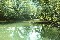
Harrison Spring is, by Indiana standards, very large. Indian Creek is a major infeeder to the Harrison Springs drainage system as the entire summer flow of Indian Creek can disappear at the Sinks of Indian Creek and re-emerge at Harrison Springs in low-flow conditions, in about one hour. Given
265:
The rise pool at
Harrison Spring measures approximately 120 feet (37 m) by 95 feet (29 m). It is within an abandoned meander loop of Blue River. Divers have measured its depth to be about 45 feet (14 m). Harrison Spring has an average discharge of 100 cubic feet per second
397:
709:
762:
461:
787:
506:
1203:
619:
303:
downstream which began operating 1807, making it one of the first in the state. The farm was known as
Harrison Valley. Harrison had planned to make it a plantation similar to
390:
235:
The other major known drainage basin is nearly entirely subsurface karst drainage and includes a known area that runs from
Harrison Spring to the north and northeast to
1208:
383:
719:
585:
266:(2.8 m/s) with a flood discharge of up to 900 cubic feet per second (25 m/s). The water from the spring overflows into an outlet that travels about
648:
612:
1164:
1078:
658:
114:
1091:
860:
772:
1126:
704:
628:
1028:
1176:
1150:
1111:
955:
822:
605:
521:
48:
1023:
406:
1121:
1116:
1086:
699:
663:
1018:
370:
232:, the Indian Creek portion of the Harrison Spring drainage basin alone drains an area of at least 200 square miles (520 km).
1101:
1096:
905:
875:
832:
802:
673:
566:
1038:
1157:
1131:
1106:
985:
345:
441:
334:
995:
807:
526:
225:
1043:
1058:
915:
880:
107:
1198:
1048:
1013:
965:
847:
653:
757:
727:
456:
421:
551:
315:
159:
895:
885:
752:
737:
691:
451:
431:
196:
86:
1068:
935:
930:
870:
855:
681:
289:
240:
1008:
980:
960:
950:
865:
732:
556:
541:
426:
292:
258:
501:
975:
970:
817:
640:
561:
536:
251:
1063:
1053:
827:
308:
277:
204:
200:
188:
100:
17:
1033:
945:
920:
890:
812:
531:
257:
Surface water that sinks into the sinkhole plain in areas near the intersection of Shiloh Road and
229:
486:
471:
1003:
925:
900:
481:
288:
The spring is privately owned. It was once part of a large 600-acre (2.4 km) farm owned by
940:
910:
792:
511:
228:, as well as Little Indian Creek (an infeeder to Big Indian) drains an area that runs east of
244:
221:
365:
837:
571:
476:
236:
375:
220:
that Big Indian Creek – upstream of the Sinks of Indian Creek – drains an area between
216:
1192:
782:
496:
777:
747:
546:
491:
446:
32:
797:
516:
742:
436:
304:
597:
129:
116:
296:
295:, from whom it gains its name. The spring produced enough water to run a
632:
410:
300:
192:
90:
64:
346:
Water
Resources If Indiana and Ohio, by Frank Leverett, 1897, Pg 483
247:
and contains an area of at least 39 square miles (100 km).
601:
379:
307:, and a shipyard. However, the outlawing of slavery by the
355:
2007 NSS Convention
Guidebook: Bassett 2007: pages 212–217
335:
Amazing Tales from
Indiana By Fred D. Cavinder, 1990, Pg 6
1077:
994:
846:
718:
690:
672:
639:
166:
157:
145:
106:
96:
82:
74:
25:
366:Harrison Spring: One of the Largest in the Midwest
215:Several dye trace studies have shown that the
613:
391:
8:
649:George Rogers Clark National Historical Park
243:, just 2–3 miles (3.2–4.8 km) south of
1204:Bodies of water of Harrison County, Indiana
620:
606:
598:
398:
384:
376:
22:
818:Rocky Hollow-Falls Canyon Nature Preserve
537:Rocky Hollow Falls Canyon Nature Preserve
738:Calvert and Porter Woods Nature Preserve
318:in 1980, but is not open to the public.
1165:Indiana Department of Natural Resources
659:Lewis and Clark National Historic Trail
327:
276:mile (1.2 km) before merging with
55:
442:Davis-Purdue Agriculture Center Forest
16:For the town in British Columbia, see
1209:National Natural Landmarks in Indiana
586:List including county and description
165:
156:
7:
1171:
73:
788:Ohio Coral Reef (Falls of the Ohio)
14:
664:Lincoln Boyhood National Memorial
1170:
1145:
1144:
522:Pioneer Mother's Memorial Forest
195:. It is located in west-central
81:
54:
47:
31:
803:Pioneer Mothers Memorial Forest
748:Donaldson Cave System and Woods
567:Wesselman Woods Nature Preserve
447:Donaldson Cave System and Woods
314:The spring was registered as a
144:
311:of 1816 made this impossible.
160:U.S. National Natural Landmark
1:
1079:State Fish and Wildlife Areas
808:Portland Arch Nature Preserve
527:Portland Arch Nature Preserve
823:Tamarack Bog Nature Preserve
763:Hanging Rock and Wabash Reef
462:Hanging Rock and Wabash Reef
654:Indiana Dunes National Park
1225:
758:Fern Cliff Nature Preserve
720:National Natural Landmarks
457:Fern Cliff Nature Preserve
407:National Natural Landmarks
15:
1140:
692:National Wildlife Refuges
580:
552:Thornhill Nature Preserve
417:
316:National Natural Landmark
178:
174:
153:
42:
30:
432:Calvert and Porter Woods
793:Pine Hills Natural Area
512:Pine Hills Natural Area
290:United States President
250:While mapping parts of
733:Cabin Creek Raised Bog
427:Cabin Creek Raised Bog
293:William Henry Harrison
259:Indiana State Road 135
753:Dunes Nature Preserve
641:National Park Service
452:Dunes Nature Preserve
191:in the U.S. state of
149:7 acres (2.8 ha)
833:Wesselman Park Woods
557:Tolliver Shallowhole
542:Shrader-Weaver Woods
309:Indiana Constitution
18:Harrison Hot Springs
986:Whitewater Memorial
813:Rise at Orangeville
532:Rise at Orangeville
130:38.2443°N 86.2251°W
126: /
1199:Springs of Indiana
1029:Jackson–Washington
828:Wesley Chapel Gulf
562:Wesley Chapel Gulf
203:and just north of
1186:
1185:
1024:Harrison–Crawford
906:McCormick's Creek
881:Falls of the Ohio
595:
594:
182:
181:
135:38.2443; -86.2251
97:Nearest city
1216:
1174:
1173:
1148:
1147:
966:Tippecanoe River
728:Big Walnut Creek
622:
615:
608:
599:
422:Big Walnut Creek
400:
393:
386:
377:
371:Harrison Springs
348:
343:
337:
332:
280:as a tributary.
275:
274:
270:
141:
140:
138:
137:
136:
131:
127:
124:
123:
122:
119:
58:
57:
51:
35:
23:
1224:
1223:
1219:
1218:
1217:
1215:
1214:
1213:
1189:
1188:
1187:
1182:
1136:
1073:
1059:Salamonie River
1019:Greene–Sullivan
990:
842:
773:Hoosier Prairie
768:Harrison Spring
714:
686:
674:National Forest
668:
635:
629:Protected areas
626:
596:
591:
576:
572:Wyandotte Caves
507:Ohio Coral Reef
502:Officer's Woods
477:Hoosier Prairie
467:Harrison Spring
413:
404:
362:
352:
351:
344:
340:
333:
329:
324:
286:
272:
268:
267:
213:
197:Harrison County
187:is the largest
185:Harrison Spring
162:
134:
132:
128:
125:
120:
117:
115:
113:
112:
87:Harrison County
70:
69:
68:
67:
61:
60:
59:
38:
37:Harrison Spring
26:Harrison Spring
21:
12:
11:
5:
1222:
1220:
1212:
1211:
1206:
1201:
1191:
1190:
1184:
1183:
1181:
1180:
1168:
1161:
1154:
1141:
1138:
1137:
1135:
1134:
1129:
1124:
1119:
1114:
1109:
1104:
1099:
1094:
1092:Jasper–Pulaski
1089:
1083:
1081:
1075:
1074:
1072:
1071:
1066:
1061:
1056:
1051:
1046:
1041:
1036:
1031:
1026:
1021:
1016:
1014:Frances Slocum
1011:
1006:
1000:
998:
992:
991:
989:
988:
983:
978:
973:
968:
963:
958:
953:
948:
943:
938:
933:
928:
923:
918:
916:O'Bannon Woods
913:
908:
903:
898:
893:
888:
883:
878:
873:
868:
863:
858:
852:
850:
844:
843:
841:
840:
838:Wyandotte Cave
835:
830:
825:
820:
815:
810:
805:
800:
795:
790:
785:
780:
775:
770:
765:
760:
755:
750:
745:
740:
735:
730:
724:
722:
716:
715:
713:
712:
707:
702:
696:
694:
688:
687:
685:
684:
678:
676:
670:
669:
667:
666:
661:
656:
651:
645:
643:
637:
636:
627:
625:
624:
617:
610:
602:
593:
592:
590:
589:
581:
578:
577:
575:
574:
569:
564:
559:
554:
549:
544:
539:
534:
529:
524:
519:
514:
509:
504:
499:
494:
489:
484:
479:
474:
469:
464:
459:
454:
449:
444:
439:
434:
429:
424:
418:
415:
414:
405:
403:
402:
395:
388:
380:
374:
373:
368:
361:
360:External links
358:
357:
356:
350:
349:
338:
326:
325:
323:
320:
285:
282:
252:Binkley's Cave
241:Central Barren
217:drainage basin
212:
209:
180:
179:
176:
175:
172:
171:
168:
164:
163:
158:
155:
154:
151:
150:
147:
143:
142:
110:
104:
103:
98:
94:
93:
84:
80:
79:
76:
72:
71:
62:
53:
52:
46:
45:
44:
43:
40:
39:
36:
28:
27:
13:
10:
9:
6:
4:
3:
2:
1221:
1210:
1207:
1205:
1202:
1200:
1197:
1196:
1194:
1179:
1178:
1169:
1167:
1166:
1162:
1160:
1159:
1155:
1153:
1152:
1143:
1142:
1139:
1133:
1130:
1128:
1127:Willow Slough
1125:
1123:
1120:
1118:
1115:
1113:
1110:
1108:
1105:
1103:
1100:
1098:
1095:
1093:
1090:
1088:
1085:
1084:
1082:
1080:
1076:
1070:
1067:
1065:
1062:
1060:
1057:
1055:
1052:
1050:
1047:
1045:
1042:
1040:
1039:Morgan–Monroe
1037:
1035:
1032:
1030:
1027:
1025:
1022:
1020:
1017:
1015:
1012:
1010:
1007:
1005:
1002:
1001:
999:
997:
996:State Forests
993:
987:
984:
982:
979:
977:
974:
972:
969:
967:
964:
962:
959:
957:
956:Starve Hollow
954:
952:
949:
947:
944:
942:
939:
937:
934:
932:
929:
927:
924:
922:
919:
917:
914:
912:
909:
907:
904:
902:
899:
897:
896:Indiana Dunes
894:
892:
889:
887:
886:Fort Harrison
884:
882:
879:
877:
874:
872:
869:
867:
864:
862:
861:Chain O'Lakes
859:
857:
854:
853:
851:
849:
845:
839:
836:
834:
831:
829:
826:
824:
821:
819:
816:
814:
811:
809:
806:
804:
801:
799:
796:
794:
791:
789:
786:
784:
783:Meltzer Woods
781:
779:
776:
774:
771:
769:
766:
764:
761:
759:
756:
754:
751:
749:
746:
744:
741:
739:
736:
734:
731:
729:
726:
725:
723:
721:
717:
711:
708:
706:
703:
701:
698:
697:
695:
693:
689:
683:
680:
679:
677:
675:
671:
665:
662:
660:
657:
655:
652:
650:
647:
646:
644:
642:
638:
634:
630:
623:
618:
616:
611:
609:
604:
603:
600:
588:
587:
583:
582:
579:
573:
570:
568:
565:
563:
560:
558:
555:
553:
550:
548:
545:
543:
540:
538:
535:
533:
530:
528:
525:
523:
520:
518:
515:
513:
510:
508:
505:
503:
500:
498:
497:Meltzer Woods
495:
493:
490:
488:
485:
483:
480:
478:
475:
473:
470:
468:
465:
463:
460:
458:
455:
453:
450:
448:
445:
443:
440:
438:
435:
433:
430:
428:
425:
423:
420:
419:
416:
412:
408:
401:
396:
394:
389:
387:
382:
381:
378:
372:
369:
367:
364:
363:
359:
354:
353:
347:
342:
339:
336:
331:
328:
321:
319:
317:
312:
310:
306:
302:
298:
294:
291:
283:
281:
279:
263:
260:
255:
253:
248:
246:
242:
238:
233:
231:
227:
223:
218:
210:
208:
206:
202:
198:
194:
190:
186:
177:
173:
169:
161:
152:
148:
139:
111:
109:
105:
102:
99:
95:
92:
88:
85:
77:
66:
50:
41:
34:
29:
24:
19:
1175:
1163:
1158:Indianapolis
1156:
1149:
1112:Pigeon River
936:Prophetstown
931:Potato Creek
871:Clifty Falls
856:Brown County
778:Marengo Cave
767:
710:Patoka River
584:
547:Tamarack Bog
492:Marengo Cave
487:Kramer Woods
472:Hammer Woods
466:
341:
330:
313:
287:
264:
256:
249:
234:
214:
184:
183:
1117:J. E. Roush
1044:Owen–Putnam
981:White River
961:Summit Lake
951:Spring Mill
866:Charlestown
848:State Parks
798:Pinhook Bog
705:Muscatatuck
517:Pinhook Bog
205:White Cloud
199:, near the
133: /
108:Coordinates
101:White Cloud
1193:Categories
1122:Tri-County
1087:Hovey Lake
1069:Yellowwood
976:Versailles
971:Turkey Run
743:Cowles Bog
482:Hoot Woods
437:Cowles Bog
322:References
305:Grouseland
278:Blue River
230:Lanesville
226:Georgetown
211:The Spring
201:Blue River
167:Designated
121:86°13′30″W
118:38°14′39″N
1102:Kingsbury
1009:Ferdinand
876:Deam Lake
297:gristmill
78:waterbody
1151:Category
1097:Kankakee
946:Shakamak
921:Ouabache
891:Harmonie
700:Big Oaks
83:Location
1177:Commons
1132:Winamac
1107:LaSalle
1064:Selmier
1054:Ravinia
926:Pokagon
901:Lincoln
682:Hoosier
633:Indiana
411:Indiana
301:sawmill
284:History
271:⁄
245:Palmyra
222:Corydon
193:Indiana
91:Indiana
65:Indiana
63:Map of
1034:Martin
941:Shades
911:Mounds
237:Ramsey
189:spring
1004:Clark
1049:Pike
299:and
239:and
224:and
170:1980
146:Area
75:Type
631:of
409:in
1195::
207:.
89:,
621:e
614:t
607:v
399:e
392:t
385:v
273:4
269:3
20:.
Text is available under the Creative Commons Attribution-ShareAlike License. Additional terms may apply.