47:
350:
31:
530:
54:
184:
423:
430:
208:
46:
549:
301:
The parish consists of several scattered farms. There is no village in the parish, and there are no public roads. Access is by private roads or by
201:
196:
482:
302:
477:
250:
232:
156:
120:
349:
242:
213:
321:
110:
237:
399:
170:
146:
534:
392:
362:
30:
317:
306:
189:
503:
403:
377:
102:
384:
358:
138:
455:
473:
366:
291:
128:
67:
543:
370:
310:
287:
86:
514:
333:
388:
265:
252:
340:
295:
529:
162:
348:
305:. The population is estimated at only 30. The parish shares a
357:
Haverah Park was created in the late 12th century as a royal
320:, Scargill Reservoir and Ten Acre Reservoir. The remains of
462:. Vol. 5. Cambridge University Press. p. 119.
429:. North Yorkshire County Council. 2015. Archived from
294:, England. It is located 3 miles (5 km) west of
316:There are several small reservoirs in the parish:
207:
195:
183:
169:
155:
137:
119:
101:
85:
77:
23:
460:The Place-names of the West Riding of Yorkshire
8:
365:. The park later became the property of the
380:until 1858, when it became a civil parish.
391:detection array in the park, known as the
20:
415:
178:
154:
27:
206:
194:
182:
168:
136:
118:
100:
7:
53:
339:, meaning "hunting enclosure", and
324:lie in the far west of the parish.
483:National Heritage List for England
478:"John of Gaunt's Castle (1020950)"
14:
550:Civil parishes in North Yorkshire
528:
52:
45:
35:Remains of John O'Gaunt's Castle
29:
402:. From 1974 to 2023 it was in
332:The name is a compound of the
1:
346:, meaning "corner of land".
18:Human settlement in England
566:
383:Between 1967 and 1987 the
515:Vision of Britain website
398:Until 1974 it was in the
353:Lower Scargill Plantation
223:
219:
179:
40:
28:
400:West Riding of Yorkshire
147:Yorkshire and the Humber
393:Haverah Park experiment
363:Forest of Knaresborough
424:"Population Estimates"
354:
318:Beaver Dyke Reservoirs
307:grouped parish council
121:Ceremonial county
103:Unitary authority
537:at Wikimedia Commons
352:
322:John O'Gaunt's Castle
378:extra parochial area
171:Sovereign state
385:University of Leeds
262: /
355:
533:Media related to
456:Smith, A. H.
281:
280:
557:
532:
517:
512:
506:
501:
495:
494:
492:
490:
474:Historic England
470:
464:
463:
452:
446:
445:
443:
441:
435:
428:
420:
376:The park was an
303:public footpaths
277:
276:
274:
273:
272:
267:
263:
260:
259:
258:
255:
229:
165:
66:Location within
56:
55:
49:
33:
21:
565:
564:
560:
559:
558:
556:
555:
554:
540:
539:
526:
521:
520:
513:
509:
502:
498:
488:
486:
472:
471:
467:
454:
453:
449:
439:
437:
433:
426:
422:
421:
417:
412:
330:
292:North Yorkshire
270:
268:
264:
261:
256:
253:
251:
249:
248:
247:
227:
202:North Yorkshire
190:North Yorkshire
161:
151:
133:
129:North Yorkshire
115:
111:North Yorkshire
97:
73:
72:
71:
70:
68:North Yorkshire
64:
63:
62:
61:
57:
36:
19:
12:
11:
5:
563:
561:
553:
552:
542:
541:
525:
524:External links
522:
519:
518:
507:
504:Genuki website
496:
465:
447:
436:on 4 June 2022
414:
413:
411:
408:
367:Ingleby family
329:
326:
279:
278:
266:53.99°N 1.63°W
246:
245:
240:
235:
230:
228:List of places
224:
221:
220:
217:
216:
211:
205:
204:
199:
193:
192:
187:
181:
180:
177:
176:
175:United Kingdom
173:
167:
166:
159:
153:
152:
150:
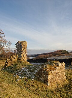
149:
143:
141:
135:
134:
132:
131:
125:
123:
117:
116:
114:
113:
107:
105:
99:
98:
96:
95:
91:
89:
83:
82:
79:
75:
74:
65:
59:
58:
51:
50:
44:
43:
42:
41:
38:
37:
34:
26:
25:
17:
13:
10:
9:
6:
4:
3:
2:
562:
551:
548:
547:
545:
538:
536:
531:
523:
516:
511:
508:
505:
500:
497:
485:
484:
479:
475:
469:
466:
461:
457:
451:
448:
432:
425:
419:
416:
409:
407:
405:
401:
396:
394:
390:
386:
381:
379:
374:
372:
371:Ripley Castle
368:
364:
360:
351:
347:
345:
342:
338:
335:
327:
325:
323:
319:
314:
312:
308:
304:
299:
297:
293:
289:
285:
275:
244:
241:
239:
236:
234:
231:
226:
225:
222:
218:
215:
212:
210:
203:
200:
198:
191:
188:
186:
174:
172:
164:
160:
158:
148:
145:
144:
142:
140:
130:
127:
126:
124:
122:
112:
109:
108:
106:
104:
93:
92:
90:
88:
84:
80:
76:
69:
48:
39:
32:
22:
16:
535:Haverah Park
527:
510:
499:
487:. Retrieved
481:
468:
459:
450:
438:. Retrieved
431:the original
418:
397:
382:
375:
356:
343:
336:
331:
315:
311:Beckwithshaw
300:
288:civil parish
284:Haverah Park
283:
282:
271:53.99; -1.63
94:Haverah Park
87:Civil parish
60:Haverah Park
24:Haverah Park
15:
440:12 November
387:operated a
361:within the
334:Old English
269: /
410:References
406:district.
389:cosmic ray
78:Population
404:Harrogate
359:deer park
341:Old Norse
296:Harrogate
243:Yorkshire
214:Yorkshire
209:Ambulance
544:Category
476:(2003).
458:(1961).
81:30
337:(ge)hæg
328:History
254:53°59′N
238:England
163:England
157:Country
489:6 June
257:1°38′W
185:Police
139:Region
434:(PDF)
427:(PDF)
309:with
286:is a
491:2014
442:2017
197:Fire
369:of
344:vrá
290:in
546::
480:.
395:.
373:.
313:.
298:.
233:UK
493:.
444:.
Text is available under the Creative Commons Attribution-ShareAlike License. Additional terms may apply.