95:, which was covered with straw and branches. In the centre, an oblong space was created, which was laid out with walkways and grass banks and was described as clean. In addition, a large earth pyramid was built, but there is no trace of it today. The purpose of the pyramid is unclear. It may have served as a signal station or lookout. According to local oral tradition, the discipline of these troops was much better than that of English,
17:
190:
80:
The tented camp on the shores of the Baltic Sea was erected by two companies of Hesse-Darmstadt troops in a wood. The troops belonged to those states in the
141:
91:. Strategically, the camp had the aim of preventing the landing of British troops on Rügen. There was an encampment laid out for 100 men and a
64:
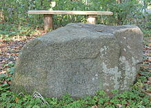
and run parallel to the road. The former encampment is commemorated at the highest point of the earthworks by a rock with the inscription
132:
60:. The camp was constructed in 1812. Today only remnants of the earthworks have survived; they have been designated as a
180:
68:("Hessian Camp in 1812"). In addition, an information board has been set up. Diagonally opposite is the museum ship,
52:
The camp was located south of Göhren in the vicinity of the south beach immediately west of the road from Göhren to
81:
185:
200:
37:
33:
100:
195:
128:
92:
107:
region. Behind the camp, tradesmen supplied provisions to the soldiers from their stalls.
16:
174:
96:
61:
104:
57:
156:
143:
103:
and French troops who, at that time, were also periodically stationed in the
85:
41:
88:
125:
Hünengrab und
Opferstein : Bodendenkmale auf der Insel Rügen.
53:
15:
110:
The area where the camp was erected had previously been known as
191:Heritage sites in Mecklenburg-Western Pomerania
32:is a former military encampment established by
8:
36:troops during the French occupation near
20:Monument to the Hessian Camp in Göhren
7:
14:
56:. Somewhat further east is the
66:Hessisches Lager im Jahre 1812
1:
217:
127:Hinstorff, Rostock, 2001,
82:Confederation of the Rhine
40:on the German island of
157:54.334931°N 13.737094°E
21:
19:
162:54.334931; 13.737094
84:that were allied to
153: /
22:
34:Hessian-Darmstadt
208:
168:
167:
165:
164:
163:
158:
154:
151:
150:
149:
146:
123:Ingrid Schmidt:
216:
215:
211:
210:
209:
207:
206:
205:
186:Napoleonic Wars
171:
170:
161:
159:
155:
152:
147:
144:
142:
140:
139:
120:
78:
50:
12:
11:
5:
214:
212:
204:
203:
198:
193:
188:
183:
173:
172:
137:
136:
119:
116:
77:
74:
49:
46:
13:
10:
9:
6:
4:
3:
2:
213:
202:
199:
197:
194:
192:
189:
187:
184:
182:
181:Göhren, Rügen
179:
178:
176:
169:
166:
135:, page 95 ff.
134:
133:3-356-00917-6
130:
126:
122:
121:
117:
115:
113:
108:
106:
102:
98:
94:
90:
87:
83:
75:
73:
71:
67:
63:
62:heritage site
59:
55:
47:
45:
43:
39:
35:
31:
27:
18:
138:
124:
111:
109:
79:
69:
65:
51:
30:Hessian Camp
29:
25:
23:
160: /
26:Hessenlager
175:Categories
148:13°44′14″E
145:54°20′06″N
118:Literature
114:(="key").
86:Napoleonic
58:Baltic Sea
201:Mönchgut
105:Mönchgut
97:Bavarian
48:Location
76:History
131:
112:Slötel
93:dugout
89:France
38:Göhren
196:Rügen
70:Luise
54:Lobbe
42:Rügen
129:ISBN
101:Berg
24:The
28:or
177::
99:,
72:.
44:.
Text is available under the Creative Commons Attribution-ShareAlike License. Additional terms may apply.