55:
370:
39:
943:
62:
327:
In 2018, it was announced that
Hermidale is the site of a new multi-user rail siding that will accommodate trains up to 1,200 metres long. It will enable trains to be loaded more efficiently, while other trains pass on the rail line. The new siding will result in 33,000 tonnes of freight each year
305:
but the opening of the
Budgery Copper Mine brought some prosperity to the village from around 1906. In 1923, mining became uneconomic due to low copper prices and the Budgery Mining Co. went into liquidation. By 1924, all levels of the mine were flooded; the mine water contained dissolved copper
300:
There were many mines near
Hermidale, the most important of which was the Budgery Copper Mine (north-west of the village). There were also some small gold mines in the far west of the modern-day locality, around Muriel Tank. Hermidale was initially the rail connection location for the mines at
324:, Hermidale has considerable passing traffic, bringing potential customers to the village, due to its location on the Barrier Highway. The village retains a sports ground, tennis courts, post office, public school and one hotel, and it has a small cemetery.
809:"Map of the village of Budgery and suburban lands [cartographic material] : parish of Hermitage, county of Canbelego, land district of Nyngan, Bogan Shire N.S.W. 1908 / compiled, drawn and printed at the Department of Lands"
306:
salts and copper was extracted from it. There was also a village of
Budgery—planned in 1908—but its design was cancelled in 1927, leaving Hermidale as the established community in the area.
235:
223:
289:
The area was originally known to settlers as
Hermitage Plains but postal authorities substituted the name Hermidale, in 1892, initially leading to some confusion with distant
297:
and a station was opened there in 1892. The village of
Hermidale was proclaimed on 18 July 1896. Sales of land took place in mid-1897. The public school opened in 1901.
54:
201:
1031:
864:
177:
1055:
96:
975:
1050:
213:
348:
988:
1009:
382:
228:
189:
89:
912:
1004:
968:
290:
252:
194:
953:
585:
352:
140:
132:
430:"Village of Hermidale and suburban lands [cartographic material] : Land District of Nyngan"
947:
1060:
961:
294:
240:
506:
255:
of New South Wales, Australia. It is 600km north-west of Sydney and the two closest towns are
279:
206:
369:
283:
264:
29:
860:"CIRCUIT COURT. A CHARGE OF MURDER. SOME STARTLING EVIDENCE. DEATH SENTENCE PRONOUNCED"
1044:
838:
Government
Gazette of the State of New South Wales (Sydney, NSW : 1901 - 2001)
271:
38:
404:
985:
278:
people. After settler colonisation, the site of
Hermidale lay partly within the
182:
887:
859:
833:
782:
730:
712:
660:
531:
480:
454:
316:
Unlike other former mining villages in the region, such as the ghost towns of
756:
686:
111:
98:
321:
310:
275:
636:"Budgery Copper Mine, Hermidale, Canbelego Co., New South Wales, Australia"
942:
808:
560:
635:
610:
999:
429:
317:
302:
1019:
256:
162:
156:
691:
Australian Town and
Country Journal (Sydney, NSW : 1870 - 1907)
270:
The area now known as
Hermidale is part of the traditional lands of
459:
New South Wales Government Gazette (Sydney, NSW : 1832 - 1900)
787:
Dubbo Dispatch and Wellington Independent (NSW : 1887 - 1932)
293:. What would become the village site lay astride the route of the
260:
168:
957:
267:. At the 2021 Census, the population of Hermidale was 127.
834:"PROPOSED CANCELLATION OF DESIGN OF THE VILLAGE OF BUDGERY"
888:"Australian Cemeteries Index - Cemetery 47 - Hermidale"
611:"Hermidale, Canbelego Co., New South Wales, Australia"
913:"Major road, rail initiatives delivered at Hermidale"
234:
222:
212:
200:
188:
176:
149:
139:
127:
88:
23:
665:Australian Star (Sydney, NSW : 1887 - 1909)
536:Daily Telegraph (Sydney, NSW : 1883 - 1930)
485:Australian Star (Sydney, NSW : 1887 - 1909)
761:Sydney Morning Herald (NSW : 1842 - 1954)
328:being switched from road transport to rail.
274:dialect speakers (also known as Wangaibon) of
969:
8:
282:(Parish of Hermitage) and partly within the
309:In 1913, Hermidale was the location of the
976:
962:
954:
368:
37:
20:
1032:Local government areas of New South Wales
865:Dubbo Dispatch and Wellington Independent
343:
341:
337:
735:Cobar Herald (NSW : 1899 - 1914)
18:Village in New South Wales, Australia
7:
555:
553:
424:
422:
263:(51 km to the west). It lies on the
917:Roads & Infrastructure Magazine
590:nswgovschoolhistory.cese.nsw.gov.au
14:
61:
941:
561:"Home - Hermidale Public School"
60:
53:
1056:Mining towns in New South Wales
840:. 21 October 1927. p. 5015
713:"Muriel, Bogan, NSW, Australia"
349:Australian Bureau of Statistics
161:600 km (373 mi) W of
868:. 12 September 1913. p. 1
737:. 22 September 1906. p. 4
565:hermidale-p.schools.nsw.gov.au
461:. 30 April 1892. pp. xiii
1:
667:. 28 November 1894. p. 3
311:murder of Mary Jane Greentree
167:51 km (32 mi) E of
155:46 km (29 mi) W of
693:. 3 October 1906. p. 38
487:. 30 August 1892. p. 6
75:Location in New South Wales
1077:
789:. 8 August 1924. p. 4
385:. Geographical Names Board
1028:
995:
763:. 12 May 1923. p. 22
84:
48:
36:
1051:Towns in New South Wales
538:. 9 June 1897. p. 6
259:(46 km to the east) and
112:31.531222°S 146.665361°E
984:Towns and Villages in
357:2021 Census QuickStats
117:-31.531222; 146.665361
989:local government area
783:"MINING AT HERMIDALE"
661:"MINING INTELLIGENCE"
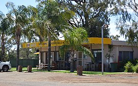
43:Hermidale Hotel, 2017
950:at Wikimedia Commons
731:"HERMIDALE TOWNSHIP"
251:is a village in the
507:"Hermidale Station"
286:(Parish of Boree).
280:County of Canbelego
236:Federal division(s)
224:State electorate(s)
108: /
295:Cobar railway line
284:County of Flinders
1038:
1037:
946:Media related to
532:"LAND SETTLEMENT"
332:Reference section
246:
245:
1068:
978:
971:
964:
955:
945:
929:
928:
926:
924:
909:
903:
902:
900:
898:
892:austcemindex.com
884:
878:
877:
875:
873:
856:
850:
849:
847:
845:
830:
824:
823:
821:
819:
813:trove.nla.gov.au
805:
799:
798:
796:
794:
779:
773:
772:
770:
768:
753:
747:
746:
744:
742:
727:
721:
720:
709:
703:
702:
700:
698:
683:
677:
676:
674:
672:
657:
651:
650:
648:
646:
632:
626:
625:
623:
621:
607:
601:
600:
598:
596:
582:
576:
575:
573:
571:
557:
548:
547:
545:
543:
528:
522:
521:
519:
517:
503:
497:
496:
494:
492:
477:
471:
470:
468:
466:
451:
445:
444:
442:
440:
426:
417:
416:
414:
412:
401:
395:
394:
392:
390:
379:
373:
372:
367:
365:
363:
351:(28 June 2022).
345:
123:
122:
120:
119:
118:
113:
109:
106:
105:
104:
101:
64:
63:
57:
41:
32:
26:
21:
1076:
1075:
1071:
1070:
1069:
1067:
1066:
1065:
1041:
1040:
1039:
1034:
1024:
991:
982:
938:
933:
932:
922:
920:
911:
910:
906:
896:
894:
886:
885:
881:
871:
869:
858:
857:
853:
843:
841:
832:
831:
827:
817:
815:
807:
806:
802:
792:
790:
781:
780:
776:
766:
764:
755:
754:
750:
740:
738:
729:
728:
724:
711:
710:
706:
696:
694:
685:
684:
680:
670:
668:
659:
658:
654:
644:
642:
634:
633:
629:
619:
617:
609:
608:
604:
594:
592:
584:
583:
579:
569:
567:
559:
558:
551:
541:
539:
530:
529:
525:
515:
513:
511:www.nswrail.net
505:
504:
500:
490:
488:
479:
478:
474:
464:
462:
453:
452:
448:
438:
436:
428:
427:
420:
410:
408:
407:. OpenStreetMap
403:
402:
398:
388:
386:
381:
380:
376:
361:
359:
347:
346:
339:
334:
265:Barrier Highway
116:
114:
110:
107:
102:
99:
97:
95:
94:
80:
79:
78:
77:
76:
72:
71:
70:
69:
65:
44:
30:New South Wales
28:
27:
24:
19:
12:
11:
5:
1074:
1072:
1064:
1063:
1058:
1053:
1043:
1042:
1036:
1035:
1030:Main Article:
1029:
1026:
1025:
1023:
1022:
1017:
1012:
1007:
1002:
996:
993:
992:
983:
981:
980:
973:
966:
958:
952:
951:
937:
936:External links
934:
931:
930:
919:. 29 July 2018
904:
879:
851:
825:
800:
774:
748:
722:
704:
678:
652:
640:www.mindat.org
627:
615:www.mindat.org
602:
577:
549:
523:
498:
472:
446:
418:
396:
374:
336:
335:
333:
330:
244:
243:
238:
232:
231:
226:
220:
219:
216:
210:
209:
204:
198:
197:
192:
186:
185:
180:
174:
173:
172:
171:
165:
159:
151:
147:
146:
143:
137:
136:
129:
125:
124:
92:
86:
85:
82:
81:
74:
73:
67:
66:
59:
58:
52:
51:
50:
49:
46:
45:
42:
34:
33:
17:
13:
10:
9:
6:
4:
3:
2:
1073:
1062:
1059:
1057:
1054:
1052:
1049:
1048:
1046:
1033:
1027:
1021:
1018:
1016:
1013:
1011:
1008:
1006:
1003:
1001:
998:
997:
994:
990:
987:
979:
974:
972:
967:
965:
960:
959:
956:
949:
944:
940:
939:
935:
918:
914:
908:
905:
893:
889:
883:
880:
867:
866:
861:
855:
852:
839:
835:
829:
826:
814:
810:
804:
801:
788:
784:
778:
775:
762:
758:
757:"Advertising"
752:
749:
736:
732:
726:
723:
718:
714:
708:
705:
692:
688:
682:
679:
666:
662:
656:
653:
641:
637:
631:
628:
616:
612:
606:
603:
591:
587:
581:
578:
566:
562:
556:
554:
550:
537:
533:
527:
524:
512:
508:
502:
499:
486:
482:
481:"Advertising"
476:
473:
460:
456:
450:
447:
435:
431:
425:
423:
419:
406:
400:
397:
384:
378:
375:
371:
358:
354:
350:
344:
342:
338:
331:
329:
325:
323:
319:
314:
312:
307:
304:
298:
296:
292:
287:
285:
281:
277:
273:
268:
266:
262:
258:
254:
250:
242:
239:
237:
233:
230:
227:
225:
221:
217:
215:
211:
208:
205:
203:
199:
196:
193:
191:
187:
184:
181:
179:
175:
170:
166:
164:
160:
158:
154:
153:
152:
148:
144:
142:
138:
134:
130:
126:
121:
103:146°39′55.3″E
93:
91:
87:
83:
56:
47:
40:
35:
31:
22:
16:
1014:
921:. Retrieved
916:
907:
895:. Retrieved
891:
882:
870:. Retrieved
863:
854:
842:. Retrieved
837:
828:
816:. Retrieved
812:
803:
791:. Retrieved
786:
777:
765:. Retrieved
760:
751:
739:. Retrieved
734:
725:
716:
707:
695:. Retrieved
690:
681:
669:. Retrieved
664:
655:
643:. Retrieved
639:
630:
618:. Retrieved
614:
605:
593:. Retrieved
589:
580:
568:. Retrieved
564:
540:. Retrieved
535:
526:
514:. Retrieved
510:
501:
489:. Retrieved
484:
475:
463:. Retrieved
458:
455:"Index page"
449:
437:. Retrieved
433:
409:. Retrieved
399:
387:. Retrieved
377:
360:. Retrieved
356:
326:
315:
308:
299:
288:
272:Wangaaypuwan
269:
253:Orana region
248:
247:
100:31°31′52.4″S
15:
1061:Bogan Shire
1010:Girilambone
986:Bogan Shire
687:"THE MINER"
595:19 December
586:"Hermidale"
405:"Hermidale"
383:"Hermidale"
353:"Hermidale"
183:Bogan Shire
141:Postcode(s)
133:2021 census
115: /
90:Coordinates
1045:Categories
872:26 January
697:19 October
411:10 October
389:10 October
362:4 November
131:127 (
128:Population
1015:Hermidale
948:Hermidale
897:9 October
844:8 October
818:8 October
793:8 October
767:8 October
741:8 October
671:8 October
645:8 October
620:8 October
570:8 October
542:8 October
516:8 October
491:8 October
465:8 October
439:8 October
322:Canbelego
276:Ngiyampaa
249:Hermidale
218:Hermitage
207:Canbelego
68:Hermidale
25:Hermidale
1005:Coolabah
291:Armidale
150:Location
1000:Bobadah
923:5 March
318:Bobadah
303:Nymagee
1020:Nyngan
717:Mindat
257:Nyngan
241:Parkes
229:Barwon
214:Parish
202:County
190:Region
178:LGA(s)
163:Sydney
157:Nyngan
434:Trove
261:Cobar
195:Orana
169:Cobar
925:2021
899:2020
874:2024
846:2020
820:2020
795:2020
769:2020
743:2020
699:2020
673:2020
647:2020
622:2020
597:2020
572:2020
544:2020
518:2020
493:2020
467:2020
441:2020
413:2020
391:2020
364:2022
320:and
145:2831
313:.
1047::
915:.
890:.
862:.
836:.
811:.
785:.
759:.
733:.
715:.
689:.
663:.
638:.
613:.
588:.
563:.
552:^
534:.
509:.
483:.
457:.
432:.
421:^
355:.
340:^
977:e
970:t
963:v
927:.
901:.
876:.
848:.
822:.
797:.
771:.
745:.
719:.
701:.
675:.
649:.
624:.
599:.
574:.
546:.
520:.
495:.
469:.
443:.
415:.
393:.
366:.
135:)
Text is available under the Creative Commons Attribution-ShareAlike License. Additional terms may apply.