20:
40:
295:
28:
260:
336:
136:, was erroneously transferred to this bay in the 1930s. This error has now been rectified and a new name approved for the feature here described. Hero Bay is named for the
360:
125:
238:
164:
from the exploration of the sloop Dove in the years 1821 and 1822 by George Powell
Commander of the same. Scale ca. 1:200000. London: Laurie, 1822.
329:
204:
196:
188:
274:
229:
355:
322:
269:
224:
177:
181:
279:
234:
180:(from English Strait to Morton Strait, with illustrations and ice-cover distribution), 1:100000 scale topographic map,
81:) is a bay, 17 nautical miles (31 km) wide, which indents for 6 nautical miles (11 km) the northern side of
53:
264:
173:
Islas
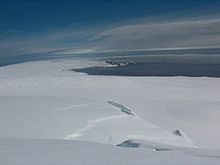
Livingston y Decepción. Mapa topográfico a escala 1:100000. Madrid: Servicio Geográfico del Ejército, 1991.
149:
129:
213:
Scale 1:250000 topographic map of
Antarctica. Scientific Committee on Antarctic Research (SCAR), 1993–2016.
94:
133:
98:
145:
19:
167:
106:
39:
161:
302:
200:
192:
82:
114:
102:
294:
306:
110:
90:
349:
137:
86:
32:
170:
Scale 1:200000 topographic map No. 5657. DOS 610 – W 62 60. Tolworth, UK, 1968.
121:
68:
55:
189:
Antarctica: Livingston Island and
Greenwich, Robert, Snow and Smith Islands.
178:
Antarctica: Livingston Island and
Greenwich Island, South Shetland Islands
191:
Scale 1:120000 topographic map. Troyan: Manfred Wörner
Foundation, 2010.
251:
27:
148:, which was one of the vessels of the Pendleton sealing fleet from
38:
26:
18:
124:", originally applied to a small bay on the southeast side of
162:
Chart of South
Shetland including Coronation Island, &c.
23:
Location of
Livingston Island in the South Shetland Islands.
210:
310:
152:, which visited the South Shetland Islands in 1820–21.
330:
8:
337:
323:
239:United States Department of the Interior
43:Topographic map of Livingston Island.
7:
291:
289:
275:Geographic Names Information System
230:Geographic Names Information System
252:SCAR Composite Antarctic Gazetteer
14:
361:Livingston Island geography stubs
211:Antarctic Digital Database (ADD).
16:Bay of the South Shetland Islands
293:
263: This article incorporates
258:
182:Antarctic Place-names Commission
280:United States Geological Survey
235:United States Geological Survey
1:
309:. You can help Knowledge by
132:chart of 1822 published by
377:
288:
356:Bays of Livingston Island
184:of Bulgaria, Sofia, 2005
168:South Shetland Islands.
150:Stonington, Connecticut
305:location article is a
265:public domain material
95:South Shetland Islands
44:
36:
24:
199:(First edition 2009.
134:Richard Holmes Laurie
42:
30:
22:
176:L.L. Ivanov et al.,
99:Saedinenie Snowfield
146:Nathaniel B. Palmer
65: /
45:
37:
25:
318:
317:
303:Livingston Island
205:978-954-92032-6-4
197:978-954-92032-9-5
126:Desolation Island
83:Livingston Island
69:62.517°S 60.450°W
368:
339:
332:
325:
297:
290:
283:
262:
261:
248:
246:
245:
144:, under Captain
80:
79:
77:
76:
75:
74:-62.517; -60.450
70:
66:
63:
62:
61:
58:
376:
375:
371:
370:
369:
367:
366:
365:
346:
345:
344:
343:
286:
268:
259:
243:
241:
223:
220:
158:
130:George Powell's
97:. The glaciers
73:
71:
67:
64:
59:
56:
54:
52:
51:
17:
12:
11:
5:
374:
372:
364:
363:
358:
348:
347:
342:
341:
334:
327:
319:
316:
315:
298:
256:
255:
249:
219:
216:
215:
214:
208:
185:
174:
171:
165:
157:
154:
117:feed the bay.
91:Williams Point
31:Hero Bay from
15:
13:
10:
9:
6:
4:
3:
2:
373:
362:
359:
357:
354:
353:
351:
340:
335:
333:
328:
326:
321:
320:
314:
312:
308:
304:
299:
296:
292:
287:
284:
281:
277:
276:
271:
266:
253:
250:
240:
236:
232:
231:
226:
222:
221:
217:
212:
209:
206:
202:
198:
194:
190:
187:L.L. Ivanov.
186:
183:
179:
175:
172:
169:
166:
163:
160:
159:
155:
153:
151:
147:
143:
139:
135:
131:
127:
123:
118:
116:
112:
108:
104:
100:
96:
92:
88:
87:Cape Shirreff
84:
78:
49:
41:
34:
29:
21:
311:expanding it
300:
285:
273:
257:
242:. Retrieved
228:
141:
119:
47:
46:
72: /
33:Miziya Peak
350:Categories
270:"Hero Bay"
244:2012-06-14
225:"Hero Bay"
218:References
122:Blythe Bay
120:The name "
107:Berkovitsa
93:, in the
138:American
115:Urdoviza
85:between
48:Hero Bay
103:Tundzha
60:60°27′W
57:62°31′S
203:
195:
140:sloop
111:Medven
301:This
267:from
307:stub
201:ISBN
193:ISBN
156:Maps
142:Hero
113:and
89:and
128:on
352::
278:.
272:.
237:,
233:.
227:.
109:,
105:,
101:,
338:e
331:t
324:v
313:.
282:.
254:.
247:.
207:)
50:(
35:.
Text is available under the Creative Commons Attribution-ShareAlike License. Additional terms may apply.

