302:
31:
345:
Work on the bridge began in
November 1902, locating it slightly to the south of the double-track bridge. The bridge was completed on 1 September 1904 and the main line was realigned to cross it, abandoning the old bridge. The realignment reduced the curvature in the area and completed the PRR's
341:
decided in favor of a stone bridge at this location and elsewhere. This reflected the influence of PRR Chief
Engineer William H. Brown, who rebuilt many of the railroad's bridges in masonry during his tenure. While more expensive than steel, Brown felt that stone bridges were stronger and more
261:
between 1902 and 1904, it has ten arches (eight of 78 feet (24 m) and two of 88 feet (27 m)) and spans a total length of 934 feet (285 m), with wing walls extending it to 1,287 feet (392 m). 78 feet (24 m) high, the bridge was built to accommodate four
324:
in 1890. By around the start of the 20th century, however, the double-track bridge was proving to be a bottleneck in the quadruple-track main line on both sides, and plans were made for a bridge that would carry four tracks across the
Brandywine Valley.
617:
642:
627:
597:
637:
647:
274:
544:
622:
602:
48:
185:
313:
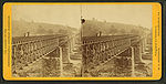
in 1832. It was a single-track wood span on stone piers. The bridge was widened to double-track in 1854. This bridge was replaced by a
632:
612:
310:
578:
534:
270:
368:
was added to the bridge and the tops of some arches were reinforced with concrete. Catenary poles were added to the bridge with
301:
369:
337:
bridges since the 1880s, and was constructing others nearby at the time, such as the High Bridge at
Downingtown, President
250:
97:
83:
41:
254:
282:
607:
355:
420:
290:
258:
87:
551:
574:
530:
338:
286:
351:
30:
263:
203:
591:
237:
373:
347:
318:
372:
in the 1930s. Ownership of the bridge passed, with the rest of the Main Line, to
321:
63:
50:
618:
Railroad bridges on the
National Register of Historic Places in Pennsylvania
314:
278:
362:
243:
273:
passes along the north side of
Coatesville on the southern slope of the
365:
246:
377:
643:
National
Register of Historic Places in Chester County, Pennsylvania
334:
300:
240:
266:
railroad tracks, with a total length of 52 feet (16 m).
412:
342:
durable, and less expensive to maintain in the long term.
545:"Pennsylvania Railroad: Brick Viaduct (HAER PA-38)"
221:
209:
196:
156:
146:
141:
133:
125:
117:
112:
104:
93:
79:
40:
21:
305:Stereoscopic view of earlier Coatesville Bridge
309:The first bridge at the site was built by the
277:. The bridge carries the Main Line across the
281:cut by the Brandywine, as well as the former
8:
571:The Pennsylvania Railroad 1940s–1950s
35:View of the bridge from the southeast side.
18:
186:U.S. National Register of Historic Places
628:Bridges in Chester County, Pennsylvania
463:
461:
459:
457:
455:
398:
396:
394:
392:
388:
598:Deck arch bridges in the United States
317:bridge in 1867, and that in turn by a
16:Bridge in Pennsylvania, United States
7:
417:National Register of Historic Places
638:1904 establishments in Pennsylvania
648:Brick bridges in the United States
311:Philadelphia and Columbia Railroad
14:
29:
249:that crosses the valley of the
198:
1:
623:Viaducts in the United States
603:Pennsylvania Railroad bridges
333:While the PRR had been using
100:, Pennsylvania, United States
269:The Pennsylvania Railroad's
251:West Branch Brandywine Creek
84:West Branch Brandywine Creek
529:. Barnard, Roberts and Co.
160:September 1, 1904
664:
346:four-track main line from
633:Coatesville, Pennsylvania
613:Bridges completed in 1904
255:Coatesville, Pennsylvania
226:
217:
197:NRHP reference
192:
183:
179:
175:
171:
28:
525:Messer, David W (1999).
329:Construction and history
121:934 ft (285 m)
283:Wilmington and Northern
234:Coatesville High Bridge
569:Ball Jr., Don (1986).
306:
137:78 ft (24 m)
129:52 ft (16 m)
421:National Park Service
304:
291:Pennsylvania Route 82
259:Pennsylvania Railroad
152:Pennsylvania Railroad
88:Pennsylvania Route 82
64:39.98389°N 75.82750°W
69:39.98389; -75.82750
60: /
573:. Elm Tree Books.
361:In later years, a
307:
275:North Valley Hills
230:
229:
655:
584:
565:
563:
562:
556:
550:. Archived from
549:
540:
513:
510:
504:
501:
495:
492:
486:
485:HAER PA-38, p. 5
483:
477:
474:
468:
465:
450:
447:
441:
438:
432:
431:
429:
427:
409:
403:
400:
287:Reading Railroad
200:
167:
165:
149:
75:
74:
72:
71:
70:
65:
61:
58:
57:
56:
53:
33:
19:
663:
662:
658:
657:
656:
654:
653:
652:
588:
587:
581:
568:
560:
558:
554:
547:
543:
537:
524:
521:
516:
511:
507:
502:
498:
493:
489:
484:
480:
475:
471:
466:
453:
448:
444:
439:
435:
425:
423:
411:
410:
406:
401:
390:
386:
370:electrification
352:Conestoga River
331:
299:
257:. Built by the
188:
163:
161:
147:
113:Characteristics
68:
66:
62:
59:
54:
51:
49:
47:
46:
36:
24:
17:
12:
11:
5:
661:
659:
651:
650:
645:
640:
635:
630:
625:
620:
615:
610:
608:Amtrak bridges
605:
600:
590:
589:
586:
585:
579:
566:
541:
535:
520:
517:
515:
514:
512:Messer, p. 115
505:
503:Messer, p. 114
496:
487:
478:
469:
467:Messer, p. 112
451:
449:Messer, p. 111
442:
440:Messer, p. 109
433:
404:
402:Messer, p. 113
387:
385:
382:
330:
327:
298:
295:
285:Branch of the
264:standard gauge
228:
227:
224:
223:
219:
218:
215:
214:
213:March 26, 1976
211:
207:
206:
201:
194:
193:
190:
189:
184:
181:
180:
177:
176:
173:
172:
169:
168:
158:
154:
153:
150:
148:Constructed by
144:
143:
139:
138:
135:
131:
130:
127:
123:
122:
119:
115:
114:
110:
109:
106:
102:
101:
95:
91:
90:
81:
77:
76:
44:
38:
37:
34:
26:
25:
22:
15:
13:
10:
9:
6:
4:
3:
2:
660:
649:
646:
644:
641:
639:
636:
634:
631:
629:
626:
624:
621:
619:
616:
614:
611:
609:
606:
604:
601:
599:
596:
595:
593:
582:
580:0-393-02357-5
576:
572:
567:
557:on 2011-06-04
553:
546:
542:
538:
536:0-934118-24-8
532:
528:
523:
522:
518:
509:
506:
500:
497:
491:
488:
482:
479:
476:Messer, p. 89
473:
470:
464:
462:
460:
458:
456:
452:
446:
443:
437:
434:
426:September 17,
422:
418:
414:
408:
405:
399:
397:
395:
393:
389:
383:
381:
379:
375:
371:
367:
364:
359:
357:
353:
349:
343:
340:
339:A. J. Cassatt
336:
328:
326:
323:
320:
316:
312:
303:
296:
294:
292:
288:
284:
280:
276:
272:
267:
265:
260:
256:
252:
248:
245:
242:
239:
238:stone masonry
235:
225:
220:
216:
212:
210:Added to NRHP
208:
205:
202:
195:
191:
187:
182:
178:
174:
170:
159:
155:
151:
145:
140:
136:
132:
128:
124:
120:
116:
111:
107:
105:Maintained by
103:
99:
96:
92:
89:
85:
82:
78:
73:
45:
43:
39:
32:
27:
20:
570:
559:. Retrieved
552:the original
526:
508:
499:
490:
481:
472:
445:
436:
424:. Retrieved
416:
407:
376:in 1968 and
374:Penn Central
360:
354:bridge near
348:Philadelphia
344:
332:
319:wrought iron
308:
268:
233:
231:
118:Total length
413:"NPS Focus"
322:Pratt truss
67: /
42:Coordinates
23:High Bridge
592:Categories
561:2008-07-03
527:Triumph II
519:References
494:Ball p. 59
297:Precursors
164:1904-09-01
55:75°49′39″W
380:in 1976.
356:Lancaster
315:cast iron
279:water gap
271:Main Line
52:39°59′2″N
363:concrete
244:railroad
222:Location
204:76001623
366:parapet
350:to the
247:viaduct
162: (
142:History
98:Chester
80:Crosses
577:
533:
378:Amtrak
134:Height
108:Amtrak
94:Locale
555:(PDF)
548:(PDF)
384:Notes
335:steel
236:is a
157:Built
126:Width
575:ISBN
531:ISBN
428:2011
289:and
241:arch
232:The
86:and
253:at
199:No.
594::
454:^
419:.
415:.
391:^
358:.
293:.
583:.
564:.
539:.
430:.
166:)
Text is available under the Creative Commons Attribution-ShareAlike License. Additional terms may apply.