133:
140:
488:
22:
357:
During the 1904 survey of Lake
Temagami, it was determined that lots on High Rock Island (Island 312) were not to made available to cottagers until the timber on the island was harvested. The 1930s creation of the Skyline Reserve meant that trees within 90 meters of shore would not be cut, so
350:. The path and the top of High Rock have human-made depressions and rock piles that were used for defensive purposes. The lookout at the top was used as a watch tower by the ancestor of the
529:
456:
190:
563:
379:
568:
548:
375:
522:
132:
39:
515:
466:
105:
276:
86:
58:
553:
43:
558:
65:
183:
273:
72:
224:
343:
229:
54:
32:
358:
commercial logging never occurred on the island. At some point, a few cottages were built on the island.
351:
405:"A Lake through Time: Archaeological and Palaeo-Environmental Investigations at Lake Temagami, 1985–1994"
404:
347:
299:
219:
295:
79:
462:
329:
495:
318:
433:
268:
260:
487:
499:
339:
332:
253:
542:
322:
279:
246:
21:
205:
192:
310:
302:
152:
458:
Temagami Lakes
Association: The Life and Times of a Cottage Community
173:
156:
291:
354:
to detect if
Iroquois were coming from the north or the south.
15:
503:
328:
The lookout at the north end of High Rock Island is a
267:
252:
242:
237:
182:
172:
167:
120:
46:. Unsourced material may be challenged and removed.
380:Ontario Ministry of Northern Development and Mines
523:
8:
530:
516:
117:
106:Learn how and when to remove this message
398:
396:
367:
461:. Trafford Publishing. p. 14,81.
564:Mountains of Canada under 1000 metres
7:
484:
482:
44:adding citations to reliable sources
14:
139:
569:Northern Ontario geography stubs
549:Sacred mountains of the Americas
486:
138:
131:
20:
31:needs additional citations for
346:, is considered sacred to the
1:
502:. You can help Knowledge by
309:southwest of the village of
225:Geographical Names Data Base
585:
498:geographical article is a
481:
178:371 m (1,217 ft)
455:Sinclair, Pamela (2011).
403:Gordon, Diana L. (2013).
125:
230:Natural Resources Canada
55:"High Rock" Ontario
313:. The highest point on
307:24 km (15 mi)
352:Teme-Augama Anishnabai
338:High Rock, along with
554:Landforms of Temagami
348:Temagami First Nation
206:46.92000°N 80.04417°W
559:Mountains of Ontario
317:, it is one of many
40:improve this article
412:Ontario Archaeology
211:46.92000; -80.04417
202: /
305:, Canada, located
296:Nipissing District
220:"High Rock Island"
168:Highest point
511:
510:
436:. smoothwater.com
330:Nipissing diabase
319:scenic viewpoints
285:
284:
116:
115:
108:
90:
576:
532:
525:
518:
496:Northern Ontario
490:
483:
473:
472:
452:
446:
445:
443:
441:
430:
424:
423:
421:
419:
409:
400:
391:
390:
388:
387:
372:
315:High Rock Island
308:
256:
233:
217:
216:
214:
213:
212:
207:
203:
200:
199:
198:
195:
142:
141:
135:
118:
111:
104:
100:
97:
91:
89:
48:
24:
16:
584:
583:
579:
578:
577:
575:
574:
573:
539:
538:
537:
536:
479:
477:
476:
469:
454:
453:
449:
439:
437:
432:
431:
427:
417:
415:
407:
402:
401:
394:
385:
383:
374:
373:
369:
364:
306:
263:, unnamed range
261:Canadian Shield
254:
218:
210:
208:
204:
201:
196:
193:
191:
189:
188:
163:
162:
161:
160:
159:
150:
149:
148:
147:
143:
112:
101:
95:
92:
49:
47:
37:
25:
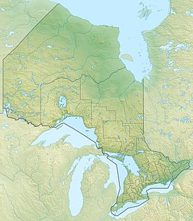
12:
11:
5:
582:
580:
572:
571:
566:
561:
556:
551:
541:
540:
535:
534:
527:
520:
512:
509:
508:
491:
475:
474:
467:
447:
425:
392:
366:
365:
363:
360:
344:Maple Mountain
340:Devil Mountain
283:
282:
271:
265:
264:
258:
250:
249:
244:
240:
239:
235:
234:
186:
180:
179:
176:
170:
169:
165:
164:
151:
145:
144:
137:
136:
130:
129:
128:
127:
126:
123:
122:
114:
113:
96:September 2024
28:
26:
19:
13:
10:
9:
6:
4:
3:
2:
581:
570:
567:
565:
562:
560:
557:
555:
552:
550:
547:
546:
544:
533:
528:
526:
521:
519:
514:
513:
507:
505:
501:
497:
492:
489:
485:
480:
470:
468:9781426967627
464:
460:
459:
451:
448:
435:
429:
426:
413:
406:
399:
397:
393:
381:
377:
376:"CLAIMaps IV"
371:
368:
361:
359:
355:
353:
349:
345:
341:
336:
334:
331:
326:
324:
323:Lake Temagami
320:
316:
312:
304:
301:
297:
293:
289:
281:
280:Lake Temagami
278:
275:
272:
270:
266:
262:
259:
257:
251:
248:
247:Lake Temagami
245:
241:
236:
231:
227:
226:
221:
215:
187:
185:
181:
177:
175:
171:
166:
158:
154:
134:
124:
119:
110:
107:
99:
88:
85:
81:
78:
74:
71:
67:
64:
60:
57: –
56:
52:
51:Find sources:
45:
41:
35:
34:
29:This article
27:
23:
18:
17:
504:expanding it
493:
478:
457:
450:
440:September 8,
438:. Retrieved
428:
418:September 8,
416:. Retrieved
411:
384:. Retrieved
370:
356:
337:
327:
314:
300:Northeastern
287:
286:
255:Parent range
223:
102:
93:
83:
76:
69:
62:
50:
38:Please help
33:verification
30:
434:"High Rock"
209: /
184:Coordinates
543:Categories
386:2018-01-14
362:References
197:80°02′39″W
194:46°55′12″N
66:newspapers
288:High Rock
238:Geography
174:Elevation
146:High Rock
121:High Rock
311:Temagami
269:Topo map
243:Location
303:Ontario
153:Ontario
80:scholar
465:
382:. 2016
157:Canada
82:
75:
68:
61:
53:
494:This
408:(PDF)
290:is a
277:41I16
87:JSTOR
73:books
500:stub
463:ISBN
442:2024
420:2024
414:(93)
342:and
333:dyke
292:hill
59:news
321:on
298:of
294:in
274:NTS
42:by
545::
410:.
395:^
378:.
335:.
325:.
228:.
222:.
155:,
531:e
524:t
517:v
506:.
471:.
444:.
422:.
389:.
232:.
109:)
103:(
98:)
94:(
84:·
77:·
70:·
63:·
36:.
Text is available under the Creative Commons Attribution-ShareAlike License. Additional terms may apply.