131:
148:
178:
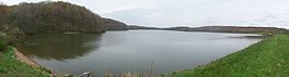
288:. It was created in 1966 when the State of Ohio built a dam impounding 170 acres (0.69 km) of water on the upper drainage of the Little Yellow Creek. A lot of habitat improvement was done on what would be the bottom of the lake prior to the impoundment. It has about 5 miles (8.0 km) of shoreline and a maximum depth of about 26 feet (7.9 m). The lake is about 1,100 feet (340 m) above sea level.
22:
185:
155:
291:
The dam is of earthen construction, rock fill. Its height is 44 feet (13 m) with a length of 1,476 feet (450 m). Maximum discharge is 4196 cubic feet per second. Its capacity is 5,710 acre-feet (0.00704 km). Normal storage is 2,700 acre-feet (0.0033 km). It drains an area of 5.8
324:
via State Route 39. A portion of the
Steubenville Pike Road (Township Road 776) was covered by the lake and it now dead ends at the lake. Osborne Road crosses the northwest arm of the lake. Charles Mill Road (County Highway 413) crosses the northern arm of the lake.
496:
304:. It is part of the 2,265 acres (9.17 km) Highlandtown Wildlife Area. It is within a mile of an area known as Highlandtown. It is four miles northeast of
285:
210:
224:
177:
147:
486:
334:
39:
105:
381:
appeared in the lake. Because of feeding patterns this resulted in bass getting bigger and bluegills getting smaller. White amurs (
86:
481:
58:
43:
441:
130:
65:
476:
72:
32:
301:
385:) have been introduced to control weeds and they have remove weed beds which were good places to fish for bass.
54:
459:
393:
There is parking, boat ramps, and a handicap dock for fishing. There is no camping in the wildlife area.
378:
317:
309:
79:
491:
321:
358:
350:
366:
470:
374:
362:
256:
313:
450:
370:
346:
305:
21:
423:
409:
404:
Fishing Ohio: An Angler's Guide to Over 200 Fishing Spots in the
Buckeye State.
382:
432:
239:
226:
261:
354:
15:
410:
Highlandtown Lake at Ohio
Department of Natural Resources
337:. The lake is at the headwaters of Little Yellow Creek.
424:
Highlandtown Lake at Ohio Dept. of
Natural Resources
271:
267:
255:
216:
206:
123:
46:. Unsourced material may be challenged and removed.
217:
8:
300:It is in the Wildlife District Three of the
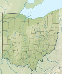
286:Washington Township, Columbiana County, Ohio
211:Washington Township, Columbiana County, Ohio
497:Bodies of water of Columbiana County, Ohio
120:
184:
154:
106:Learn how and when to remove this message
7:
451:Water Resources of Columbiana County
118:Reservoir in Columbiana County, Ohio
44:adding citations to reliable sources
406:Lyons Press, 2008, p. 147-149.
335:Appalachian mixed mesophytic forest
135:Panorama view from south end of dam
345:The lake was stocked in 1967 with
14:
183:
176:
153:
146:
129:
20:
270:
31:needs additional citations for
320:. It is 11 miles northwest of
284:is a man-made lake located in
1:
205:
197:Show map of the United States
487:Fishing in the United States
361:. At present there are also
292:square miles (15 km).
513:
433:Highlandtown Wildlife Area
302:Ohio Division of Wildlife
140:
128:
312:and nine miles south of
373:and other varieties of
275:1,073 feet (327 m)
482:Dams completed in 1966
442:Highlandtown Lake Map
379:American gizzard shad
240:40.64194°N 80.75889°W
460:EPA Watershed Report
40:improve this article
245:40.64194; -80.75889
236: /
55:"Highlandtown Lake"
477:Reservoirs in Ohio
282:Highlandtown Lake
279:
278:
272:Surface elevation
191:Highlandtown Lake
161:Highlandtown Lake
124:Highlandtown Lake
116:
115:
108:
90:
504:
463:
462:
454:
453:
445:
444:
436:
435:
427:
426:
377:. In about 2000
251:
250:
248:
247:
246:
241:
237:
234:
233:
232:
229:
219:
198:
187:
186:
180:
168:
167:Show map of Ohio
157:
156:
150:
133:
121:
111:
104:
100:
97:
91:
89:
48:
24:
16:
512:
511:
507:
506:
505:
503:
502:
501:
467:
466:
458:
457:
449:
448:
440:
439:
431:
430:
422:
421:
418:
399:
391:
367:brown bullheads
359:channel catfish
351:largemouth bass
343:
333:The area is an
331:
318:State Route 164
298:
244:
242:
238:
235:
230:
227:
225:
223:
222:
202:
201:
200:
199:
196:
195:
194:
193:
192:
188:
171:
170:
169:
166:
165:
164:
163:
162:
158:
136:
119:
112:
101:
95:
92:
49:
47:
37:
25:
12:
11:
5:
510:
508:
500:
499:
494:
489:
484:
479:
469:
468:
465:
464:
455:
446:
437:
428:
417:
416:External links
414:
413:
412:
407:
398:
395:
390:
387:
342:
339:
330:
327:
310:State Route 39
297:
294:
277:
276:
273:
269:
268:
265:
264:
259:
253:
252:
220:
214:
213:
208:
204:
203:
190:
189:
182:
181:
175:
174:
173:
172:
160:
159:
152:
151:
145:
144:
143:
142:
141:
138:
137:
134:
126:
125:
117:
114:
113:
28:
26:
19:
13:
10:
9:
6:
4:
3:
2:
509:
498:
495:
493:
490:
488:
485:
483:
480:
478:
475:
474:
472:
461:
456:
452:
447:
443:
438:
434:
429:
425:
420:
419:
415:
411:
408:
405:
401:
400:
396:
394:
388:
386:
384:
380:
376:
372:
368:
364:
363:black crappie
360:
356:
352:
348:
340:
338:
336:
328:
326:
323:
319:
315:
311:
307:
303:
295:
293:
289:
287:
283:
274:
266:
263:
260:
258:
254:
249:
221:
215:
212:
209:
179:
149:
139:
132:
127:
122:
110:
107:
99:
88:
85:
81:
78:
74:
71:
67:
64:
60:
57: –
56:
52:
51:Find sources:
45:
41:
35:
34:
29:This article
27:
23:
18:
17:
403:
402:Cross, Tom.
392:
371:pumpkinseeds
344:
332:
299:
290:
281:
280:
102:
93:
83:
76:
69:
62:
50:
38:Please help
33:verification
30:
347:muskellunge
306:Salineville
243: /
218:Coordinates
471:Categories
397:References
389:Facilities
383:grass carp
322:Wellsville
231:80°45′32″W
228:40°38′31″N
96:March 2018
66:newspapers
329:Geography
262:Reservoir
355:bluegill
296:Location
207:Location
492:Boating
375:sunfish
80:scholar
357:, and
314:Lisbon
82:
75:
68:
61:
53:
87:JSTOR
73:books
341:Fish
316:via
308:via
257:Type
59:news
42:by
473::
369:,
365:,
353:,
349:,
109:)
103:(
98:)
94:(
84:·
77:·
70:·
63:·
36:.
Text is available under the Creative Commons Attribution-ShareAlike License. Additional terms may apply.