37:
329:
305:
Like all the stations on the line the platforms and buildings were of timber construction. Regular passenger services on the line finished on
Saturday 30 October 1954. Occasional special passenger trains used the station until 7 October 1963 when the station was closed completely. The station was
309:
At
Hindlow was a sidings for Ryan, Somerville and Company, and another for W.Spencer and Company (later Buxton Lime Firms Ltd.) These were two of the many lime works served by this stretch of line, which covered everything with a patina of white powder which on many photographs from this era is
293:
At this time the C&HPR line to Whaley Bridge was closed. Just before the station there was a junction to a stub of the old line which continued to serve the
Hillhead branch. The junction was known as the Buxton and High Peak Junction, not to be confused with
1431:
1426:
1421:
621:
681:
492:
107:
313:
After a fairly easy stretch of 1 in 330 from
Beswick's Sidings, the line began to climb again at 1 in 60 through Hindlow Tunnel to the summit at Brigg's Sidings and
1411:
1149:
1091:
1010:
656:
1116:
1111:
69:
1330:
1222:
1184:
987:
982:
1159:
1139:
1076:
1106:
1066:
485:
1385:
1289:
853:
813:
1309:
1033:
954:
843:
1299:
1217:
1199:
944:
553:
156:
1375:
1360:
478:
1242:
548:
861:
790:
36:
1247:
1237:
1179:
1043:
631:
601:
528:
373:
280:
146:
1294:
1005:
876:
780:
1340:
1227:
1169:
1164:
977:
891:
563:
405:
378:
249:
136:
1350:
1284:
1272:
1262:
1086:
911:
795:
735:
611:
518:
361:
328:
276:
The
Cromford and High Peak Railway goods station opened in 1833. It was opened for passengers in 1856 but closed in 1877.
101:
1380:
1194:
1101:
1081:
972:
939:
896:
641:
538:
1370:
1365:
949:
886:
823:
818:
740:
646:
636:
596:
586:
387:
314:
288:
1174:
1071:
871:
828:
765:
689:
571:
533:
523:
606:
1355:
1232:
1189:
1028:
881:
838:
775:
755:
651:
576:
543:
437:
The
Ashbourne News and Dove Valley Record, 28 October and 4 November 1954. Available Derby Local Studies Library
1335:
1325:
1304:
1061:
1020:
934:
901:
833:
785:
770:
750:
745:
717:
694:
666:
1390:
1345:
1257:
1209:
1096:
929:
760:
712:
671:
591:
1416:
1038:
919:
866:
661:
1252:
1121:
997:
924:
805:
727:
265:
1276:
1131:
1053:
55:
295:
233:
470:
964:
510:
284:
237:
1405:
704:
253:
465:
Railways of the High Peak: Buxton to
Ashbourne (Scenes From The Past series 32),
310:
mistaken for snow. This section still exists, serving the lime works at Dowlow.
502:
245:
84:
71:
299:
257:
241:
261:
474:
448:
Railway Track
Diagrams Book 4: Midlands and North West,
1318:
1271:
1208:
1148:
1130:
1052:
1019:
996:
963:
910:
852:
804:
726:
703:
680:
620:
562:
509:
207:
199:
191:
183:
175:
167:
162:
152:
142:
132:
127:
119:
114:
100:
63:
51:
46:
23:
1432:Former London and North Western Railway stations
1427:Railway stations in Great Britain closed in 1954
1422:Railway stations in Great Britain opened in 1856
486:
16:Former railway station in Derbyshire, England
8:
493:
479:
471:
35:
20:
340:
279:A new station was opened in 1894 by the
417:
324:
298:at the other end of the C&HPR near
1412:Disused railway stations in Derbyshire
854:Derbyshire and Staffordshire extension
232:was opened for goods in 1833 near to
7:
157:London, Midland and Scottish Railway
1210:GCR Main Line and Chesterfield loop
426:The Directory of Railway Stations,
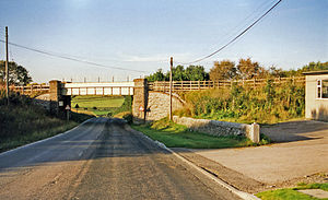
41:Location of Hindlow station (1999)
14:
463:Bentley, J.M., Fox, G.K., (1997)
374:London and North Western Railway
327:
147:London and North Western Railway
912:Ripley and Heanor branch lines
682:Sheffield & Midland C'ttee
564:Cromford and High Peak Railway
406:Cromford and High Peak Railway
379:Cromford and High Peak Railway
250:Cromford and High Peak Railway
137:Cromford and High Peak Railway
1:
1092:Ilkeston Junction and Cossall
1011:Castle Donington and Shardlow
203:closed to scheduled services
657:Great Longstone for Ashford
622:Manchester, Buxton, Matlock
501:Closed railway stations in
467:Romiley: Foxline Publishing
450:Bradford-on-Avon: Trackmaps
1448:
1331:Chapel-en-le-Frith Central
1223:Sheepbridge and Brimington
1185:Upperthorpe and Killamarsh
983:Chellaston and Swarkestone
1160:Chesterfield Market Place
1140:Eastwood and Langley Mill
1077:Codnor Park and Ironville
446:Jacobs, G., (Ed.) (2005)
386:
372:
360:
223:
219:
215:
34:
1107:Stapleford and Sandiacre
1067:Westhouses and Blackwell
1021:Midland Counties Railway
781:Springfield (Derbyshire)
428:Yeovil: Patrick Stephens
171:Station opened for goods
392:Line and station closed
366:Line and station closed
230:Hindlow railway station
1386:Woodville (Derbyshire)
1290:Clowne and Barlborough
1152:and East Coast Railway
1150:Lancashire, Derbyshire
1117:Long Eaton (1863–1967)
1112:Long Eaton (1847–1863)
814:Eckington and Renishaw
1376:Tibshelf & Newton
1310:Rowthorn and Hardwick
1034:Draycott and Breaston
998:Castle Donington line
955:Langley Mill (Branch)
844:Derby Nottingham Road
806:North Midland Railway
728:Ashover Light Railway
424:Butt, R.V.J., (1995)
240:to the south east of
179:Opened for passengers
1300:Palterton and Sutton
1218:Chesterfield Central
1200:Creswell and Welbeck
945:Crosshill and Codnor
796:Claycross and Egstow
612:Cromford (C&HPR)
554:Norbury and Ellaston
1361:Pinxton and Selston
1132:Pinxton branch line
1054:Erewash Valley line
624:and Midland Jcn Rly
287:from a junction at
285:branch to Ashbourne
81: /
47:General information
1243:Killamarsh Central
549:Clifton (Mayfield)
356:Following station
344:Preceding station
296:High Peak Junction
283:when it built its
85:53.2203°N 1.8729°W
1399:
1398:
862:Egginton Junction
791:Chesterfield Road
397:
396:
393:
381:
367:
350:Disused railways
306:removed in 1966.
227:
226:
115:Other information
1439:
1277:Doe Lea branches
1248:Renishaw Central
1238:Staveley Central
1180:Shirebrook North
1044:Long Eaton (MCR)
632:Buxton (Midland)
602:Hopton Top Wharf
529:Alsop en le Dale
495:
488:
481:
472:
451:
444:
438:
435:
429:
422:
391:
377:
365:
341:
331:
252:(which ran from
133:Original company
110:
96:
95:
93:
92:
91:
90:53.2203; -1.8729
86:
82:
79:
78:
77:
74:
39:
21:
1447:
1446:
1442:
1441:
1440:
1438:
1437:
1436:
1402:
1401:
1400:
1395:
1314:
1295:Bolsover Castle
1267:
1204:
1151:
1144:
1126:
1048:
1015:
1006:Weston on Trent
992:
959:
906:
877:Derby Friargate
848:
800:
722:
699:
676:
623:
616:
558:
505:
499:
460:
455:
454:
445:
441:
436:
432:
423:
419:
414:
402:
390:
376:
364:
339:
332:
323:
274:
268:and the south.
200:1 November 1954
106:
89:
87:
83:
80:
75:
72:
70:
68:
67:
58:
42:
30:
29:
28:
17:
12:
11:
5:
1445:
1443:
1435:
1434:
1429:
1424:
1419:
1414:
1404:
1403:
1397:
1396:
1394:
1393:
1388:
1383:
1378:
1373:
1368:
1363:
1358:
1353:
1348:
1343:
1341:Fairfield Halt
1338:
1333:
1328:
1322:
1320:
1316:
1315:
1313:
1312:
1307:
1302:
1297:
1292:
1287:
1281:
1279:
1269:
1268:
1266:
1265:
1260:
1255:
1250:
1245:
1240:
1235:
1230:
1228:Staveley Works
1225:
1220:
1214:
1212:
1206:
1205:
1203:
1202:
1197:
1192:
1187:
1182:
1177:
1172:
1170:Bolsover South
1167:
1165:Arkwright Town
1162:
1156:
1154:
1146:
1145:
1143:
1142:
1136:
1134:
1128:
1127:
1125:
1124:
1119:
1114:
1109:
1104:
1099:
1094:
1089:
1084:
1079:
1074:
1069:
1064:
1058:
1056:
1050:
1049:
1047:
1046:
1041:
1036:
1031:
1025:
1023:
1017:
1016:
1014:
1013:
1008:
1002:
1000:
994:
993:
991:
990:
985:
980:
978:Sinfin Central
975:
969:
967:
965:Melbourne line
961:
960:
958:
957:
952:
947:
942:
937:
932:
927:
922:
916:
914:
908:
907:
905:
904:
899:
894:
892:Ilkeston North
889:
884:
879:
874:
869:
864:
858:
856:
850:
849:
847:
846:
841:
836:
831:
826:
821:
816:
810:
808:
802:
801:
799:
798:
793:
788:
783:
778:
773:
768:
763:
758:
753:
748:
743:
738:
732:
730:
724:
723:
721:
720:
715:
709:
707:
701:
700:
698:
697:
692:
686:
684:
678:
677:
675:
674:
669:
664:
659:
654:
649:
644:
639:
634:
628:
626:
618:
617:
615:
614:
609:
604:
599:
594:
589:
584:
579:
574:
568:
566:
560:
559:
557:
556:
551:
546:
541:
536:
531:
526:
521:
515:
513:
511:Ashbourne line
507:
506:
500:
498:
497:
490:
483:
475:
469:
468:
459:
456:
453:
452:
439:
430:
416:
415:
413:
410:
409:
408:
401:
398:
395:
394:
385:
382:
371:
368:
358:
357:
354:
351:
348:
345:
338:
335:
334:
333:
326:
322:
319:
273:
270:
238:King Sterndale
225:
224:
221:
220:
217:
216:
213:
212:
209:
208:7 October 1963
205:
204:
201:
197:
196:
193:
189:
188:
185:
181:
180:
177:
173:
172:
169:
165:
164:
160:
159:
154:
150:
149:
144:
140:
139:
134:
130:
129:
125:
124:
121:
117:
116:
112:
111:
104:
102:Grid reference
98:
97:
65:
61:
60:
53:
49:
48:
44:
43:
40:
32:
31:
26:
25:
24:
15:
13:
10:
9:
6:
4:
3:
2:
1444:
1433:
1430:
1428:
1425:
1423:
1420:
1418:
1417:Peak District
1415:
1413:
1410:
1409:
1407:
1392:
1389:
1387:
1384:
1382:
1379:
1377:
1374:
1372:
1369:
1367:
1364:
1362:
1359:
1357:
1354:
1352:
1351:Ramsline Halt
1349:
1347:
1344:
1342:
1339:
1337:
1334:
1332:
1329:
1327:
1324:
1323:
1321:
1317:
1311:
1308:
1306:
1303:
1301:
1298:
1296:
1293:
1291:
1288:
1286:
1285:Staveley Town
1283:
1282:
1280:
1278:
1274:
1270:
1264:
1263:Tibshelf Town
1261:
1259:
1256:
1254:
1251:
1249:
1246:
1244:
1241:
1239:
1236:
1234:
1231:
1229:
1226:
1224:
1221:
1219:
1216:
1215:
1213:
1211:
1207:
1201:
1198:
1196:
1193:
1191:
1188:
1186:
1183:
1181:
1178:
1176:
1173:
1171:
1168:
1166:
1163:
1161:
1158:
1157:
1155:
1153:
1147:
1141:
1138:
1137:
1135:
1133:
1129:
1123:
1120:
1118:
1115:
1113:
1110:
1108:
1105:
1103:
1100:
1098:
1095:
1093:
1090:
1088:
1087:Ilkeston Town
1085:
1083:
1080:
1078:
1075:
1073:
1070:
1068:
1065:
1063:
1060:
1059:
1057:
1055:
1051:
1045:
1042:
1040:
1037:
1035:
1032:
1030:
1027:
1026:
1024:
1022:
1018:
1012:
1009:
1007:
1004:
1003:
1001:
999:
995:
989:
986:
984:
981:
979:
976:
974:
971:
970:
968:
966:
962:
956:
953:
951:
948:
946:
943:
941:
938:
936:
933:
931:
928:
926:
923:
921:
918:
917:
915:
913:
909:
903:
900:
898:
895:
893:
890:
888:
885:
883:
880:
878:
875:
873:
870:
868:
865:
863:
860:
859:
857:
855:
851:
845:
842:
840:
837:
835:
832:
830:
827:
825:
822:
820:
817:
815:
812:
811:
809:
807:
803:
797:
794:
792:
789:
787:
784:
782:
779:
777:
774:
772:
769:
767:
764:
762:
759:
757:
754:
752:
749:
747:
744:
742:
739:
737:
736:Ashover Butts
734:
733:
731:
729:
725:
719:
716:
714:
711:
710:
708:
706:
705:Woodhead line
702:
696:
693:
691:
688:
687:
685:
683:
679:
673:
670:
668:
665:
663:
660:
658:
655:
653:
650:
648:
645:
643:
640:
638:
635:
633:
630:
629:
627:
625:
619:
613:
610:
608:
605:
603:
600:
598:
595:
593:
590:
588:
585:
583:
580:
578:
575:
573:
570:
569:
567:
565:
561:
555:
552:
550:
547:
545:
542:
540:
537:
535:
532:
530:
527:
525:
522:
520:
519:Higher Buxton
517:
516:
514:
512:
508:
504:
496:
491:
489:
484:
482:
477:
476:
473:
466:
462:
461:
457:
449:
443:
440:
434:
431:
427:
421:
418:
411:
407:
404:
403:
399:
389:
383:
380:
375:
369:
363:
362:Higher Buxton
359:
355:
352:
349:
346:
343:
342:
336:
330:
325:
321:Image gallery
320:
318:
316:
311:
307:
303:
301:
297:
291:
290:
286:
282:
277:
271:
269:
267:
263:
259:
255:
254:Whaley Bridge
251:
247:
243:
239:
235:
231:
222:
218:
214:
211:Final closure
210:
206:
202:
198:
195:reopened LNWR
194:
190:
186:
184:December 1877
182:
178:
174:
170:
166:
161:
158:
155:
153:Post-grouping
151:
148:
145:
141:
138:
135:
131:
126:
122:
118:
113:
109:
105:
103:
99:
94:
66:
62:
57:
54:
50:
45:
38:
33:
22:
19:
1381:Whiteborough
1195:Clowne South
1102:Stanton Gate
1082:Shipley Gate
973:Sinfin North
940:Little Eaton
897:Heanor (GNR)
642:Millers Dale
607:Steeplehouse
581:
539:Thorpe Cloud
464:
458:Bibliography
447:
442:
433:
425:
420:
312:
308:
304:
292:
278:
275:
229:
228:
143:Pre-grouping
18:
1371:Swadlincote
1366:Sheepbridge
950:Heanor (MR)
887:West Hallam
824:Whittington
819:Barrow Hill
741:Salter Lane
647:Monsal Dale
637:Peak Forest
597:Parsley Hay
587:Dowlow Halt
388:Dowlow Halt
315:Dowlow Halt
289:Parsley Hay
192:1 June 1894
88: /
64:Coordinates
1406:Categories
1175:Scarcliffe
1072:Pye Bridge
872:Mickleover
829:Clay Cross
766:Hurst Lane
690:Birch Vale
572:Shallcross
534:Tissington
524:Hartington
503:Derbyshire
412:References
260:) and the
246:Derbyshire
73:53°13′13″N
1356:Hazelwood
1233:Grassmoor
1190:Spinkhill
1029:Borrowash
988:Melbourne
882:Breadsall
839:Wingfield
776:Clay Lane
756:Dale Bank
652:Longstone
577:Ladmanlow
544:Ashbourne
266:Ashbourne
176:July 1856
168:June 1833
163:Key dates
76:1°52′22″W
56:High Peak
1336:Egginton
1326:Buxworth
1305:Glapwell
1062:Doe Hill
935:Coxbench
902:Marlpool
834:Stretton
786:Holmgate
771:Stretton
751:Milltown
746:Fallgate
718:Woodhead
695:Hayfield
667:Bakewell
400:See also
300:Cromford
264:line to
258:Cromford
108:SK086692
52:Location
1391:Unstone
1346:Gresley
1258:Pilsley
1097:Trowell
930:Kilburn
761:Woolley
713:Crowden
672:Rowsley
592:Hurdlow
582:Hindlow
384:
370:
353:
347:
272:History
248:on the
234:Hindlow
128:History
123:Disused
59:England
27:Hindlow
1273:Clowne
1039:Sawley
920:Ripley
867:Etwall
662:Hassop
242:Buxton
187:closed
120:Status
1319:Other
1253:Heath
1122:Trent
925:Denby
337:Route
236:near
1275:and
281:LNWR
262:LNWR
256:to
1408::
317:.
302:.
244:,
494:e
487:t
480:v
Text is available under the Creative Commons Attribution-ShareAlike License. Additional terms may apply.